Stone Lines [Tunisia]
- Creation:
- Update:
- Compiler: Wafa Saidi
- Editors: Siagbé Golli, Faouzi Harrouchi, faouzi BATTI, Fatma Maaloul, Tabitha Nekesa, Ahmadou Gaye
- Reviewers: William Critchley, Rima Mekdaschi Studer
الاشرطة الحجرية
technologies_6610 - Tunisia
View sections
Expand all Collapse all1. General information
1.2 Contact details of resource persons and institutions involved in the assessment and documentation of the Technology
Key resource person(s)
SLM specialist:
Missaoui Farhat
Arrondissement Conservation des Eaux et des Sols, Commissariats Régionaux au Développement Agricole Kasserine
Tunisia
Name of project which facilitated the documentation/ evaluation of the Technology (if relevant)
Soil protection and rehabilitation for food security (ProSo(i)l)Name of the institution(s) which facilitated the documentation/ evaluation of the Technology (if relevant)
Direction Générale de l’Amenagement et de Conservation des Terres Agricoles (DG/ACTA) - TunisiaName of the institution(s) which facilitated the documentation/ evaluation of the Technology (if relevant)
GIZ Tunisia (GIZ Tunisia) - Tunisia1.3 Conditions regarding the use of data documented through WOCAT
The compiler and key resource person(s) accept the conditions regarding the use of data documented through WOCAT:
Yes
1.4 Declaration on sustainability of the described Technology
Is the Technology described here problematic with regard to land degradation, so that it cannot be declared a sustainable land management technology?
No
2. Description of the SLM Technology
2.1 Short description of the Technology
Definition of the Technology:
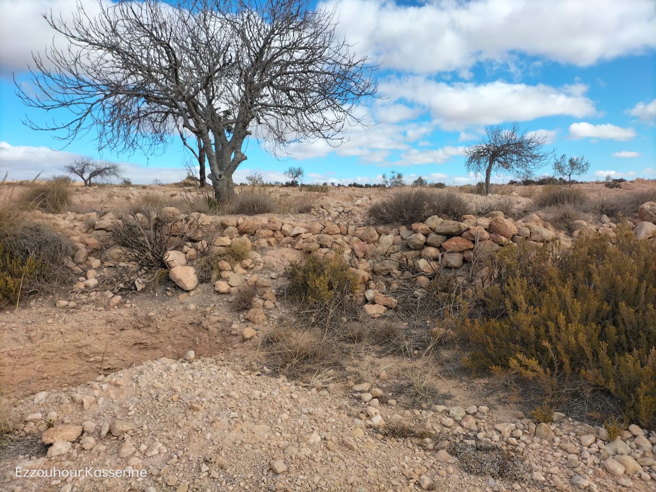
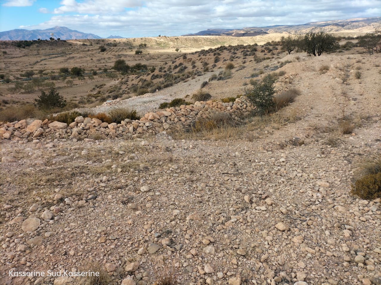
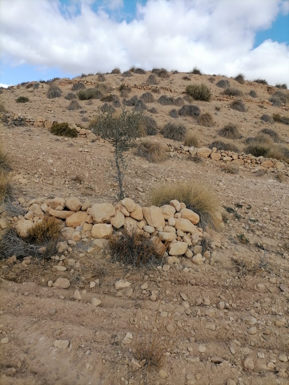
Stone lines (or "stone barriers") are small structures aligned along contours. These reduce the velocity of runoff flowing down sloping land while capturing materials carried by the water. The stone lines gradually accumulate sediment which leads to the gradual creation of terraces.
2.2 Detailed description of the Technology
Description:
Stone lines (or "stone barriers") comprise a traditional soil and water conservation technique that has been used for centuries in Tunisia. These structures serve the dual purpose of slowing down rainwater runoff on sloping terrain and retaining suspended materials carried by the water.
On moderately rocky slopes, stone lines are established along the contour. Behind these barriers, sediment gradually accumulates through the effects of runoff, wind, and tillage, creating an environment conducive to the growth of trees - such as olives, almonds, or forest varieties - and fodder shrubs.
When established, the lines should have an upstream inclination of approximately 10%. The maximum height of the lines should be between 60 and 100 cm, with the downstream face sloping forwards. The spacing between two lines is determined by the slope of the terrain, calculated carefully to prevent the impact of heavy rainfall and associated runoff. It is not advisable to install stone lines on marly, clayey, or sandy soils lacking cohesion.
Commonly, before the lines are built, subsoiling work is carried out along the contour. Maintenance is crucial for the longevity of these structures, necessitating increasing the height of the structures as they accumulated sediment. One line should not exceed 500 meters.
They provide a habitat for a variety of plant and animal species, fostering biodiversity and enhancing ecosystem services. Installing and maintaining these dry stone structures involves employing local knowledge, skills, and materials, encouraging community engagement and self-sufficiency – all of which are fundamental principles of agroecology.
Land users value this technology for its many benefits and contributions to sustainable land and water management.
2.3 Photos of the Technology
Media Gallery
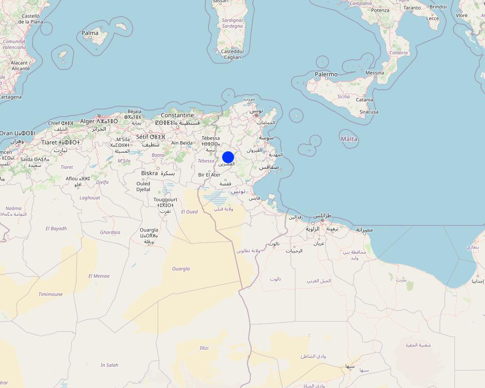
2.5 Country/ region/ locations where the Technology has been applied and which are covered by this assessment
Country:
Tunisia
Region/ State/ Province:
Kasserine
Further specification of location:
Bouzgam
Specify the spread of the Technology:
- evenly spread over an area
If precise area is not known, indicate approximate area covered:
- 1-10 km2
Is/are the technology site(s) located in a permanently protected area?
No
Map
×2.6 Date of implementation
Indicate year of implementation:
2017
2.7 Introduction of the Technology
Specify how the Technology was introduced:
- as part of a traditional system (> 50 years)
- through projects/ external interventions
3. Classification of the SLM Technology
3.1 Main purpose(s) of the Technology
- reduce, prevent, restore land degradation
- conserve ecosystem
- protect a watershed/ downstream areas – in combination with other Technologies
- adapt to climate change/ extremes and its impacts
- create beneficial economic impact
3.2 Current land use type(s) where the Technology is applied
Land use mixed within the same land unit:
Yes
Specify mixed land use (crops/ grazing/ trees):
- Agroforestry
3.3 Has land use changed due to the implementation of the Technology?
Has land use changed due to the implementation of the Technology?
- No (Continue with question 3.4)
3.4 Water supply
Water supply for the land on which the Technology is applied:
- rainfed
3.5 SLM group to which the Technology belongs
- agroforestry
- cross-slope measure
3.6 SLM measures comprising the Technology

structural measures
- S2: Bunds, banks
3.7 Main types of land degradation addressed by the Technology

soil erosion by water
- Wt: loss of topsoil/ surface erosion
3.8 Prevention, reduction, or restoration of land degradation
Specify the goal of the Technology with regard to land degradation:
- prevent land degradation
- reduce land degradation
4. Technical specifications, implementation activities, inputs, and costs
4.1 Technical drawing of the Technology
Technical specifications (related to technical drawing):
S: Top from 0.4 to 0.5 m
H: Height from 0.4 to 1 m
L: Width from 0.8 to 1.2 m
E: Distance between two cordons depending on the slope. This distance can be calculated using Bugeat's formula for the distance between benches: E=2.2/P+8, where E is the distance between the beads in m and P is the slope in %.
Author:
Wafa SAIDI
4.2 General information regarding the calculation of inputs and costs
Indicate average wage cost of hired labour per day:
25
4.3 Establishment activities
| Activity | Timing (season) | |
|---|---|---|
| 1. | Stone collection and delivery | |
| 2. | Excavation of a 30 cm wide and 50 cm high trench | |
| 3. | Construction of cordons |
4.4 Costs and inputs needed for establishment
| Specify input | Unit | Quantity | Costs per Unit | Total costs per input | % of costs borne by land users | |
|---|---|---|---|---|---|---|
| Labour | Workers | m | ||||
| Construction material | Dry stones | m | ||||
| Other | Transportation | m | ||||
| Other | Other loads | m |
If land user bore less than 100% of costs, indicate who covered the remaining costs:
Directorate-General for the Development and Conservation of Agricultural Lands
Comments:
Stone lines are generally built using stones available on the surface.
4.5 Maintenance/ recurrent activities
| Activity | Timing/ frequency | |
|---|---|---|
| 1. | Raising of the cordon |
4.6 Costs and inputs needed for maintenance/ recurrent activities (per year)
| Specify input | Unit | Quantity | Costs per Unit | Total costs per input | % of costs borne by land users | |
|---|---|---|---|---|---|---|
| Labour | Workers | m |
Comments:
Workforce for the collection and installation of the stones.
4.7 Most important factors affecting the costs
Describe the most determinate factors affecting the costs:
- Availability of workers
- Availability of dry stones
5. Natural and human environment
5.1 Climate
Annual rainfall
- < 250 mm
- 251-500 mm
- 501-750 mm
- 751-1,000 mm
- 1,001-1,500 mm
- 1,501-2,000 mm
- 2,001-3,000 mm
- 3,001-4,000 mm
- > 4,000 mm
Specify average annual rainfall (if known), in mm:
250.00
Specifications/ comments on rainfall:
Rainfall exhibits considerable variability both seasonally and annually. The shoulder seasons, autumn and spring, are characterized by the highest precipitation levels, featuring frequent showers.
Indicate the name of the reference meteorological station considered:
Kasserine
Agro-climatic zone
- arid
Winter temperatures are low, while summer temperatures are high, displaying a significant degree of irregularity.
5.2 Topography
Slopes on average:
- flat (0-2%)
- gentle (3-5%)
- moderate (6-10%)
- rolling (11-15%)
- hilly (16-30%)
- steep (31-60%)
- very steep (>60%)
Landforms:
- plateau/plains
- ridges
- mountain slopes
- hill slopes
- footslopes
- valley floors
Altitudinal zone:
- 0-100 m a.s.l.
- 101-500 m a.s.l.
- 501-1,000 m a.s.l.
- 1,001-1,500 m a.s.l.
- 1,501-2,000 m a.s.l.
- 2,001-2,500 m a.s.l.
- 2,501-3,000 m a.s.l.
- 3,001-4,000 m a.s.l.
- > 4,000 m a.s.l.
5.3 Soils
Soil depth on average:
- very shallow (0-20 cm)
- shallow (21-50 cm)
- moderately deep (51-80 cm)
- deep (81-120 cm)
- very deep (> 120 cm)
Soil texture (topsoil):
- coarse/ light (sandy)
- medium (loamy, silty)
Soil texture (> 20 cm below surface):
- coarse/ light (sandy)
- medium (loamy, silty)
Topsoil organic matter:
- low (<1%)
If available, attach full soil description or specify the available information, e.g. soil type, soil PH/ acidity, Cation Exchange Capacity, nitrogen, salinity etc.
Organic carbon in topsoil (% by weight): 1
Topsoil pH (H2O): 8
Calcium carbonate in topsoil (% by weight): 43.4
Topsoil gypsum (% by weight): 0.2
Topsoil sodicity of(ESP) (%): 5
Topsoil salinity (ECe) (dS/m): 1
Subsoil organic carbon (wt%): 0.35
Subsoil pH (H2O): 8.3
Subsoil calcium carbonate (wt%): 62.7
Subsoil gypsum (% weight): 0.3
Subsoil sodicity (ESP) (%): 12
5.4 Water availability and quality
Ground water table:
> 50 m
Availability of surface water:
medium
Water quality (untreated):
for agricultural use only (irrigation)
Water quality refers to:
both ground and surface water
Is water salinity a problem?
No
Is flooding of the area occurring?
Yes
Regularity:
episodically
5.5 Biodiversity
Species diversity:
- medium
Habitat diversity:
- medium
5.6 Characteristics of land users applying the Technology
Sedentary or nomadic:
- Sedentary
Market orientation of production system:
- mixed (subsistence/ commercial)
Off-farm income:
- less than 10% of all income
- 10-50% of all income
Relative level of wealth:
- average
- rich
Individuals or groups:
- individual/ household
Level of mechanization:
- mechanized/ motorized
Gender:
- men
Age of land users:
- youth
- middle-aged
5.7 Average area of land used by land users applying the Technology
- < 0.5 ha
- 0.5-1 ha
- 1-2 ha
- 2-5 ha
- 5-15 ha
- 15-50 ha
- 50-100 ha
- 100-500 ha
- 500-1,000 ha
- 1,000-10,000 ha
- > 10,000 ha
Is this considered small-, medium- or large-scale (referring to local context)?
- medium-scale
- large-scale
5.8 Land ownership, land use rights, and water use rights
Land ownership:
- individual, titled
Land use rights:
- individual
Water use rights:
- individual
Are land use rights based on a traditional legal system?
No
5.9 Access to services and infrastructure
health:
- poor
- moderate
- good
education:
- poor
- moderate
- good
technical assistance:
- poor
- moderate
- good
employment (e.g. off-farm):
- poor
- moderate
- good
markets:
- poor
- moderate
- good
energy:
- poor
- moderate
- good
roads and transport:
- poor
- moderate
- good
drinking water and sanitation:
- poor
- moderate
- good
financial services:
- poor
- moderate
- good
6. Impacts and concluding statements
6.1 On-site impacts the Technology has shown
Socio-economic impacts
Production
crop production
Comments/ specify:
Stone lines protect farmlands from degradation, thereby ensuring their productivity. They improve agricultural production by more than 50%.
crop quality
fodder production
Comments/ specify:
They contribute to increased forage availability.
risk of production failure
production area
Comments/ specify:
Stone lines help transform sloping or undulating terrain into flat or gently sloping surfaces, making the land more suitable for cultivation.
Income and costs
expenses on agricultural inputs
farm income
Socio-cultural impacts
food security/ self-sufficiency
SLM/ land degradation knowledge
Ecological impacts
Water cycle/ runoff
water quantity
Comments/ specify:
They are used to capture and retain rainwater.
harvesting/ collection of water
surface runoff
Comments/ specify:
Stone lines play a role in reducing water runoff by 50%.
Soil
soil moisture
Comments/ specify:
They prevent excessive moisture loss and contribute to improved soil moisture retention.
soil cover
soil loss
soil accumulation
soil organic matter/ below ground C
Biodiversity: vegetation, animals
biomass/ above ground C
Climate and disaster risk reduction
flood impacts
drought impacts
impacts of cyclones, rain storms
Specify assessment of on-site impacts (measurements):
These are based on estimates from local farmers
6.2 Off-site impacts the Technology has shown
water availability
Comments/ specify:
Stone lines contribute to increased infiltration of rainwater into the soil, thereby replenishing water resources.
downstream flooding
Comments/ specify:
Stone lines and walls reduce peak flows during heavy rainfall and minimize the risk of flooding.
downstream siltation
groundwater/ river pollution
Comments/ specify:
By mitigating sediment and pollutant runoff, stone barriers help maintain or restore water quality in rivers.
Specify assessment of off-site impacts (measurements):
These are estimates made by farmers and observations made by researchers and experts.
6.3 Exposure and sensitivity of the Technology to gradual climate change and climate-related extremes/ disasters (as perceived by land users)
Gradual climate change
Gradual climate change
| Season | increase or decrease | How does the Technology cope with it? | |
|---|---|---|---|
| seasonal temperature | summer | increase | moderately |
| seasonal rainfall | wet/ rainy season | decrease | well |
| other gradual climate change | Rainfall intensity | increase | very well |
Climate-related extremes (disasters)
Climatological disasters
| How does the Technology cope with it? | |
|---|---|
| drought | well |
Hydrological disasters
| How does the Technology cope with it? | |
|---|---|
| general (river) flood | well |
| landslide | well |
6.4 Cost-benefit analysis
How do the benefits compare with the establishment costs (from land users’ perspective)?
Short-term returns:
very positive
Long-term returns:
very positive
How do the benefits compare with the maintenance/ recurrent costs (from land users' perspective)?
Short-term returns:
very positive
Long-term returns:
very positive
6.5 Adoption of the Technology
- > 50%
Of all those who have adopted the Technology, how many did so spontaneously, i.e. without receiving any material incentives/ payments?
- 11-50%
6.6 Adaptation
Has the Technology been modified recently to adapt to changing conditions?
No
6.7 Strengths/ advantages/ opportunities of the Technology
| Strengths/ advantages/ opportunities in the land user’s view |
|---|
| Protection against water erosion |
| Increased agricultural productivity |
| Strengths/ advantages/ opportunities in the compiler’s or other key resource person’s view |
|---|
| Stone barriers are a sustainable solution for controlling soil erosion. Once built, they require minimal maintenance and have a lifespan of several decades. This long-term durability reduces the need for frequent intervention and investment. |
| Stone barriers help to mitigate the impacts of climate change by reducing soil erosion and improving water availability. They help to make farming systems more resilient to extreme weather events, such as heavy rain and drought, which are becoming more frequent and intense as a result of climate change. |
| Stone barriers are in line with the principles of sustainable land management. They help conserve soil and water resources, support sustainable farming practices, and contribute to the ecological balance of the entire region. |
6.8 Weaknesses/ disadvantages/ risks of the Technology and ways of overcoming them
| Weaknesses/ disadvantages/ risks in the land user’s view | How can they be overcome? |
|---|---|
| Installing stone lines is a costly operation for small-scale farmers. | Facilitate the procedures for accessing the Special Agricultural Development Fund and overcome the ceiling on subsidies allocated to water and soil conservation actions. |
| Land fragmentation is a constraint when installing dry stones. | Coordinated efforts among neighboring farmers have led to the establishment of a network of dry-stone cordons. |
| Weaknesses/ disadvantages/ risks in the compiler’s or other key resource person’s view | How can they be overcome? |
|---|---|
| The stone lines may not be as effective during extreme weather events such as very heavy rains or violent storms, which can damage or erode the cordons. | Consolidate dry-stone cordons with pasture and forage plantations to improve their stability and efficiency in extreme conditions, and compensate farmers for lost income. |
7. References and links
7.1 Methods/ sources of information
- field visits, field surveys
A visit to the Bouzguem area in Kasserine
- interviews with land users
3 farmers were interviewed.
- interviews with SLM specialists/ experts
- compilation from reports and other existing documentation
When were the data compiled (in the field)?
31/01/2023
7.2 References to available publications
Title, author, year, ISBN:
Guide de conservation des eaux et du Sol, Ministère de l’agriculture, Direction Générale de l'Aménagement et de la Conservations des Terres Agricoles, 1995: Ministère de l’agriculture, Direction Générale de l'Aménagement et de la Conservations des Terres Agricoles
Available from where? Costs?
Directorate-General for the Development and Conservation of Agricultural Lands, 1995: Ministry of Agriculture
Title, author, year, ISBN:
Carte agricole de la Tunisie, Ministère de l’agriculture, 2005
Available from where? Costs?
Ministry of Agriculture, Directorate-General for the Development and Conservation of Agricultural Lands
7.3 Links to relevant online information
Title/ description:
Guide des bonnes pratiques d'utilisation durable de l'eau et des terres, WWF, 2019
URL:
https://www.wwf.ma/nos_nouvelles/nospublications/?33164/Guide-des-bonnes-pratiques-dutilisation-durable-de-leau-et-des-terres
Title/ description:
Guide technique pour la lutte contre la désertification, Abdessalem Kallala, OSS, 2017
URL:
http://projet.oss-online.org/LCD/images/BP/Techniques_LCD.pdf
Title/ description:
Harmonized World Soil Database, FAO, 2009
URL:
https://www.fao.org/soils-portal/data-hub/soil-maps-and-databases/harmonized-world-soil-database-v12/en/
Links and modules
Expand all Collapse allLinks
No links
Modules
No modules