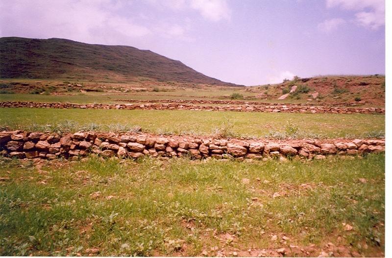
Stone faced soil bund of Tigray [Ethiopia]
- Creation:
- Update:
- Compiler: Unknown User
- Editor: –
- Reviewers: Fabian Ottiger, Alexandra Gavilano
Emni Getsu hamed zala
technologies_980 - Ethiopia
View sections
Expand all Collapse all1. General information
1.2 Contact details of resource persons and institutions involved in the assessment and documentation of the Technology
Key resource person(s)
SLM specialist:
Tesfaye Tadele
S/Samre office of Agriculture and Natural Resources
Ethiopia
1.3 Conditions regarding the use of data documented through WOCAT
The compiler and key resource person(s) accept the conditions regarding the use of data documented through WOCAT:
Yes
2. Description of the SLM Technology
2.1 Short description of the Technology
Definition of the Technology:
Stone walls placed downslope in an inclined manner having embankment of soil on upstream along the contour line having tieridge.
2.2 Detailed description of the Technology
Description:
Description: Along the contour 30 cm width and 420 cm depth of foundation is excavated and stones are cplaced upto a height of 0.5-0.75 with 1 m width and 30 cm top width. On the uper side embankment soil is added and a basin with 5-10 m tie is excavated. Purpose: To reduce soil erosion, shorten slope length and retain soil moisture. Establishment/Maintenance: Integrate with biological SWC activities, Farmers maintain Environment: Enhance vegetation growth, improve micro-climate, decrease land degradation
2.3 Photos of the Technology
Media Gallery
2.5 Country/ region/ locations where the Technology has been applied and which are covered by this assessment
Country:
Ethiopia
Region/ State/ Province:
Tigray
Further specification of location:
Woreda
Comments:
Total area covered by the SLM Technology is 327.53 km2.
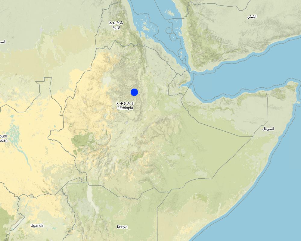
Map
×2.6 Date of implementation
If precise year is not known, indicate approximate date:
- less than 10 years ago (recently)
2.7 Introduction of the Technology
Specify how the Technology was introduced:
- through projects/ external interventions
3. Classification of the SLM Technology
3.2 Current land use type(s) where the Technology is applied

Cropland
- Annual cropping
- Tree and shrub cropping
Annual cropping - Specify crops:
- cereals - barley
- cereals - sorghum
- legumes and pulses - beans
- oilseed crops - sunflower, rapeseed, other
- teff, horse bean
- Leucanea, sasbanea
Number of growing seasons per year:
- 1
Specify:
Longest growing period in days: 150 Longest growing period from month to month: Jul - Dec Second longest growing period in days: 120 Second longest growing period from month to month: Jun - Oct
Is intercropping practiced?
Yes
If yes, specify which crops are intercropped:
Teff and sun flower

Grazing land
- Free grazing
Comments:
Major land use problems (compiler’s opinion): Soil erosion, deforestation, overgrazing, decline of fertility, low moisture holding capacity
Major land use problems (land users’ perception): Low productivity, low rainfall, soil erosion, deforestation
3.4 Water supply
Water supply for the land on which the Technology is applied:
- rainfed
Comments:
Water supply: Also rainfed, mixed rainfed - irrigated
Water supply: post-flooding
3.5 SLM group to which the Technology belongs
- cross-slope measure
3.6 SLM measures comprising the Technology
3.7 Main types of land degradation addressed by the Technology

soil erosion by water
- Wt: loss of topsoil/ surface erosion
- Wg: gully erosion/ gullying
- Wr: riverbank erosion
Comments:
Main type of degradation addressed: Wt: loss of topsoil / surface erosion, Wg: gully erosion / gullying
Secondary types of degradation addressed: Wr: riverbank erosion
3.8 Prevention, reduction, or restoration of land degradation
Specify the goal of the Technology with regard to land degradation:
- prevent land degradation
- reduce land degradation
Comments:
Secondary goals: rehabilitation / reclamation of denuded land
4. Technical specifications, implementation activities, inputs, and costs
4.1 Technical drawing of the Technology
Technical specifications (related to technical drawing):
Technical knowledge required for field staff / advisors: high
Technical knowledge required for land users: moderate
Main technical functions: control of dispersed runoff: retain / trap, control of dispersed runoff: impede / retard, control of concentrated runoff: retain / trap, reduction of slope angle, reduction of slope length, increase of infiltration
Mixed cropping / intercropping
Material/ species: Teff and sun flower
Remarks: direct sowing
Aligned: -contour
Vegetative material: T : trees / shrubs, G : grass
Number of plants per (ha): 1000/ha
Vertical interval between rows / strips / blocks (m): 1
Spacing between rows / strips / blocks (m): 15-20
Vertical interval within rows / strips / blocks (m): 0.5-1
Trees/ shrubs species: Leucanea, sasbanea
Grass species: local grasses
Slope (which determines the spacing indicated above): 12.00%
If the original slope has changed as a result of the Technology, the slope today is (see figure below): 3.00%
Bund/ bank: level
Vertical interval between structures (m): 1
Spacing between structures (m): 60-80m
Depth of ditches/pits/dams (m): 0.1m
Width of ditches/pits/dams (m): 0.5m
Height of bunds/banks/others (m): 0.5-0.75mm
Width of bunds/banks/others (m): 1m
Length of bunds/banks/others (m): 60-80m
Construction material (earth): none clay and sandy soils
Construction material (stone): medium sized stone
Slope (which determines the spacing indicated above): 12%
Vegetation is used for stabilisation of structures.
4.2 General information regarding the calculation of inputs and costs
other/ national currency (specify):
Birr
If relevant, indicate exchange rate from USD to local currency (e.g. 1 USD = 79.9 Brazilian Real): 1 USD =:
8.6
Indicate average wage cost of hired labour per day:
0.88
4.3 Establishment activities
| Activity | Timing (season) | |
|---|---|---|
| 1. | Seedling production | Dec-June |
| 2. | Pitting | May |
| 3. | Planting | July |
| 4. | Survey & layout | January |
| 5. | Fundation excavation | February-April |
| 6. | Stone collection | February-April |
| 7. | Construction and digging the basin and put the soil at the upper side of the bund | February-April |
| 8. | Forming farmers groups | |
| 9. | Discussion among group members | |
| 10. | Plan of activities | |
| 11. | Implementation of measures | |
| 12. | Guarding |
4.4 Costs and inputs needed for establishment
| Specify input | Unit | Quantity | Costs per Unit | Total costs per input | % of costs borne by land users | |
|---|---|---|---|---|---|---|
| Labour | Labour | ha | 1.0 | 109.4 | 109.4 | 100.0 |
| Equipment | Tools | ha | 1.0 | 10.0 | 10.0 | 100.0 |
| Plant material | Seeds | ha | 1.0 | 9.4 | 9.4 | 100.0 |
| Plant material | Fertilizer | ha | 1.0 | 33.75 | 33.75 | 100.0 |
| Other | Person days | ha | 1.0 | 66.9 | 66.9 | 100.0 |
| Total costs for establishment of the Technology | 229.45 | |||||
| Total costs for establishment of the Technology in USD | 26.68 | |||||
Comments:
Duration of establishment phase: 60 month(s)
4.5 Maintenance/ recurrent activities
| Activity | Timing/ frequency | |
|---|---|---|
| 1. | Contour plowing | April-may / 3 times |
| 2. | Enrichment planting | August /annual |
| 3. | Weeding and cultivating | September /annual |
| 4. | Stone collection | January/annual |
| 5. | Construction | January/annual |
| 6. | Planting/replanting | |
| 7. | Implementing water harvesting measures |
4.6 Costs and inputs needed for maintenance/ recurrent activities (per year)
| Specify input | Unit | Quantity | Costs per Unit | Total costs per input | % of costs borne by land users | |
|---|---|---|---|---|---|---|
| Labour | Labour | ha | 1.0 | 10.9 | 10.9 | 100.0 |
| Total costs for maintenance of the Technology | 10.9 | |||||
| Total costs for maintenance of the Technology in USD | 1.27 | |||||
Comments:
Length of structure and number of seedlings
4.7 Most important factors affecting the costs
Describe the most determinate factors affecting the costs:
steep slope, transport for construction materials (stone), dry soils (land), shallow soils.
5. Natural and human environment
5.1 Climate
Annual rainfall
- < 250 mm
- 251-500 mm
- 501-750 mm
- 751-1,000 mm
- 1,001-1,500 mm
- 1,501-2,000 mm
- 2,001-3,000 mm
- 3,001-4,000 mm
- > 4,000 mm
Agro-climatic zone
- sub-humid
- semi-arid
5.2 Topography
Slopes on average:
- flat (0-2%)
- gentle (3-5%)
- moderate (6-10%)
- rolling (11-15%)
- hilly (16-30%)
- steep (31-60%)
- very steep (>60%)
Landforms:
- plateau/plains
- ridges
- mountain slopes
- hill slopes
- footslopes
- valley floors
Altitudinal zone:
- 0-100 m a.s.l.
- 101-500 m a.s.l.
- 501-1,000 m a.s.l.
- 1,001-1,500 m a.s.l.
- 1,501-2,000 m a.s.l.
- 2,001-2,500 m a.s.l.
- 2,501-3,000 m a.s.l.
- 3,001-4,000 m a.s.l.
- > 4,000 m a.s.l.
Comments and further specifications on topography:
Altitudinal zone: 1000-2500 m a.s.l.
Landforms: Also mountain- and hill slopes
Slopes on average: Also hilly and moderate
5.3 Soils
Soil depth on average:
- very shallow (0-20 cm)
- shallow (21-50 cm)
- moderately deep (51-80 cm)
- deep (81-120 cm)
- very deep (> 120 cm)
Soil texture (topsoil):
- coarse/ light (sandy)
Topsoil organic matter:
- low (<1%)
If available, attach full soil description or specify the available information, e.g. soil type, soil PH/ acidity, Cation Exchange Capacity, nitrogen, salinity etc.
Soil texture: Also medium (ranked 2) and fine/heavy (ranked 3)
Soil fertility is low-medium
Soil drainage/infiltration is good-poor
Soil water storage capacity is low-high
5.6 Characteristics of land users applying the Technology
Market orientation of production system:
- subsistence (self-supply)
Off-farm income:
- less than 10% of all income
Relative level of wealth:
- very poor
- poor
Level of mechanization:
- manual work
- animal traction
Indicate other relevant characteristics of the land users:
Population density: 50-100 persons/km2
Annual population growth: 2% - 3%; 3%
80% of the land users are average wealthy and own 80% of the land.
15% of the land users are poor and own 15% of the land.
5% of the land users are poor and own 5% of the land.
Off-farm income specification: Employed as daily labourer for weeding, plowing and harvesting.
Market orientation is subsistence (the area is drought prone and production is very low)
5.7 Average area of land used by land users applying the Technology
- < 0.5 ha
- 0.5-1 ha
- 1-2 ha
- 2-5 ha
- 5-15 ha
- 15-50 ha
- 50-100 ha
- 100-500 ha
- 500-1,000 ha
- 1,000-10,000 ha
- > 10,000 ha
Comments:
0.5-1ha for both grazing and cropland per household. Average land holding size is 0.5 ha
5.8 Land ownership, land use rights, and water use rights
Land ownership:
- state
6. Impacts and concluding statements
6.1 On-site impacts the Technology has shown
Socio-economic impacts
Production
crop production
Comments/ specify:
200 kg
fodder production
fodder quality
wood production
production area
Comments/ specify:
Space taken by structure is small
land management
Income and costs
farm income
Socio-cultural impacts
community institutions
SLM/ land degradation knowledge
Ecological impacts
Water cycle/ runoff
excess water drainage
Soil
soil moisture
soil cover
soil loss
Biodiversity: vegetation, animals
pest/ disease control
Comments/ specify:
If proper placing of stone not followed
Other ecological impacts
Biodiversity
Soil fertility
Enriching ground water
Risk of damage on properties if the structure breaks
Waterlogging
Comments/ specify:
in clay soils during wet seasons it is high
6.2 Off-site impacts the Technology has shown
reliable and stable stream flows in dry season
downstream flooding
downstream siltation
Comments/ specify:
decreasing siltation of dam and cultivated area
6.4 Cost-benefit analysis
How do the benefits compare with the establishment costs (from land users’ perspective)?
Short-term returns:
positive
Long-term returns:
positive
How do the benefits compare with the maintenance/ recurrent costs (from land users' perspective)?
Short-term returns:
very positive
Long-term returns:
positive
6.5 Adoption of the Technology
Of all those who have adopted the Technology, how many did so spontaneously, i.e. without receiving any material incentives/ payments?
- 91-100%
Comments:
100% of land user families have adopted the Technology without any external material support
98328 land user families have adopted the Technology without any external material support
There is a little trend towards spontaneous adoption of the Technology
Comments on adoption trend: Especially the maintenance of the structure is done by individuals holding the land
6.7 Strengths/ advantages/ opportunities of the Technology
| Strengths/ advantages/ opportunities in the land user’s view |
|---|
|
Increase production How can they be sustained / enhanced? Cut and carry, area closure, Integrating physical SWC measures with biological SWC measures. |
|
Availability of water near byareas How can they be sustained / enhanced? Water harvesting structures and practices |
|
Animal feed increased How can they be sustained / enhanced? Planting fodder trees and grasses |
| Strengths/ advantages/ opportunities in the compiler’s or other key resource person’s view |
|---|
|
It conserves soil How can they be sustained / enhanced? The work has to be continued in organized way. |
|
It conserves moisture How can they be sustained / enhanced? Include contour cultivation and other methods enhancing the soil moisture build up. |
|
Increase production How can they be sustained / enhanced? Integration of biological measures use of manure and other fertility improving measures. |
|
Enhancing spring development How can they be sustained / enhanced? Practice more water retaining measures upslopes |
6.8 Weaknesses/ disadvantages/ risks of the Technology and ways of overcoming them
| Weaknesses/ disadvantages/ risks in the land user’s view | How can they be overcome? |
|---|---|
| It reduces cultivated land | Make the land productive by integrating with biological SWC measures, planting grass on the bund |
| It creates problem in farm activities | Design the structure in such a way that it can not create problem for farming. |
| Weaknesses/ disadvantages/ risks in the compiler’s or other key resource person’s view | How can they be overcome? |
|---|---|
| It takes land | By integrating with biological measures make the land productive. |
| In some places hinder farm operation | Increase width of cultivable strips |
7. References and links
7.1 Methods/ sources of information
Links and modules
Expand all Collapse allLinks
No links
Modules
No modules