Water harvesting from concentrated runoff for irrigation purposes [España]
- Creación:
- Actualización:
- Compilador: Joris De Vente
- Editor: –
- Revisores: Deborah Niggli, Alexandra Gavilano
Boqueras (Spanish)
technologies_1517 - España
- Resumen completo en PDF
- Resumen completo en PDF para imprimir
- Resumen completo en el navegador
- Resumen completo (sin formato)
- Water harvesting from concentrated runoff for irrigation purposes: 23 de julio de 2019 (public)
- Water harvesting from concentrated runoff for irrigation purposes: 4 de abril de 2018 (inactive)
- Water harvesting from concentrated runoff for irrigation purposes: 4 de abril de 2018 (inactive)
- Water harvesting from concentrated runoff for irrigation purposes: 5 de agosto de 2017 (inactive)
- Water harvesting from concentrated runoff for irrigation purposes: 14 de marzo de 2017 (inactive)
Visualizar secciones
Expandir todo Colapsar todos1. Información general
1.2 Detalles de contacto de las personas de referencia e instituciones involucradas en la evaluación y la documentación de la Tecnología
Especialista MST:
Especialista MST:
López Carratala Jorge
Consejo Superior de Investigaciones Científicas, Estación Experimental de Zonas Áridas (EEZA-CSIC)
España
Especialista MST:
Ibáñez Torres Ascensión
Consejería de Agricultura y Agua Murcia (CARM)
España
usuario de la tierra:
Escamez Antonio
España
Especialista MST:
Researcher Université Catholique de Lovain (UCL)
Bélgica
Nombre del proyecto que financió la documentación/ evaluación de la Tecnología (si fuera relevante)
DESIRE (EU-DES!RE)Nombre del proyecto que financió la documentación/ evaluación de la Tecnología (si fuera relevante)
Book project: Water Harvesting – Guidelines to Good Practice (Water Harvesting)Nombre de la(s) institución(es) que facilitaron la documentación/ evaluación de la Tecnología (si fuera relevante)
EEZA-CSIC (EEZA-CSIC) - EspañaNombre de la(s) institución(es) que facilitaron la documentación/ evaluación de la Tecnología (si fuera relevante)
Consejería de Agricultura y Agua Murcia (CARM) - España1.3 Condiciones referidas al uso de datos documentados mediante WOCAT
El compilador y la/s persona(s) de referencia claves aceptan las condiciones acerca del uso de los datos documentados mediante WOCAT:
Sí
2. Descripción de la Tecnología MST
2.1 Breve descripción de la Tecnología
Definición de la Tecnología:
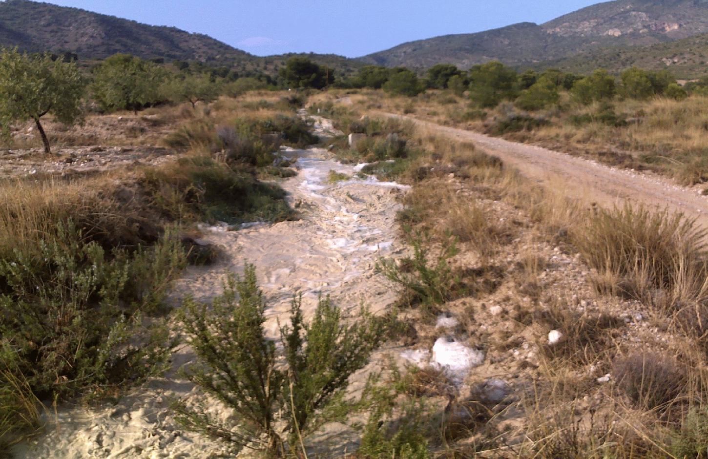
Water harvesting from intermittent streams towards nearby fields and terraces during runoff events.
2.2 Descripción detallada de la Tecnología
Descripción:
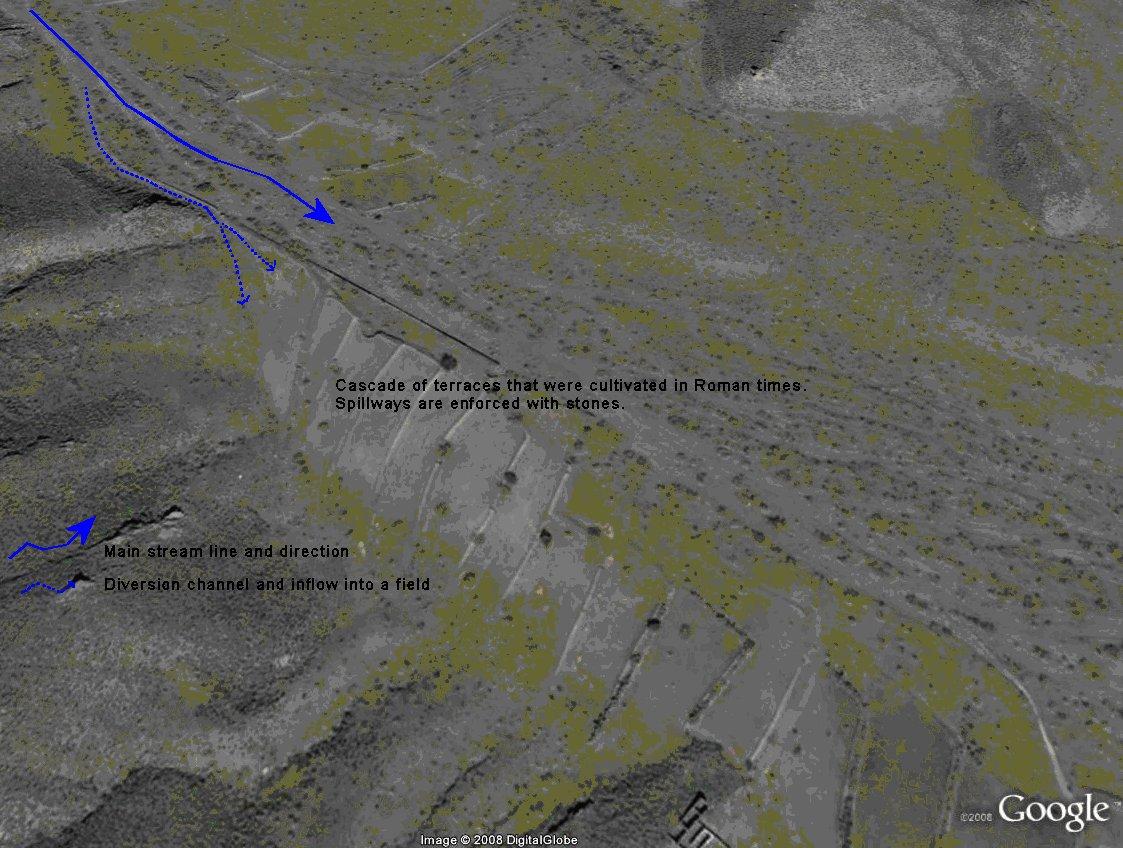
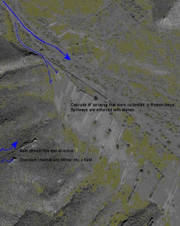
Water shortage is one of the most limiting factors for sustainable agriculture in large parts of SE-Spain. Part of the solution of this problem may come from the restoration of traditional water harvesting structures. Many of these structures were widely used in SE-Spain already during Arab and Roman times, and are also widespread in N-Africa and the Middle East. However, nowadays in Spain many of them are abandoned and forgotten. Here, we describe the technology of a small earthen- or stone- built bund that diverts flood water from intermittent streams towards cultivated fields with almond orchards and/or cereals. The diverted water will temporarily flood the fields and provide the crops with water. Depending on the slope gradient and the amount of water to be harvested, the fields are organised as single terraces, or as a staircase of terraces. On fields with gradients above ~3%, terraces are necessary to reduce the gradient and to retain the floodwater as long as possible. Water is diverted from one terrace to the next through small spillways in the terrace. The spillways can best be fortified with stones to prevent bank gully formation. The extra input of surface water can double the almond yield. The use of these water harvesting structures is only possible under certain environmental and topographic conditions. The cultivated fields should be at a relatively short distance from an intermittent stream (<~50m), and the stream should have a sufficiently large upstream contributing area to provide significant amounts of runoff water during rainfall events. With these systems, water can be harvested up to 8 times per year, mostly in spring and autumn during high intensity rainfall events. A well designed Boquera system may provide up to 550 mm of additional water, in areas with an average annual rainfall of 300 m.
Purpose of the Technology: The goal of this technology is to increase crop yield. In addition, these structures help to reduce the intensity of floods and reduce the damage caused by them by reducing runoff volume in intermittent streams.
Establishment / maintenance activities and inputs: Water harvesting requires the identification of a suitable location for the construction of a diversion structure. This requires assessment of expected water inflow, which can usually be based on simple field observation during rainfall events and based on local knowledge of land users. It is, however, important to consider whether there are activities upstream that possibly affect the water quality (e.g. farm animals) and to assess the implications the water harvesting might have downstream. Permission is required from the water authorities to construct any type of water harvesting structure. Such structures are built by creating a small bund (<1m height) in the centre or to the side of a stream. Depending on the size, the bund can be built with a shovel or a tractor. The water harvesting structure will require control and some maintenance after each important runoff event. When strengthened with concrete, maintenance will be reduced to approximately once every 5 years.
Natural / human environment: Soils are mostly of shallow to medium depth (20-60 cm), and slopes are gentle to moderate (5-15%). The climate is semi-arid with a mean annual rainfall around 300 mm. Droughts, centred in summer commonly last for more than 4-5 months. Annual potential evapotranspiration rates larger than 1000 mm are common.
2.3 Fotografías de la Tecnología
Galería de medios
2.5 País/ región/ lugares donde la Tecnología fue aplicada y que se hallan comprendidos por esta evaluación
País:
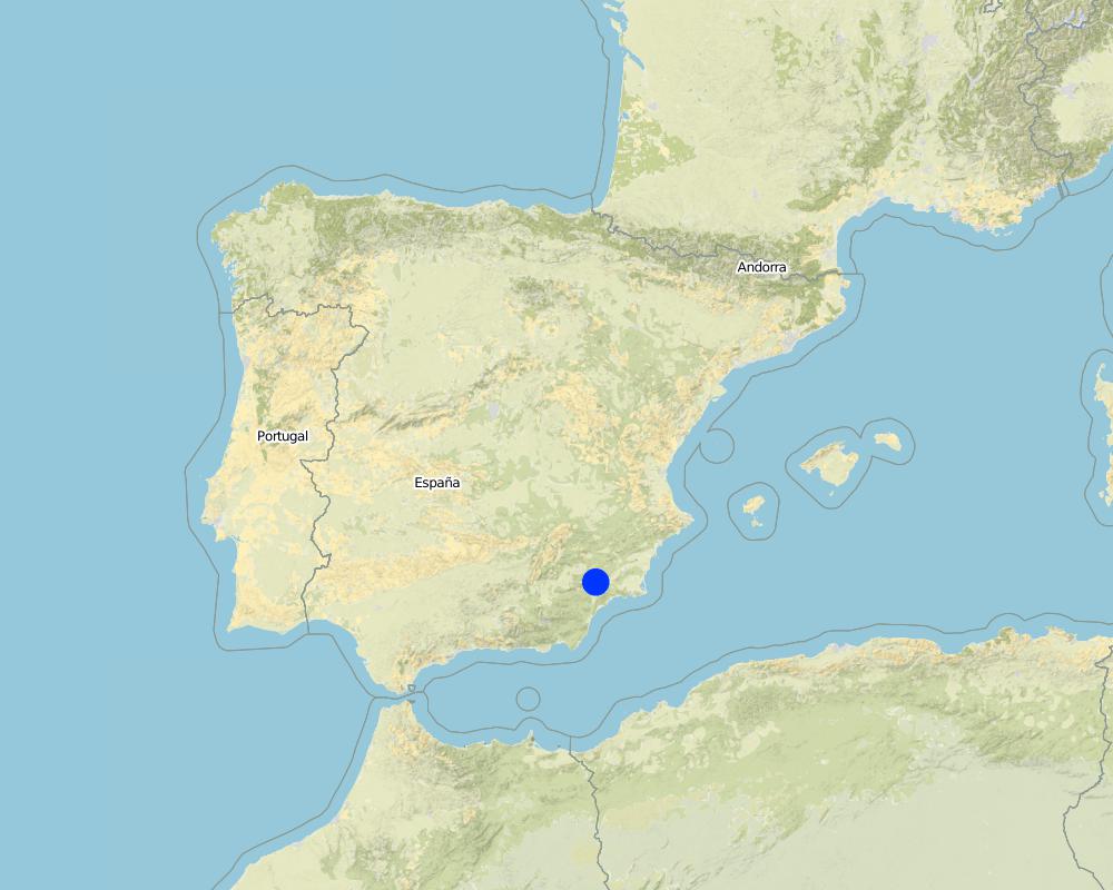
España
Región/ Estado/ Provincia:
Murcia
Especifique más el lugar :
Guadalentin catchment
Especifique la difusión de la Tecnología:
- distribuida parejamente sobre un área
Si se desconoce el área precisa, indique el área aproximada cubierta:
- < 0.1 km2 (10 ha)
Map
×2.6 Fecha de la implementación
Si no se conoce el año preciso, indique la fecha aproximada:
- hace más de 50 años atrás (tradicional)
2.7 Introducción de la Tecnología
Especifique cómo se introdujo la Tecnología:
- como parte de un sistema tradicional (> 50 años)
Comentarios (tipo de proyecto, etc.):
Most of the water harvesting structures are already much older than 50 years and originate even from Roman or Arab times.
3. Clasificación de la Tecnología MST
3.2 Tipo(s) actuales de uso de la tierra donde se aplica la Tecnología
Mezcla de tipos de uso de tierras dentro de la misma unidad de tierras: :
Sí
Especifique el uso combinado de tierras (cultivos/ pastoreo/ árboles):
- Agroforestería

Tierras cultivadas
- Cosecha anual
- Cosecha de árboles y arbustos
Cosechas anuales - Especifique cultivos:
- cereales - avena
- almonds
Número de temporadas de cultivo por año:
- 1
Especifique:
Longest growing period in days: 220Longest growing period from month to month: november until June
Comentarios:
Major land use problems (compiler’s opinion): There is a lack of water for irrigation of crops limiting the crop types that can be planted as well as the crop yield of dryland farming. A lack of water availability seriously limits the production potential of the soil and results in a low vegetation/crop cover. The relatively high soil erosion rates cause various off-site related problems (i.e. flooding, reservoir siltation) and on-site problems (i.e. gully formation and loss of soil depth).
Major land use problems (land users’ perception): Lack of water for irrigation of crops limiting the crop types that can be planted as well as the crop yield of dryland farming.
Livestock is grazing on crop residues
3.5 Grupo MST al que pertenece la Tecnología
- cosecha de agua
3.6 Medidas MST que componen la Tecnología

medidas estructurales
- S1: Terrazas
- S4: Acequias niveladas, fosas
- S11: Otros
Comentarios:
Main measures: structural measures
3.7 Principales tipos de degradación del suelo encarados con la Tecnología

erosión de suelos por agua
- Wo: efectos de degradación fuera del sitio

degradación del agua
- Ha: aridificación
Comentarios:
Main type of degradation addressed: Ha: aridification
Secondary types of degradation addressed: Wo: offsite degradation effects
Main causes of degradation: droughts (Dry periods and dry years require higher water availability)
Secondary causes of degradation: crop management (annual, perennial, tree/shrub) (Large areas without a protective vegetation cover cause increased runoff and erosion rates and facilitat flash floods), over abstraction / excessive withdrawal of water (for irrigation, industry, etc.) (Over-abstraction leads to a lowering of the water table. Therefore additional aquifer abstraction is not allowed by water authority.), Heavy / extreme rainfall (intensity/amounts) (Extreme rainfall causes flash floods with high water losses and low effectiveness for crop production.)
3.8 Prevención, reducción o restauración de la degradación del suelo
Especifique la meta de la Tecnología con relación a la degradación de la tierra:
- prevenir la degradación del suelo
- reducir la degradación del suelo
Comentarios:
Main goals: prevention of land degradation, mitigation / reduction of land degradation
4. Especificaciones técnicas, actividades de implementación, insumos y costos
4.1 Dibujo técnico de la Tecnología
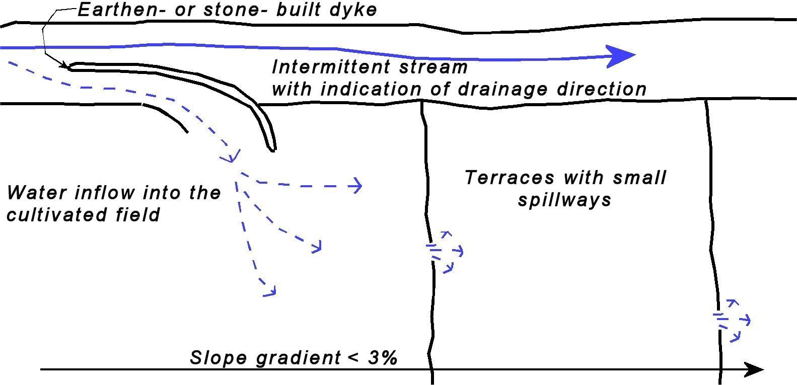
Especificaciones técnicas (relacionadas al dibujo técnico):
Sketch of a water harvesting structure consisting of an earthen- or stone- built dyke that diverts water into cultivated fields. Several terraces are present in the fields in order to reduce slope gradient and retain water longer within the fields to allow maximum infiltration. Depending on the expected inflow of water several spillways can be made per terrace to prevent excessive concentration of flow in each spillway.
Technical knowledge required for field staff / advisors: moderate (Selection of the proper location and assessment of up- and downstream linkages.)
Technical knowledge required for land users: low (Practical implementation of the water harvesting structure does not require a high level of knowledge)
Main technical functions: control of concentrated runoff: retain / trap, control of concentrated runoff: impede / retard, control of concentrated runoff: drain / divert, increase of infiltration, water harvesting / increase water supply
Secondary technical functions: increase of groundwater level / recharge of groundwater, water spreading
Spillway
Spacing between structures (m): 50
Depth of ditches/pits/dams (m): 0.5
Width of ditches/pits/dams (m): 1-3
Structural measure: water harvest dyke
Depth of ditches/pits/dams (m): <1
Width of ditches/pits/dams (m): <2
Length of ditches/pits/dams (m): <50
Construction material (earth): Soil from the stream banks is used to built the dyke and provide an opening into the cultivated fiel
Construction material (stone): Stones are used to fortify the dyke and spillways against the impact of flow.
Construction material (concrete): Potentially concrete is used to fortify the dyke and spillways against the impact of flow.
Specification of dams/ pans/ ponds: Capacity 5m3
Catchment area: >0.5km2m2
Beneficial area: 1-2 ham2
Slope of dam wall inside: 100%;
Slope of dam wall outside: 100%
Dimensions of spillways: 1-3m wide and <50 cm deep
Autor:
Joris de Vente
4.2 Información general sobre el cálculo de insumos y costos
otra / moneda nacional (especifique):
EURO
Si fuera relevante, indique la tasa de cambio de dólares americanos a la moneda local (ej. 1 U$ = 79.9 Reales Brasileros): 1 U$ =:
0,63
Indique el costo promedio del salario de trabajo contratado por día:
79.00
4.3 Actividades de establecimiento
| Actividad | Momento (estación) | |
|---|---|---|
| 1. | Construction of a dyke (dam) | summer or winter |
4.4 Costos e insumos necesarios para el establecimiento
| Especifique insumo | Unidad | Cantidad | Costos por unidad | Costos totales por insumo | % de los costos cubiertos por los usuarios de las tierras | |
|---|---|---|---|---|---|---|
| Mano de obra | Labour | 5 meter dyke | 1,0 | 150,0 | 150,0 | 100,0 |
| Equipo | Machine use | 5 meter dyke | 1,0 | 350,0 | 350,0 | 100,0 |
| Material de construcción | Concrete | 5 meter dyke | 1,0 | 400,0 | 400,0 | 100,0 |
| Costos totales para establecer la Tecnología | 900,0 | |||||
| Costos totales para establecer la Tecnología en USD | 1428,57 | |||||
Comentarios:
Duration of establishment phase: 1 month(s)
4.5 Actividades de establecimiento/ recurrentes
| Actividad | Momento/ frequencia | |
|---|---|---|
| 1. | restoration of the dyke | once in 5 yr (after important events) |
4.6 Costos e insumos necesarios para actividades de mantenimiento/ recurrentes (por año)
| Especifique insumo | Unidad | Cantidad | Costos por unidad | Costos totales por insumo | % de los costos cubiertos por los usuarios de las tierras | |
|---|---|---|---|---|---|---|
| Mano de obra | Labour | 5 meter dyke | 1,0 | 4,0 | 4,0 | 100,0 |
| Equipo | Machine use | 5 meter dyke | 1,0 | 12,0 | 12,0 | 100,0 |
| Material de construcción | Concrete | 5 meter dyke | 1,0 | 25,0 | 25,0 | 100,0 |
| Indique los costos totales para mantenecer la Tecnología | 41,0 | |||||
| Costos totales para mantener la Tecnología en USD | 65,08 | |||||
Comentarios:
Machinery/ tools: For construction and maintenance of the dyke tractor or small bulldozer is required.
The costs were indicated assuming a length of the bund dimensions of 5*1*1 metres. Maintenance is required once every 5 years, so yearly costs are the total costs divided by 5 (Prices are for spring 2008).
4.7 Factores más determinantes que afectan los costos:
Describa los factores más determinantes que afectan los costos:
Labour costs and price of concrete are the most determinate factors affecting the costs.
5. Entorno natural y humano
5.1 Clima
Lluvia anual
- < 250 mm
- 251-500 mm
- 501-750 mm
- 751-1,000 mm
- 1,001-1,500 mm
- 1,501-2,000 mm
- 2,001-3,000 mm
- 3,001-4,000 mm
- > 4,000 mm
Especifique el promedio anual de lluvia (si lo conoce), en mm:
300,00
Zona agroclimática
- semi-árida
Thermal climate class: subtropics
Thermal climate class: temperate. The higher parts are generally somewhat colder
5.2 Topografía
Pendientes en promedio:
- plana (0-2 %)
- ligera (3-5%)
- moderada (6-10%)
- ondulada (11-15%)
- accidentada (16-30%)
- empinada (31-60%)
- muy empinada (>60%)
Formaciones telúricas:
- meseta/ planicies
- cordilleras
- laderas montañosas
- laderas de cerro
- pies de monte
- fondo del valle
Zona altitudinal:
- 0-100 m s.n.m.
- 101-500 m s.n.m.
- 501-1,000 m s.n.m
- 1,001-1,500 m s.n.m
- 1,501-2,000 m s.n.m
- 2,001-2,500 m s.n.m
- 2,501-3,000 m s.n.m
- 3,001-4,000 m s.n.m
- > 4,000 m s.n.m
Indique si la Tecnología se aplica específicamente en:
- situaciones cóncavas
Comentarios y especificaciones adicionales sobre topografía :
Landforms: Valley floors (mostly concave slope section)
5.3 Suelos
Profundidad promedio del suelo:
- muy superficial (0-20 cm)
- superficial (21-50 cm)
- moderadamente profunda (51-80 cm)
- profunda (81-120 cm)
- muy profunda (>120 cm)
Textura del suelo (capa arable):
- mediana (limosa)
- fina/ pesada (arcilla)
Materia orgánica de capa arable:
- media (1-3%)
- baja (<1%)
5.4 Disponibilidad y calidad de agua
Agua subterránea:
5-50 m
Disponibilidad de aguas superficiales:
pobre/ ninguna
Calidad de agua (sin tratar):
solo para uso agrícola (irrigación)
Comentarios y especificaciones adicionales sobre calidad y cantidad de agua:
Ground water table: >50m (There is a lowering of groundwater table due to overexploitation for irrigation purposes)
Availability of surface water: Poor/none. Sporadically excess when there are flash floods during extreme rainfall events
Water quality (untreated) For agricultural use only (irrigation)(groundwater)
5.5 Biodiversidad
Diversidad de especies:
- baja
5.6 Las características de los usuarios de la tierra que aplican la Tecnología
Orientación del mercado del sistema de producción:
- mixta (subsistencia/ comercial)
- comercial/ mercado
Ingresos no agrarios:
- > 50% de todo el ingreso
Nivel relativo de riqueza:
- promedio
Individuos o grupos:
- individual/ doméstico
Nivel de mecanización:
- mecanizado/motorizado
Género:
- hombres
Indique otras características relevantes de los usuarios de las tierras:
Land users applying the Technology are mainly common / average land users
Difference in the involvement of women and men: Traditionally most agriculture is done by men in this region.
Population density: 10-50 persons/km2
Annual population growth: < 0.5%
15% of the land users are rich and own 20% of the land.
80% of the land users are average wealthy and own 75% of the land.
5% of the land users are poor and own 5% of the land.
Off-farm income specification: There is no difference in the ones who apply the technology and those who don’t. Most farmers do have an off-farm income for example from hunting, work in a factory, or office.
Market orientation: Commercial/market or mixed (subsistence and commercial)(some farmers are weekend or hobby farmers and not market oriented)
5.7 Área promedio de la tierra usada por usuarios de tierra que aplican la Tecnología
- < 0.5 ha
- 0.5-1 ha
- 1-2 ha
- 2-5 ha
- 5-15 ha
- 15-50 ha
- 50-100 ha
- 100-500 ha
- 500-1,000 ha
- 1,000-10,000 ha
- > 10,000 ha
¿Esto se considera de pequeña, mediana o gran escala (refiriéndose al contexto local)?
- pequeña escala
Comentarios:
Average area of land owned or leased by land users applying the Technology: 2-5 ha, 5-15 ha, 15-50 ha, 100-500 ha (There are few farmers with large properties within the study area)(
5.8 Tenencia de tierra, uso de tierra y derechos de uso de agua
Tenencia de tierra:
- estado
- individual, con título
Derechos de uso de tierra:
- comunitarios (organizado)
- individual
Derechos de uso de agua:
- comunitarios (organizado)
- individual
Comentarios:
Most land is privately owned. The streams are not privately owned. Therefore permits are required to construct a water harvesting structure. Some shrubland or forest is state property. Water rights are provided and controlled by the Water authority of the Segura river basin (CHS).
5.9 Acceso a servicios e infraestructura
salud:
- pobre
- moderado
- bueno
educación:
- pobre
- moderado
- bueno
asistencia técnica:
- pobre
- moderado
- bueno
empleo (ej. fuera de la granja):
- pobre
- moderado
- bueno
mercados:
- pobre
- moderado
- bueno
energía:
- pobre
- moderado
- bueno
caminos y transporte:
- pobre
- moderado
- bueno
agua potable y saneamiento:
- pobre
- moderado
- bueno
servicios financieros:
- pobre
- moderado
- bueno
6. Impactos y comentarios para concluir
6.1 Impactos in situ demostrados por la Tecnología
Impactos socioeconómicos
Producción
producción de cultivo
Comentarios/ especifique:
Depending on the amount of water harvested yield may be the same or increase slightly
riesgo de fracaso de producción
Disponibilidad y calidad de agua
disponibilidad de agua para irrigar
calidad de agua para irrigar
Ingreso y costos
gastos en insumos agrícolas
Comentarios/ especifique:
Implementation of dykes is considered relatively expensive
ingreso agrario
Impactos socioculturales
mitigación de conflicto
Comentarios/ especifique:
Water extraction by a water harvesting may cause less water at downstream locations, whihc may cause conflicts
Improved livelihoods and human well-being
Comentarios/ especifique:
during Roman and Arab times when most structures were operative they increased significantly the production. Nowadays, most of them are abandoned. However, those that are operational do cause increased crop yields.
Impactos ecológicos
Ciclo de agua/ escurrimiento de sedimento
cantidad de agua
cosecha/ recolección de agua
escurrimiento superficial
drenaje de agua en exceso
Comentarios/ especifique:
For small flood events only
nivel freático/ acuífero
Comentarios/ especifique:
Possibly a small effect
Suelo
humedad del suelo
6.2 Impactos fuera del sitio demostrados por la Tecnología
corriente confiable y estable fluye en estación seca
inundaciones río abajo
Comentarios/ especifique:
If various structures are present in a stream and only for relatively low intensity events
daños a infraestructura pública / privada
6.3 Exposición y sensibilidad de la Tecnología al cambio climático gradual y a extremos relacionados al clima/ desastres (desde la percepción de los usuarios de tierras)
Cambio climático gradual
Cambio climático gradual
| Estación | Incremento o reducción | ¿Cómo es que la tecnología soporta esto? | |
|---|---|---|---|
| temperatura anual | incrementó | bien |
Extremos (desastres) relacionados al clima
Desastres climatológicos:
| ¿Cómo es que la tecnología soporta esto? | |
|---|---|
| tormenta de lluvia local | no muy bien |
| tormenta de viento | bien |
Desastres climatológicos
| ¿Cómo es que la tecnología soporta esto? | |
|---|---|
| sequía | bien |
Desastres hidrológicos
| ¿Cómo es que la tecnología soporta esto? | |
|---|---|
| inundación general (río) | no muy bien |
Otras consecuencias relacionadas al clima
Otras consecuencias relacionadas al clima
| ¿Cómo es que la tecnología soporta esto? | |
|---|---|
| periodo reducido de crecimiento | bien |
Comentarios:
The crop type is sensitive to changes in water availability under the semi arid conditions.
6.4 Análisis costo-beneficio
¿Cómo se comparan los beneficios con los costos de establecimiento (desde la perspectiva de los usuarios de tierra)?
Ingresos a corto plazo:
negativo
Ingresos a largo plazo:
positivo
¿Cómo se comparan los beneficios con los costos de mantenimiento/ recurrentes (desde la perspectiva de los usuarios de tierra)?
Ingresos a corto plazo:
positivo
Ingresos a largo plazo:
positivo
Comentarios:
Implementation of the technology is relatively expensive. Once installed, maintenance is not expensive and pays off because of higher productivity.
6.5 Adopción de la Tecnología
De todos quienes adoptaron la Tecnología, ¿cuántos lo hicieron espontáneamente, por ej. sin recibir nada de incentivos/ materiales:
- 91-100%
Comentarios:
100% of land user families have adopted the Technology without any external material support
There is no trend towards spontaneous adoption of the Technology
Comments on adoption trend: Much of this knowledge is forgotten and not applied or maintained anymore.
6.7 Fuerzas/ ventajas/ oportunidades de la Tecnología
| Fuerzas/ ventajas/ oportunidades desde la perspectiva del usuario de la tierra |
|---|
| The extra input of free water allows higher crop productivity. |
| Fuerzas/ ventajas/ oportunidades desde la perspectiva del compilador o de otra persona de referencia clave |
|---|
|
This technology is very effective at increasing water available for crop production and so increasing crop yield and farm income How can they be sustained / enhanced? Temporarily store the harvested water in a cistern to be used for irrigation using drip irrigation when most needed. |
|
The technology takes advantage of floodwater that is otherwise lost because of the erratic character and short duration of flow How can they be sustained / enhanced? Finding the optimal location for the water harvesting structures using a modelling approach |
6.8 Debilidades/ desventajas/ riesgos de la Tecnología y formas de sobreponerse a ellos
| Debilidades/ desventajas/ riesgos desde la perspectiva del usuario de la tierra | ¿Cómo sobreponerse a ellas? |
|---|---|
| Farmers consider it relatively expensive to implement and there is no guarantee for water as this depends on the rainfall events. | Subsidies might help to install these structures where feasible. Therefore, good assessments of expected water inflow volumes are required before construction |
| Debilidades/ desventajas/ riesgos desde la perspectiva del compilador o de otra persona de referencia clave | ¿Cómo sobreponerse a ellas? |
|---|---|
| The implementation costs are relatively high when the bunds are made of concrete | Use of cheap materials that are freely available (stones from the fields). However, it is important to make the structure as resistant as possible against flood events. |
| The water provided by these techniques is mostly interesting for small- and medium- scale rainfed farming. Intensively irrigated farming requires more water and a guarantee for water independently of flood events | Intensively irrigated farming might use this technology as an additional source of water and may store the harvested water in a cistern for use when needed. |
7. Referencias y vínculos
7.1 Métodos/ fuentes de información
7.2 Vínculos a las publicaciones disponibles
Título, autor, año, ISBN:
rot, E., van Wesemael, B., Benet, A.S. and House, M.A., 2008. Water harvesting potential in function of hillslope characteristics: A case study from the Sierra de Gador Journal of Arid Environments 72(7):1213-1231
¿Dónde se halla disponible? ¿Costo?
Internet
Título, autor, año, ISBN:
Giráldez, J.V., Ayuso, J.L., Garcia, A., López, J.G. and Roldán, J., 1988. Water harvesting strategies in the semiarid climate of southeastern Spain. Agricultural Water Management, 14(1-4): 253-263.
¿Dónde se halla disponible? ¿Costo?
Internet
Título, autor, año, ISBN:
Hooke, J.M. and Mant, J.M., 2002. Floodwater use and management strategies in valleys of southeast Spain. Land Degradation & Development, 13(2): 165-175.
¿Dónde se halla disponible? ¿Costo?
Internet
Título, autor, año, ISBN:
López-Gálvez, J. and Losada, A., 1998. EVOLUCIÓN DE TÉCNICAS DE RIEGO EN EL SUDESTE DE ESPAÑA. Ingeniería del Agua, 5(3): 41-50.
¿Dónde se halla disponible? ¿Costo?
Internet
Título, autor, año, ISBN:
Nasri, S., Albergel, J., Cudennec, C. and Berndtsson, R., 2004. Hydrological processes in macrocatchment water harvestingin the arid region of Tunisia: the traditional system of tabias. Hydrological Sciences-Journal, 49(2): 261-272.
¿Dónde se halla disponible? ¿Costo?
Internet
Título, autor, año, ISBN:
van Wesemael, B., et al., 1998. Collection and storage of runoff from hillslopes in a semi-arid environment: geomorphic and hydrologic aspects of the aljibe system in Almeria (Spain). Journal of Arid Environments 40(1):1-14
¿Dónde se halla disponible? ¿Costo?
Internet
Título, autor, año, ISBN:
Greenpeace, 2007. El negocio del agua en la cuenca del Segura, Greenpeace.
¿Dónde se halla disponible? ¿Costo?
www.greenpeace.es
Vínculos y módulos
Expandir todo Colapsar todosVínculos
No hay vínculos
Módulos
No se hallaron módulos