Water harvesting from concentrated runoff for irrigation purposes [Espanha]
- Criação:
- Atualização:
- Compilador/a: Joris De Vente
- Editor: –
- Revisores: Deborah Niggli, Alexandra Gavilano
Boqueras (Spanish)
technologies_1517 - Espanha
- Resumo completo em PDF
- Resumo completo em PDF para impressão
- Resumo completo no navegador
- Resumo completo (sem formatação)
- Water harvesting from concentrated runoff for irrigation purposes: 23 de Julho de 2019 (public)
- Water harvesting from concentrated runoff for irrigation purposes: 4 de Abril de 2018 (inactive)
- Water harvesting from concentrated runoff for irrigation purposes: 4 de Abril de 2018 (inactive)
- Water harvesting from concentrated runoff for irrigation purposes: 5 de Agosto de 2017 (inactive)
- Water harvesting from concentrated runoff for irrigation purposes: 14 de Março de 2017 (inactive)
Veja as seções
Expandir tudo Recolher tudo1. Informação geral
1.2 Detalhes do contato das pessoas capacitadas e instituições envolvidas na avaliação e documentação da tecnologia
Especialista em GST:
Especialista em GST:
López Carratala Jorge
Consejo Superior de Investigaciones Científicas, Estación Experimental de Zonas Áridas (EEZA-CSIC)
Espanha
Especialista em GST:
Ibáñez Torres Ascensión
Consejería de Agricultura y Agua Murcia (CARM)
Espanha
usuário de terra:
Escamez Antonio
Espanha
Especialista em GST:
Researcher Université Catholique de Lovain (UCL)
Bélgica
Nome do projeto que facilitou a documentação/avaliação da Tecnologia (se relevante)
DESIRE (EU-DES!RE)Nome do projeto que facilitou a documentação/avaliação da Tecnologia (se relevante)
Book project: Water Harvesting – Guidelines to Good Practice (Water Harvesting)Nome da(s) instituição(ões) que facilitou(ram) a documentação/ avaliação da Tecnologia (se relevante)
EEZA-CSIC (EEZA-CSIC) - EspanhaNome da(s) instituição(ões) que facilitou(ram) a documentação/ avaliação da Tecnologia (se relevante)
Consejería de Agricultura y Agua Murcia (CARM) - Espanha1.3 Condições em relação ao uso da informação documentada através de WOCAT
O compilador e a(s) pessoa(s) capacitada(s) aceitam as condições relativas ao uso de dados documentados através do WOCAT:
Sim
2. Descrição da tecnologia de GST
2.1 Descrição curta da tecnologia
Definição da tecnologia:
Water harvesting from intermittent streams towards nearby fields and terraces during runoff events.
2.2 Descrição detalhada da tecnologia
Descrição:
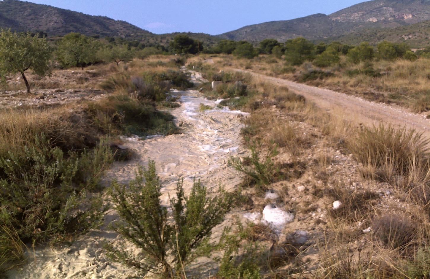
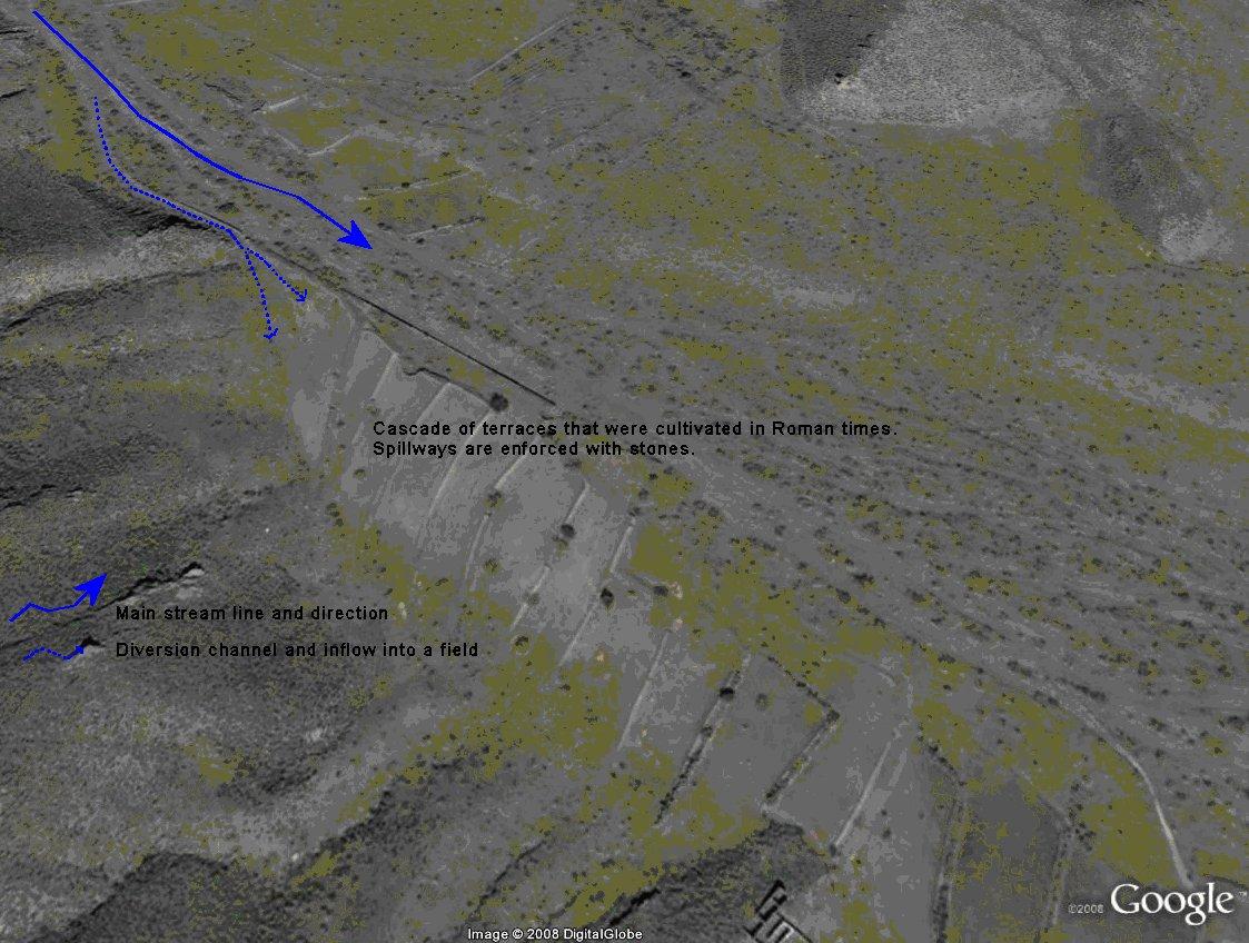
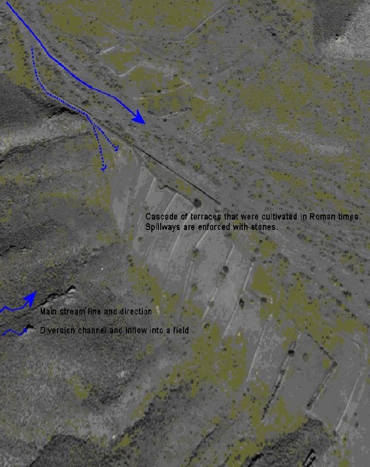
Water shortage is one of the most limiting factors for sustainable agriculture in large parts of SE-Spain. Part of the solution of this problem may come from the restoration of traditional water harvesting structures. Many of these structures were widely used in SE-Spain already during Arab and Roman times, and are also widespread in N-Africa and the Middle East. However, nowadays in Spain many of them are abandoned and forgotten. Here, we describe the technology of a small earthen- or stone- built bund that diverts flood water from intermittent streams towards cultivated fields with almond orchards and/or cereals. The diverted water will temporarily flood the fields and provide the crops with water. Depending on the slope gradient and the amount of water to be harvested, the fields are organised as single terraces, or as a staircase of terraces. On fields with gradients above ~3%, terraces are necessary to reduce the gradient and to retain the floodwater as long as possible. Water is diverted from one terrace to the next through small spillways in the terrace. The spillways can best be fortified with stones to prevent bank gully formation. The extra input of surface water can double the almond yield. The use of these water harvesting structures is only possible under certain environmental and topographic conditions. The cultivated fields should be at a relatively short distance from an intermittent stream (<~50m), and the stream should have a sufficiently large upstream contributing area to provide significant amounts of runoff water during rainfall events. With these systems, water can be harvested up to 8 times per year, mostly in spring and autumn during high intensity rainfall events. A well designed Boquera system may provide up to 550 mm of additional water, in areas with an average annual rainfall of 300 m.
Purpose of the Technology: The goal of this technology is to increase crop yield. In addition, these structures help to reduce the intensity of floods and reduce the damage caused by them by reducing runoff volume in intermittent streams.
Establishment / maintenance activities and inputs: Water harvesting requires the identification of a suitable location for the construction of a diversion structure. This requires assessment of expected water inflow, which can usually be based on simple field observation during rainfall events and based on local knowledge of land users. It is, however, important to consider whether there are activities upstream that possibly affect the water quality (e.g. farm animals) and to assess the implications the water harvesting might have downstream. Permission is required from the water authorities to construct any type of water harvesting structure. Such structures are built by creating a small bund (<1m height) in the centre or to the side of a stream. Depending on the size, the bund can be built with a shovel or a tractor. The water harvesting structure will require control and some maintenance after each important runoff event. When strengthened with concrete, maintenance will be reduced to approximately once every 5 years.
Natural / human environment: Soils are mostly of shallow to medium depth (20-60 cm), and slopes are gentle to moderate (5-15%). The climate is semi-arid with a mean annual rainfall around 300 mm. Droughts, centred in summer commonly last for more than 4-5 months. Annual potential evapotranspiration rates larger than 1000 mm are common.
2.3 Fotos da tecnologia
Galeria de Mídias
2.5 País/região/locais onde a tecnologia foi aplicada e que estão cobertos nesta avaliação
País:
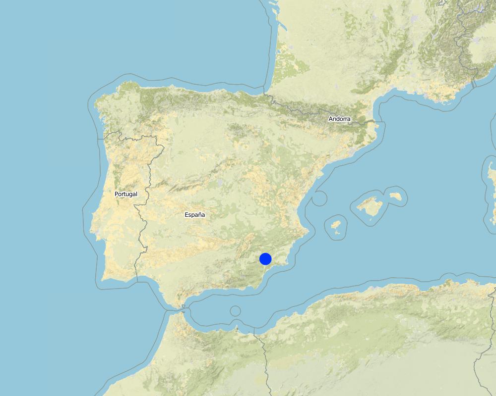
Espanha
Região/Estado/Província:
Murcia
Especificação adicional de localização:
Guadalentin catchment
Especifique a difusão da tecnologia:
- Uniformemente difundida numa área
Se a área precisa não for conhecida, indicar a área aproximada coberta:
- < 0,1 km2 (10 ha)
Map
×2.6 Data da implementação
Caso o ano exato seja desconhecido, indique a data aproximada:
- mais de 50 anos atrás (tradicional)
2.7 Introdução da tecnologia
Especifique como a tecnologia foi introduzida:
- Como parte do sistema tradicional (>50 anos)
Comentários (tipos de projeto, etc.):
Most of the water harvesting structures are already much older than 50 years and originate even from Roman or Arab times.
3. Classificação da tecnologia de GST
3.2 Tipo(s) atualizado(s) de uso da terra onde a tecnologia foi aplicada
Uso do solo misturado dentro da mesma unidade de terra:
Sim
Especificar o uso misto da terra (culturas/ pastoreio/ árvores):
- Agrofloresta

Terra de cultivo
- Cultura anual
- Cultura de árvores e arbustos
Cultivo anual - Especificar culturas:
- cereais - aveia
- almonds
Número de estações de cultivo por ano:
- 1
Especifique:
Longest growing period in days: 220Longest growing period from month to month: november until June
Comentários:
Major land use problems (compiler’s opinion): There is a lack of water for irrigation of crops limiting the crop types that can be planted as well as the crop yield of dryland farming. A lack of water availability seriously limits the production potential of the soil and results in a low vegetation/crop cover. The relatively high soil erosion rates cause various off-site related problems (i.e. flooding, reservoir siltation) and on-site problems (i.e. gully formation and loss of soil depth).
Major land use problems (land users’ perception): Lack of water for irrigation of crops limiting the crop types that can be planted as well as the crop yield of dryland farming.
Livestock is grazing on crop residues
3.5 Grupo de GST ao qual pertence a tecnologia
- Coleta de água
3.6 Medidas de GST contendo a tecnologia

Medidas estruturais
- S1: Terraços
- S4: Valas de nível, fossos
- S11: Outros
Comentários:
Main measures: structural measures
3.7 Principais tipos de degradação da terra abordados pela tecnologia

Erosão do solo pela água
- Wo: efeitos de degradação externa

Degradação da água
- Ha: aridificação
Comentários:
Main type of degradation addressed: Ha: aridification
Secondary types of degradation addressed: Wo: offsite degradation effects
Main causes of degradation: droughts (Dry periods and dry years require higher water availability)
Secondary causes of degradation: crop management (annual, perennial, tree/shrub) (Large areas without a protective vegetation cover cause increased runoff and erosion rates and facilitat flash floods), over abstraction / excessive withdrawal of water (for irrigation, industry, etc.) (Over-abstraction leads to a lowering of the water table. Therefore additional aquifer abstraction is not allowed by water authority.), Heavy / extreme rainfall (intensity/amounts) (Extreme rainfall causes flash floods with high water losses and low effectiveness for crop production.)
3.8 Redução, prevenção ou recuperação da degradação do solo
Especifique o objetivo da tecnologia em relação a degradação da terra:
- Prevenir degradação do solo
- Reduzir a degradação do solo
Comentários:
Main goals: prevention of land degradation, mitigation / reduction of land degradation
4. Especificações técnicas, implementação de atividades, entradas e custos
4.1 Desenho técnico da tecnologia
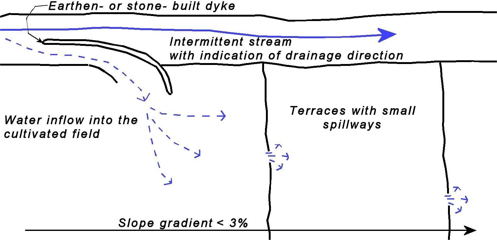
Especificações técnicas (relacionada ao desenho técnico):
Sketch of a water harvesting structure consisting of an earthen- or stone- built dyke that diverts water into cultivated fields. Several terraces are present in the fields in order to reduce slope gradient and retain water longer within the fields to allow maximum infiltration. Depending on the expected inflow of water several spillways can be made per terrace to prevent excessive concentration of flow in each spillway.
Technical knowledge required for field staff / advisors: moderate (Selection of the proper location and assessment of up- and downstream linkages.)
Technical knowledge required for land users: low (Practical implementation of the water harvesting structure does not require a high level of knowledge)
Main technical functions: control of concentrated runoff: retain / trap, control of concentrated runoff: impede / retard, control of concentrated runoff: drain / divert, increase of infiltration, water harvesting / increase water supply
Secondary technical functions: increase of groundwater level / recharge of groundwater, water spreading
Spillway
Spacing between structures (m): 50
Depth of ditches/pits/dams (m): 0.5
Width of ditches/pits/dams (m): 1-3
Structural measure: water harvest dyke
Depth of ditches/pits/dams (m): <1
Width of ditches/pits/dams (m): <2
Length of ditches/pits/dams (m): <50
Construction material (earth): Soil from the stream banks is used to built the dyke and provide an opening into the cultivated fiel
Construction material (stone): Stones are used to fortify the dyke and spillways against the impact of flow.
Construction material (concrete): Potentially concrete is used to fortify the dyke and spillways against the impact of flow.
Specification of dams/ pans/ ponds: Capacity 5m3
Catchment area: >0.5km2m2
Beneficial area: 1-2 ham2
Slope of dam wall inside: 100%;
Slope of dam wall outside: 100%
Dimensions of spillways: 1-3m wide and <50 cm deep
Autor:
Joris de Vente
4.2 Informação geral em relação ao cálculo de entradas e custos
Outro/moeda nacional (especifique):
EURO
Se for relevante, indique a taxa de câmbio do USD para moeda local (por exemplo, 1 USD = 79,9 Real): 1 USD =:
0,63
Indique a média salarial da mão-de-obra contratada por dia:
79.00
4.3 Atividades de implantação
| Atividade | Periodicidade (estação do ano) | |
|---|---|---|
| 1. | Construction of a dyke (dam) | summer or winter |
4.4 Custos e entradas necessárias para a implantação
| Especifique a entrada | Unidade | Quantidade | Custos por unidade | Custos totais por entrada | % dos custos arcados pelos usuários da terra | |
|---|---|---|---|---|---|---|
| Mão-de-obra | Labour | 5 meter dyke | 1,0 | 150,0 | 150,0 | 100,0 |
| Equipamento | Machine use | 5 meter dyke | 1,0 | 350,0 | 350,0 | 100,0 |
| Material de construção | Concrete | 5 meter dyke | 1,0 | 400,0 | 400,0 | 100,0 |
| Custos totais para a implantação da tecnologia | 900,0 | |||||
| Custos totais para o estabelecimento da Tecnologia em USD | 1428,57 | |||||
Comentários:
Duration of establishment phase: 1 month(s)
4.5 Atividades recorrentes/manutenção
| Atividade | Periodicidade/frequência | |
|---|---|---|
| 1. | restoration of the dyke | once in 5 yr (after important events) |
4.6 Custos e entradas necessárias pata a manutenção/atividades recorrentes (por ano)
| Especifique a entrada | Unidade | Quantidade | Custos por unidade | Custos totais por entrada | % dos custos arcados pelos usuários da terra | |
|---|---|---|---|---|---|---|
| Mão-de-obra | Labour | 5 meter dyke | 1,0 | 4,0 | 4,0 | 100,0 |
| Equipamento | Machine use | 5 meter dyke | 1,0 | 12,0 | 12,0 | 100,0 |
| Material de construção | Concrete | 5 meter dyke | 1,0 | 25,0 | 25,0 | 100,0 |
| Custos totais para a manutenção da tecnologia | 41,0 | |||||
| Custos totais de manutenção da Tecnologia em USD | 65,08 | |||||
Comentários:
Machinery/ tools: For construction and maintenance of the dyke tractor or small bulldozer is required.
The costs were indicated assuming a length of the bund dimensions of 5*1*1 metres. Maintenance is required once every 5 years, so yearly costs are the total costs divided by 5 (Prices are for spring 2008).
4.7 Fatores mais importantes que afetam os custos
Descreva os fatores mais determinantes que afetam os custos:
Labour costs and price of concrete are the most determinate factors affecting the costs.
5. Ambiente natural e humano
5.1 Clima
Precipitação pluviométrica anual
- <250 mm
- 251-500 mm
- 501-750 mm
- 751-1.000 mm
- 1.001-1.500 mm
- 1.501-2.000 mm
- 2.001-3.000 mm
- 3.001-4.000 mm
- > 4.000 mm
Especifique a média pluviométrica anual em mm (se conhecida):
300,00
Zona agroclimática
- Semiárido
Thermal climate class: subtropics
Thermal climate class: temperate. The higher parts are generally somewhat colder
5.2 Topografia
Declividade média:
- Plano (0-2%)
- Suave ondulado (3-5%)
- Ondulado (6-10%)
- Moderadamente ondulado (11-15%)
- Forte ondulado (16-30%)
- Montanhoso (31-60%)
- Escarpado (>60%)
Formas de relevo:
- Planalto/planície
- Cumes
- Encosta de serra
- Encosta de morro
- Sopés
- Fundos de vale
Zona de altitude:
- 0-100 m s.n.m.
- 101-500 m s.n.m.
- 501-1.000 m s.n.m.
- 1.001-1.500 m s.n.m.
- 1.501-2.000 m s.n.m.
- 2.001-2.500 m s.n.m.
- 2.501-3.000 m s.n.m.
- 3.001-4.000 m s.n.m.
- > 4.000 m s.n.m.
Indique se a tecnologia é aplicada especificamente em:
- Posições côncavas
Comentários e outras especificações sobre a topografia:
Landforms: Valley floors (mostly concave slope section)
5.3 Solos
Profundidade do solo em média:
- Muito raso (0-20 cm)
- Raso (21-50 cm)
- Moderadamente profundo (51-80 cm)
- Profundo (81-120 cm)
- Muito profundo (>120 cm)
Textura do solo (solo superficial):
- Médio (limoso, siltoso)
- Fino/pesado (argila)
Matéria orgânica do solo superficial:
- Médio (1-3%)
- Baixo (<1%)
5.4 Disponibilidade e qualidade de água
Lençol freático:
5-50 m
Disponibilidade de água de superfície:
Precário/nenhum
Qualidade da água (não tratada):
apenas para uso agrícola (irrigação)
Comentários e outras especificações sobre a qualidade e a quantidade da água:
Ground water table: >50m (There is a lowering of groundwater table due to overexploitation for irrigation purposes)
Availability of surface water: Poor/none. Sporadically excess when there are flash floods during extreme rainfall events
Water quality (untreated) For agricultural use only (irrigation)(groundwater)
5.5 Biodiversidade
Diversidade de espécies:
- Baixo
5.6 Características dos usuários da terra que utilizam a tecnologia
Orientação de mercado do sistema de produção:
- misto (subsistência/comercial)
- Comercial/mercado
Rendimento não agrícola:
- >50% de toda renda
Nível relativo de riqueza:
- Média
Indivíduos ou grupos:
- Indivíduo/unidade familiar
Nível de mecanização:
- Mecanizado/motorizado
Gênero:
- Homens
Indique outras características relevantes dos usuários da terra:
Land users applying the Technology are mainly common / average land users
Difference in the involvement of women and men: Traditionally most agriculture is done by men in this region.
Population density: 10-50 persons/km2
Annual population growth: < 0.5%
15% of the land users are rich and own 20% of the land.
80% of the land users are average wealthy and own 75% of the land.
5% of the land users are poor and own 5% of the land.
Off-farm income specification: There is no difference in the ones who apply the technology and those who don’t. Most farmers do have an off-farm income for example from hunting, work in a factory, or office.
Market orientation: Commercial/market or mixed (subsistence and commercial)(some farmers are weekend or hobby farmers and not market oriented)
5.7 Área média de terrenos utilizados pelos usuários de terrenos que aplicam a Tecnologia
- < 0,5 ha
- 0,5-1 ha
- 1-2 ha
- 2-5 ha
- 5-15 ha
- 15-50 ha
- 50-100 ha
- 100-500 ha
- 500-1.000 ha
- 1.000-10.000 ha
- > 10.000 ha
É considerado pequena, média ou grande escala (referente ao contexto local)?
- Pequena escala
Comentários:
Average area of land owned or leased by land users applying the Technology: 2-5 ha, 5-15 ha, 15-50 ha, 100-500 ha (There are few farmers with large properties within the study area)(
5.8 Propriedade de terra, direitos de uso da terra e de uso da água
Propriedade da terra:
- Estado
- Indivíduo, intitulado
Direitos do uso da terra:
- Comunitário (organizado)
- Indivíduo
Direitos do uso da água:
- Comunitário (organizado)
- Indivíduo
Comentários:
Most land is privately owned. The streams are not privately owned. Therefore permits are required to construct a water harvesting structure. Some shrubland or forest is state property. Water rights are provided and controlled by the Water authority of the Segura river basin (CHS).
5.9 Acesso a serviços e infraestrutura
Saúde:
- Pobre
- Moderado
- Bom
Educação:
- Pobre
- Moderado
- Bom
Assistência técnica:
- Pobre
- Moderado
- Bom
Emprego (p. ex. não agrícola):
- Pobre
- Moderado
- Bom
Mercados:
- Pobre
- Moderado
- Bom
Energia:
- Pobre
- Moderado
- Bom
Vias e transporte:
- Pobre
- Moderado
- Bom
Água potável e saneamento:
- Pobre
- Moderado
- Bom
Serviços financeiros:
- Pobre
- Moderado
- Bom
6. Impactos e declarações finais
6.1 Impactos no local mostrados pela tecnologia
Impactos socioeconômicos
Produção
Produção agrícola
Comentários/especificar:
Depending on the amount of water harvested yield may be the same or increase slightly
Risco de falha de produção
Disponibilidade e qualidade de água
Disponibilidade de água para irrigação
Qualidade da água para irrigação
Renda e custos
Despesas com insumos agrícolas
Comentários/especificar:
Implementation of dykes is considered relatively expensive
Rendimento agrícola
Impactos socioculturais
Atenuação de conflitos
Comentários/especificar:
Water extraction by a water harvesting may cause less water at downstream locations, whihc may cause conflicts
Improved livelihoods and human well-being
Comentários/especificar:
during Roman and Arab times when most structures were operative they increased significantly the production. Nowadays, most of them are abandoned. However, those that are operational do cause increased crop yields.
Impactos ecológicos
Ciclo hídrico/escoamento
Quantidade de água
Colheita/recolhimento de água
Escoamento superficial
Drenagem de excesso de água
Comentários/especificar:
For small flood events only
Lençol freático/aquífero
Comentários/especificar:
Possibly a small effect
Solo
Umidade do solo
6.2 Impactos externos mostrados pela tecnologia
Caudal confiável e estável em período seco
Cheias de jusante
Comentários/especificar:
If various structures are present in a stream and only for relatively low intensity events
Danos na infraestrutura pública/privada
6.3 Exposição e sensibilidade da tecnologia às mudanças climáticas graduais e extremos/desastres relacionados ao clima (conforme o ponto de vista dos usuários da terra)
Mudança climática gradual
Mudança climática gradual
| Estação do ano | aumento ou diminuição | Como a tecnologia lida com isso? | |
|---|---|---|---|
| Temperatura anual | aumento | bem |
Extremos (desastres) relacionados ao clima
Desastres meteorológicos
| Como a tecnologia lida com isso? | |
|---|---|
| Temporal local | não bem |
| Tempestade de vento local | bem |
Desastres climatológicos
| Como a tecnologia lida com isso? | |
|---|---|
| Seca | bem |
Desastres hidrológicos
| Como a tecnologia lida com isso? | |
|---|---|
| Inundação geral (rio) | não bem |
Outras consequências relacionadas ao clima
Outras consequências relacionadas ao clima
| Como a tecnologia lida com isso? | |
|---|---|
| Período de crescimento reduzido | bem |
Comentários:
The crop type is sensitive to changes in water availability under the semi arid conditions.
6.4 Análise do custo-benefício
Como os benefícios se comparam aos custos de implantação (do ponto de vista dos usuários da terra)?
Retornos a curto prazo:
negativo
Retornos a longo prazo:
positivo
Como os benefícios se comparam aos custos recorrentes/de manutenção(do ponto de vista dos usuários da terra)?
Retornos a curto prazo:
positivo
Retornos a longo prazo:
positivo
Comentários:
Implementation of the technology is relatively expensive. Once installed, maintenance is not expensive and pays off because of higher productivity.
6.5 Adoção da tecnologia
De todos aqueles que adotaram a Tecnologia, quantos o fizeram espontaneamente, ou seja, sem receber nenhum incentivo/ pagamento material?
- 91-100%
Comentários:
100% of land user families have adopted the Technology without any external material support
There is no trend towards spontaneous adoption of the Technology
Comments on adoption trend: Much of this knowledge is forgotten and not applied or maintained anymore.
6.7 Pontos fortes/vantagens/oportunidades da tecnologia
| Pontos fortes/vantagens/oportunidades na visão do usuário da terra |
|---|
| The extra input of free water allows higher crop productivity. |
| Pontos fortes/vantagens/oportunidades na visão do compilador ou de outra pessoa capacitada |
|---|
|
This technology is very effective at increasing water available for crop production and so increasing crop yield and farm income How can they be sustained / enhanced? Temporarily store the harvested water in a cistern to be used for irrigation using drip irrigation when most needed. |
|
The technology takes advantage of floodwater that is otherwise lost because of the erratic character and short duration of flow How can they be sustained / enhanced? Finding the optimal location for the water harvesting structures using a modelling approach |
6.8 Pontos fracos, desvantagens/riscos da tecnologia e formas de superá-los
| Pontos fracos/desvantagens/riscos na visão do usuário da terra | Como eles podem ser superados? |
|---|---|
| Farmers consider it relatively expensive to implement and there is no guarantee for water as this depends on the rainfall events. | Subsidies might help to install these structures where feasible. Therefore, good assessments of expected water inflow volumes are required before construction |
| Pontos fracos/vantagens/riscos na visão do compilador ou de outra pessoa capacitada | Como eles podem ser superados? |
|---|---|
| The implementation costs are relatively high when the bunds are made of concrete | Use of cheap materials that are freely available (stones from the fields). However, it is important to make the structure as resistant as possible against flood events. |
| The water provided by these techniques is mostly interesting for small- and medium- scale rainfed farming. Intensively irrigated farming requires more water and a guarantee for water independently of flood events | Intensively irrigated farming might use this technology as an additional source of water and may store the harvested water in a cistern for use when needed. |
7. Referências e links
7.1 Métodos/fontes de informação
7.2 Referências às publicações disponíveis
Título, autor, ano, ISBN:
rot, E., van Wesemael, B., Benet, A.S. and House, M.A., 2008. Water harvesting potential in function of hillslope characteristics: A case study from the Sierra de Gador Journal of Arid Environments 72(7):1213-1231
Disponível de onde? Custos?
Internet
Título, autor, ano, ISBN:
Giráldez, J.V., Ayuso, J.L., Garcia, A., López, J.G. and Roldán, J., 1988. Water harvesting strategies in the semiarid climate of southeastern Spain. Agricultural Water Management, 14(1-4): 253-263.
Disponível de onde? Custos?
Internet
Título, autor, ano, ISBN:
Hooke, J.M. and Mant, J.M., 2002. Floodwater use and management strategies in valleys of southeast Spain. Land Degradation & Development, 13(2): 165-175.
Disponível de onde? Custos?
Internet
Título, autor, ano, ISBN:
López-Gálvez, J. and Losada, A., 1998. EVOLUCIÓN DE TÉCNICAS DE RIEGO EN EL SUDESTE DE ESPAÑA. Ingeniería del Agua, 5(3): 41-50.
Disponível de onde? Custos?
Internet
Título, autor, ano, ISBN:
Nasri, S., Albergel, J., Cudennec, C. and Berndtsson, R., 2004. Hydrological processes in macrocatchment water harvestingin the arid region of Tunisia: the traditional system of tabias. Hydrological Sciences-Journal, 49(2): 261-272.
Disponível de onde? Custos?
Internet
Título, autor, ano, ISBN:
van Wesemael, B., et al., 1998. Collection and storage of runoff from hillslopes in a semi-arid environment: geomorphic and hydrologic aspects of the aljibe system in Almeria (Spain). Journal of Arid Environments 40(1):1-14
Disponível de onde? Custos?
Internet
Título, autor, ano, ISBN:
Greenpeace, 2007. El negocio del agua en la cuenca del Segura, Greenpeace.
Disponível de onde? Custos?
www.greenpeace.es
Links e módulos
Expandir tudo Recolher tudoLinks
Não há links
Módulos
Não há módulos