Mechanized micro water harvesting through ‘Vallerani’ tractor plough for central Jordanian Badia [Jordania]
- Creación:
- Actualización:
- Compilador: Mira Haddad
- Editor: –
- Revisores: William Critchley, Rima Mekdaschi Studer
Vallerani (تقنية حصاد المياه بالمساقط الصغيرة (الفاليراني)
technologies_5860 - Jordania
Visualizar secciones
Expandir todo Colapsar todos1. Información general
1.2 Detalles de contacto de las personas de referencia e instituciones involucradas en la evaluación y la documentación de la Tecnología
Persona(s) de referencia clave
Third Year Bachelor Student: International Land and Water Management:
Especialista MST:
Strohmeier Stefan
International Center of Agriculture Research in the Dry Areas (ICARDA)
Jordania
Especialista MST:
Nombre de la(s) institución(es) que facilitaron la documentación/ evaluación de la Tecnología (si fuera relevante)
International Center for Agricultural Research in the Dry Areas (ICARDA) - Líbano1.3 Condiciones referidas al uso de datos documentados mediante WOCAT
El compilador y la/s persona(s) de referencia claves aceptan las condiciones acerca del uso de los datos documentados mediante WOCAT:
Sí
1.4 Declaración de la sostenibilidad de la Tecnología descrita
¿La Tecnología aquí descrita resulta problemática en relación a la degradación de la tierra, de tal forma que no puede considerársela una tecnología sostenible para el manejo de la tierra?
No
Comentarios:
The technology supports the rehabilitation of degraded rangelands; the Vallerani plough forms micro water harvesting pits suitable for native shrub seedlings. This boosts vegetation recovery through both out-planted shrubs and the emergence of local seeds.
2. Descripción de la Tecnología MST
2.1 Breve descripción de la Tecnología
Definición de la Tecnología:
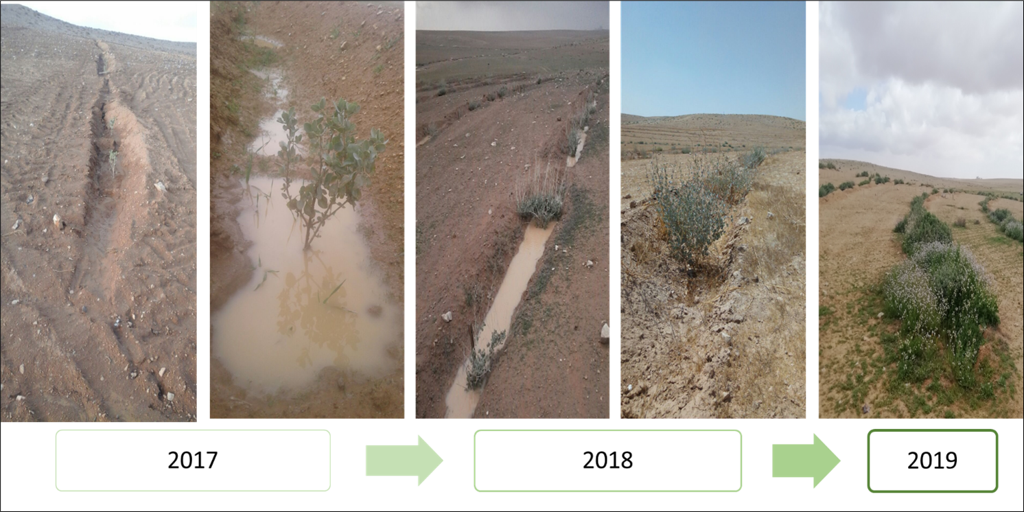
Mechanized micro water harvesting breaks up crusted and compacted soils, and fosters the capture and retention and the deep-infiltration of surface runoff generated during heavy rainfall events. The micro water harvesting pits store water and provide soil moisture to the out-planted shrub seedlings and the emerging seeds - and thus boosts the development of resilient vegetation patches towards the eventual rehabilitation of degraded rangelands.
2.2 Descripción detallada de la Tecnología
Descripción:
The micro water harvesting technology is part of a larger watershed rehabilitation initiative; It is the most upstream technology used in an integrated approach, including upland rehabilitation (Vallerani), gully erosion control, and revegetation (gully plugs), and downstream local barley agriculture using the ‘Marab’ technology.
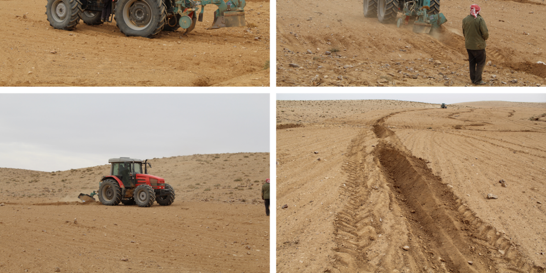
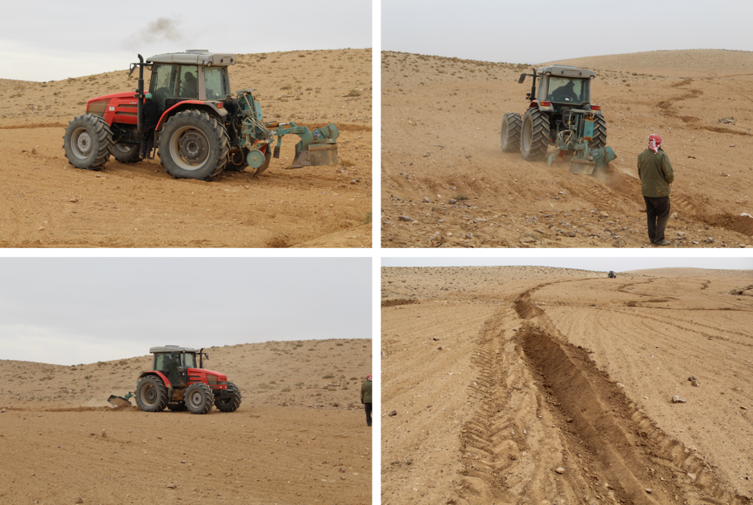
1: Main Elements: The Vallerani tractor plow (Delfino 50 MI/CM) (Gammoh & Oweis, 2011) constructs intermittent water harvesting pits along the contour of terrain and transects the hill slopes at approximately 5-10 m between lines. The local hill slope (at the implementation site) ranges between 2% and 15%. Pit length is adjustable and relates to the speed of the tractor. At the implementation site, pit lengths are around 4.5 m. In the micro water harvesting pits, several native shrub seedlings can be out-planted (at the site, 2 per pit).
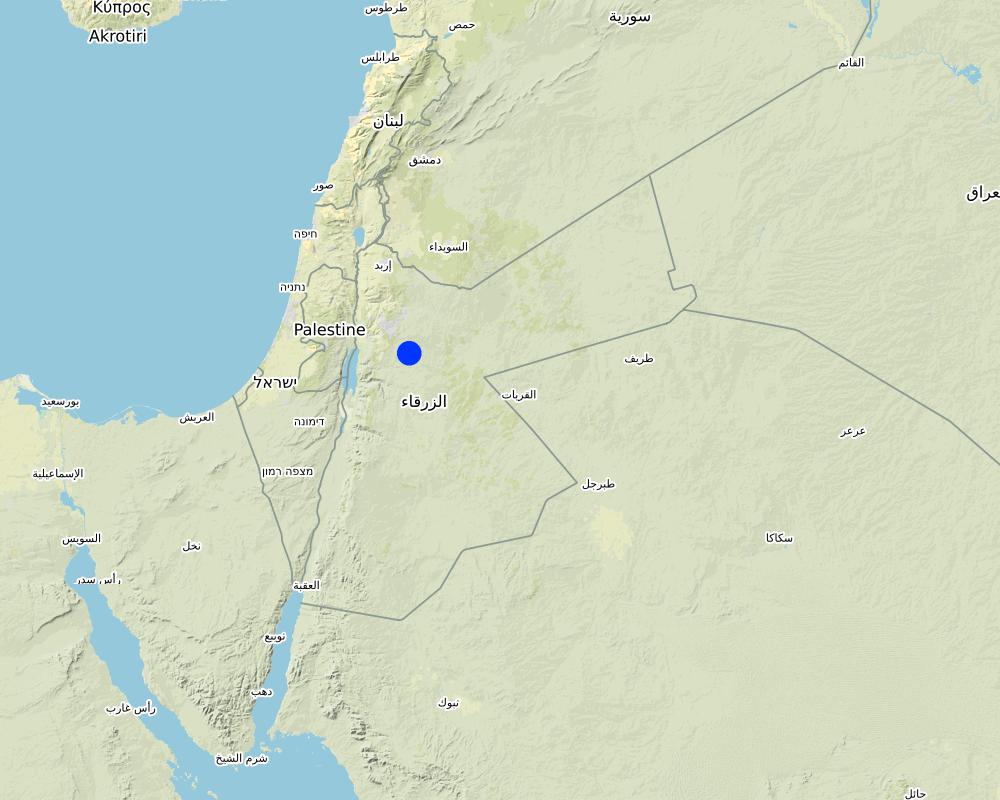
2: Where: This technology is used in a watershed context close to Al Majeddyeh village, located in the Middle Badia zone, approximately 30 km south-east of Amman. The climate is arid and warm (Palmer, 2013). The average annual rainfall is around 130 mm. The natural environment is classified as steppe, Bsh in the köppen classification. The human environment is characterized by agropastoralists. They are semi-nomadic and live in villages around the watershed, for example, Al Majeddyeh village.
3: The purpose of the technology: Breaking the land degradation cycle by retaining and encouraging deep-infiltration of surface runoff, which supports native vegetation growth. The stored soil moisture boosts the growth of both out-planted shrub seedlings and emerging local seeds towards healthy and resilient vegetation patches. Over time, the plowed pits degrade, but vegetation takes over the dryland hydrological functions of rainfall interception, runoff deceleration, and fostering infiltration. The developing shrubland provides various ecosystem services, predominately fodder for livestock of local agropastoralists.
4: Major activities: 1) Mechanized micro water harvesting establishment through the Vallerani tractor plow. 2) plantation of native seedlings in the pits (2 shrubs per pit at the local site). 3) Manage rangelands through sustainable grazing.
5: Impact: The technology breaks up the degradation cycle, increases soil moisture, and eventually boosts vegetation development and biodiversity. Through retention of runoff, sediments and residues, it decreases erosion and enhances organic carbon storage. It reduces peak surface runoff and thus mitigates flooding. The enhanced biomass supports livestock (grazing) and reduces agricultural inputs required (such as those required for low input barley production).
6: Land users' opinion: Land users evaluate the technology ambivalently. In the short term, landowners are often skeptical, because the rehabilitation requires a recovery time and strict non-grazing/resting for (usually) the first 2 rainy seasons. Thereafter, the rehabilitated lands require sustainable management. Later, after vegetation development, most landowners are convinced of the improvements and understand the economic and environmental value. The acceptance strongly depends on the social and cultural context – many farmers continue preferring the already established barley monoculture, mainly due to lack of sustainable rangeland management options and land ownership. However, well-targeted awareness campaigns can be supportive.
2.3 Fotografías de la Tecnología
Galería de medios

2.5 País/ región/ lugares donde la Tecnología fue aplicada y que se hallan comprendidos por esta evaluación
País:
Jordania
Región/ Estado/ Provincia:
Amman governorates /Al Jiza District/Al Majeddyeh Village
Especifique más el lugar :
Al Majeddyeh Village
Especifique la difusión de la Tecnología:
- distribuida parejamente sobre un área
Si la Tecnología se halla difundida homogéneamente a lo largo de un área, especifique el área que cubre (en km2):
30,0
¿El/los sitio(s) de la Tecnología se ubica(n) en un área de protección permanente?
No
Map
×2.6 Fecha de la implementación
Indique año de implementación:
2016
2.7 Introducción de la Tecnología
Especifique cómo se introdujo la Tecnología:
- durante experimentos/ investigación
- mediante proyectos/ intervenciones externas
Comentarios (tipo de proyecto, etc.):
This specific project was serving as a basis for SLM introduction and was launched in 2016.
The Vallerani Plough was locally tested in earlier projects.
The Vallerani Plough in Badia rehabilitation context was first introduced in Syria in 2004-2007.
3. Clasificación de la Tecnología MST
3.1 Propósito(s) principal(es) de la Tecnología MST
- mejorar la producción
- reducir, prevenir, restaurar la degradación de la tierra
- conservar el ecosistema
- proteger una cuenca hidrográfica/ áreas corriente abajo – en combinación con otras Tecnologías
- adaptarse al cambio climático/ extremos climáticos y sus impactos
3.2 Tipo(s) actuales de uso de la tierra donde se aplica la Tecnología
Mezcla de tipos de uso de tierras dentro de la misma unidad de tierras: :
No

Tierra de pastoreo
Pastoreo extenso:
- Pastoralismo semi-nómada
Pastoreo intensivo/ producción de forraje:
- Pastoreo mejorado
- Grazing Management plan
Tipo de animal:
- cabras
- ovejas
¿Se practica el manejo integrado de cultivos - ganado?
Sí
Si fuera el caso, especifique :
crop and livestock farming combined
- So far, the site opened for grazing after 2 years of protection in Oct.-Nov. 2018, Oct.- Nov. 2019, as well as April and Nov. 2020
Especies:
cabras
Conteo:
300
Especies:
ovejas
Conteo:
50

Otros
Especifique:
Restoration
Comentarios:
Planting of native shrub species: Atriplex Halimus, Retama, and Salsola.
3.3 ¿Cambió el uso de tierras debido a la implementación de la Tecnología?
¿Cambió el uso de tierras debido a la implementación de la Tecnología?
- No (Continúe con la pregunta 3.4)
3.4 Provisión de agua
Provisión de agua para la tierra donde se aplica la Tecnología:
- de secano
Comentarios:
The technology harvests surface runoff of erratic and heavy rainstorms
3.5 Grupo MST al que pertenece la Tecnología
- cobertura de suelo/ vegetal mejorada
- medida de pendiente transversal
- cosecha de agua
3.6 Medidas MST que componen la Tecnología

medidas agronómicas
- A4: Tratamiento de subsuperficie
- A6: Manejo de residuos

medidas vegetativas
- V2: Pastos y plantas herbáceas perennes
- V5: Otros

medidas estructurales
- S2: Taludes, bancos
- S11: Otros

medidas de manejo
- M2: Cambio de gestión/ nivel de intensidad
- M3: disposición de acuerdo al entorno natural y humano
- M4: Cambios significativos en la programación de las actividades
- M5: Control/ cambio de composición de las especies
- M7: Otros
otras medidas
Especifique:
Specify tillage system: reduced tillage (> 30% soil cover)
Specify residue management: grazed
Comments/ remarks: Vegetation biomass is used as fodder for livestock as well as retained (for recruitment) – managed through a sustainable grazing plan. The technology consists of a combination of structural and re-vegetative measures. The structural measure provides the opportunity for vegetation development beyond the out-planted species.
Comentarios:
Native shrubs (fodder shrubs) planted in the water harvesting pits.
Intermittent pits constructed by the Vallerani Plough
Management (grazing) plan after implementation
3.7 Principales tipos de degradación de la tierra encarados con la Tecnología

erosión de suelos por agua
- Wt: pérdida de capa arable/ erosión de la superficie
- Wg: erosión en cárcavas
- Wo: efectos de degradación fuera del sitio

erosión de suelos por viento
- Et: pérdida de capa arable
- Ed; deflación y deposición
- Eo; efectos de degradación fuera del sitio:

deterioro químico del suelo
- Cn: reducción de la fertilidad y contenido reducido de la materia orgánica del suelo (no ocasionados por la erosión)

deterioro físico del suelo
- Pc: compactación
- Pk: desmoronamiento y encostramiento

degradación biológica
- Bc: reducción de la cobertura vegetal del suelo
- Bh: pérdida de hábitats
- Bs: reducción en la calidad y composición/ diversidad de las especies
- Bl: pérdida de la vida del suelo

degradación del agua
- Ha: aridificación
- Hs: cambio en la cantidad de aguas superficiales
Comentarios:
Degradation is mainly caused by over-exploitation of vegetation (overgrazing), mechanized agriculture (ploughing and barley seeding) – but accelerated by climate change.
3.8 Prevención, reducción o restauración de la degradación de la tierra
Especifique la meta de la Tecnología con relación a la degradación de la tierra:
- reducir la degradación de la tierra
- restaurar/ rehabilitar tierra severamente degradada
4. Especificaciones técnicas, actividades de implementación, insumos y costos
4.1 Dibujo técnico de la Tecnología
Especificaciones técnicas (relacionadas al dibujo técnico):
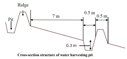
The dimensions of the water harvesting pits, constructed by the Vallerani tractor plow, are 4.5m, 0.5m, and 0.3m in length, width, and depth. With those dimensions, the effective water capturing total volume of one pit reaches approximately 0.2 to 0.3 m3 – depending on the formation process (e.g., depending on terrain, local soil, tractor speed). The interspace between the contours of water harvesting pits (in downslope direction) is approximately 7 meters at the implementation site. However, interspace strongly varies due to local terrain, soil, and rainfall pattern. The lateral spacing between pits is around 0.5m-1.0m.
Two local shrub seedlings of either Atriplex Halimus, Retama, or Salsola have been out-planted in the pit. These plants are native (adapted to the local environment) and drought tolerant. However, the early stage seedlings are vulnerable, and micro water harvesting substantially increases survival and fast development and allows the cumulation of top-soil, residues, and seed material.
At the specific site, micro water harvesting was established on slopes varying between 2% and 15%. The local rehabilitated area is around 10 hectares large. Around 1500 pits have been developed corresponding to 3000 planted shrub seedlings.
Autor:
Sayo Fukai
Fecha:
01/11/2019
4.2 Información general sobre el cálculo de insumos y costos
Especifique cómo se calcularon los costos e insumos:
- por área de Tecnología
Indique tamaño y unidad de área:
1ha
Especifique la moneda usada para calcular costos:
- USD
4.3 Actividades de establecimiento
| Actividad | Momento (estación) | |
|---|---|---|
| 1. | Site Selection (biophysical suitability) | At least 1 year prior implementation |
| 2. | Site inspection & local community consultation (social assessment, awareness and planning) | Around 1 year prior implementation |
| 3. | Ploughing of micro water harvesting pits along the contour (e.g. laser guided) | Late dry season (at least 1 month prior rainy season onset) |
| 4. | Out-planting of native shrubs seedlings (e.g. Atriplex and Ratameh) – potentially community inclusive activity | After first substantial rainfall (e.g. > 5mm rainfall event) |
| 5. | Sustainable management by the local community (grazing and resting plan) | Approximately after 2 years (sustainable grazing includes certain resting – chance for seeds production and recruitment) |
4.4 Costos e insumos necesarios para el establecimiento
| Especifique insumo | Unidad | Cantidad | Costos por unidad | Costos totales por insumo | % de los costos cubiertos por los usuarios de las tierras | |
|---|---|---|---|---|---|---|
| Mano de obra | Tractor plough operation | Labour Day per hectare | 0,2 | 25,0 | 5,0 | |
| Mano de obra | Technical assistance | LD | 0,2 | 50,0 | 10,0 | |
| Mano de obra | Seedling planters (local community) | LD | 5,0 | 20,0 | 100,0 | |
| Equipo | Tractor + Vallerani Plough (transport & fuel) | Day | 0,2 | 200,0 | 40,0 | |
| Equipo | Field equipment | Day | 1,0 | 20,0 | 20,0 | |
| Material para plantas | Atriplex Halimus | Seedling | 100,0 | 0,5 | 50,0 | |
| Material para plantas | Retama | Seedling | 100,0 | 0,5 | 50,0 | |
| Material para plantas | Salsola | Seedling | 100,0 | 0,5 | 50,0 | |
| Otros | Transportation and storage (e.g. seedlings) | Lumpsum per hectare | 1,0 | 20,0 | 20,0 | |
| Costos totales para establecer la Tecnología | 345,0 | |||||
| Costos totales para establecer la Tecnología en USD | 345,0 | |||||
Comentarios:
The shrub seedlings used were of high quality. A local community was used for labour. These two items increase costs per hectare – costs per hectare can be significantly reduced using ‘cheap’ seedlings or professional agricultural labour. However, the purpose of the project was local community inclusion and their benefit.
4.5 Actividades de establecimiento/ recurrentes
| Actividad | Momento/ frequencia | |
|---|---|---|
| 1. | Sustainable grazing (take half / leave half concept) | 1-2 times per season |
| 2. | Cut and carry | locally |
| 3. | Resting for shrub-seed production and new recruitment | Some selected resting seasons |
4.6 Costos e insumos necesarios para actividades de mantenimiento/ recurrentes (por año)
Comentarios:
The technology aims at re-establishing a sustainable nature-based ecosystem. Once properly implemented and managed, no further maintenance is needed. Certainly, ‘costs’ during biomass facilitation accrue through, e.g., herding and watering of livestock; however, these costs are not considered to occur because of the landscape improvement.
4.7 Factores más determinantes que afectan los costos:
Describa los factores más determinantes que afectan los costos:
The most important cost is the high-quality seedlings and the local labor costs. Both can be reduced.
5. Entorno natural y humano
5.1 Clima
Lluvia anual
- < 250 mm
- 251-500 mm
- 501-750 mm
- 751-1,000 mm
- 1,001-1,500 mm
- 1,501-2,000 mm
- 2,001-3,000 mm
- 3,001-4,000 mm
- > 4,000 mm
Especifique el promedio anual de lluvia (si lo conoce), en mm:
130,00
Especificaciones/ comentarios sobre la cantidad de lluvia:
Jordan has a rainy season from September to May – but locally, the effective rainy season sets on later (November or December) and lasts until April.
The average annual rainfall on-site for the recent three years is approximately 130 mm.
Indique el nombre de la estación metereológica de referencia considerada:
Queen Alia international airport reference station reports long term average annual rainfall of about 150 mm A rainfall tipping bucket installed in the site in 2016.
Zona agroclimática
- árida
The maximum temperature usually occurred between July and August.
The average daily maximum temperature is 25.01 °C.
The average daily minimum temperature is 8.5 °C
5.2 Topografía
Pendientes en promedio:
- plana (0-2 %)
- ligera (3-5%)
- moderada (6-10%)
- ondulada (11-15%)
- accidentada (16-30%)
- empinada (31-60%)
- muy empinada (>60%)
Formaciones telúricas:
- meseta/ planicies
- cordilleras
- laderas montañosas
- laderas de cerro
- pies de monte
- fondo del valle
Zona altitudinal:
- 0-100 m s.n.m.
- 101-500 m s.n.m.
- 501-1,000 m s.n.m
- 1,001-1,500 m s.n.m
- 1,501-2,000 m s.n.m
- 2,001-2,500 m s.n.m
- 2,501-3,000 m s.n.m
- 3,001-4,000 m s.n.m
- > 4,000 m s.n.m
Indique si la Tecnología se aplica específicamente en:
- no relevante
Comentarios y especificaciones adicionales sobre topografía :
Site topography ranges from 853 to 910 m above sea level (ASL), with an average slope steepness of 7.4 %.
5.3 Suelos
Profundidad promedio del suelo:
- muy superficial (0-20 cm)
- superficial (21-50 cm)
- moderadamente profunda (51-80 cm)
- profunda (81-120 cm)
- muy profunda (>120 cm)
Textura del suelo (capa arable):
- mediana (limosa)
Textura del suelo (> 20 cm debajo de la superficie):
- mediana (limosa)
Materia orgánica de capa arable:
- baja (<1%)
Si se halla disponible, adjunte una descripción completa de los suelos o especifique la información disponible, por ej., tipo de suelo, pH/ acidez de suelo, capacidad de intercambio catiónico, nitrógeno, salinidad, etc. :
The soil texture ranges from silty clay to silty clay loam.
Soil pH ranges from 8 – 8.5.
The soil is not saline.
5.4 Disponibilidad y calidad de agua
Agua subterránea:
> 50 m
Disponibilidad de aguas superficiales:
pobre/ ninguna
Calidad de agua (sin tratar):
inutilizable
La calidad de agua se refiere a:
agua subterránea
¿La salinidad del agua es un problema?
No
¿Se está llevando a cabo la inundación del área? :
Sí
Frecuencia:
frecuentemente
5.5 Biodiversidad
Diversidad de especies:
- elevada
Diversidad de hábitats:
- elevada
Comentarios y especificaciones adicionales sobre biodiversidad:
Atriplex, Ratameh and Salsola were actively out-planted (native species). This is not very biodiverse, but the evolving micro-habitat within the water harvesting pit allows emergence of collected seeds and consequential development of biodiverse vegetation patches
5.6 Las características de los usuarios de la tierra que aplican la Tecnología
Sedentario o nómada:
- Sedentario
- Semi-nómada
Orientación del mercado del sistema de producción:
- mixta (subsistencia/ comercial)
Ingresos no agrarios:
- menos del 10% de todos los ingresos
Nivel relativo de riqueza:
- pobre
- promedio
Individuos o grupos:
- individual/ doméstico
Nivel de mecanización:
- mecanizado/motorizado
Género:
- hombres
Edad de los usuarios de la tierra:
- jóvenes
- personas de mediana edad
Indique otras características relevantes de los usuarios de las tierras:
The actual landowners and users are often poor Jordanians. However, the owners of the large livestock flocks (potential facilitators of the rehabilitated lands) are comparatively rich.
5.7 Área promedio de la tierra usada por usuarios de tierra que aplican la Tecnología
- < 0.5 ha
- 0.5-1 ha
- 1-2 ha
- 2-5 ha
- 5-15 ha
- 15-50 ha
- 50-100 ha
- 100-500 ha
- 500-1,000 ha
- 1,000-10,000 ha
- > 10,000 ha
¿Esto se considera de pequeña, mediana o gran escala (refiriéndose al contexto local)?
- escala mediana
5.8 Tenencia de tierra, uso de tierra y derechos de uso de agua
Tenencia de tierra:
- individual, con título
Derechos de uso de tierra:
- individual
- NA
¿Los derechos del uso de la tierra se basan en un sistema legal tradicional?
Sí
5.9 Acceso a servicios e infraestructura
salud:
- pobre
- moderado
- bueno
educación:
- pobre
- moderado
- bueno
asistencia técnica:
- pobre
- moderado
- bueno
empleo (ej. fuera de la granja):
- pobre
- moderado
- bueno
mercados:
- pobre
- moderado
- bueno
energía:
- pobre
- moderado
- bueno
caminos y transporte:
- pobre
- moderado
- bueno
agua potable y saneamiento:
- pobre
- moderado
- bueno
servicios financieros:
- pobre
- moderado
- bueno
6. Impactos y comentarios para concluir
6.1 Impactos in situ demostrados por la Tecnología
Impactos socioeconómicos
Producción
producción de forraje
calidad de forraje
producción animal
diversidad de producto
manejo de tierras
Ingreso y costos
gastos en insumos agrícolas
carga de trabajo
Impactos socioculturales
seguridad alimentaria/ autosuficiencia
oportunidades recreativas
MST/ conocimiento de la degradación de la tierra
Impactos ecológicos
Ciclo de agua/ escurrimiento de sedimento
cantidad de agua
cosecha/ recolección de agua
escurrimiento superficial
evaporación
Suelo
humedad del suelo
cubierta del suelo
pérdida de suelo
acumulación de suelo
encostramiento/ sellado de suelo
materia orgánica debajo del suelo C
Biodiversidad: vegetación, animales
Cubierta vegetal
biomasa/ sobre suelo C
diversidad vegetal
especies invasoras extrañas
diversidad de hábitats
Reducción de riesgos de desastres y riesgos climáticos
impactos de inundaciones
impactos de ciclones, tormentas de lluvia
micro-clima
6.2 Impactos fuera del sitio demostrados por la Tecnología
corriente confiable y estable fluye en estación seca
inundaciones río abajo
colmatación río abajo
sedimentos transportados por el viento
6.3 Exposición y sensibilidad de la Tecnología al cambio climático gradual y a extremos relacionados al clima/ desastres (desde la percepción de los usuarios de tierras)
Cambio climático gradual
Cambio climático gradual
| Estación | Incremento o reducción | ¿Cómo es que la tecnología soporta esto? | |
|---|---|---|---|
| temperatura anual | incrementó | muy bien | |
| lluvia anual | disminuyó | muy bien |
Extremos (desastres) relacionados al clima
Desastres climatológicos:
| ¿Cómo es que la tecnología soporta esto? | |
|---|---|
| tormenta de lluvia local | muy bien |
Desastres climatológicos
| ¿Cómo es que la tecnología soporta esto? | |
|---|---|
| condiciones extremas de invierno | muy bien |
Desastres hidrológicos
| ¿Cómo es que la tecnología soporta esto? | |
|---|---|
| inundación repentina | muy bien |
6.4 Análisis costo-beneficio
¿Cómo se comparan los beneficios con los costos de establecimiento (desde la perspectiva de los usuarios de tierra)?
Ingresos a corto plazo:
ligeramente negativo
Ingresos a largo plazo:
positivo
¿Cómo se comparan los beneficios con los costos de mantenimiento/ recurrentes (desde la perspectiva de los usuarios de tierra)?
Ingresos a corto plazo:
muy positivo
Ingresos a largo plazo:
muy positivo
6.5 Adopción de la Tecnología
- 1-10%
De todos quienes adoptaron la Tecnología, ¿cuántos lo hicieron espontáneamente, por ej. sin recibir nada de incentivos/ materiales:
- 11-50%
6.6 Adaptación
¿La tecnología fue modificada recientemente para adaptarse a las condiciones cambiantes?
Sí
otros (especifique):
watershed approach and transition status of the structures
Especifique la adaptación de la Tecnología (diseño, material/ especies, etc.):
Implementation efficiency increase through adding contour laser technique and using the reversible blade (2 directions plowing)
6.7 Fuerzas/ ventajas/ oportunidades de la Tecnología
| Fuerzas/ ventajas/ oportunidades desde la perspectiva del usuario de la tierra |
|---|
| Opportunity for agro-pastoralism (grazing up to twice a year) |
| Improved livestock health, milk quantity, and quality. |
| No input costs needed (compared with e.g. barley agriculture) |
| Flexibility in timing: grazing of healthy rangelands can be done ‘at any time’(certainly spring season is most beneficial for livestock) – which differs from barley agriculture approach. |
| Fuerzas/ ventajas/ oportunidades desde la perspectiva del compilador o de otra persona de referencia clave |
|---|
| Besides out-planting of native shrub seedlings, native biodiversity evolves through the emergence of dormant seed material. |
| Out-planted shrub seedlings withstand extreme weather conditions (droughts) through water harvesting. The survival rate and eventual success of the rehabilitation approach are high. |
| Micro water harvesting structures and upcoming vegetation patches reduce erosion and increase trapping of sediments, including organic carbon and seed materials. |
| Water harvesting reduces the peak of surface runoff and thus mitigates downstream flooding |
6.8 Debilidades/ desventajas/ riesgos de la Tecnología y formas de sobreponerse a ellos
| Debilidades/ desventajas/ riesgos desde la perspectiva del usuario de la tierra | ¿Cómo sobreponerse a ellas? |
|---|---|
| Costs of implementation and availability of high-quality seedlings and the Vallerani plow. | Develop large-scale procedure/initiative that allows farmers to request and restore vulnerable areas using the Vallerani micro-water harvesting technique. Include incentives for implementation (ex. free seedlings, free of charge using of Vallerani machine, subsidies on arley as fodder for the first two years in order for farmers to maintain the site) |
| Change: Not all farmers are willing to forgo barley agriculture | Demonstrating the effects this technology through pilot projects. Local communities on the forefront of communication. |
| Vegetation growth may attract herders from different areas. | Clear rules and legislation on land facilitation in terms of grazing. |
| Requires higher understanding of the environment and long-term planning | Introduce knowledge sharing events to teach local farmers on the effects of land degradation and the benefits of healthy ecosystems |
| Debilidades/ desventajas/ riesgos desde la perspectiva del compilador o de otra persona de referencia clave | ¿Cómo sobreponerse a ellas? |
|---|---|
| Land ownership: current land tenure system in Jordan slows the adoption of the intervention. A landowner can reside in a city (no much value for the land), and the land user may be a herder. A large flock owner can rent huge areas for barley cultivation (actual cost of 1 donum of barley plantation ranges between 1.5-3 USD; possible to prepare up to 10 ha per day). Cheap labor/herders will move flocks and graze until all cover is gone (usually for 1-3 months maximum per year (March-May)). Rehabilitated areas will be of less interest for such users. | Develop and apply strict land management plans and policies. Create a strong monitoring system. Apply penalties for actions that increase land degradation with various on-site and off-sites impacts |
| Lack of institutional collaboration for rangeland management and rehabilitation. Land management in the Badia is the responsibility of several ministries in Jordan. The lack of institutional collaboration and the absence of the rangeland areas' valuation create a difficult environment for sustainability measures. | Increase the collaboration between ministries and stakeholders. Evaluate the impact of restoration solutions on the site and off site. |
| Lack of clear government policy for restoration, incentives for farmers, and funding availability. | Develop a clear action plan among the responsible government institutions of restoration activities. |
| Complex social context. The majority of land users and/or landowners don’t value the restoration. The bare cultivation practices have more (quick) value without resting time. | Capacity development for local communities for the value of soil, water, and biodiversity |
7. Referencias y vínculos
7.1 Métodos/ fuentes de información
- visitas de campo, encuestas de campo
15
- entrevistas con usuarios de tierras
2
- entrevistas con especialistas/ expertos en MST
4
- compilación de informes y otra documentación existente
¿Cuándo se compilaron los datos (en el campo)?
15/02/2020
7.2 Vínculos a las publicaciones disponibles
Título, autor, año, ISBN:
Akroush, S., & All, E. (2016). Factors Affecting the Adoption of Water Harvesting Technologies: A Case Study of Jordanian Arid Area. Sustainable Agriculture Research.
Título, autor, año, ISBN:
Akroush, S., & Boubaker, D. (2015). Predicted Willingness of Farmers to Adopt Water Harvesting Technologies: A Case Study from the Jordanian Badia (Jordan). American-Eurasian J. Agricultural & Environmental science , 1502-1513.
Título, autor, año, ISBN:
Gammoh, & Oweis. (2011). Performance and Adaptation of the Vallerani Mechanized Water Harvesting System in Degraded Badia Rangelands . Journal of Environmental Science and Engineering, 1370-1380.
Título, autor, año, ISBN:
Haddad, M. (2019). Exploring Jordan's Rangeland Transition: Merging Restoration Eperiment with Modeling - A Case study from Al Majdiyya Village. Amman: The University of Jordan.
Título, autor, año, ISBN:
Vallerani. (n.d.). Vallerani system. Retrieved from Vallerani: http://www.vallerani.com/wp/
7.3 Vínculos a la información relevante disponible en línea
Título/ descripción:
VALLERANI MICRO WATER HARVESTING
URL:
https://www.icarda.org/impact/impact-stories/vallerani-micro-water-harvesting
Título/ descripción:
CONTOUR LASER GUIDING FOR THE MECHANIZED “VALLERANI” MICRO-CATCHMENT WATER HARVESTING SYSTEMS
URL:
https://www.icarda.org/publications/10291/contour-laser-guiding-mechanized-vallerani-micro-catchment-water-harvesting
7.4 Comentarios generales
The Marab is a local downstream water harvesting measure in an integrated watershed context, where up/midstream users and applied land management practices affect the Marab.
The technology diverts and spreads excess runoff over deep-soil flood plains. The technology comprises local gully-filling, grading/leveling of seedbed, and construction of a bund-and-spillway system creating several compartments for flood-irrigated agriculture.
For more information please visit: https://qcat.wocat.net/en/wocat/technologies/view/technologies_5770/
Vínculos y módulos
Expandir todo Colapsar todosVínculos
No hay vínculos
Módulos
No se hallaron módulos