Mechanized micro water harvesting through ‘Vallerani’ tractor plough for central Jordanian Badia [ຈໍແດນ]
- ການສ້າງ:
- ປັບປູງ:
- ຜູ້ສັງລວມຂໍ້ມູນ: Mira Haddad
- ບັນນາທິການ: –
- ຜູ້ທົບທວນຄືນ: William Critchley, Rima Mekdaschi Studer
Vallerani (تقنية حصاد المياه بالمساقط الصغيرة (الفاليراني)
technologies_5860 - ຈໍແດນ
ເບິ່ງພາກສ່ວນ
ຂະຫຍາຍທັງໝົດ ຍຸບທັງໝົດ1. ຂໍ້ມູນທົ່ວໄປ
1.2 ຂໍ້ມູນ ການຕິດຕໍ່ພົວພັນ ຂອງບຸກຄົນທີ່ສໍາຄັນ ແລະ ສະຖາບັນ ທີ່ມີສ່ວນຮ່ວມ ໃນການປະເມີນເອກກະສານ ເຕັກໂນໂລຢີ
ບັນດາຜູ້ຕອບແບບສອບຖາມທີ່ສໍາຄັນ ()
Third Year Bachelor Student: International Land and Water Management:
ຜຸ້ຊ່ຽວຊານ ດ້ານການຄຸ້ມຄອງ ທີ່ດິນແບບຍືນຍົງ:
Strohmeier Stefan
International Center of Agriculture Research in the Dry Areas (ICARDA)
ຈໍແດນ
ຜຸ້ຊ່ຽວຊານ ດ້ານການຄຸ້ມຄອງ ທີ່ດິນແບບຍືນຍົງ:
ຊື່ສະຖາບັນ (ຫຼາຍສະຖາບັນ) ທີ່ອໍານວຍຄວາມສະດວກ ໃນການສ້າງເອກກະສານ / ປະເມີນ ເຕັກໂນໂລຢີ (ຖ້າກ່ຽວຂ້ອງ)
International Center for Agricultural Research in the Dry Areas (ICARDA) - ລີບານອນ1.3 ເງື່ອນໄຂ ກ່ຽວກັບ ການນໍາໃຊ້ຂໍ້ມູນເອກະສານ ທີ່ສ້າງຂື້ນ ໂດຍຜ່ານ ອົງການພາບລວມຂອງໂລກ ທາງດ້ານແນວທາງ ແລະ ເຕັກໂນໂລຢີ ຂອງການອານຸລັກ ທໍາມະຊາດ (WOCAT)
ຜູ້ປ້ອນຂໍ້ມູນ ແລະ ບຸກຄົນສຳຄັນ ທີ່ໃຫ້ຂໍ້ມູນ (ຫຼາຍ) ຍິນຍອມ ຕາມເງື່ອນໄຂ ໃນການນຳໃຊ້ຂໍ້ມູນ ເພື່ອສ້າງເປັນເອກກະສານຂອງ WOCAT:
ແມ່ນ
1.4 ແຈ້ງການວ່າ ດ້ວຍຄວາມຍືນຍົງຂອງ ເຕັກໂນໂລຢີ
ການນໍາໃຊ້ ເຕັກໂນໂລຢີ ດັ່ງກ່າວໄດ້ອະທິບາຍ ເຖິງບັນຫາ ກ່ຽວກັບ ການເຊື່ອມໂຊມຂອງດິນບໍ? ຖ້າບໍ່ດັ່ງນັ້ນ ມັນບໍ່ສາມາດ ຢັ້ງຢືນໄດ້ວ່າ ເປັນເຕັກໂນໂລຊີ ໃນການຄຸ້ມຄອງ ທີ່ດິນແບບຍືນຍົງ? :
ບໍ່ແມ່ນ
ຄວາມຄິດເຫັນ:
The technology supports the rehabilitation of degraded rangelands; the Vallerani plough forms micro water harvesting pits suitable for native shrub seedlings. This boosts vegetation recovery through both out-planted shrubs and the emergence of local seeds.
2. ການອະທິບາຍ ເຕັກໂນໂລຢີ ຂອງການຄຸ້ມຄອງ ທີ່ດິນແບບຍືນຍົງ
2.1 ຄໍາອະທິບາຍສັ້ນຂອງ ເຕັກໂນໂລຢີ
ການກຳໜົດຄວາມໝາຍ ຂອງເຕັກໂນໂລຢີ:
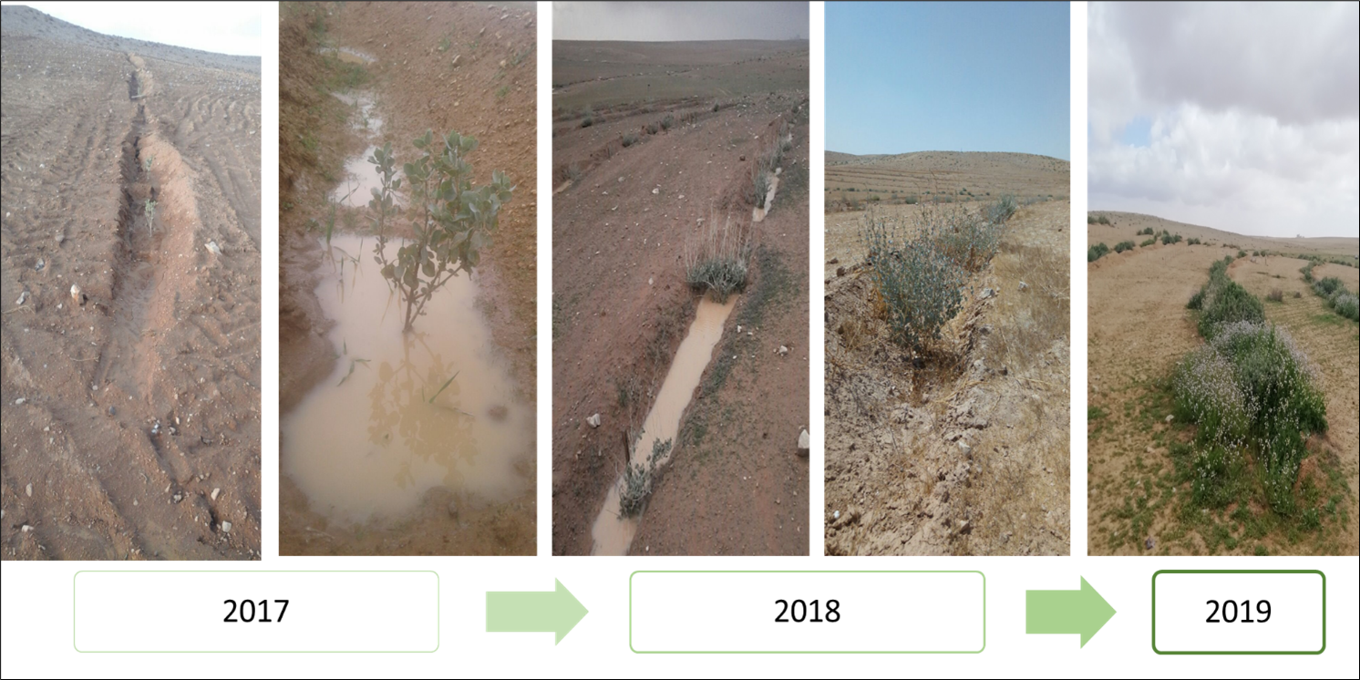
Mechanized micro water harvesting breaks up crusted and compacted soils, and fosters the capture and retention and the deep-infiltration of surface runoff generated during heavy rainfall events. The micro water harvesting pits store water and provide soil moisture to the out-planted shrub seedlings and the emerging seeds - and thus boosts the development of resilient vegetation patches towards the eventual rehabilitation of degraded rangelands.
2.2 ການອະທິບາຍ ລາຍລະອຽດ ຂອງເຕັກໂນໂລຢີ
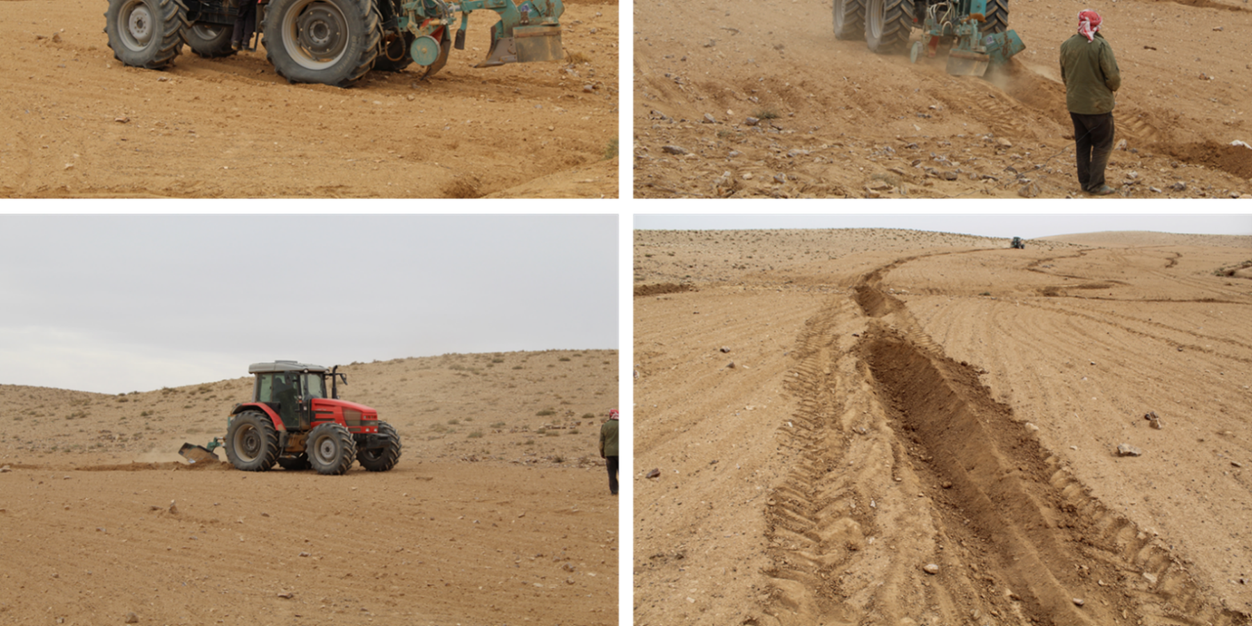
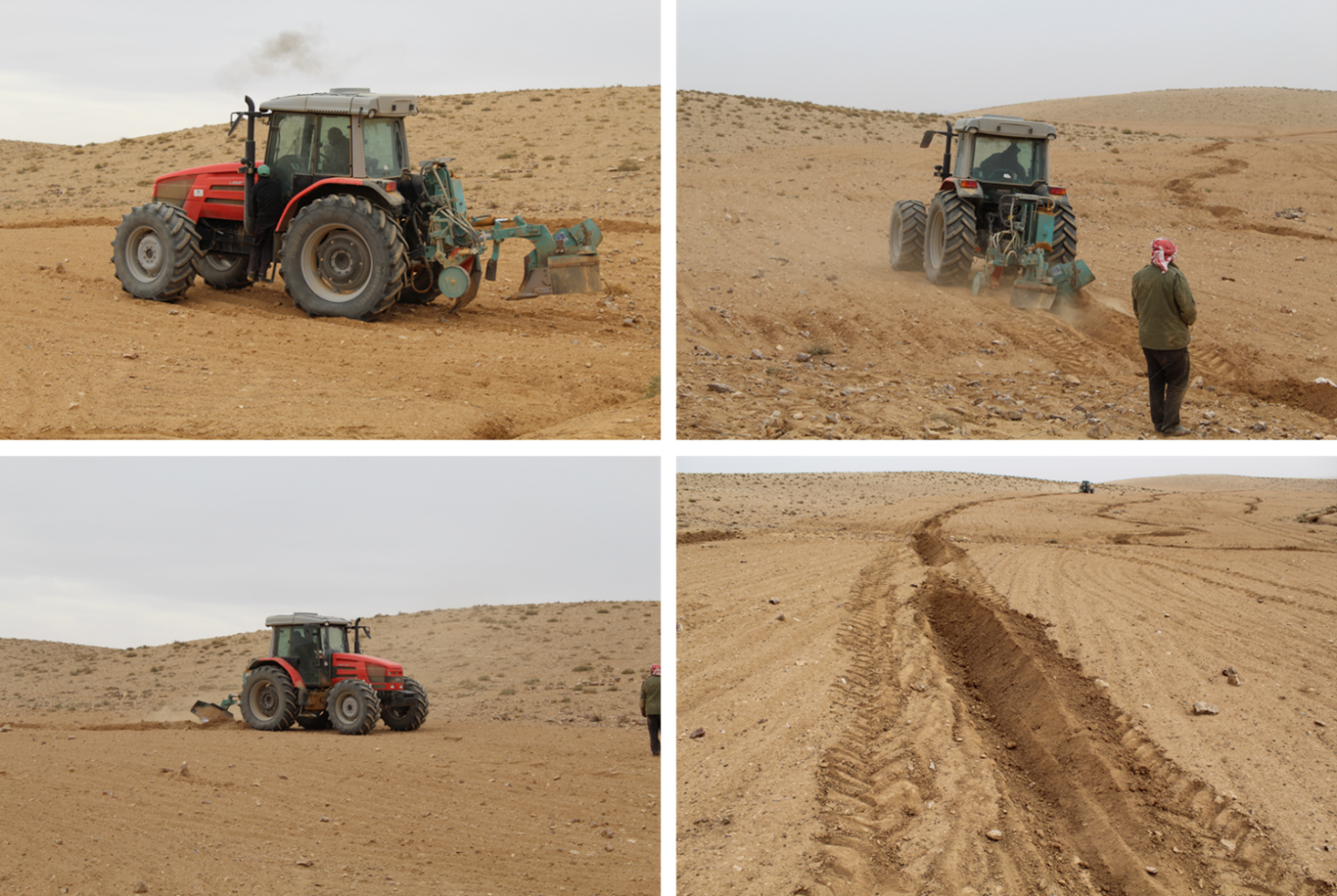
ການພັນລະນາ:
The micro water harvesting technology is part of a larger watershed rehabilitation initiative; It is the most upstream technology used in an integrated approach, including upland rehabilitation (Vallerani), gully erosion control, and revegetation (gully plugs), and downstream local barley agriculture using the ‘Marab’ technology.
1: Main Elements: The Vallerani tractor plow (Delfino 50 MI/CM) (Gammoh & Oweis, 2011) constructs intermittent water harvesting pits along the contour of terrain and transects the hill slopes at approximately 5-10 m between lines. The local hill slope (at the implementation site) ranges between 2% and 15%. Pit length is adjustable and relates to the speed of the tractor. At the implementation site, pit lengths are around 4.5 m. In the micro water harvesting pits, several native shrub seedlings can be out-planted (at the site, 2 per pit).
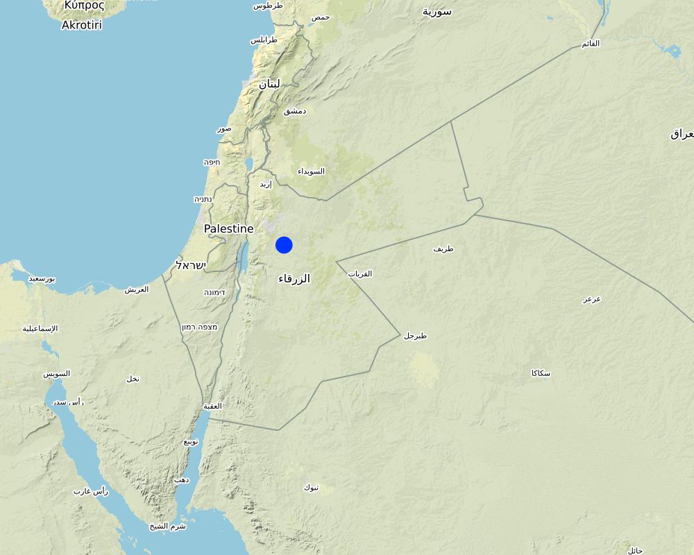
2: Where: This technology is used in a watershed context close to Al Majeddyeh village, located in the Middle Badia zone, approximately 30 km south-east of Amman. The climate is arid and warm (Palmer, 2013). The average annual rainfall is around 130 mm. The natural environment is classified as steppe, Bsh in the köppen classification. The human environment is characterized by agropastoralists. They are semi-nomadic and live in villages around the watershed, for example, Al Majeddyeh village.
3: The purpose of the technology: Breaking the land degradation cycle by retaining and encouraging deep-infiltration of surface runoff, which supports native vegetation growth. The stored soil moisture boosts the growth of both out-planted shrub seedlings and emerging local seeds towards healthy and resilient vegetation patches. Over time, the plowed pits degrade, but vegetation takes over the dryland hydrological functions of rainfall interception, runoff deceleration, and fostering infiltration. The developing shrubland provides various ecosystem services, predominately fodder for livestock of local agropastoralists.
4: Major activities: 1) Mechanized micro water harvesting establishment through the Vallerani tractor plow. 2) plantation of native seedlings in the pits (2 shrubs per pit at the local site). 3) Manage rangelands through sustainable grazing.
5: Impact: The technology breaks up the degradation cycle, increases soil moisture, and eventually boosts vegetation development and biodiversity. Through retention of runoff, sediments and residues, it decreases erosion and enhances organic carbon storage. It reduces peak surface runoff and thus mitigates flooding. The enhanced biomass supports livestock (grazing) and reduces agricultural inputs required (such as those required for low input barley production).
6: Land users' opinion: Land users evaluate the technology ambivalently. In the short term, landowners are often skeptical, because the rehabilitation requires a recovery time and strict non-grazing/resting for (usually) the first 2 rainy seasons. Thereafter, the rehabilitated lands require sustainable management. Later, after vegetation development, most landowners are convinced of the improvements and understand the economic and environmental value. The acceptance strongly depends on the social and cultural context – many farmers continue preferring the already established barley monoculture, mainly due to lack of sustainable rangeland management options and land ownership. However, well-targeted awareness campaigns can be supportive.
2.3 ຮູບພາບຂອງເຕັກໂນໂລຢີ
ສື່ຮູບພາບ

2.5 ປະເທດ / ເຂດ / ສະຖານທີ່ບ່ອນທີ່ ເຕັກໂນໂລຢີ ໄດ້ຮັບການນໍາໃຊ້ ແລະ ທີ່ຖືກປົກຄຸມດ້ວຍການປະເມີນຜົນ
ປະເທດ:
ຈໍແດນ
ພາກພື້ນ / ລັດ / ແຂວງ:
Amman governorates /Al Jiza District/Al Majeddyeh Village
ຂໍ້ມູນເພີ່ມເຕີມຂອງສະຖານທີ່:
Al Majeddyeh Village
ໃຫ້ລະບຸ ການແຜ່ຂະຫຍາຍ ເຕັກໂນໂລຢີ:
- ແຜ່ຂະຫຍາຍຢ່າງໄວວາໃນພື້ນທີ່
ຖ້າຫາກວ່າເຕັກໂນໂລຢີ ໄດ້ກະຈາຍໄປທົ່ວພື້ນທີ່, ໃຫ້ລະບຸເນື້ອທີ່ ທີ່ຖືກປົກຄຸມ (ເປັນ ກິໂລຕາແມັດ):
30.0
ສ່ວນຫຼາຍສະຖານທີ່ຕັ້ງຂອງເຕັກໂນໂລຢີ ແມ່ນ ຢູ່ໃນເຂດພື້ນທີ່ສະຫງວນບໍ?
ບໍ່ແມ່ນ
Map
×2.6 ວັນທີໃນການຈັດຕັ້ງປະຕິບັດ
ໃຫ້ລະບຸປີ ໃນການຈັດຕັ້ງປະຕິບັດ:
2016
2.7 ການນໍາສະເໜີ ເຕັກໂນໂລຢີ
ໃຫ້ລະບຸ ເຕັກໂນໂລຢີ ໄດ້ຖືກຈັດຕັ້ງປະຕິບັດຄືແນວໃດ?
- ໃນໄລຍະການທົດລອງ / ການຄົ້ນຄວ້າ
- ໂດຍຜ່ານໂຄງການ / ການຊ່ວຍເຫຼືອຈາກພາຍນອກ
ຄວາມຄິດເຫັນ (ປະເພດ ໂຄງການ ແລະ ອື່ນໆ):
This specific project was serving as a basis for SLM introduction and was launched in 2016.
The Vallerani Plough was locally tested in earlier projects.
The Vallerani Plough in Badia rehabilitation context was first introduced in Syria in 2004-2007.
3. ການໃຈ້ແຍກ ເຕັກໂນໂລຢີ ໃນການຄຸ້ມຄອງ ດິນແບບຍືນຍົງ
3.1 ຈຸດປະສົງຫຼັກ (ຫຼາຍ) ຂອງເຕັກໂນໂລຢີ
- ປັບປຸງ ການຜະລິດ
- ຫຼຸດຜ່ອນ, ປ້ອງກັນ, ຟື້ນຟູ ການເຊື່ອມໂຊມຂອງດິນ
- ການອະນຸລັກ ລະບົບນິເວດ
- ປົກປັກຮັກສານໍ້າ / ນໍ້າພື້ນທີ່ - ປະສົມປະສານກັບ ເຕັກໂນໂລຢີອື່ນໆ
- ປັບຕົວຕໍ່ກັບການປ່ຽນແປງດິນຟ້າອາກາດ / ທີ່ຮ້າຍແຮງ ແລະ ຜົນກະທົບ
3.2 ປະເພດການນໍາໃຊ້ທີ່ດິນ ໃນປະຈຸບັນ() ທີ່ເຕັກໂນໂລຢີ ໄດ້ຖືກນໍາໃຊ້
ການນຳໃຊ້ທີ່ດິນ ປະສົມພາຍໃນພື້ນທີ່ດຽວກັນ:
ບໍ່ແມ່ນ

ທົ່ງຫຍ້າລ້ຽງສັດ
ການລ້ຽງສັດແບບປ່ອຍ ຕາມທຳມະຊາດ:
- ການລ້ຽງສັດແບບເຄີ່ງປ່ອຍ
ທົ່ງຫຍ້າລ້ຽງສັດແບບສຸມ / ການຜະລິດອາຫານສັດ:
- ປັບປຸງ ທົ່ງຫຍ້າ
- Grazing Management plan
ປະເພດສັດ:
- ແບ້
- ແກະ
ແມ່ນການເຝືກຄຸ້ມຄອງ ການປູກພືດປະສົມປະສານ ກັບການລ້ຽງສັດບໍ່?
ແມ່ນ
ຖ້າແມ່ນ, ໃຫ້ລະບຸແຈ້ງ:
crop and livestock farming combined
- So far, the site opened for grazing after 2 years of protection in Oct.-Nov. 2018, Oct.- Nov. 2019, as well as April and Nov. 2020
ສາຍພັນ:
ແບ້
ນັບ:
300
ສາຍພັນ:
ແກະ
ນັບ:
50

ອື່ນໆ
ລະບຸ ຊະນິດ:
Restoration
ຂໍ້ສັງເກດ:
Planting of native shrub species: Atriplex Halimus, Retama, and Salsola.
3.3 ການນຳໃຊ້ທີ່ດິນ ມີການປ່ຽນແປງຍ້ອນການຈັດຕັ້ງທົດລອງເຕັກໂນໂລຢີ ແມ່ນບໍ່?
ການນຳໃຊ້ທີ່ດິນ ມີການປ່ຽນແປງຍ້ອນການຈັດຕັ້ງທົດລອງເຕັກໂນໂລຢີ ແມ່ນບໍ່?
- ບໍ່ (ຕໍ່ເໜືອງກັບ ຄຳຖາມ 3.4)
3.4 ການສະໜອງນ້ຳ
ການສະໜອງນໍ້າ ໃນພື້ນທີ່ ທີ່ໄດ້ນໍາໃຊ້ ເຕັກໂນໂລຢີ:
- ນໍ້າຝົນ
ຄວາມຄິດເຫັນ:
The technology harvests surface runoff of erratic and heavy rainstorms
3.5 ການນໍາໃຊ້ເຕັກໂນໂລຢີ ທີ່ຢູ່ໃນກຸ່ມການຄຸ້ມຄອງ ທີ່ດິນແບບຍືນຍົງ
- ການປັບປຸງດິນ / ພືດຄຸມດິນ
- ມາດຕະການ ຕັດຂວາງ ກັບຄວາມຄ້ອຍຊັນ
- ການເກັບກັກນໍ້າ
3.6 ມາດຕະການ ການຄຸ້ມຄອງ ທີ່ດິນແບບຍືນຍົງ ປະກອບດ້ວຍ ເຕັກໂນໂລຢີ

ມາດຕະການ ທາງການກະສິກໍາ
- A4: ການບໍາລຸງ ປົກປັກຮັກສາ ຊັ້ນຮອງໜ້າດິນ
- A6: ການຈັດການສິ່ງເສດເຫຼືອ

ມາດຕະການ ທາງດ້ານພືດພັນ
- V2: ຫຍ້າ ແລະ ພືດສະໝູນໄພທີ່ເປັນໄມ້ຢືນຕົ້ນ
- V5: ອື່ນໆ

ມາດຕະການໂຄງສ້າງ
- S2: ຄັນຄຸ, ແຄມຕາຝັ່ງ
- S11: ອື່ນໆ

ມາດຕະການ ທາງດ້ານການຄຸ້ມຄອງ
- M2: ການປ່ຽນແປງ ການຈັດການຄຸ້ມຄອງ / ລະດັບຄວາມໜາແໜ້ນ
- M3: ອີງຕາມສະພາບແວດລ້ອມ ທາງທຳມະຊາດ ແລະ ມະນຸດ
- M4: ການປ່ຽນແປງ ໄລຍະເວລາ ໃນການຈັດຕັ້ງປະຕິບັດ ກິດຈະກໍາ
- M5: ການຄວບຄຸມ / ການປ່ຽນແປງຂອງອົງປະກອບຂອງຊະນິດ
- M7: ອື່ນໆ
ມາດຕະການອື່ນໆ
ລະບຸ ຊະນິດ:
Specify tillage system: reduced tillage (> 30% soil cover)
Specify residue management: grazed
Comments/ remarks: Vegetation biomass is used as fodder for livestock as well as retained (for recruitment) – managed through a sustainable grazing plan. The technology consists of a combination of structural and re-vegetative measures. The structural measure provides the opportunity for vegetation development beyond the out-planted species.
ຄວາມຄິດເຫັນ:
Native shrubs (fodder shrubs) planted in the water harvesting pits.
Intermittent pits constructed by the Vallerani Plough
Management (grazing) plan after implementation
3.7 ປະເພດດິນເຊື່ອມໂຊມ ຫຼັກທີ່ໄດ້ນໍາໃຊ້ ເຕັກໂນໂລຢີ

ດິນເຊາະເຈື່ອນ ໂດຍນໍ້າ
- Wt: ການສູນເສຍຊັ້ນໜ້າດິນ / ການເຊາະເຈື່ອນຜິວໜ້າດິນ
- Wg: ການເຊາະເຈື່ອນຮ່ອງນ້ຳ / ຫ້ວຍ
- Wo: ຜົນກະທົບ ຂອງການເຊື່ອມໂຊມ ຕໍ່ພື້ນທີ່ພາຍນອກ

ດິນເຊາະເຈື່ອນ ໂດຍລົມ
- ການສູນເສຍຊັ້ນໜ້າດິນ
- Ed: ການສູນເສຍຈາກລົມ ແລະ ການທັບຖົມ
- Eo: ຜົນກະທົບຈາກການເຊື່ອມໂຊມທາງອ້ອມ

ການເຊື່ອມໂຊມ ຂອງດິນ ທາງເຄມີ
- Cn: ຄວາມອຸດົມສົມບູນ ລົດໜ້ອຍຖອຍລົງ ແລະ ສານອິນຊີວັດຖຸລົດລົງ (ບໍ່ແມ່ນສາເຫດມາຈາກການເຊາະເຈື່ອນ)

ການເຊື່ອມໂຊມ ຂອງດິນ ທາງກາຍະພາບ
- Pc: ການອັດແໜ້ນ
- Pk: ການບັນເທົາ ແລະ ການປົກຄຸມຂອງເປືອກໂລກ

ການເຊື່ອມໂຊມ ທາງຊີວະພາບ
- Bc: ການຫຼຸດຜ່ອນການປົກຫຸ້ມຂອງພືດ
- Bh: ການສູນເສຍ ທີ່ຢູ່ອາໃສ ຂອງສິ່ງທີ່ມີຊິວິດ
- Bs: ຄຸນນະພາບ / ການອັດແໜ້ນ ຂອງສາຍພັນຫຼຸດລົງ
- Bl: ການສູນເສຍ ຈຸລິນຊີໃນດິນ

ການເຊື່ອມໂຊມ ຂອງນໍ້າ
- Ha: ສະພາບແຫ້ງແລ້ງ
- Hs: ການປ່ຽນແປງ ປະລິມານ ນໍ້າໜ້າດິນ
ຄວາມຄິດເຫັນ:
Degradation is mainly caused by over-exploitation of vegetation (overgrazing), mechanized agriculture (ploughing and barley seeding) – but accelerated by climate change.
3.8 ການປ້ອງກັນ, ການຫຼຸດຜ່ອນ, ຫຼືການຟື້ນຟູຂອງການເຊື່ອມໂຊມຂອງດິນ
ໃຫ້ລະບຸ ເປົ້າໝາຍ ເຕັກໂນໂລຢີ ທີ່ພົວພັນ ກັບຄວາມເຊື່ອມໂຊມຂອງດິນ:
- ຫຼຸດຜ່ອນການເຊື່ອມໂຊມຂອງດິນ
- ການຟື້ນຟູ / ຟື້ນຟູດິນທີ່ຊຸດໂຊມ
4. ຂໍ້ກໍາໜົດ, ກິດຈະກໍາການປະຕິບັດ, ວັດຖຸດິບ, ແລະຄ່າໃຊ້ຈ່າຍ
4.1 ເຕັກນິກ ໃນການແຕ້ມແຜນວາດ ເຕັກໂນໂລຢີ
ຄຸນລັກສະນະ ຂອງເຕັກນິກ (ທີ່ກ່ຽວຂ້ອງ ກັບການແຕ້ມແຜນວາດ ທາງດ້ານເຕັກນີກ):
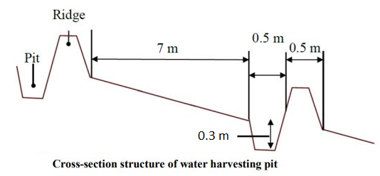
The dimensions of the water harvesting pits, constructed by the Vallerani tractor plow, are 4.5m, 0.5m, and 0.3m in length, width, and depth. With those dimensions, the effective water capturing total volume of one pit reaches approximately 0.2 to 0.3 m3 – depending on the formation process (e.g., depending on terrain, local soil, tractor speed). The interspace between the contours of water harvesting pits (in downslope direction) is approximately 7 meters at the implementation site. However, interspace strongly varies due to local terrain, soil, and rainfall pattern. The lateral spacing between pits is around 0.5m-1.0m.
Two local shrub seedlings of either Atriplex Halimus, Retama, or Salsola have been out-planted in the pit. These plants are native (adapted to the local environment) and drought tolerant. However, the early stage seedlings are vulnerable, and micro water harvesting substantially increases survival and fast development and allows the cumulation of top-soil, residues, and seed material.
At the specific site, micro water harvesting was established on slopes varying between 2% and 15%. The local rehabilitated area is around 10 hectares large. Around 1500 pits have been developed corresponding to 3000 planted shrub seedlings.
ຜູ້ຂຽນ:
Sayo Fukai
ວັນທີ:
01/11/2019
4.2 ຂໍ້ມູນທົ່ວໄປກ່ຽວກັບການຄິດໄລ່ປັດໃຈຂາເຂົ້າໃນການຜະລິດ ແລະ ມູນຄ່າອື່ນໆ
ລະບຸ ວິທີການ ຄຳໃຊ້ຈ່າຍ ແລະ ປັດໄຈນໍາເຂົ້າ ທີ່ໄດ້ຄິດໄລ່:
- ຕໍ່ພື້ນທີ່ ທີ່ໄດ້ຈັດຕັ້ງປະຕິບັດ ເຕັກໂນໂລຢີ
ໃຫ້ລະບຸຫົວໜ່ວຍ ຂະໜາດ ແລະ ເນື້ອທີ່:
1ha
ລະບຸ ສະກຸນເງິນທີ່ໃຊ້ສໍາລັບ ການຄິດໄລ່ຄ່າໃຊ້ຈ່າຍ:
- USA
4.3 ການສ້າງຕັ້ງກິດຈະກໍາ
| ກິດຈະກໍາ | Timing (season) | |
|---|---|---|
| 1. | Site Selection (biophysical suitability) | At least 1 year prior implementation |
| 2. | Site inspection & local community consultation (social assessment, awareness and planning) | Around 1 year prior implementation |
| 3. | Ploughing of micro water harvesting pits along the contour (e.g. laser guided) | Late dry season (at least 1 month prior rainy season onset) |
| 4. | Out-planting of native shrubs seedlings (e.g. Atriplex and Ratameh) – potentially community inclusive activity | After first substantial rainfall (e.g. > 5mm rainfall event) |
| 5. | Sustainable management by the local community (grazing and resting plan) | Approximately after 2 years (sustainable grazing includes certain resting – chance for seeds production and recruitment) |
4.4 ຕົ້ນທຶນ ແລະ ປັດໄຈຂາເຂົ້າທີ່ຈໍາເປັນໃນຈັດຕັ້ງປະຕິບັດ
| ລະບຸ ປັດໃຈ ນໍາເຂົ້າ ໃນການຜະລີດ | ຫົວໜ່ວຍ | ປະລິມານ | ຕົ້ນທຶນ ຕໍ່ຫົວໜ່ວຍ | ຕົ້ນທຶນທັງໝົດ ຂອງປັດໃຈຂາເຂົ້າ ໃນການຜະລິດ | % ຂອງຕົ້ນທຶນທັງໝົດ ທີ່ຜູ້ນໍາໃຊ້ທີ່ດິນ ໃຊ້ຈ່າຍເອງ | |
|---|---|---|---|---|---|---|
| ແຮງງານ | Tractor plough operation | Labour Day per hectare | 0.2 | 25.0 | 5.0 | |
| ແຮງງານ | Technical assistance | LD | 0.2 | 50.0 | 10.0 | |
| ແຮງງານ | Seedling planters (local community) | LD | 5.0 | 20.0 | 100.0 | |
| ອຸປະກອນ | Tractor + Vallerani Plough (transport & fuel) | Day | 0.2 | 200.0 | 40.0 | |
| ອຸປະກອນ | Field equipment | Day | 1.0 | 20.0 | 20.0 | |
| ວັດສະດຸໃນການປູກ | Atriplex Halimus | Seedling | 100.0 | 0.5 | 50.0 | |
| ວັດສະດຸໃນການປູກ | Retama | Seedling | 100.0 | 0.5 | 50.0 | |
| ວັດສະດຸໃນການປູກ | Salsola | Seedling | 100.0 | 0.5 | 50.0 | |
| ອື່ນໆ | Transportation and storage (e.g. seedlings) | Lumpsum per hectare | 1.0 | 20.0 | 20.0 | |
| ຕົ້ນທຶນທັງໝົດ ໃນການຈັດຕັ້ງປະຕິບັດ ເຕັກໂນໂລຢີ | 345.0 | |||||
| ຄ່າໃຊ້ຈ່າຍທັງໝົດ ສຳລັບການສ້າງຕັ້ງເຕັກໂນໂລຢີ ເປັນສະກຸນເງີນໂດລາ | 345.0 | |||||
ຄວາມຄິດເຫັນ:
The shrub seedlings used were of high quality. A local community was used for labour. These two items increase costs per hectare – costs per hectare can be significantly reduced using ‘cheap’ seedlings or professional agricultural labour. However, the purpose of the project was local community inclusion and their benefit.
4.5 ບໍາລຸງຮັກສາ / ແຜນຈັດຕັ້ງປະຕິບັດ ກິດຈະກໍາ
| ກິດຈະກໍາ | ໄລຍະເວລາ / ຄວາມຖີ່ | |
|---|---|---|
| 1. | Sustainable grazing (take half / leave half concept) | 1-2 times per season |
| 2. | Cut and carry | locally |
| 3. | Resting for shrub-seed production and new recruitment | Some selected resting seasons |
4.6 ຄ່າໃຊ້ຈ່າຍ ແລະ ປັດໄຈນໍາເຂົ້າທີ່ຈໍາເປັນສໍາລັບການບໍາລຸງຮັກສາກິດຈະກໍາ / ແຜນປະຕິບັດ (ຕໍ່ປີ)
ຄວາມຄິດເຫັນ:
The technology aims at re-establishing a sustainable nature-based ecosystem. Once properly implemented and managed, no further maintenance is needed. Certainly, ‘costs’ during biomass facilitation accrue through, e.g., herding and watering of livestock; however, these costs are not considered to occur because of the landscape improvement.
4.7 ປັດໄຈ ທີ່ສໍາຄັນ ທີ່ສົ່ງຜົນກະທົບ ຕໍ່ຄ່າໃຊ້ຈ່າຍ
ໃຫ້ອະທິບາຍ ປັດໃຈ ທີ່ສົ່ງຜົນກະທົບ ຕໍ່ຕົ້ນທຶນ ໃນການຈັດຕັ້ງປະຕິບັດ:
The most important cost is the high-quality seedlings and the local labor costs. Both can be reduced.
5. ສະພາບແວດລ້ອມທໍາມະຊາດ ແລະ ມະນຸດ
5.1 ອາກາດ
ປະລິມານນໍ້າຝົນປະຈໍາປີ
- < 250 ມີລິແມັດ
- 251-500 ມີລິແມັດ
- 501-750 ມີລິແມັດ
- 751-1,000 ມີລິແມັດ
- 1,001-1,500 ມີລິແມັດ
- 1,501-2,000 ມີລິແມັດ
- 2,001-3,000 ມີລິແມັດ
- 3,001-4,000 ມີລິແມັດ
- > 4,000 ມີລິແມັດ
ໃຫ້ລະບຸສະເລ່ຍ ປະລິມານນໍ້າຝົນຕົກປະຈໍາປີ ເປັນມິນລິແມັດ (ຖ້າຫາກຮູ້ຈັກ):
130.00
ຂໍ້ມູນສະເພາະ / ຄວາມເຫັນກ່ຽວກັບ ປະລິມານນໍ້າຝົນ:
Jordan has a rainy season from September to May – but locally, the effective rainy season sets on later (November or December) and lasts until April.
The average annual rainfall on-site for the recent three years is approximately 130 mm.
ໃຫ້ລະບຸ ຊື່ສະຖານີ ອຸຕຸນິຍົມ ເພື່ອເປັນຂໍ້ມູນອ້າງອີງ:
Queen Alia international airport reference station reports long term average annual rainfall of about 150 mm A rainfall tipping bucket installed in the site in 2016.
ເຂດສະພາບອາກາດກະສິກໍາ
- ແຫ້ງແລ້ງ
The maximum temperature usually occurred between July and August.
The average daily maximum temperature is 25.01 °C.
The average daily minimum temperature is 8.5 °C
5.2 ພູມິປະເທດ
ຄ່າສະເລ່ຍ ຄວາມຄ້ອຍຊັນ:
- ພື້ນທີ່ຮາບພຽງ (0-2%)
- ອ່ອນ (3-5 %)
- ປານກາງ (6-10 %)
- ມ້ວນ (11-15 %)
- ເນີນ(16-30%)
- ໍຊັນ (31-60%)
- ຊັນຫຼາຍ (>60%)
ຮູບແບບຂອງດິນ:
- ພູພຽງ / ທົ່ງພຽງ
- ສັນພູ
- ເປີ້ນພູ
- ເນີນພູ
- ຕີນພູ
- ຮ່ອມພູ
ເຂດລະດັບສູງ:
- 0-100 ແມັດ a.s.l.
- 101-500 ແມັດ a.s.l.
- 501-1,000 ແມັດ a.s.l.
- 1,001-1,500 ແມັດ a.s.l.
- 1,501-2,000 ແມັດ a.s.l.
- 2,001-2,500 ແມັດ a.s.l.
- 2,501-3,000 ແມັດ a.s.l.
- 3,001-4,000 ແມັດ a.s.l.
- > 4,000 ແມັດ a.s.l.
ໃຫ້ລະບຸ ເຕັກໂນໂລຢີ ທີ່ໄດ້ຖືກນຳໃຊ້:
- ບໍ່ກ່ຽວຂ້ອງ
ຄຳເຫັນ ແລະ ຂໍ້ມູນສະເພາະ ເພີ່ມເຕີມ ກ່ຽວກັບ ພູມີປະເທດ:
Site topography ranges from 853 to 910 m above sea level (ASL), with an average slope steepness of 7.4 %.
5.3 ດິນ
ຄວາມເລິກ ຂອງດິນສະເລ່ຍ:
- ຕື້ນຫຼາຍ (0-20 ຊັງຕີແມັດ)
- ຕື້ນ (21-50 ຊຕມ)
- ເລີກປານກາງ (51-80 ຊຕມ)
- ເລິກ (81-120 ຊມ)
- ເລິກຫຼາຍ (> 120 cm)
ເນື້ອດິນ (ໜ້າດິນ):
- ປານກາງ (ດິນໜຽວ, ດິນໂຄນ)
ເນື້ອດິນ (ເລິກຈາກໜ້າດິນ ລົງໄປຫຼາຍກວ່າ 20 ຊັງຕິແມັດ):
- ປານກາງ (ດິນໜຽວ, ດິນໂຄນ)
ຊັ້ນອິນຊີວັດຖຸ ເທິງໜ້າດິນ:
- ຕໍາ່ (<1 %)
ຖ້າເປັນໄປໄດ້ ແມ່ນໃຫ້ຕິດຄັດ ການພັນລະນາດິນ ຫຼື ຂໍ້ມູນສະເພາະຂອງດິນ, ຕົວຢ່າງ, ຄຸນລັກສະນະ ປະເພດຂອງດິນ, ຄ່າຄວາມເປັນກົດ / ເປັນດ່າງຂອງດິນ, ສານອາຫານ, ດິນເຄັມ ແລະ ອື່ນໆ.
The soil texture ranges from silty clay to silty clay loam.
Soil pH ranges from 8 – 8.5.
The soil is not saline.
5.4 ມີນໍ້າ ແລະ ຄຸນນະພາບ
ລະດັບ ນໍ້າໃຕ້ດິນ:
> 50 ແມັດ
ການມີນໍ້າ ເທິງໜ້າດິນ:
ທຸກຍາກ / ບໍ່ມີ
ຄຸນນະພາບນໍ້າ (ບໍ່ມີການບໍາບັດ):
ຜິດປົກກະຕິ
ຄຸນນະພາບນ້ຳ ໝາຍເຖີງ:
ນ້ຳໃຕ້ດິນ
ມີບັນຫາ ກ່ຽວກັບນໍ້າເຄັມບໍ່?
ບໍ່ແມ່ນ
ເກີດມີນໍ້າຖ້ວມ ໃນພື້ນທີ່ບໍ່?
ແມ່ນ
ເປັນປົກກະຕິ:
ເລື້ອຍໆ
5.5 ຊີວະນາໆພັນ
ຄວາມຫຼາກຫຼາຍ ທາງສາຍພັນ:
- ສູງ
ຄວາມຫຼາກຫຼາຍ ທາງດ້ານ ທີ່ຢູ່ອາໃສ ຂອງສິ່ງທີ່ມີຊີວິດ:
- ສູງ
ຄວາມຄິດເຫັນ ແລະ ລັກສະນະສະເພາະ ເພີ່ມເຕີມກ່ຽວກັບ ຊີວະນາໆພັນ:
Atriplex, Ratameh and Salsola were actively out-planted (native species). This is not very biodiverse, but the evolving micro-habitat within the water harvesting pit allows emergence of collected seeds and consequential development of biodiverse vegetation patches
5.6 ຄຸນລັກສະນະ ຂອງຜູ້ນໍາໃຊ້ທີ່ດິນ ທີ່ໄດ້ນໍາໃຊ້ເຕັກໂນໂລຢີ
ຢູ່ປະຈຳ ຫຼື ເຄື່ອນຍ້າຍຕະຫຼອດ:
- ບໍ່ເຄື່ອນໄຫວ
- ແບບເຄີ່ງຂັງ-ເຄີ່ງປ່ອຍ
ລະບົບ ການຕະຫຼາດ ແລະ ຜົນຜະລິດ:
- ປະສົມປົນເປ( ກຸ້ມຕົນເອງ/ເປັນສິນຄ້າ)
ລາຍຮັບ ທີ່ບໍ່ໄດ້ມາຈາກ ການຜະລິດ ກະສິກໍາ:
- ໜ້ອຍກ່ວາ 10 % ຂອງລາຍຮັບທັງໝົດ
ລະດັບຄວາມຮັ່ງມີ:
- ທຸກຍາກ
- ສະເລ່ຍ
ບຸກຄົນ ຫຼື ກຸ່ມ:
- ບຸກຄົນ / ຄົວເຮືອນ
ລະດັບ ການຫັນເປັນກົນຈັກ:
- ເຄື່ອງກົນຈັກ
ເພດ:
- ຜູ້ຊາຍ
ອາຍຸ ຂອງຜູ້ນໍາໃຊ້ທີ່ດິນ:
- ຊາວໜຸ່ມ
- ໄວກາງຄົນ
ໃຫ້ລະບຸ ຄຸນລັກສະນະ ຂອງຜູ້ນໍາໃຊ້ທີ່ດິນ:
The actual landowners and users are often poor Jordanians. However, the owners of the large livestock flocks (potential facilitators of the rehabilitated lands) are comparatively rich.
5.7 ເນື້ອທີ່ສະເລ່ຍຂອງດິນ ທີ່ຜູ້ນຳໃຊ້ທີ່ດິນ ໃຊ້ເຮັດເຕັກໂນໂລຢີ
- <0.5 ເຮັກຕາ
- 0.5-1 ເຮັກຕາ
- 1-2 ເຮັກຕາ
- 2-5 ເຮັກຕາ
- 5-15 ເຮັກຕາ
- 15-50 ເຮັກຕາ
- 50-100 ເຮັກຕາ
- 100-500 ເຮັກຕາ
- 500-1,000 ເຮັກຕາ
- 1,000-10,000 ເຮັກຕາ
- > 10,000 ເຮັກຕາ
ຖືໄດ້ວ່າ ເປັນຂະໜາດນ້ອຍ, ກາງ ຫຼື ໃຫຍ່ (ອີງຕາມເງື່ອນໄຂ ສະພາບຄວາມເປັນຈິງ ຂອງທ້ອງຖີ່ນ)? :
- ຂະໜາດກາງ
5.8 ເຈົ້າຂອງທີ່ດິນ, ສິດໃຊ້ທີ່ດິນ, ແລະ ສິດທິການນໍາໃຊ້ນໍ້າ
ເຈົ້າຂອງດິນ:
- ບຸກຄົນ, ທີ່ມີຕໍາແໜ່ງ
ສິດທິ ໃນການນໍາໃຊ້ທີ່ດິນ:
- ບຸກຄົນ
- NA
ສິດນຳໃຊ້ທີ່ດິນ ແມ່ນ ອີງໃສ່ລະບົບກົດໝາຍແບບດັ້ງເດີມບໍ?
ແມ່ນ
5.9 ການເຂົ້າເຖິງການບໍລິການ ແລະ ພື້ນຖານໂຄງລ່າງ
ສຸຂະພາບ:
- ທຸກຍາກ
- ປານກາງ
- ດີ
ການສຶກສາ:
- ທຸກຍາກ
- ປານກາງ
- ດີ
ການຊ່ວຍເຫຼືອ ດ້ານວິຊາການ:
- ທຸກຍາກ
- ປານກາງ
- ດີ
ການຈ້າງງານ (ຕົວຢ່າງ, ການເຮັດກິດຈະກໍາອື່ນ ທີ່ບໍ່ແມ່ນ ການຜະລິດກະສິກໍາ):
- ທຸກຍາກ
- ປານກາງ
- ດີ
ຕະຫຼາດ:
- ທຸກຍາກ
- ປານກາງ
- ດີ
ພະລັງງານ:
- ທຸກຍາກ
- ປານກາງ
- ດີ
ຖະໜົນຫົນທາງ ແລະ ການຂົນສົ່ງ:
- ທຸກຍາກ
- ປານກາງ
- ດີ
ການດື່ມນໍ້າ ແລະ ສຸຂາພິບານ:
- ທຸກຍາກ
- ປານກາງ
- ດີ
ການບໍລິການ ທາງດ້ານການເງິນ:
- ທຸກຍາກ
- ປານກາງ
- ດີ
6. ຜົນກະທົບ ແລະ ລາຍງານສະຫຼຸບ
6.1 ການສະແດງຜົນກະທົບ ພາຍໃນພື້ນທີ່ ທີ່ໄດ້ຈັດຕັ້ງປະຕິບັດ ເຕັກໂນໂລຢີ
ຜົນກະທົບທາງເສດຖະກິດສັງຄົມ
ການຜະລິດ
ການຜະລິດອາຫານສັດ
ຄຸນນະພາບຂອງອາຫານສັດ
ຜົນຜະລິດຂອງສັດ
ຄວາມໜາແໜ້ນ ຂອງຜົນຜະລິດ
ການຈັດການຄຸ້ມຄອງທີ່ດິນ
ລາຍໄດ້ ແລະ ຄ່າໃຊ້ຈ່າຍ
ຄ່າໃຊ້ຈ່າຍ ປັດໄຈນໍາເຂົ້າ ໃນການຜະລິດກະສິກໍາ
ມີວຽກໜັກ
ຜົນກະທົບດ້ານວັດທະນາທໍາສັງຄົມ
ການຄໍ້າປະກັນ ສະບຽງອາຫານ / ກຸ້ມຢູ່ກຸ້ມກິນ
ໂອກາດ ໃນການພັກຜ່ອນຢ່ອນໃຈ
ຄວາມຮູ້ກ່ຽວກັບ ການຄຸ້ມຄອງ ທີ່ດິນແບບຍືນຍົງ / ການເຊື່ອມໂຊມຂອງດິນ
ຜົນກະທົບຕໍ່ລະບົບນິເວດ
ວົງຈອນນໍ້າ / ນໍ້າ
ປະລິມານນໍ້າ
ການຂຸດຄົ້ນ / ການເກັບກັກນໍ້າ
ການໄຫຼ ຂອງນໍ້າໜ້າດິນ
ການລະເຫີຍອາຍ
ດິນ
ຄວາມຊຸ່ມຂອງດິນ
ການປົກຄຸມຂອງດິນ
ການສູນເສຍດິນ
ການທັບຖົມຂອງດິນ
ດິນເປັນຜົງ / ການຈັບໂຕຂອງດິນ ທີ່ມີຂະໜາດນ້ອຍຫຼາຍ ທີ່ມີການຈັບໂຕກັນເປັນກ້ອນ
ອິນຊີວັດຖຸໃນດິນ / ຢູ່ລຸ່ມຊັ້ນດິນ C
ຊີວະນານາພັນ: ສັດ, ພືດ
ການປົກຫຸ້ມຂອງພືດ
ມວນຊີວະພາບ / ຢູ່ເທິງຊັ້ນດິນ C
ຄວາມຫຼາກຫຼາຍຂອງພືດ
ສາຍພັນຕ່າງຖີ່ນ
ຄວາມຫຼາກຫຼາຍ ທາງດ້ານທີ່ຢູ່ອາໃສ ຂອງສິ່ງທີ່ມີຊີວິດ
ການຫຼຸດຜ່ອນ ຄວາມສ່ຽງ ຈາກໄພພິບັດ ແລະ ອາກາດປ່ຽນແປງ
ຜົນກະທົບ ຂອງນໍ້າຖ້ວມ
ຜົນກະທົບ ຂອງລົມພາຍຸໄຊໂຄນ, ພາຍຸຝົນຕົກໜັກ
ການປ່ຽນແປງ ອາກາດ ໃນວົງແຄບ
6.2 ຜົນກະທົບທາງອ້ອມ ຈາກການນໍາໃຊ້ເຕັກໂນໂລຢີ
ການໄຫຼຂອງນໍ້າໃນລະດູແລ້ງ
ນໍ້າຖ້ວມຢູ່ເຂດລຸ່ມນໍ້າ
ການທັບຖົມ ຂອງດິນຕະກອນ ຢູ່ເຂດລຸ່ມນໍ້າ
ລົມ ທີ່ພັດເອົາຕະກອນ
6.3 ການປ້ອງກັນ ແລະ ຄວາມບອບບາງ ຂອງເຕັກໂນໂລຢິ ໃນການປ່ຽນແປງສະພາບດິນຟ້າອາກາດ ແລະ ກ່ຽວຂ້ອງກັບອາກາດທີ່ມີການປ່ຽນແປງທີ່ຮຸນແຮງ / ໄພພິບັດທາງທໍາມະຊາດ (ຮັບຮູ້ໄດ້ໂດຍຜູ້ນໍາໃຊ້ທີ່ດິນ)
ການປ່ຽນແປງດິນຟ້າອາກາດ ເທື່ອລະກ້າວ
ການປ່ຽນແປງດິນຟ້າອາກາດ ເທື່ອລະກ້າວ
| ລະດູການ | ເພີ່ມຂື້ນ ຫຼື ຫຼຸດລົງ | ການນໍາໃຊ້ ເຕັກໂນໂລຢີ ສາມາດ ຮັບມື ໄດ້ຄືແນວໃດ? | |
|---|---|---|---|
| ອຸນຫະພູມປະຈໍາປີ | ເພີ່ມຂື້ນ | ດີຫຼາຍ | |
| ປະລິມານນໍ້າຝົນປະຈໍາປີ | ຫຼຸດລົງ | ດີຫຼາຍ |
ອາກາດ ທີ່ກ່ຽວພັນກັບຄວາມຮຸນແຮງ (ໄພພິບັດທາງທໍາມະຊາດ)
ໄພພິບັດທາງອຸຕຸນິຍົມ
| ການນໍາໃຊ້ ເຕັກໂນໂລຢີ ສາມາດ ຮັບມື ໄດ້ຄືແນວໃດ? | |
|---|---|
| ພະຍຸຝົນ | ດີຫຼາຍ |
ໄພພິບັດທາງພູມອາກາດ
| ການນໍາໃຊ້ ເຕັກໂນໂລຢີ ສາມາດ ຮັບມື ໄດ້ຄືແນວໃດ? | |
|---|---|
| ອາກາດໜາວຮຸນແຮງ | ດີຫຼາຍ |
ໄພພິບັດທາງອຸທົກກະສາກ
| ການນໍາໃຊ້ ເຕັກໂນໂລຢີ ສາມາດ ຮັບມື ໄດ້ຄືແນວໃດ? | |
|---|---|
| ນໍ້າຖ້ວມຮູນແຮງ | ດີຫຼາຍ |
6.4 ການວິເຄາະຕົ້ນທຶນ ແລະ ຜົນປະໂຫຍດ
ຈະເຮັດປະໂຫຍດເພື່ອປຽບທຽບກັບຄ່າໃຊ້ຈ່າຍກັບສິ່ງກໍ່ສ້າງ (ຈາກທັດສະນະຂອງຜູ້ນຳໃຊ້ທີ່ດິນ) ໄດ້ແນວໃດ?
ຜົນຕອບແທນ ໃນໄລຍະສັ້ນ:
ຜົນກະທົບທາງລົບເລັກນ້ອຍ
ຜົນຕອບແທນ ໃນໄລຍະຍາວ:
ຜົນກະທົບທາງບວກ
ຈະໄດ້ຮັບຜົນປະໂຫຍດເມື່ອປຽບທຽບກັບ / ຄ່າໃຊ້ຈ່າຍໃນການບຳລຸງຮັກສາທີເ່ກີດຂື້ນອິກ (ຈາກທັດສະນະຄະຕິຂອງຜູ້ນຳໃຊ້ທີ່ດິນ) ໄດ້ແນວໃດ?
ຜົນຕອບແທນ ໃນໄລຍະສັ້ນ:
ຜົນກະທົບທາງບວກຫຼາຍ
ຜົນຕອບແທນ ໃນໄລຍະຍາວ:
ຜົນກະທົບທາງບວກຫຼາຍ
6.5 ການປັບຕົວຮັບເອົາເຕັກໂນໂລຢີ
- 1-10%
ທັງໝົດນັ້ນ ແມ່ນໃຜ ໄດ້ປັບຕົວເຂົ້າ ໃນການນໍາໃຊ້ ເຕັກໂນໂລຢີ, ມີຈັກຄົນ ທີ່ສາມາດເຮັດເອງໄດ້, ຕົວຢ່າງ, ປາດສະຈາກ ການຊ່ວຍເຫຼືອ ທາງດ້ານອຸປະກອນ / ການຈ່າຍເປັນເງິນ?
- 11-50%
6.6 ການປັບຕົວ
ໄດ້ມີການດັດປັບ ເຕັກໂນໂລຢີ ເພື່ອໃຫ້ແທດເໝາະກັບເງື່ອນໄຂ ການປ່ຽນແປງບໍ?
ແມ່ນ
ອື່ນໆ (ລະບຸແຈ້ງ):
watershed approach and transition status of the structures
ລະບຸການຮັບຮອງເອົາ ເຕັກໂນໂລຢີ (ການອອກແບບ, ອຸປະກອນການ / ຊະນິດພັນ ແລະ ອື່ນໆ):
Implementation efficiency increase through adding contour laser technique and using the reversible blade (2 directions plowing)
6.7 ຈຸດແຂງ / ຂໍ້ດີ / ໂອກາດ ໃນການນໍາໃຊ້ ເຕັກໂນໂລຢີ
| ຈຸດແຂງ / ຂໍ້ດີ / ໂອກາດໃນການນໍາໃຊ້ທີ່ດິນ |
|---|
| Opportunity for agro-pastoralism (grazing up to twice a year) |
| Improved livestock health, milk quantity, and quality. |
| No input costs needed (compared with e.g. barley agriculture) |
| Flexibility in timing: grazing of healthy rangelands can be done ‘at any time’(certainly spring season is most beneficial for livestock) – which differs from barley agriculture approach. |
| ຈຸດແຂງ / ຈຸດດີ / ໂອກາດ ຈາກທັດສະນະຂອງຜູ້ປ້ອນຂໍ້ມູນ ຫຼື ບຸກຄົນສຳຄັນ |
|---|
| Besides out-planting of native shrub seedlings, native biodiversity evolves through the emergence of dormant seed material. |
| Out-planted shrub seedlings withstand extreme weather conditions (droughts) through water harvesting. The survival rate and eventual success of the rehabilitation approach are high. |
| Micro water harvesting structures and upcoming vegetation patches reduce erosion and increase trapping of sediments, including organic carbon and seed materials. |
| Water harvesting reduces the peak of surface runoff and thus mitigates downstream flooding |
6.8 ຈຸດອ່ອນ / ຂໍ້ເສຍ / ຄວາມສ່ຽງ ໃນການນໍາໃຊ້ ເຕັກໂນໂລຢີ ແລະ ວິທີການແກ້ໄຂບັນຫາ
| ຈຸດອ່ອນ / ຂໍ້ເສຍ / ຄວາມສ່ຽງໃນມຸມມອງຂອງຜູ້ນໍາໃຊ້ທີ່ດິນ | ມີວິທີການແກ້ໄຂຄືແນວໃດ? |
|---|---|
| Costs of implementation and availability of high-quality seedlings and the Vallerani plow. | Develop large-scale procedure/initiative that allows farmers to request and restore vulnerable areas using the Vallerani micro-water harvesting technique. Include incentives for implementation (ex. free seedlings, free of charge using of Vallerani machine, subsidies on arley as fodder for the first two years in order for farmers to maintain the site) |
| Change: Not all farmers are willing to forgo barley agriculture | Demonstrating the effects this technology through pilot projects. Local communities on the forefront of communication. |
| Vegetation growth may attract herders from different areas. | Clear rules and legislation on land facilitation in terms of grazing. |
| Requires higher understanding of the environment and long-term planning | Introduce knowledge sharing events to teach local farmers on the effects of land degradation and the benefits of healthy ecosystems |
| ຈຸດອ່ອນ/ຂໍ້ບົກຜ່ອງ/ຄວາມສ່ຽງ ຈາກທັດສະນະຂອງຜູ້ປ້ອນຂໍ້ມູນ ຫຼື ບຸກຄົນສຳຄັນ | ມີວິທີການແກ້ໄຂຄືແນວໃດ? |
|---|---|
| Land ownership: current land tenure system in Jordan slows the adoption of the intervention. A landowner can reside in a city (no much value for the land), and the land user may be a herder. A large flock owner can rent huge areas for barley cultivation (actual cost of 1 donum of barley plantation ranges between 1.5-3 USD; possible to prepare up to 10 ha per day). Cheap labor/herders will move flocks and graze until all cover is gone (usually for 1-3 months maximum per year (March-May)). Rehabilitated areas will be of less interest for such users. | Develop and apply strict land management plans and policies. Create a strong monitoring system. Apply penalties for actions that increase land degradation with various on-site and off-sites impacts |
| Lack of institutional collaboration for rangeland management and rehabilitation. Land management in the Badia is the responsibility of several ministries in Jordan. The lack of institutional collaboration and the absence of the rangeland areas' valuation create a difficult environment for sustainability measures. | Increase the collaboration between ministries and stakeholders. Evaluate the impact of restoration solutions on the site and off site. |
| Lack of clear government policy for restoration, incentives for farmers, and funding availability. | Develop a clear action plan among the responsible government institutions of restoration activities. |
| Complex social context. The majority of land users and/or landowners don’t value the restoration. The bare cultivation practices have more (quick) value without resting time. | Capacity development for local communities for the value of soil, water, and biodiversity |
7. ເອກະສານອ້າງອີງ ແລະ ການເຊື່ອມຕໍ່
7.1 ວິທີການ / ແຫຼ່ງຂໍ້ມູນ
- ການໄປຢ້ຽມຢາມພາກສະໜາມ, ການສໍາຫຼວດພາກສະໜາມ
15
- ການສໍາພາດ ຜູ້ນໍາໃຊ້ທີ່ດິນ
2
- ສໍາພາດ ຊ່ຽວຊານ ການຄຸ້ມຄອງ ດິນແບບຍືນຍົງ
4
- ການລວບລວມ ບົດລາຍງານ ແລະ ເອກະສານ ອື່ນໆ ທີ່ມີຢູ່ແລ້ວ
ເມື່ອໃດທີ່ໄດ້ສັງລວມຂໍ້ມູນ (ຢູ່ພາກສະໜາມ)?
15/02/2020
7.2 ເອກກະສານອ້າງອີງທີ່ເປັນບົດລາຍງານ
ຫົວຂໍ້, ຜູ້ຂຽນ, ປີ, ISBN:
Akroush, S., & All, E. (2016). Factors Affecting the Adoption of Water Harvesting Technologies: A Case Study of Jordanian Arid Area. Sustainable Agriculture Research.
ຫົວຂໍ້, ຜູ້ຂຽນ, ປີ, ISBN:
Akroush, S., & Boubaker, D. (2015). Predicted Willingness of Farmers to Adopt Water Harvesting Technologies: A Case Study from the Jordanian Badia (Jordan). American-Eurasian J. Agricultural & Environmental science , 1502-1513.
ຫົວຂໍ້, ຜູ້ຂຽນ, ປີ, ISBN:
Gammoh, & Oweis. (2011). Performance and Adaptation of the Vallerani Mechanized Water Harvesting System in Degraded Badia Rangelands . Journal of Environmental Science and Engineering, 1370-1380.
ຫົວຂໍ້, ຜູ້ຂຽນ, ປີ, ISBN:
Haddad, M. (2019). Exploring Jordan's Rangeland Transition: Merging Restoration Eperiment with Modeling - A Case study from Al Majdiyya Village. Amman: The University of Jordan.
ຫົວຂໍ້, ຜູ້ຂຽນ, ປີ, ISBN:
Vallerani. (n.d.). Vallerani system. Retrieved from Vallerani: http://www.vallerani.com/wp/
7.3 ເຊື່ອມຕໍ່ກັບຂໍ້ມູນທີ່ກ່ຽວຂ້ອງໂດຍກົງ
ຫົວຂໍ້ / ພັນລະນາ:
VALLERANI MICRO WATER HARVESTING
URL:
https://www.icarda.org/impact/impact-stories/vallerani-micro-water-harvesting
ຫົວຂໍ້ / ພັນລະນາ:
CONTOUR LASER GUIDING FOR THE MECHANIZED “VALLERANI” MICRO-CATCHMENT WATER HARVESTING SYSTEMS
URL:
https://www.icarda.org/publications/10291/contour-laser-guiding-mechanized-vallerani-micro-catchment-water-harvesting
7.4 ຄຳຄິດຄຳເຫັນທົ່ວໄປ
The Marab is a local downstream water harvesting measure in an integrated watershed context, where up/midstream users and applied land management practices affect the Marab.
The technology diverts and spreads excess runoff over deep-soil flood plains. The technology comprises local gully-filling, grading/leveling of seedbed, and construction of a bund-and-spillway system creating several compartments for flood-irrigated agriculture.
For more information please visit: https://qcat.wocat.net/en/wocat/technologies/view/technologies_5770/
ຂໍ້ມູນການເຊື່ອມຕໍ່ ແລະ ເນື້ອໃນ
ຂະຫຍາຍທັງໝົດ ຍຸບທັງໝົດການເຊື່ອມຕໍ່
ບໍ່ມີຂໍ້ມູນການເຊື່ອມຕໍ່
ເນື້ອໃນ
ບໍ່ມີເນື້ອໃນ