Mechanized micro water harvesting through ‘Vallerani’ tractor plough for central Jordanian Badia [Jordanie]
- Création :
- Mise à jour :
- Compilateur : Mira Haddad
- Rédacteur : –
- Examinateurs : William Critchley, Rima Mekdaschi Studer
Vallerani (تقنية حصاد المياه بالمساقط الصغيرة (الفاليراني)
technologies_5860 - Jordanie
Voir les sections
Développer tout Réduire tout1. Informations générales
1.2 Coordonnées des personnes-ressources et des institutions impliquées dans l'évaluation et la documentation de la Technologie
Personne(s)-ressource(s) clé(s)
Third Year Bachelor Student: International Land and Water Management:
Spécialiste GDT:
Strohmeier Stefan
International Center of Agriculture Research in the Dry Areas (ICARDA)
Jordanie
Spécialiste GDT:
Nom du ou des institutions qui ont facilité la documentation/ l'évaluation de la Technologie (si pertinent)
International Center for Agricultural Research in the Dry Areas (ICARDA) - Liban1.3 Conditions relatives à l'utilisation par WOCAT des données documentées
Le compilateur et la(les) personne(s) ressource(s) acceptent les conditions relatives à l'utilisation par WOCAT des données documentées:
Oui
1.4 Déclaration sur la durabilité de la Technologie décrite
Est-ce que la Technologie décrite ici pose problème par rapport à la dégradation des terres, de telle sorte qu'elle ne peut pas être déclarée comme étant une technologie de gestion durable des terres?
Non
Commentaires:
The technology supports the rehabilitation of degraded rangelands; the Vallerani plough forms micro water harvesting pits suitable for native shrub seedlings. This boosts vegetation recovery through both out-planted shrubs and the emergence of local seeds.
2. Description de la Technologie de GDT
2.1 Courte description de la Technologie
Définition de la Technologie:
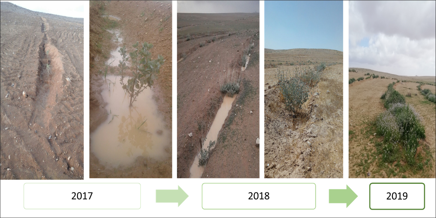
Mechanized micro water harvesting breaks up crusted and compacted soils, and fosters the capture and retention and the deep-infiltration of surface runoff generated during heavy rainfall events. The micro water harvesting pits store water and provide soil moisture to the out-planted shrub seedlings and the emerging seeds - and thus boosts the development of resilient vegetation patches towards the eventual rehabilitation of degraded rangelands.
2.2 Description détaillée de la Technologie
Description:
The micro water harvesting technology is part of a larger watershed rehabilitation initiative; It is the most upstream technology used in an integrated approach, including upland rehabilitation (Vallerani), gully erosion control, and revegetation (gully plugs), and downstream local barley agriculture using the ‘Marab’ technology.
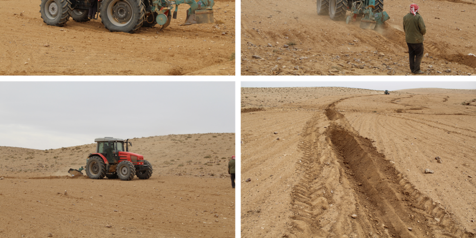
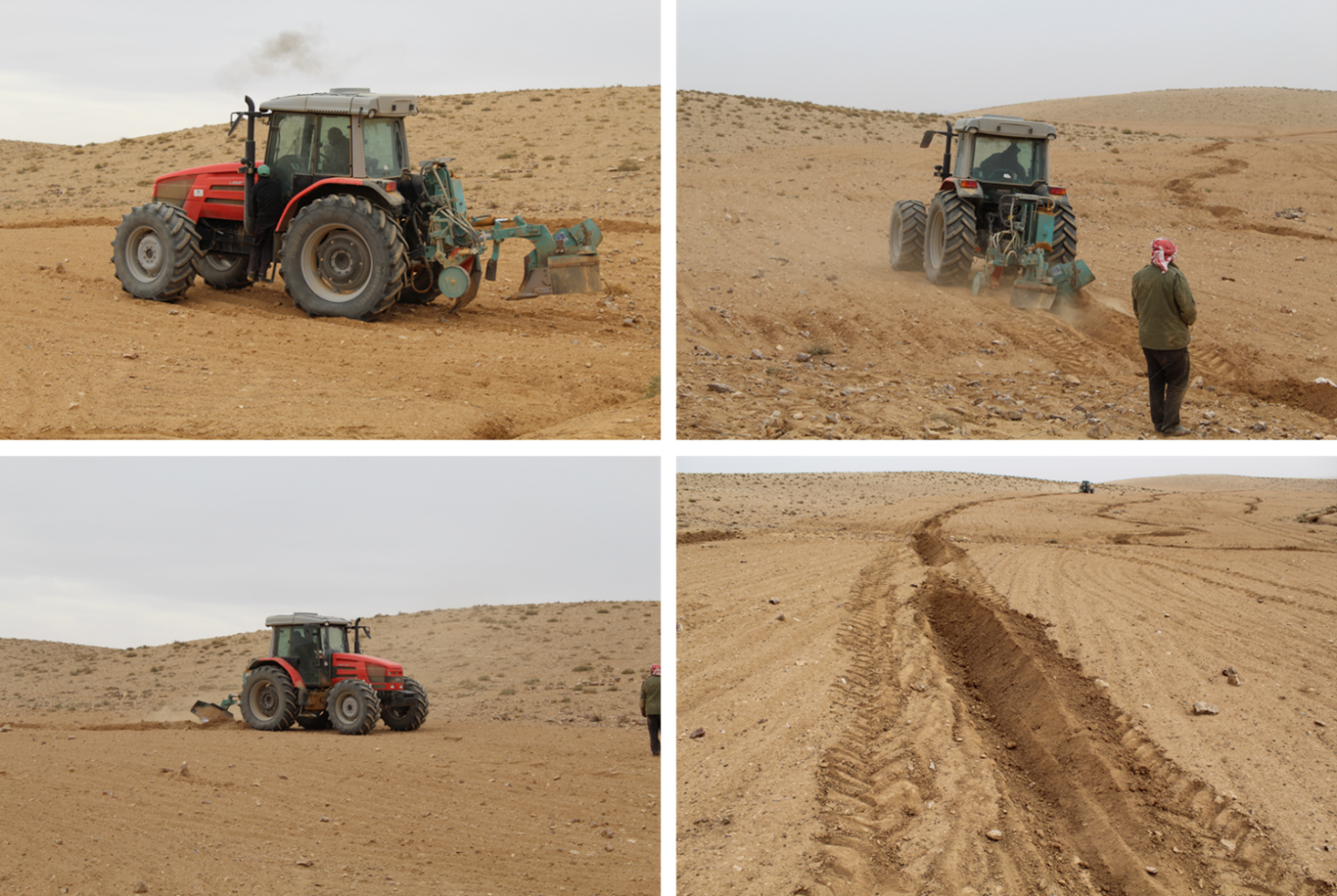
1: Main Elements: The Vallerani tractor plow (Delfino 50 MI/CM) (Gammoh & Oweis, 2011) constructs intermittent water harvesting pits along the contour of terrain and transects the hill slopes at approximately 5-10 m between lines. The local hill slope (at the implementation site) ranges between 2% and 15%. Pit length is adjustable and relates to the speed of the tractor. At the implementation site, pit lengths are around 4.5 m. In the micro water harvesting pits, several native shrub seedlings can be out-planted (at the site, 2 per pit).
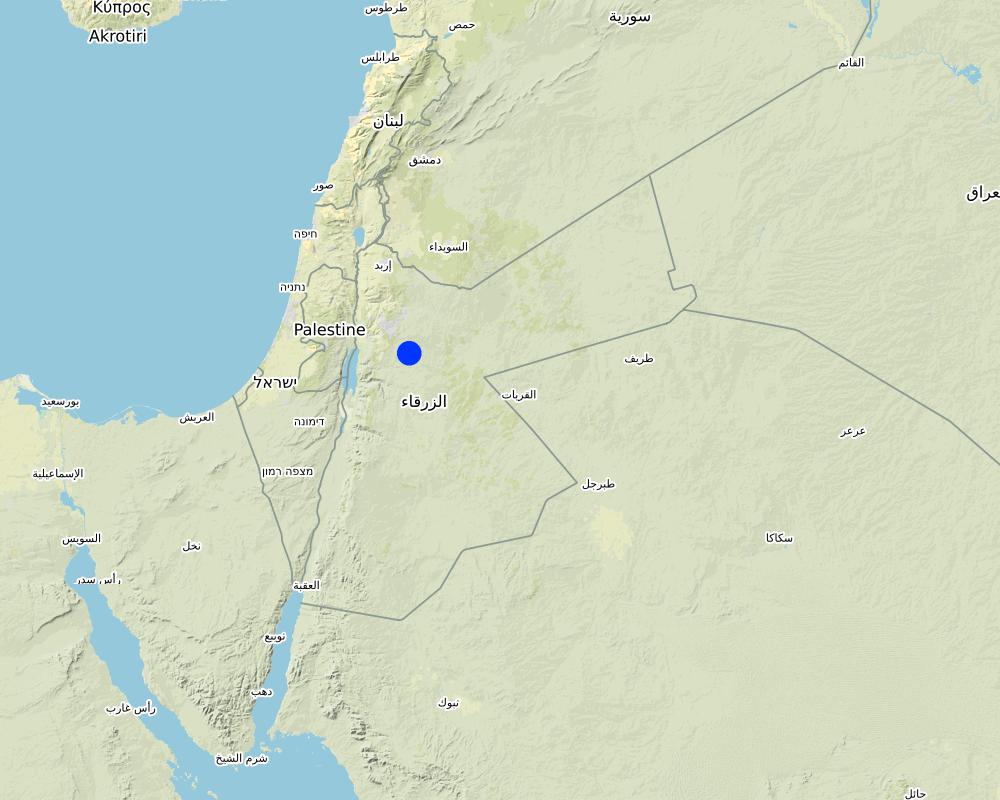
2: Where: This technology is used in a watershed context close to Al Majeddyeh village, located in the Middle Badia zone, approximately 30 km south-east of Amman. The climate is arid and warm (Palmer, 2013). The average annual rainfall is around 130 mm. The natural environment is classified as steppe, Bsh in the köppen classification. The human environment is characterized by agropastoralists. They are semi-nomadic and live in villages around the watershed, for example, Al Majeddyeh village.
3: The purpose of the technology: Breaking the land degradation cycle by retaining and encouraging deep-infiltration of surface runoff, which supports native vegetation growth. The stored soil moisture boosts the growth of both out-planted shrub seedlings and emerging local seeds towards healthy and resilient vegetation patches. Over time, the plowed pits degrade, but vegetation takes over the dryland hydrological functions of rainfall interception, runoff deceleration, and fostering infiltration. The developing shrubland provides various ecosystem services, predominately fodder for livestock of local agropastoralists.
4: Major activities: 1) Mechanized micro water harvesting establishment through the Vallerani tractor plow. 2) plantation of native seedlings in the pits (2 shrubs per pit at the local site). 3) Manage rangelands through sustainable grazing.
5: Impact: The technology breaks up the degradation cycle, increases soil moisture, and eventually boosts vegetation development and biodiversity. Through retention of runoff, sediments and residues, it decreases erosion and enhances organic carbon storage. It reduces peak surface runoff and thus mitigates flooding. The enhanced biomass supports livestock (grazing) and reduces agricultural inputs required (such as those required for low input barley production).
6: Land users' opinion: Land users evaluate the technology ambivalently. In the short term, landowners are often skeptical, because the rehabilitation requires a recovery time and strict non-grazing/resting for (usually) the first 2 rainy seasons. Thereafter, the rehabilitated lands require sustainable management. Later, after vegetation development, most landowners are convinced of the improvements and understand the economic and environmental value. The acceptance strongly depends on the social and cultural context – many farmers continue preferring the already established barley monoculture, mainly due to lack of sustainable rangeland management options and land ownership. However, well-targeted awareness campaigns can be supportive.
2.3 Photos de la Technologie
Galerie Médias

2.5 Pays/ région/ lieux où la Technologie a été appliquée et qui sont couverts par cette évaluation
Pays:
Jordanie
Région/ Etat/ Province:
Amman governorates /Al Jiza District/Al Majeddyeh Village
Autres spécifications du lieu:
Al Majeddyeh Village
Spécifiez la diffusion de la Technologie:
- répartie uniformément sur une zone
Si la Technologie est uniformément répartie sur une zone, précisez la superficie couverte (en km2):
30,0
Est-ce que les sites dans lesquels la Technologie est appliquée sont situés dans des zones protégées en permanence?
Non
Map
×2.6 Date de mise en œuvre de la Technologie
Indiquez l'année de mise en œuvre:
2016
2.7 Introduction de la Technologie
Spécifiez comment la Technologie a été introduite: :
- au cours d'expérimentations / de recherches
- par le biais de projets/ d'interventions extérieures
Commentaires (type de projet, etc.) :
This specific project was serving as a basis for SLM introduction and was launched in 2016.
The Vallerani Plough was locally tested in earlier projects.
The Vallerani Plough in Badia rehabilitation context was first introduced in Syria in 2004-2007.
3. Classification de la Technologie de GDT
3.1 Principal(aux) objectif(s) de la Technologie
- améliorer la production
- réduire, prévenir, restaurer les terres dégradées
- préserver l'écosystème
- protéger un bassin versant/ des zones situées en aval - en combinaison avec d'autres technologies
- s'adapter au changement et aux extrêmes climatiques et à leurs impacts
3.2 Type(s) actuel(s) d'utilisation des terres, là où la Technologie est appliquée
Les divers types d'utilisation des terres au sein du même unité de terrain: :
Non

Pâturages
Pâturage extensif:
- Pastoralisme de type semi-nomade
Pâturage intensif/ production fourragère :
- Prairies améliorées
- Grazing Management plan
Type d'animal:
- caprine
- ovins
Est-ce que la gestion intégrée cultures-élevage est pratiquée?
Oui
Si oui, veuillez préciser:
crop and livestock farming combined
- So far, the site opened for grazing after 2 years of protection in Oct.-Nov. 2018, Oct.- Nov. 2019, as well as April and Nov. 2020
Espèces:
caprine
Nombre:
300
Espèces:
ovins
Nombre:
50

Autre
Précisez:
Restoration
Remarques:
Planting of native shrub species: Atriplex Halimus, Retama, and Salsola.
3.3 Est-ce que l’utilisation des terres a changé en raison de la mise en œuvre de la Technologie ?
Est-ce que l’utilisation des terres a changé en raison de la mise en œuvre de la Technologie ?
- Non (Passez à la question 3.4)
3.4 Approvisionnement en eau
Approvisionnement en eau des terres sur lesquelles est appliquée la Technologie:
- pluvial
Commentaires:
The technology harvests surface runoff of erratic and heavy rainstorms
3.5 Groupe de GDT auquel appartient la Technologie
- Amélioration de la couverture végétale/ du sol
- mesures en travers de la pente
- récupération/ collecte de l'eau
3.6 Mesures de GDT constituant la Technologie

pratiques agronomiques
- A4: Traitement de la couche profonde du sol
- A6: Gestion des résidus des cultures

pratiques végétales
- V2: Herbes et plantes herbacées pérennes
- V5: Autres

structures physiques
- S2: Diguettes, digues
- S11: Autres

modes de gestion
- M2: Changement du niveau de gestion / d'intensification
- M3: Disposition/plan en fonction de l'environnement naturel et humain
- M4: Changement majeur dans le calendrier des activités
- M5: Contrôle/ changement de la composition des espèces
- M7: Autres
autres mesures
Précisez:
Specify tillage system: reduced tillage (> 30% soil cover)
Specify residue management: grazed
Comments/ remarks: Vegetation biomass is used as fodder for livestock as well as retained (for recruitment) – managed through a sustainable grazing plan. The technology consists of a combination of structural and re-vegetative measures. The structural measure provides the opportunity for vegetation development beyond the out-planted species.
Commentaires:
Native shrubs (fodder shrubs) planted in the water harvesting pits.
Intermittent pits constructed by the Vallerani Plough
Management (grazing) plan after implementation
3.7 Principaux types de dégradation des terres traités par la Technologie

érosion hydrique des sols
- Wt: perte de la couche superficielle des sols (couche arable)/ érosion de surface
- Wg: ravinement/ érosion en ravines
- Wo: effets hors-site de la dégradation

érosion éolienne des sols
- Et: perte de la couche superficielle des sols (couche arable)
- Ed: déflation et déposition
- Eo: effets hors site de la dégradation

dégradation chimique des sols
- Cn: baisse de la fertilité des sols et réduction du niveau de matière organique (non causée par l’érosion)

dégradation physique des sols
- Pc: compaction
- Pk: scellage et encroûtement

dégradation biologique
- Bc: réduction de la couverture végétale
- Bh: perte d’habitats
- Bs: baisse de la qualité et de la composition/ diversité des espèces
- Bl: perte de la vie des sols

dégradation hydrique
- Ha: aridification
- Hs: changement de la quantité d’eau de surface
Commentaires:
Degradation is mainly caused by over-exploitation of vegetation (overgrazing), mechanized agriculture (ploughing and barley seeding) – but accelerated by climate change.
3.8 Prévention, réduction de la dégradation ou réhabilitation des terres dégradées
Spécifiez l'objectif de la Technologie au regard de la dégradation des terres:
- réduire la dégradation des terres
- restaurer/ réhabiliter des terres sévèrement dégradées
4. Spécifications techniques, activités, intrants et coûts de mise en œuvre
4.1 Dessin technique de la Technologie
Spécifications techniques (associées au dessin technique):
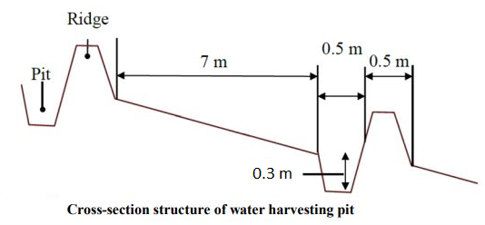
The dimensions of the water harvesting pits, constructed by the Vallerani tractor plow, are 4.5m, 0.5m, and 0.3m in length, width, and depth. With those dimensions, the effective water capturing total volume of one pit reaches approximately 0.2 to 0.3 m3 – depending on the formation process (e.g., depending on terrain, local soil, tractor speed). The interspace between the contours of water harvesting pits (in downslope direction) is approximately 7 meters at the implementation site. However, interspace strongly varies due to local terrain, soil, and rainfall pattern. The lateral spacing between pits is around 0.5m-1.0m.
Two local shrub seedlings of either Atriplex Halimus, Retama, or Salsola have been out-planted in the pit. These plants are native (adapted to the local environment) and drought tolerant. However, the early stage seedlings are vulnerable, and micro water harvesting substantially increases survival and fast development and allows the cumulation of top-soil, residues, and seed material.
At the specific site, micro water harvesting was established on slopes varying between 2% and 15%. The local rehabilitated area is around 10 hectares large. Around 1500 pits have been developed corresponding to 3000 planted shrub seedlings.
Auteur:
Sayo Fukai
Date:
01/11/2019
4.2 Informations générales sur le calcul des intrants et des coûts
Spécifiez la manière dont les coûts et les intrants ont été calculés:
- par superficie de la Technologie
Indiquez la taille et l'unité de surface:
1ha
Indiquez la monnaie utilisée pour le calcul des coûts:
- dollars américains
4.3 Activités de mise en place/ d'établissement
| Activité | Calendrier des activités (saisonnier) | |
|---|---|---|
| 1. | Site Selection (biophysical suitability) | At least 1 year prior implementation |
| 2. | Site inspection & local community consultation (social assessment, awareness and planning) | Around 1 year prior implementation |
| 3. | Ploughing of micro water harvesting pits along the contour (e.g. laser guided) | Late dry season (at least 1 month prior rainy season onset) |
| 4. | Out-planting of native shrubs seedlings (e.g. Atriplex and Ratameh) – potentially community inclusive activity | After first substantial rainfall (e.g. > 5mm rainfall event) |
| 5. | Sustainable management by the local community (grazing and resting plan) | Approximately after 2 years (sustainable grazing includes certain resting – chance for seeds production and recruitment) |
4.4 Coûts et intrants nécessaires à la mise en place
| Spécifiez les intrants | Unité | Quantité | Coûts par unité | Coût total par intrant | % du coût supporté par les exploitants des terres | |
|---|---|---|---|---|---|---|
| Main d'œuvre | Tractor plough operation | Labour Day per hectare | 0,2 | 25,0 | 5,0 | |
| Main d'œuvre | Technical assistance | LD | 0,2 | 50,0 | 10,0 | |
| Main d'œuvre | Seedling planters (local community) | LD | 5,0 | 20,0 | 100,0 | |
| Equipements | Tractor + Vallerani Plough (transport & fuel) | Day | 0,2 | 200,0 | 40,0 | |
| Equipements | Field equipment | Day | 1,0 | 20,0 | 20,0 | |
| Matériel végétal | Atriplex Halimus | Seedling | 100,0 | 0,5 | 50,0 | |
| Matériel végétal | Retama | Seedling | 100,0 | 0,5 | 50,0 | |
| Matériel végétal | Salsola | Seedling | 100,0 | 0,5 | 50,0 | |
| Autre | Transportation and storage (e.g. seedlings) | Lumpsum per hectare | 1,0 | 20,0 | 20,0 | |
| Coût total de mise en place de la Technologie | 345,0 | |||||
| Coût total de mise en place de la Technologie en dollars américains (USD) | 345,0 | |||||
Commentaires:
The shrub seedlings used were of high quality. A local community was used for labour. These two items increase costs per hectare – costs per hectare can be significantly reduced using ‘cheap’ seedlings or professional agricultural labour. However, the purpose of the project was local community inclusion and their benefit.
4.5 Activités d'entretien/ récurrentes
| Activité | Calendrier/ fréquence | |
|---|---|---|
| 1. | Sustainable grazing (take half / leave half concept) | 1-2 times per season |
| 2. | Cut and carry | locally |
| 3. | Resting for shrub-seed production and new recruitment | Some selected resting seasons |
4.6 Coûts et intrants nécessaires aux activités d'entretien/ récurrentes (par an)
Commentaires:
The technology aims at re-establishing a sustainable nature-based ecosystem. Once properly implemented and managed, no further maintenance is needed. Certainly, ‘costs’ during biomass facilitation accrue through, e.g., herding and watering of livestock; however, these costs are not considered to occur because of the landscape improvement.
4.7 Facteurs les plus importants affectant les coûts
Décrivez les facteurs les plus importants affectant les coûts :
The most important cost is the high-quality seedlings and the local labor costs. Both can be reduced.
5. Environnement naturel et humain
5.1 Climat
Précipitations annuelles
- < 250 mm
- 251-500 mm
- 501-750 mm
- 751-1000 mm
- 1001-1500 mm
- 1501-2000 mm
- 2001-3000 mm
- 3001-4000 mm
- > 4000 mm
Spécifiez la pluviométrie moyenne annuelle (si connue), en mm:
130,00
Spécifications/ commentaires sur les précipitations:
Jordan has a rainy season from September to May – but locally, the effective rainy season sets on later (November or December) and lasts until April.
The average annual rainfall on-site for the recent three years is approximately 130 mm.
Indiquez le nom de la station météorologique de référence considérée:
Queen Alia international airport reference station reports long term average annual rainfall of about 150 mm A rainfall tipping bucket installed in the site in 2016.
Zone agro-climatique
- aride
The maximum temperature usually occurred between July and August.
The average daily maximum temperature is 25.01 °C.
The average daily minimum temperature is 8.5 °C
5.2 Topographie
Pentes moyennes:
- plat (0-2 %)
- faible (3-5%)
- modéré (6-10%)
- onduleux (11-15%)
- vallonné (16-30%)
- raide (31-60%)
- très raide (>60%)
Reliefs:
- plateaux/ plaines
- crêtes
- flancs/ pentes de montagne
- flancs/ pentes de colline
- piémonts/ glacis (bas de pente)
- fonds de vallée/bas-fonds
Zones altitudinales:
- 0-100 m
- 101-500 m
- 501-1000 m
- 1001-1500 m
- 1501-2000 m
- 2001-2500 m
- 2501-3000 m
- 3001-4000 m
- > 4000 m
Indiquez si la Technologie est spécifiquement appliquée dans des:
- non pertinent
Commentaires et précisions supplémentaires sur la topographie:
Site topography ranges from 853 to 910 m above sea level (ASL), with an average slope steepness of 7.4 %.
5.3 Sols
Profondeur moyenne du sol:
- très superficiel (0-20 cm)
- superficiel (21-50 cm)
- modérément profond (51-80 cm)
- profond (81-120 cm)
- très profond (>120 cm)
Texture du sol (de la couche arable):
- moyen (limoneux)
Texture du sol (> 20 cm sous la surface):
- moyen (limoneux)
Matière organique de la couche arable:
- faible (<1%)
Si disponible, joignez une description complète du sol ou précisez les informations disponibles, par ex., type de sol, pH/ acidité du sol, capacité d'échange cationique, azote, salinité, etc.
The soil texture ranges from silty clay to silty clay loam.
Soil pH ranges from 8 – 8.5.
The soil is not saline.
5.4 Disponibilité et qualité de l'eau
Profondeur estimée de l’eau dans le sol:
> 50 m
Disponibilité de l’eau de surface:
faible/ absente
Qualité de l’eau (non traitée):
eau inutilisable
La qualité de l'eau fait référence à:
eaux souterraines
La salinité de l'eau est-elle un problème? :
Non
La zone est-elle inondée?
Oui
Régularité:
fréquemment
5.5 Biodiversité
Diversité des espèces:
- élevé
Diversité des habitats:
- élevé
Commentaires et précisions supplémentaires sur la biodiversité:
Atriplex, Ratameh and Salsola were actively out-planted (native species). This is not very biodiverse, but the evolving micro-habitat within the water harvesting pit allows emergence of collected seeds and consequential development of biodiverse vegetation patches
5.6 Caractéristiques des exploitants des terres appliquant la Technologie
Sédentaire ou nomade:
- Sédentaire
- Semi-nomade
Orientation du système de production:
- exploitation mixte (de subsistance/ commerciale)
Revenus hors exploitation:
- moins de 10% de tous les revenus
Niveau relatif de richesse:
- pauvre
- moyen
Individus ou groupes:
- individu/ ménage
Niveau de mécanisation:
- mécanisé/ motorisé
Genre:
- hommes
Age des exploitants des terres:
- jeunes
- personnes d'âge moyen
Indiquez toute autre caractéristique pertinente des exploitants des terres:
The actual landowners and users are often poor Jordanians. However, the owners of the large livestock flocks (potential facilitators of the rehabilitated lands) are comparatively rich.
5.7 Superficie moyenne des terres utilisées par les exploitants des terres appliquant la Technologie
- < 0,5 ha
- 0,5-1 ha
- 1-2 ha
- 2-5 ha
- 5-15 ha
- 15-50 ha
- 50-100 ha
- 100-500 ha
- 500-1 000 ha
- 1 000-10 000 ha
- > 10 000 ha
Cette superficie est-elle considérée comme de petite, moyenne ou grande dimension (en se référant au contexte local)?
- moyenne dimension
5.8 Propriété foncière, droits d’utilisation des terres et de l'eau
Propriété foncière:
- individu, avec titre de propriété
Droits d’utilisation des terres:
- individuel
- NA
Est-ce que les droits d'utilisation des terres sont fondés sur un système juridique traditionnel?
Oui
5.9 Accès aux services et aux infrastructures
santé:
- pauvre
- modéré
- bonne
éducation:
- pauvre
- modéré
- bonne
assistance technique:
- pauvre
- modéré
- bonne
emploi (par ex. hors exploitation):
- pauvre
- modéré
- bonne
marchés:
- pauvre
- modéré
- bonne
énergie:
- pauvre
- modéré
- bonne
routes et transports:
- pauvre
- modéré
- bonne
eau potable et assainissement:
- pauvre
- modéré
- bonne
services financiers:
- pauvre
- modéré
- bonne
6. Impacts et conclusions
6.1 Impacts sur site que la Technologie a montrés
Impacts socio-économiques
Production
production fourragère
qualité des fourrages
production animale
diversité des produits
gestion des terres
Revenus et coûts
dépenses pour les intrants agricoles
charge de travail
Impacts socioculturels
sécurité alimentaire/ autosuffisance
possibilités de loisirs
connaissances sur la GDT/ dégradation des terres
Impacts écologiques
Cycle de l'eau/ ruissellement
quantité d'eau
récolte/ collecte de l'eau
ruissellement de surface
évaporation
Sols
humidité du sol
couverture du sol
perte en sol
accumulation de sol
encroûtement/ battance du sol
matière organique du sol/ au dessous du sol C
Biodiversité: végétale, animale
Couverture végétale
biomasse/ au dessus du sol C
diversité végétale
espèces étrangères envahissantes
diversité des habitats
Réduction des risques de catastrophe et des risques climatiques
impacts des inondations
impacts des cyclones, pluies torrentielles
microclimat
6.2 Impacts hors site que la Technologie a montrés
flux des cours d'eau fiables et stables en saison sèche
inondations en aval
envasement en aval
sédiments (indésirables) transportés par le vent
6.3 Exposition et sensibilité de la Technologie aux changements progressifs et aux évènements extrêmes/catastrophes liés au climat (telles que perçues par les exploitants des terres)
Changements climatiques progressifs
Changements climatiques progressifs
| Saison | Augmentation ou diminution | Comment la Technologie fait-elle face à cela? | |
|---|---|---|---|
| températures annuelles | augmente | très bien | |
| précipitations annuelles | décroît | très bien |
Extrêmes climatiques (catastrophes)
Catastrophes météorologiques
| Comment la Technologie fait-elle face à cela? | |
|---|---|
| pluie torrentielle locale | très bien |
Catastrophes climatiques
| Comment la Technologie fait-elle face à cela? | |
|---|---|
| conditions hivernales extrêmes | très bien |
Catastrophes hydrologiques
| Comment la Technologie fait-elle face à cela? | |
|---|---|
| crue éclair | très bien |
6.4 Analyse coûts-bénéfices
Quels sont les bénéfices comparativement aux coûts de mise en place (du point de vue des exploitants des terres)?
Rentabilité à court terme:
légèrement négative
Rentabilité à long terme:
positive
Quels sont les bénéfices comparativement aux coûts d'entretien récurrents (du point de vue des exploitants des terres)?
Rentabilité à court terme:
très positive
Rentabilité à long terme:
très positive
6.5 Adoption de la Technologie
- 1-10%
De tous ceux qui ont adopté la Technologie, combien d'entre eux l'ont fait spontanément, à savoir sans recevoir aucune incitation matérielle, ou aucune rémunération? :
- 11-50%
6.6 Adaptation
La Technologie a-t-elle été récemment modifiée pour s'adapter à l'évolution des conditions?
Oui
autre (précisez):
watershed approach and transition status of the structures
Spécifiez l'adaptation de la Technologie (conception, matériaux/ espèces, etc.):
Implementation efficiency increase through adding contour laser technique and using the reversible blade (2 directions plowing)
6.7 Points forts/ avantages/ possibilités de la Technologie
| Points forts/ avantages/ possibilités du point de vue de l'exploitant des terres |
|---|
| Opportunity for agro-pastoralism (grazing up to twice a year) |
| Improved livestock health, milk quantity, and quality. |
| No input costs needed (compared with e.g. barley agriculture) |
| Flexibility in timing: grazing of healthy rangelands can be done ‘at any time’(certainly spring season is most beneficial for livestock) – which differs from barley agriculture approach. |
| Points forts/ avantages/ possibilités du point de vue du compilateur ou d'une autre personne ressource clé |
|---|
| Besides out-planting of native shrub seedlings, native biodiversity evolves through the emergence of dormant seed material. |
| Out-planted shrub seedlings withstand extreme weather conditions (droughts) through water harvesting. The survival rate and eventual success of the rehabilitation approach are high. |
| Micro water harvesting structures and upcoming vegetation patches reduce erosion and increase trapping of sediments, including organic carbon and seed materials. |
| Water harvesting reduces the peak of surface runoff and thus mitigates downstream flooding |
6.8 Faiblesses/ inconvénients/ risques de la Technologie et moyens de les surmonter
| Faiblesses/ inconvénients/ risques du point de vue de l’exploitant des terres | Comment peuvent-ils être surmontés? |
|---|---|
| Costs of implementation and availability of high-quality seedlings and the Vallerani plow. | Develop large-scale procedure/initiative that allows farmers to request and restore vulnerable areas using the Vallerani micro-water harvesting technique. Include incentives for implementation (ex. free seedlings, free of charge using of Vallerani machine, subsidies on arley as fodder for the first two years in order for farmers to maintain the site) |
| Change: Not all farmers are willing to forgo barley agriculture | Demonstrating the effects this technology through pilot projects. Local communities on the forefront of communication. |
| Vegetation growth may attract herders from different areas. | Clear rules and legislation on land facilitation in terms of grazing. |
| Requires higher understanding of the environment and long-term planning | Introduce knowledge sharing events to teach local farmers on the effects of land degradation and the benefits of healthy ecosystems |
| Faiblesses/ inconvénients/ risques du point de vue du compilateur ou d'une autre personne ressource clé | Comment peuvent-ils être surmontés? |
|---|---|
| Land ownership: current land tenure system in Jordan slows the adoption of the intervention. A landowner can reside in a city (no much value for the land), and the land user may be a herder. A large flock owner can rent huge areas for barley cultivation (actual cost of 1 donum of barley plantation ranges between 1.5-3 USD; possible to prepare up to 10 ha per day). Cheap labor/herders will move flocks and graze until all cover is gone (usually for 1-3 months maximum per year (March-May)). Rehabilitated areas will be of less interest for such users. | Develop and apply strict land management plans and policies. Create a strong monitoring system. Apply penalties for actions that increase land degradation with various on-site and off-sites impacts |
| Lack of institutional collaboration for rangeland management and rehabilitation. Land management in the Badia is the responsibility of several ministries in Jordan. The lack of institutional collaboration and the absence of the rangeland areas' valuation create a difficult environment for sustainability measures. | Increase the collaboration between ministries and stakeholders. Evaluate the impact of restoration solutions on the site and off site. |
| Lack of clear government policy for restoration, incentives for farmers, and funding availability. | Develop a clear action plan among the responsible government institutions of restoration activities. |
| Complex social context. The majority of land users and/or landowners don’t value the restoration. The bare cultivation practices have more (quick) value without resting time. | Capacity development for local communities for the value of soil, water, and biodiversity |
7. Références et liens
7.1 Méthodes/ sources d'information
- visites de terrain, enquêtes sur le terrain
15
- interviews/entretiens avec les exploitants des terres
2
- interviews/ entretiens avec les spécialistes/ experts de GDT
4
- compilation à partir de rapports et d'autres documents existants
Quand les données ont-elles été compilées (sur le terrain)?
15/02/2020
7.2 Références des publications disponibles
Titre, auteur, année, ISBN:
Akroush, S., & All, E. (2016). Factors Affecting the Adoption of Water Harvesting Technologies: A Case Study of Jordanian Arid Area. Sustainable Agriculture Research.
Titre, auteur, année, ISBN:
Akroush, S., & Boubaker, D. (2015). Predicted Willingness of Farmers to Adopt Water Harvesting Technologies: A Case Study from the Jordanian Badia (Jordan). American-Eurasian J. Agricultural & Environmental science , 1502-1513.
Titre, auteur, année, ISBN:
Gammoh, & Oweis. (2011). Performance and Adaptation of the Vallerani Mechanized Water Harvesting System in Degraded Badia Rangelands . Journal of Environmental Science and Engineering, 1370-1380.
Titre, auteur, année, ISBN:
Haddad, M. (2019). Exploring Jordan's Rangeland Transition: Merging Restoration Eperiment with Modeling - A Case study from Al Majdiyya Village. Amman: The University of Jordan.
Titre, auteur, année, ISBN:
Vallerani. (n.d.). Vallerani system. Retrieved from Vallerani: http://www.vallerani.com/wp/
7.3 Liens vers les informations pertinentes en ligne
Titre/ description:
VALLERANI MICRO WATER HARVESTING
URL:
https://www.icarda.org/impact/impact-stories/vallerani-micro-water-harvesting
Titre/ description:
CONTOUR LASER GUIDING FOR THE MECHANIZED “VALLERANI” MICRO-CATCHMENT WATER HARVESTING SYSTEMS
URL:
https://www.icarda.org/publications/10291/contour-laser-guiding-mechanized-vallerani-micro-catchment-water-harvesting
7.4 Observations d'ordre général
The Marab is a local downstream water harvesting measure in an integrated watershed context, where up/midstream users and applied land management practices affect the Marab.
The technology diverts and spreads excess runoff over deep-soil flood plains. The technology comprises local gully-filling, grading/leveling of seedbed, and construction of a bund-and-spillway system creating several compartments for flood-irrigated agriculture.
For more information please visit: https://qcat.wocat.net/en/wocat/technologies/view/technologies_5770/
Liens et modules
Développer tout Réduire toutLiens
Aucun lien
Modules
Aucun module trouvé