Building Walls's stones to protect lands and building outlet to drain excess water [Yémen]
- Création :
- Mise à jour :
- Compilateur : ahmed algalal
- Rédacteur : –
- Examinateur : David Streiff
الجدران الحجرية والمفيضات
technologies_1578 - Yémen
- Résumé complet en PDF
- Résumé complet en PDF pour impression
- Résumé complet dans le navigateur
- Résumé complet (non formaté)
- Building Walls's stones to protect lands and building outlet to drain excess water: 24 juin 2017 (inactive)
- Building Walls's stones to protect lands and building outlet to drain excess water: 11 août 2019 (inactive)
- Building Walls's stones to protect lands and building outlet to drain excess water: 4 avril 2024 (public)
Voir les sections
Développer tout Réduire tout1. Informations générales
1.2 Coordonnées des personnes-ressources et des institutions impliquées dans l'évaluation et la documentation de la Technologie
Spécialiste GDT:
Sallam Ahmed
sallam28@yahoo.com
Agricultural Research and Extension Authority
Yémen
Spécialiste GDT:
Alhadrami Yahya
00967777249274
General Directorate for irrigation
Sanaa
Yémen
Nom du ou des institutions qui ont facilité la documentation/ l'évaluation de la Technologie (si pertinent)
General Directorate of Irrigation - YémenNom du ou des institutions qui ont facilité la documentation/ l'évaluation de la Technologie (si pertinent)
Agricultural Research and Extension Authority (AREA) - Yémen1.3 Conditions relatives à l'utilisation par WOCAT des données documentées
Quand les données ont-elles été compilées (sur le terrain)?
13/02/2013
Le compilateur et la(les) personne(s) ressource(s) acceptent les conditions relatives à l'utilisation par WOCAT des données documentées:
Oui
2. Description de la Technologie de GDT
2.1 Courte description de la Technologie
Définition de la Technologie:
use the stones to build walls around agricultural terraces to protect them from erosion and make outlets (Spillway) to discharge excess water and prevent the destruction of the stands
2.2 Description détaillée de la Technologie
Description:
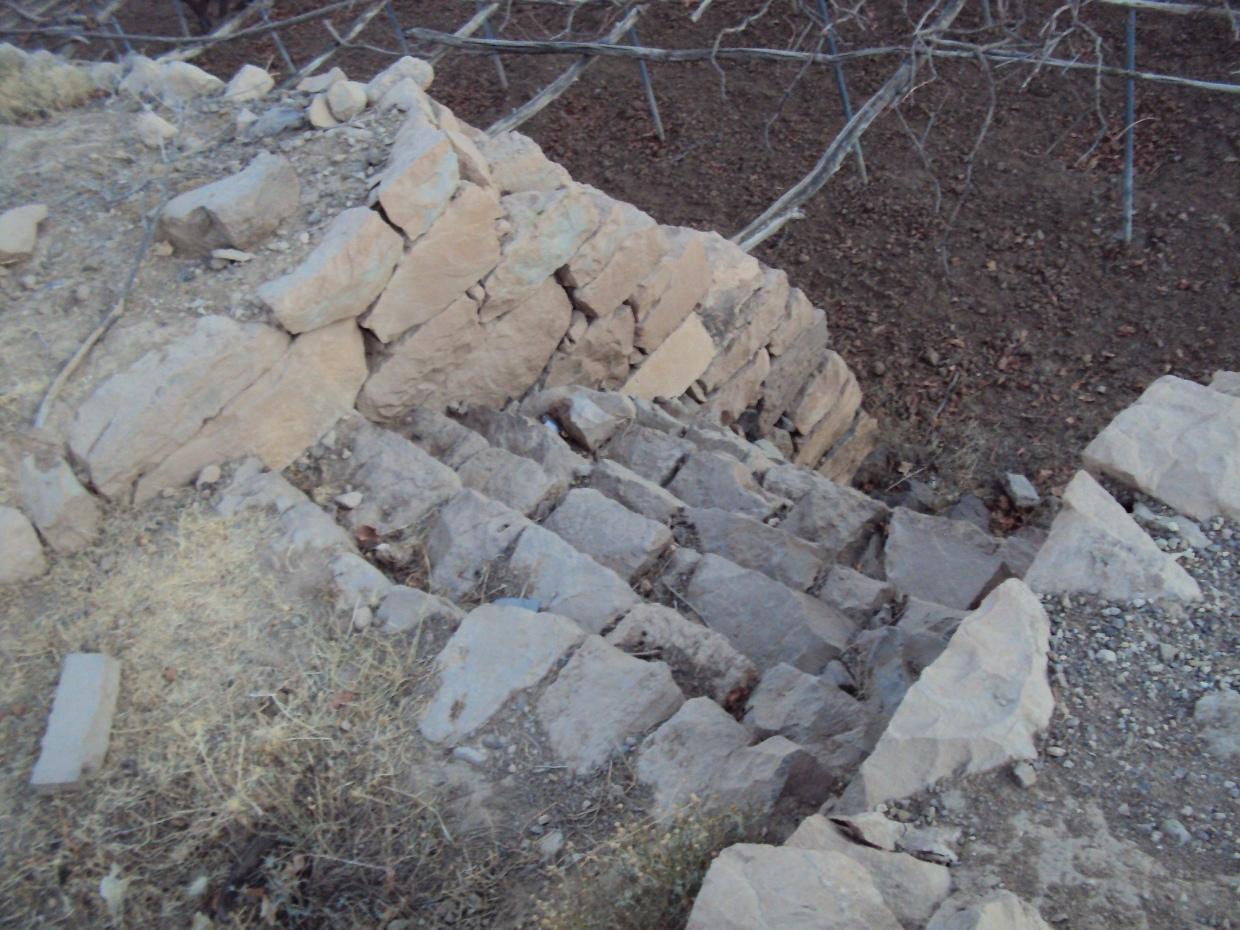
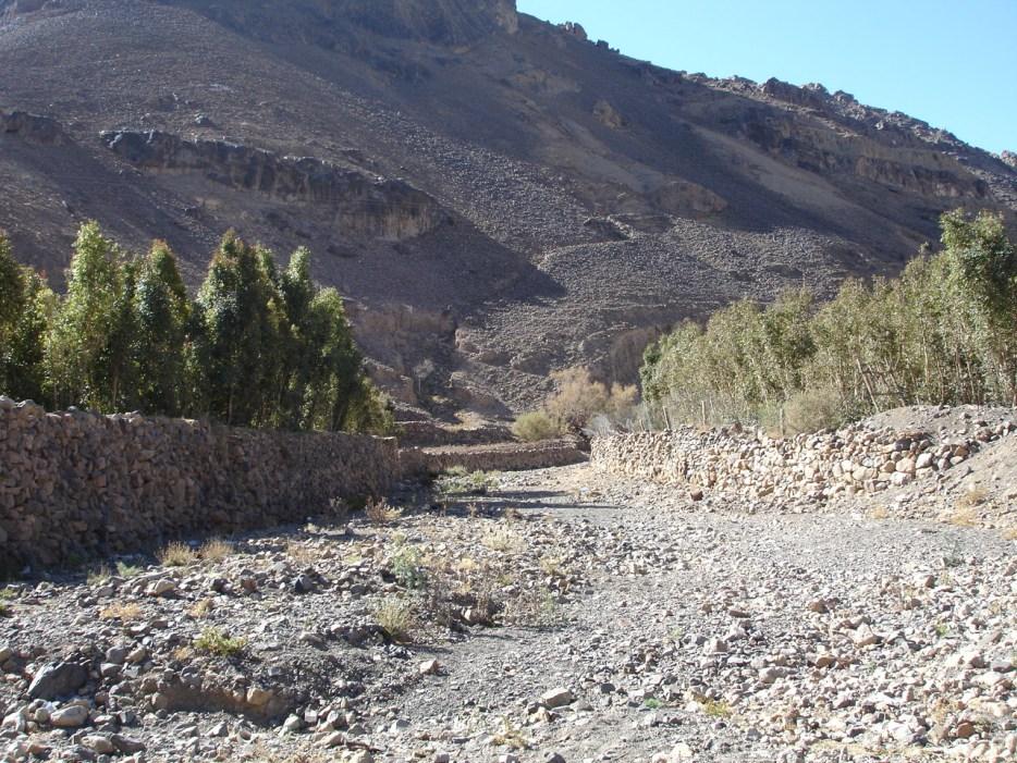
Is a structural one of the types of measures and that is where build walls around the land of stones available in the area to protect agricultural terraces from erosion as a result of the speed of the water flow.
This process starts of building walls to collect stones available and building walls around the agricultural terraces, which is beside the waterway and then land agricultural away from the stream where are building walls around land terraces threatened drift ranges wall height 2-3 meters and a width of 30 cm and is accompanied by building outlets with the construction of the walls. Different view slot spillway and the number depending on the amount of water entering the agricultural land terraces which is used irrigation number of agricultural terraces about 4 - 5 terraces (pieces) where irrigation start from the top-down system of first come through outlets which works to protect the land from erosion and destruction by water pressure due process flood irrigation .
walls and outlets Were built by hands where the process of building need a long time, the walls are built gradually according to the height of the surface of the soil where you are collecting sediment , which requires him to do to raise the walls and well outlets .
The implementation of this technique in filled valleys on the slope moderate 5% of the irrigation system mixed and used to irrigate crop of grapes , mainly for the purpose of self-sufficiency and to go to the market to trade, is the technology of long-term investments that need to be high costs in the process of starch and because of the natural conditions of flow velocity and the output from a pool of water in the mountain slopes , the process of maintenance necessary to sustain and maintain the technology .
2.3 Photos de la Technologie
Galerie Médias
2.5 Pays/ région/ lieux où la Technologie a été appliquée et qui sont couverts par cette évaluation
Pays:
Yémen
Région/ Etat/ Province:
Sana
Autres spécifications du lieu:
Bani Hushaish district
Map
×2.6 Date de mise en œuvre de la Technologie
Si l'année précise est inconnue, indiquez la date approximative: :
- il y a plus de 50 ans (technologie traditionnelle)
2.7 Introduction de la Technologie
Spécifiez comment la Technologie a été introduite: :
- dans le cadre d'un système traditionnel (> 50 ans)
Commentaires (type de projet, etc.) :
It is a very old technology but was rehabilitated in 1956 by the community
3. Classification de la Technologie de GDT
3.1 Principal(aux) objectif(s) de la Technologie
- réduire, prévenir, restaurer les terres dégradées
3.2 Type(s) actuel(s) d'utilisation des terres, là où la Technologie est appliquée

Terres cultivées
- Plantations d’arbres ou de buissons
Principales cultures (vivrières et commerciales):
major cash crop: Grapes and Qat
Commentaires:
Major land use problems (compiler’s opinion): Erosion of riparian valley resulting from the floods in addition to gully erosion on agricultural land
Major land use problems (land users’ perception): Erosion of agricultural terraces
3.3 Informations complémentaires sur l'utilisation des terres
Approvisionnement en eau des terres sur lesquelles est appliquée la Technologie:
- pluvial
Commentaires:
Water supply: Also mixed rainfed - irrigated and post-flooding
Nombre de période de croissance par an: :
- 1
Précisez:
Longest growing period in days: 90
3.4 Groupe de GDT auquel appartient la Technologie
- mesures en travers de la pente
- gestion de l'irrigation (incl. l'approvisionnement en eau, le drainage)
3.5 Diffusion de la Technologie
Spécifiez la diffusion de la Technologie:
- répartie uniformément sur une zone
Si la Technologie est uniformément répartie sur une zone, indiquez la superficie couverte approximative:
- 10-100 km2
Commentaires:
Total area covered by the SLM Technology is 20.6 km2.
Alrawanah Bani Hushaish, which is located on the eastern side of the capital Sanaa, and is about 16 km away
3.6 Mesures de GDT constituant la Technologie

structures physiques
- S1: Terrasses
3.7 Principaux types de dégradation des terres traités par la Technologie

érosion hydrique des sols
- Wg: ravinement/ érosion en ravines
- Wr: érosion des berges

dégradation physique des sols
- Ps: affaissement des sols organiques, tassement des sols
Commentaires:
Secondary types of degradation addressed: Ps: subsidence of organic soils, settling of soil
Main causes of degradation: floods (As a result of flow velocity and rainwater collected from many places)
Secondary causes of degradation: over-exploitation of vegetation for domestic use (For domestic use due to lack of alternatives such as gas), poverty / wealth (poverty), education, access to knowledge and support services
3.8 Prévention, réduction de la dégradation ou réhabilitation des terres dégradées
Spécifiez l'objectif de la Technologie au regard de la dégradation des terres:
- réduire la dégradation des terres
- restaurer/ réhabiliter des terres sévèrement dégradées
Commentaires:
Secondary goals: mitigation / reduction of land degradation
4. Spécifications techniques, activités, intrants et coûts de mise en œuvre
4.1 Dessin technique de la Technologie
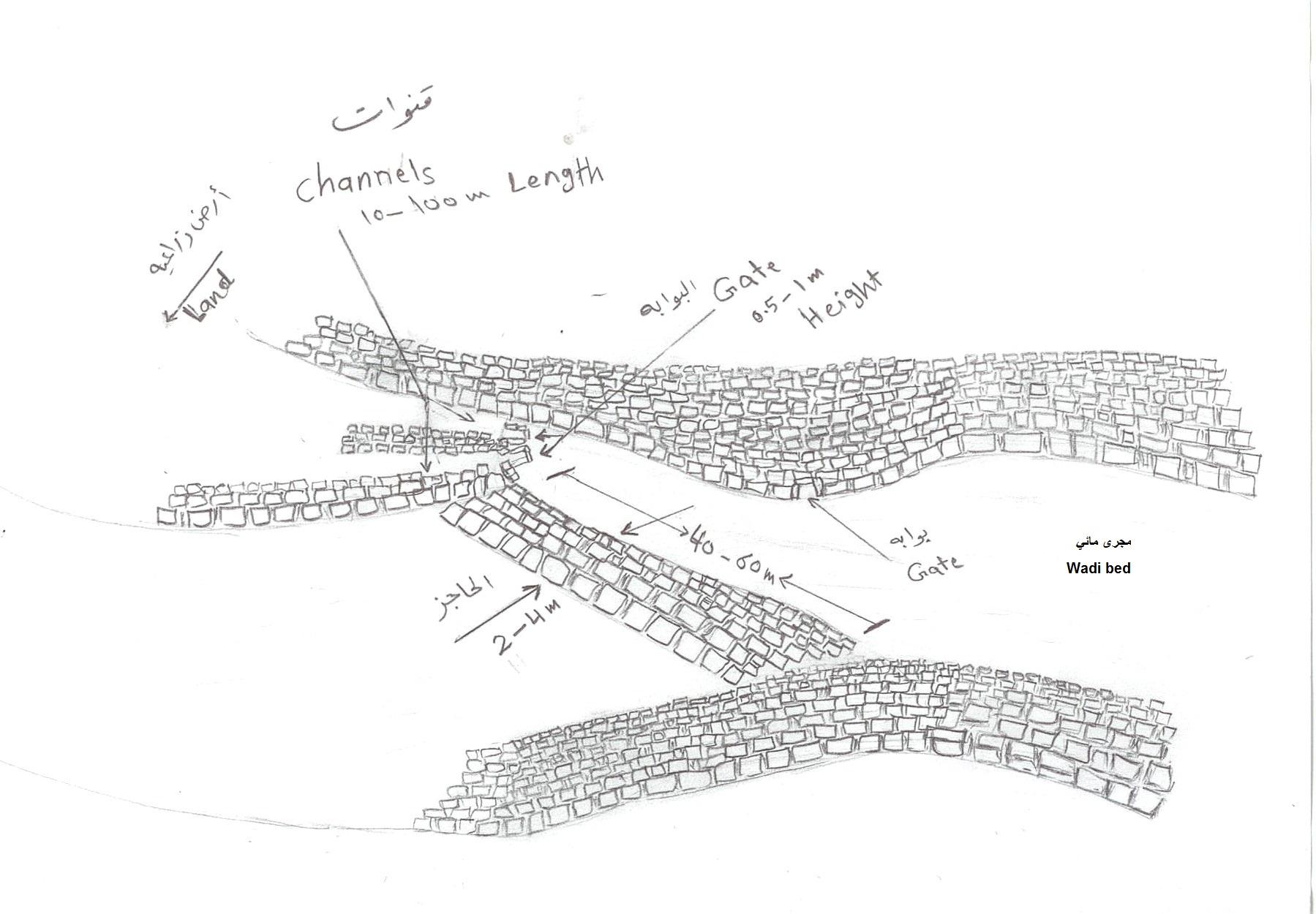
4.2 Spécification/ explications techniques du dessin technique
Stone walls with outlets
Location: Bani Hushaish district. Sana'a
Date: 15-3-2013
Technical knowledge required for field staff / advisors: high (The construction process requires skills and experiences)
Technical knowledge required for land users: low (Has enough experience)
Main technical functions: control of concentrated runoff: retain / trap, water spreading, Reduce runoff
Secondary technical functions: increase of groundwater level / recharge of groundwater, water harvesting / increase water supply, sediment retention / trapping, sediment harvesting
Spillway
Vertical interval between structures (m): S
Height of bunds/banks/others (m): 2 - 3
Width of bunds/banks/others (m): 1– 1.5
Structural measure: Stone walls
Vertical interval between structures (m): S
Height of bunds/banks/others (m): 2 - 3
Width of bunds/banks/others (m): 0.3
Length of bunds/banks/others (m): 60-100
Construction material (stone): Available stones in the region
Slope (which determines the spacing indicated above): 5%
For water harvesting: the ratio between the area where the harvested water is applied and the total area from which water is collected is: 1:1
4.3 Informations générales sur le calcul des intrants et des coûts
Indiquez la monnaie utilisée pour le calcul des coûts:
- dollars US
Indiquez le coût salarial moyen de la main d'œuvre par jour:
7.00
4.4 Activités de mise en place/ d'établissement
| Activité | Type de mesures | Calendrier | |
|---|---|---|---|
| 1. | Collecting stones | Structurel | Before the rainy season |
| 2. | Building outlets walls | Structurel | Before the rainy season |
| 3. | Packing the soil behind walls and outlets | Structurel | Before the rainy season |
| 4. | Settlement of the Earth's surface and filling the grooves | Structurel | Before the rainy season |
4.5 Coûts et intrants nécessaires à la mise en place
| Spécifiez les intrants | Unité | Quantité | Coûts par unité | Coût total par intrant | % du coût supporté par les exploitants des terres | |
|---|---|---|---|---|---|---|
| Main d'œuvre | Collecting stones | persons/day/ha | 150,0 | 7,0 | 1050,0 | 100,0 |
| Main d'œuvre | Building outlets walls | persons/day/ha | 500,0 | 7,0 | 3500,0 | 100,0 |
| Main d'œuvre | Packing the soil behind walls and outlets | persons/day/ha | 10,0 | 7,0 | 70,0 | 100,0 |
| Main d'œuvre | Settlement of the Earth's surface and filling the grooves | persons/day/ha | 10,0 | 7,0 | 70,0 | 100,0 |
| Equipements | Collecting stones (animal traction) | ha | 1,0 | 69,76 | 69,76 | 100,0 |
| Equipements | Tools | ha | 1,0 | 14,0 | 14,0 | 100,0 |
| Equipements | Settlement of the Earth's surface and filling the grooves (animal traction) | ha | 1,0 | 23,25 | 23,25 | 100,0 |
| Coût total de mise en place de la Technologie | 4797,01 | |||||
Commentaires:
Duration of establishment phase: 12 month(s)
4.6 Activités d'entretien/ récurrentes
| Activité | Type de mesures | Calendrier/ fréquence | |
|---|---|---|---|
| 1. | Repair walls and outlets | Structurel | annually after the rainy season |
4.7 Coûts et intrants nécessaires aux activités d'entretien/ récurrentes (par an)
| Spécifiez les intrants | Unité | Quantité | Coûts par unité | Coût total par intrant | % du coût supporté par les exploitants des terres | |
|---|---|---|---|---|---|---|
| Main d'œuvre | Repair walls and outlets | persons/day/ha | 20,0 | 7,0 | 140,0 | 100,0 |
| Coût total d'entretien de la Technologie | 140,0 | |||||
Commentaires:
Machinery/ tools: A Leveler , shovel and a big hammer
The calculated costs are based on the current situation and a length of the wall of 500 meters and a height of 2 meters and a width of 0.3 meters.
It should be noted that the walls do not work in all agricultural terraces, but they are working in areas threatened by drift but for outlets it is built in each of agricultural land terraces. Construction costs were calculated for walls with outlets including the number of working days per person. In fact most of the activities are at the same time and with the participation of a large number of people.
4.8 Facteurs les plus importants affectant les coûts
Décrivez les facteurs les plus importants affectant les coûts :
The most determinate factors affecting the costs are the collection and the transport of stones, and the difficulty of the road
5. Environnement naturel et humain
5.1 Climat
Précipitations annuelles
- < 250 mm
- 251-500 mm
- 501-750 mm
- 751-1000 mm
- 1001-1500 mm
- 1501-2000 mm
- 2001-3000 mm
- 3001-4000 mm
- > 4000 mm
Zone agro-climatique
- semi-aride
Thermal climate class: temperate
5.2 Topographie
Pentes moyennes:
- plat (0-2 %)
- faible (3-5%)
- modéré (6-10%)
- onduleux (11-15%)
- vallonné (16-30%)
- raide (31-60%)
- très raide (>60%)
Reliefs:
- plateaux/ plaines
- crêtes
- flancs/ pentes de montagne
- flancs/ pentes de colline
- piémonts/ glacis (bas de pente)
- fonds de vallée/bas-fonds
Zones altitudinales:
- 0-100 m
- 101-500 m
- 501-1000 m
- 1001-1500 m
- 1501-2000 m
- 2001-2500 m
- 2501-3000 m
- 3001-4000 m
- > 4000 m
Commentaires et précisions supplémentaires sur la topographie:
Altitudinal zone: 2400 m a.s.l.
5.3 Sols
Profondeur moyenne du sol:
- très superficiel (0-20 cm)
- superficiel (21-50 cm)
- modérément profond (51-80 cm)
- profond (81-120 cm)
- très profond (>120 cm)
Texture du sol (de la couche arable):
- moyen (limoneux)
- fin/ lourd (argile)
Matière organique de la couche arable:
- moyen (1-3%)
Si disponible, joignez une description complète du sol ou précisez les informations disponibles, par ex., type de sol, pH/ acidité du sol, capacité d'échange cationique, azote, salinité, etc.
Soil depth on average: 150 cm
Soil texture: Flood deposits
Topsoil organic matter: After falling grape leaves and weeds developing
Soil fertility is low - medium (output of the flood deposits)
Soil drainage / infiltration is medium - good
Soil water storage capacity is medium - high
5.4 Disponibilité et qualité de l'eau
Profondeur estimée de l’eau dans le sol:
> 50 m
Disponibilité de l’eau de surface:
faible/ absente
Qualité de l’eau (non traitée):
faiblement potable (traitement nécessaire)
Commentaires et précisions supplémentaires sur la qualité et la quantité d'eau:
Ground water table: 400 m
5.5 Biodiversité
Diversité des espèces:
- faible
5.6 Caractéristiques des exploitants des terres appliquant la Technologie
Orientation du système de production:
- mixte (de subsistance/ commercial)
Revenus hors exploitation:
- 10-50% de tous les revenus
Niveau relatif de richesse:
- pauvre
- moyen
Individus ou groupes:
- groupe/ communauté
Niveau de mécanisation:
- travail manuel
- traction animale
Genre:
- hommes
Indiquez toute autre caractéristique pertinente des exploitants des terres:
Land users applying the Technology are mainly common / average land users
Difference in the involvement of women and men: Women could not do the hard work, therefore, men do work on the farm and women do the house works.
Population density: > 500 persons/km2
Annual population growth: 3% - 4%
70% of the land users are average wealthy and own 90% of the land.
30% of the land users are poor and own 10% of the land.
100% of the land users are poor and own 100% of the land.
Level of mechanization: Also mechanized, but less common
5.7 Superficie moyenne des terres détenues ou louées par les exploitants appliquant la Technologie
- < 0,5 ha
- 0,5-1 ha
- 1-2 ha
- 2-5 ha
- 5-15 ha
- 15-50 ha
- 50-100 ha
- 100-500 ha
- 500-1 000 ha
- 1 000-10 000 ha
- > 10 000 ha
Cette superficie est-elle considérée comme de petite, moyenne ou grande dimension (en se référant au contexte local)?
- moyenne dimension
Commentaires:
0.45 – 0.9 fragmentation of tenure is the cause of the small ownership per household
5.8 Propriété foncière, droits d’utilisation des terres et de l'eau
Propriété foncière:
- individu, avec titre de propriété
Droits d’utilisation des terres:
- loué
- individuel
- Waqf
Droits d’utilisation de l’eau:
- communautaire (organisé)
- Waqf
Commentaires:
There are three types of land ownership owned, Waqf, and a share at 70%, 20%, 10% respectively.
5.9 Accès aux services et aux infrastructures
santé:
- pauvre
- modéré
- bonne
éducation:
- pauvre
- modéré
- bonne
assistance technique:
- pauvre
- modéré
- bonne
emploi (par ex. hors exploitation):
- pauvre
- modéré
- bonne
marchés:
- pauvre
- modéré
- bonne
énergie:
- pauvre
- modéré
- bonne
routes et transports:
- pauvre
- modéré
- bonne
eau potable et assainissement:
- pauvre
- modéré
- bonne
services financiers:
- pauvre
- modéré
- bonne
6. Impacts et conclusions
6.1 Impacts sur site que la Technologie a montrés
Impacts socio-économiques
Production
production agricole
risque d'échec de la production
surface de production
gestion des terres
Disponibilité et qualité de l'eau
demande pour l'eau d'irrigation
Revenus et coûts
revenus agricoles
diversité des sources de revenus
charge de travail
Impacts socioculturels
sécurité alimentaire/ autosuffisance
connaissances sur la GDT/ dégradation des terres
livelihood and human well-being
Commentaires/ spécifiez:
As a result of reduced labor and increased production, standard of living is improved and children can go to school.
Impacts écologiques
Cycle de l'eau/ ruissellement
ruissellement de surface
drainage de l'excès d'eau
nappes phréatiques/ aquifères
Sols
humidité du sol
perte en sol
Biodiversité: végétale, animale
diversité des habitats
Réduction des risques de catastrophe et des risques climatiques
impacts des inondations
6.2 Impacts hors site que la Technologie a montrés
envasement en aval
6.3 Exposition et sensibilité de la Technologie aux changements progressifs et aux évènements extrêmes/catastrophes liés au climat (telles que perçues par les exploitants des terres)
Changements climatiques progressifs
Changements climatiques progressifs
| Saison | Type de changements/ extrêmes climatiques | Comment la Technologie fait-elle face à cela? | |
|---|---|---|---|
| températures annuelles | augmente | bien |
Extrêmes climatiques (catastrophes)
Catastrophes météorologiques
| Comment la Technologie fait-elle face à cela? | |
|---|---|
| pluie torrentielle locale | bien |
Catastrophes hydrologiques
| Comment la Technologie fait-elle face à cela? | |
|---|---|
| inondation générale (rivière) | pas bien |
6.4 Analyse coûts-bénéfices
Quels sont les bénéfices comparativement aux coûts de mise en place (du point de vue des exploitants des terres)?
Rentabilité à court terme:
neutre / équilibrée
Rentabilité à long terme:
positive
Quels sont les bénéfices comparativement aux coûts d'entretien récurrents (du point de vue des exploitants des terres)?
Rentabilité à court terme:
positive
Rentabilité à long terme:
très positive
6.5 Adoption de la Technologie
Si disponible, quantifiez (nombre de ménages et/ou superficie couverte):
537 households covering 100 percent of the stated area
Commentaires:
537 land user families have adopted the Technology without any external material support
There is a moderate trend towards spontaneous adoption of the Technology
Comments on adoption trend: The technology is implemented at the level of the entire region, but due to a lack of capital the adoption is hindered.
6.7 Points forts/ avantages/ possibilités de la Technologie
| Points forts/ avantages/ possibilités du point de vue du compilateur ou d'une autre personne ressource clé |
|---|
|
Protection of the land from erosion How can they be sustained / enhanced? Continue the process of maintenance to maintain walls and outlets |
|
Increase in soil moisture How can they be sustained / enhanced? Maintenance of the outlets to ensure that they are working |
6.8 Faiblesses/ inconvénients/ risques de la Technologie et moyens de les surmonter
| Faiblesses/ inconvénients/ risques du point de vue du compilateur ou d'une autre personne ressource clé | Comment peuvent-ils être surmontés? |
|---|---|
| The inability of the walls to withstand severe flooding due to the use of only stones in construction | The use of stone and cement materials in the construction of walls |
7. Références et liens
7.2 Références des publications disponibles
Titre, auteur, année, ISBN:
Report of traditional knowledge and customs (sallam, et al, 2008)- General Census of Population, Housing and Establishment (Census, 2004). - 45. Guide of agricultural climate in Yemen (Al Khorasani, 2005).
Disponible à partir d'où? Coût?
Agricultural Research and ExtensionAuthority, AREACentral Bureau of StatisticsAgricultural Research and ExtensionAuthority, AREA
Liens et modules
Développer tout Réduire toutLiens
Aucun lien
Modules
Aucun module trouvé