
Terracing in Watershed [Afghanistan]
- Création :
- Mise à jour :
- Compilateur : Aqila Haidery
- Rédacteur : –
- Examinateur : David Streiff
Kordak dar Abriza
technologies_1732 - Afghanistan
Voir les sections
Développer tout Réduire tout1. Informations générales
1.2 Coordonnées des personnes-ressources et des institutions impliquées dans l'évaluation et la documentation de la Technologie
Spécialiste GDT:
Spécialiste GDT:
Fuleki Blanka
Helvetas
Nom du ou des institutions qui ont facilité la documentation/ l'évaluation de la Technologie (si pertinent)
HELVETAS (Swiss Intercooperation)1.3 Conditions relatives à l'utilisation par WOCAT des données documentées
Quand les données ont-elles été compilées (sur le terrain)?
19/04/2016
Le compilateur et la(les) personne(s) ressource(s) acceptent les conditions relatives à l'utilisation par WOCAT des données documentées:
Oui
1.5 Référence au(x) questionnaire(s) sur les Approches de GDT
Resilient Watershed Management Plan [Tadjikistan]
The participatory watershed management plan (WMP) is an interdisciplinary approach at community level to raise awareness on the watershed management concept and improve understanding of the watershed approach in planning and management of natural resource.
- Compilateur : Askarsho Zevarshoev
2. Description de la Technologie de GDT
2.1 Courte description de la Technologie
Définition de la Technologie:
Reshaping unproductive land into a series of levelled, gently-sloping platforms creates conditions suitable for cultivation and prevents accelerated erosion.
2.2 Description détaillée de la Technologie
Description:
The terracing in watershed fact-sheet is documented by Sustainable Land Management Project/HELVETAS Swiss Intercooperation which is funded by Swiss Agency for Development and Cooperation (SDC).
Due to the enduring conflict and to the breakdown of common-pool resources management in upper catchments areas over the past decades, most pastures in Afghanistan are degraded.
Uncontrolled grazing of animals tilling grazing land to grow cereal crops are the main contributors to the loss of vegetation coverage in the upper catchments. One of the negative consequences is repeated flash floods each year causing loss and damage of agriculture lands, gardens, road, canal, infrastructure, houses and even lives. To decrease the severity of flash floods and extend vegetation in upper catchment areas, HELVETAS Swiss Intercooperation in Saighan district has established watershed activities.
Purpose of the Technology: Terrace construction was identified as an effective measure in degraded watershed areas to:
• control runoff and decrease flash flood;
• increase water infiltration;
• create the opportunity for income from cultivation of valuable crops in the terraces.
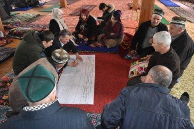
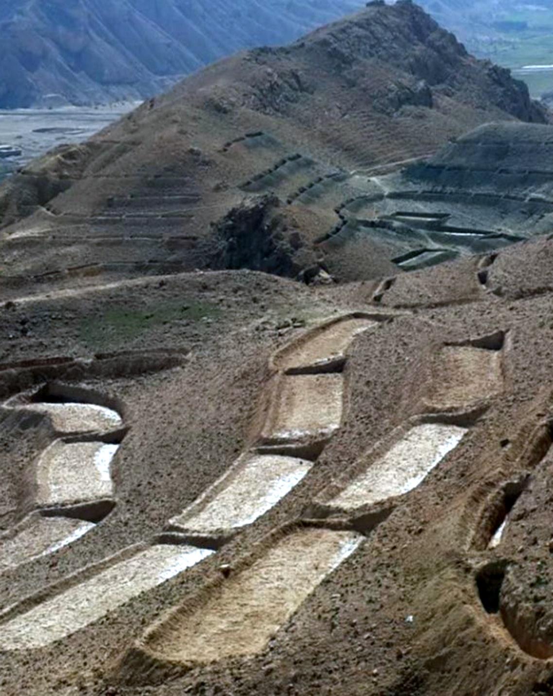
Establishment / maintenance activities and inputs: Having selected the watersheds and established watershed committees, watershed master plans were prepared and various structural and agronomical measures identified and estimated for each unit of land. Community laborers, trained by HELVETAS technical staff, constructed the terraces under supervision of watershed committee members. 600 terraces, each measuring 10 m x 3.6 m were constructed on seven hectares of land. To ensure maintenance, HELVETAS Swiss Intercooperation facilitated the creation of community saving systems and invested 10% of the project budget for maintenance of each watershed. It improved the capacity of watershed members, so after ending project support the community watershed committee would be able to manage maintenance of watershed measures.
Natural / human environment: Bamyan province is a remote province of Afghanistan with a high poverty rate. It has a semi-arid climate with cold winters and hot and dry summers. During winter, temperatures can drop below -22 degrees. Summer temperatures can reach 34 degrees in the month of July. The average annual rainfall in the area is about 230mm and some years can be very dry. 90% of the population relies on subsistence agriculture for their livelihoods and off-farm activities are marginal. The soil texture is clay, sandy loam and clay loam with moderate type of soil fertility, naked area of upper catchments causes that most of Saighan villages face to water scarcity during May to September and can’t grow valuable crops.The growing season in Saighan district is relatively short from April to October and farmers can produce only one crop per year. Farmers with access to irrigation water cultivate cash crops, for example potato and vegetables, in addition to staple crops (wheat) and fodder crops.Those without access to irrigation water cultivate wheat and fodder crops only. Water scarcity during May to September may result in a lack of high value crops.
The average annual income from one hectare in the area of having enough irrigation water is 250000 AFN (3676 USD) and in the area which has no enough irrigation water is 67500 AFN (992 USD).
2.3 Photos de la Technologie
Galerie Médias
2.5 Pays/ région/ lieux où la Technologie a été appliquée et qui sont couverts par cette évaluation
Pays:
Afghanistan
Région/ Etat/ Province:
Bamyan
Autres spécifications du lieu:
Saighan
2.6 Date de mise en œuvre de la Technologie
Si l'année précise est inconnue, indiquez la date approximative: :
- il y a moins de 10 ans (récemment)
2.7 Introduction de la Technologie
Spécifiez comment la Technologie a été introduite: :
- par le biais de projets/ d'interventions extérieures
Commentaires (type de projet, etc.) :
Since 2010
3. Classification de la Technologie de GDT
3.1 Principal(aux) objectif(s) de la Technologie
- améliorer la production
- réduire, prévenir, restaurer les terres dégradées
- réduire les risques de catastrophes
3.2 Type(s) actuel(s) d'utilisation des terres, là où la Technologie est appliquée

Pâturages
Pâturage extensif:
- Nomadisme
Commentaires:
Major land use problems (compiler’s opinion): Harvest of shrubs and over grazing for over 20 years resulted in the lost vegetation cover. Top soil erosion is severe and gullies are visible.
Major land use problems (land users’ perception): Due to the lack of alternatives for fuel and lack of opportunities for income during decades war, people were compelled to use the natural resources in the upper catchment areas.
Future (final) land use (after implementation of SLM Technology): Cropland: Cp: Perennial (non-woody) cropping
Si l'utilisation des terres a changé en raison de la mise en œuvre de la Technologie, indiquez l'utilisation des terres avant la mise en œuvre de la Technologie:
Grazing land: Ge: Extensive grazing land
3.3 Informations complémentaires sur l'utilisation des terres
Approvisionnement en eau des terres sur lesquelles est appliquée la Technologie:
- pluvial
Nombre de période de croissance par an: :
- 1
Précisez:
Longest growing period in days: 120; Longest growing period from month to month: March to July
Densité d'élevage/ chargement (si pertinent):
10-25 LU /km2
3.4 Groupe de GDT auquel appartient la Technologie
- mesures en travers de la pente
3.5 Diffusion de la Technologie
Spécifiez la diffusion de la Technologie:
- répartie uniformément sur une zone
Si la Technologie est uniformément répartie sur une zone, indiquez la superficie couverte approximative:
- 1-10 km2
3.6 Mesures de GDT constituant la Technologie

structures physiques
- S1: Terrasses
3.7 Principaux types de dégradation des terres traités par la Technologie

érosion hydrique des sols
- Wt: perte de la couche superficielle des sols (couche arable)/ érosion de surface
Commentaires:
Main causes of degradation: crop management (annual, perennial, tree/shrub) (Shrub cutting), overgrazing (Over grazing and no management), droughts (3 years drought), population pressure, war and conflicts (3 decades of civil war)
3.8 Prévention, réduction de la dégradation ou réhabilitation des terres dégradées
Spécifiez l'objectif de la Technologie au regard de la dégradation des terres:
- restaurer/ réhabiliter des terres sévèrement dégradées
Commentaires:
Secondary goals: prevention of land degradation, mitigation / reduction of land degradation
4. Spécifications techniques, activités, intrants et coûts de mise en œuvre
4.1 Dessin technique de la Technologie
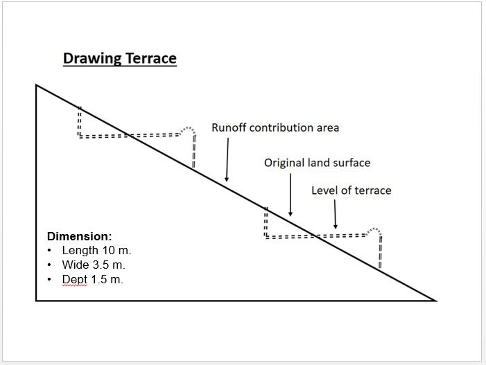
Auteur:
Shabir Shahem, HELVETAS Swiss Intercooperation, Afghanistan
4.2 Spécification/ explications techniques du dessin technique
Technical drawing of a terrace built in the watershed for the mean of vegetation.
Almost all the terraces constructed on the hill sides has 10 m length, 3.5 m width and 1.5 m depth.
Location: Saighan. Bamyan
Date: 19/04/2016
Technical knowledge required for field staff / advisors: high (In order to design well)
Technical knowledge required for land users: low
Main technical functions: control of dispersed runoff: impede / retard, reduction of slope angle, reduction of slope length, improvement of topsoil structure (compaction), increase of infiltration, increase / maintain water stored in soil, promotion of vegetation species and varieties (quality, eg palatable fodder)
Terrace: forward sloping
Vertical interval between structures (m): 1.8
Spacing between structures (m): 0.5
Depth of ditches/pits/dams (m): 0.3
Width of ditches/pits/dams (m): 3.6
Length of ditches/pits/dams (m): 10
Construction material (earth): Excuvation of soil and leveling
Slope (which determines the spacing indicated above): 15-30%
If the original slope has changed as a result of the Technology, the slope today is: 0%
Lateral gradient along the structure: 0%
Specification of dams/ pans/ ponds: Capacity 36m3
Catchment area: 36m2
4.3 Informations générales sur le calcul des intrants et des coûts
Indiquez la monnaie utilisée pour le calcul des coûts:
- dollars US
Indiquez le coût salarial moyen de la main d'œuvre par jour:
5.88
4.4 Activités de mise en place/ d'établissement
| Activité | Type de mesures | Calendrier | |
|---|---|---|---|
| 1. | Labor cost for the construction of the terraces | Structurel | 1 month |
4.5 Coûts et intrants nécessaires à la mise en place
| Spécifiez les intrants | Unité | Quantité | Coûts par unité | Coût total par intrant | % des coût supporté par les exploitants des terres | |
|---|---|---|---|---|---|---|
| Main d'œuvre | Labor cost for the construction of the terraces | persons/day | 1200,0 | 5,88 | 7056,0 | 10,0 |
| Coût total de mise en place de la Technologie | 7056,0 | |||||
4.6 Activités d'entretien/ récurrentes
| Activité | Type de mesures | Calendrier/ fréquence | |
|---|---|---|---|
| 1. | Repairing of few terraces after heavy rain falls | Structurel | 3 times a year |
4.7 Coûts et intrants nécessaires aux activités d'entretien/ récurrentes (par an)
| Spécifiez les intrants | Unité | Quantité | Coûts par unité | Coût total par intrant | % des coût supporté par les exploitants des terres | |
|---|---|---|---|---|---|---|
| Main d'œuvre | Repairing of few terraces | persons/day | 6,0 | 5,833333 | 35,0 | 100,0 |
| Coût total d'entretien de la Technologie | 35,0 | |||||
4.8 Facteurs les plus importants affectant les coûts
Décrivez les facteurs les plus importants affectant les coûts :
Labor cost is the determinate factors which was affecting the costs.
5. Environnement naturel et humain
5.1 Climat
Précipitations annuelles
- < 250 mm
- 251-500 mm
- 501-750 mm
- 751-1000 mm
- 1001-1500 mm
- 1501-2000 mm
- 2001-3000 mm
- 3001-4000 mm
- > 4000 mm
Zone agro-climatique
- semi-aride
Thermal climate class: temperate
5.2 Topographie
Pentes moyennes:
- plat (0-2 %)
- faible (3-5%)
- modéré (6-10%)
- onduleux (11-15%)
- vallonné (16-30%)
- raide (31-60%)
- très raide (>60%)
Reliefs:
- plateaux/ plaines
- crêtes
- flancs/ pentes de montagne
- flancs/ pentes de colline
- piémonts/ glacis (bas de pente)
- fonds de vallée/bas-fonds
Zones altitudinales:
- 0-100 m
- 101-500 m
- 501-1000 m
- 1001-1500 m
- 1501-2000 m
- 2001-2500 m
- 2501-3000 m
- 3001-4000 m
- > 4000 m
5.3 Sols
Profondeur moyenne du sol:
- très superficiel (0-20 cm)
- superficiel (21-50 cm)
- modérément profond (51-80 cm)
- profond (81-120 cm)
- très profond (>120 cm)
Texture du sol (de la couche arable):
- moyen (limoneux)
Matière organique de la couche arable:
- moyen (1-3%)
Si disponible, joignez une description complète du sol ou précisez les informations disponibles, par ex., type de sol, pH/ acidité du sol, capacité d'échange cationique, azote, salinité, etc.
Soil fertility is low
Soil drainage / infiltration is medium
Soil water storage capacity is medium
5.4 Disponibilité et qualité de l'eau
Profondeur estimée de l’eau dans le sol:
5-50 m
Disponibilité de l’eau de surface:
faible/ absente
Qualité de l’eau (non traitée):
uniquement pour usage agricole (irrigation)
5.5 Biodiversité
Diversité des espèces:
- faible
5.6 Caractéristiques des exploitants des terres appliquant la Technologie
Orientation du système de production:
- mixte (de subsistance/ commercial)
Revenus hors exploitation:
- 10-50% de tous les revenus
Individus ou groupes:
- groupe/ communauté
Genre:
- hommes
Indiquez toute autre caractéristique pertinente des exploitants des terres:
Land users applying the Technology are mainly common / average land users
Difference in the involvement of women and men: The culture doesn't allowed women to work as labor for construction works
Population density: 10-50 persons/km2
Annual population growth: 0.5% - 1%
Relative level of wealth: rich, average, poor
10% of the land users are rich (Households who have land and livestock).
35% of the land users are average wealthy (Households who have land only).
45% of the land users are poor (Howseholds who have less or not land).
5.7 Superficie moyenne des terres détenues ou louées par les exploitants appliquant la Technologie
- < 0,5 ha
- 0,5-1 ha
- 1-2 ha
- 2-5 ha
- 5-15 ha
- 15-50 ha
- 50-100 ha
- 100-500 ha
- 500-1 000 ha
- 1 000-10 000 ha
- > 10 000 ha
Cette superficie est-elle considérée comme de petite, moyenne ou grande dimension (en se référant au contexte local)?
- grande dimension
5.8 Propriété foncière, droits d’utilisation des terres et de l'eau
Propriété foncière:
- communauté/ village
Droits d’utilisation des terres:
- communautaire (organisé)
Droits d’utilisation de l’eau:
- communautaire (organisé)
5.9 Accès aux services et aux infrastructures
santé:
- pauvre
- modéré
- bonne
éducation:
- pauvre
- modéré
- bonne
assistance technique:
- pauvre
- modéré
- bonne
emploi (par ex. hors exploitation):
- pauvre
- modéré
- bonne
marchés:
- pauvre
- modéré
- bonne
énergie:
- pauvre
- modéré
- bonne
routes et transports:
- pauvre
- modéré
- bonne
eau potable et assainissement:
- pauvre
- modéré
- bonne
services financiers:
- pauvre
- modéré
- bonne
6. Impacts et conclusions
6.1 Impacts sur site que la Technologie a montrés
Impacts socio-économiques
Production
production agricole
Quantité avant la GDT:
60
Quantité après la GDT:
80
Commentaires/ spécifiez:
Technology reduce flood and lower lands doesnt effect by floods
Disponibilité et qualité de l'eau
disponibilité de l'eau d'irrigation
Quantité avant la GDT:
20
Quantité après la GDT:
25
Commentaires/ spécifiez:
Increasing under ground water by applying technology
Revenus et coûts
revenus agricoles
Quantité avant la GDT:
0
Quantité après la GDT:
50
Commentaires/ spécifiez:
Cultivation of cash crop in the terraces (farm income from uplands)
Impacts socioculturels
sécurité alimentaire/ autosuffisance
connaissances sur la GDT/ dégradation des terres
apaisement des conflits
situation des groupes socialement et économiquement désavantagés
livelihood and human well-being
Commentaires/ spécifiez:
The technology has effective role on reducing flash flood and as well through cultivation of valuable crops the community get more income from watershed area
Impacts écologiques
Cycle de l'eau/ ruissellement
récolte/ collecte de l'eau
ruissellement de surface
Quantité avant la GDT:
0
Quantité après la GDT:
100
Commentaires/ spécifiez:
Leveled terraces infilter the water
nappes phréatiques/ aquifères
Sols
humidité du sol
Quantité avant la GDT:
0
Quantité après la GDT:
50
Commentaires/ spécifiez:
Technology let the water infilteration more
couverture du sol
perte en sol
6.2 Impacts hors site que la Technologie a montrés
disponibilité de l'eau
inondations en aval
Quantité avant la GDT:
0
Quantité après la GDT:
50
Commentaires/ spécifiez:
Control runoff
6.3 Exposition et sensibilité de la Technologie aux changements progressifs et aux évènements extrêmes/catastrophes liés au climat (telles que perçues par les exploitants des terres)
Changements climatiques progressifs
Changements climatiques progressifs
| Saison | Type de changements/ extrêmes climatiques | Comment la Technologie fait-elle face à cela? | |
|---|---|---|---|
| températures annuelles | augmente | bien |
Extrêmes climatiques (catastrophes)
Catastrophes météorologiques
| Comment la Technologie fait-elle face à cela? | |
|---|---|
| pluie torrentielle locale | pas bien |
Catastrophes climatiques
| Comment la Technologie fait-elle face à cela? | |
|---|---|
| sécheresse | bien |
Catastrophes hydrologiques
| Comment la Technologie fait-elle face à cela? | |
|---|---|
| inondation générale (rivière) | pas bien |
Commentaires:
The annual rainfall should be considered according to the slope of the area while designing terrace.
6.4 Analyse coûts-bénéfices
Quels sont les bénéfices comparativement aux coûts de mise en place (du point de vue des exploitants des terres)?
Rentabilité à court terme:
légèrement positive
Rentabilité à long terme:
très positive
Quels sont les bénéfices comparativement aux coûts d'entretien récurrents (du point de vue des exploitants des terres)?
Rentabilité à court terme:
très positive
Rentabilité à long terme:
très positive
Commentaires:
The establishment cost of this technology seems to be high but once they are built they need very less maintenance cost with lots of benefits in the other hand.
6.5 Adoption de la Technologie
- plus de 50%
Si disponible, quantifiez (nombre de ménages et/ou superficie couverte):
444 households covering 100 percent of the stated area
Parmi tous ceux qui ont adopté la Technologie, combien d'entre eux l'ont fait spontanément, à savoir sans recevoir aucune incitation matérielle ou aucun paiement?
- 0-10%
Commentaires:
444 land user families have adopted the Technology with external material support
There is no trend towards spontaneous adoption of the Technology
Comments on adoption trend: Construction of terraces in the watershed requires lots of investment costs.
6.7 Points forts/ avantages/ possibilités de la Technologie
| Points forts/ avantages/ possibilités du point de vue de l'exploitant des terres |
|---|
|
Good measure that is easy to be applied by the people. How can they be sustained / enhanced? Conducting training and workshops for capacity building of the community members. |
|
The application of this technology results to the control of runoff and reduction of the flash flood. How can they be sustained / enhanced? More vegetative measures should be considered. |
| Points forts/ avantages/ possibilités du point de vue du compilateur ou d'une autre personne ressource clé |
|---|
|
A good technology for the better control of runoff and keeping the moisture. How can they be sustained / enhanced? Cultivation and sustainable maintenance of the plants in the terraces. |
|
Preparing and providing a good and proper place for cultivation and plantation. How can they be sustained / enhanced? Plantation of the local plants which has more resistance and are adaptable to the natural environment of Saighan district. |
|
Getting more income through cultivation of valuable crops. How can they be sustained / enhanced? Protection of cultivated seed from grazing animals |
6.8 Faiblesses/ inconvénients/ risques de la Technologie et moyens de les surmonter
| Faiblesses/ inconvénients/ risques du point de vue du compilateur ou d'une autre personne ressource clé | Comment peuvent-ils être surmontés? |
|---|---|
| Requires high investment and financial cost. | People should as well have contribution in the cost by providing the labor work. |
| In case the technical measures are not considered and applied properly it may increase infiltration and subsequently increases the soil moisture which may trigger landslide on slopes during rainfalls | High level of the technical staff and knowledge to be considered and as well the area should be studied and observed deeply. |
Liens et modules
Développer tout Réduire toutLiens
Resilient Watershed Management Plan [Tadjikistan]
The participatory watershed management plan (WMP) is an interdisciplinary approach at community level to raise awareness on the watershed management concept and improve understanding of the watershed approach in planning and management of natural resource.
- Compilateur : Askarsho Zevarshoev
Modules
Aucun module trouvé