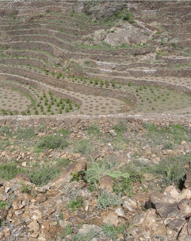
Bench terraces covered with small stones [Yémen]
- Création :
- Mise à jour :
- Compilateur : ahmed algalal
- Rédacteur : –
- Examinateurs : David Streiff, Alexandra Gavilano
المدرجات المغطاه بالأحجار
technologies_1560 - Yémen
Voir les sections
Développer tout Réduire tout1. Informations générales
1.2 Coordonnées des personnes-ressources et des institutions impliquées dans l'évaluation et la documentation de la Technologie
Spécialiste GDT:
Nom du ou des institutions qui ont facilité la documentation/ l'évaluation de la Technologie (si pertinent)
Agricultural Research and Extension Authority (AREA) - Yémen1.3 Conditions relatives à l'utilisation par WOCAT des données documentées
Le compilateur et la(les) personne(s) ressource(s) acceptent les conditions relatives à l'utilisation par WOCAT des données documentées:
Oui
1.5 Référence au(x) Questionnaires sur les Approches de GDT (documentées au moyen de WOCAT)
Building and rehabilitation of agricultural terraces. [Yémen]
Pay incentives for farmers rehabilitate degraded terraces in order to face the crisis of increasing food prices.
- Compilateur : ahmed algalal
2. Description de la Technologie de GDT
2.1 Courte description de la Technologie
Définition de la Technologie:
Building terraces in steep areas for the purpose of reducing the slope, water harvesting and soil moisture conservation.
2.2 Description détaillée de la Technologie
Description:
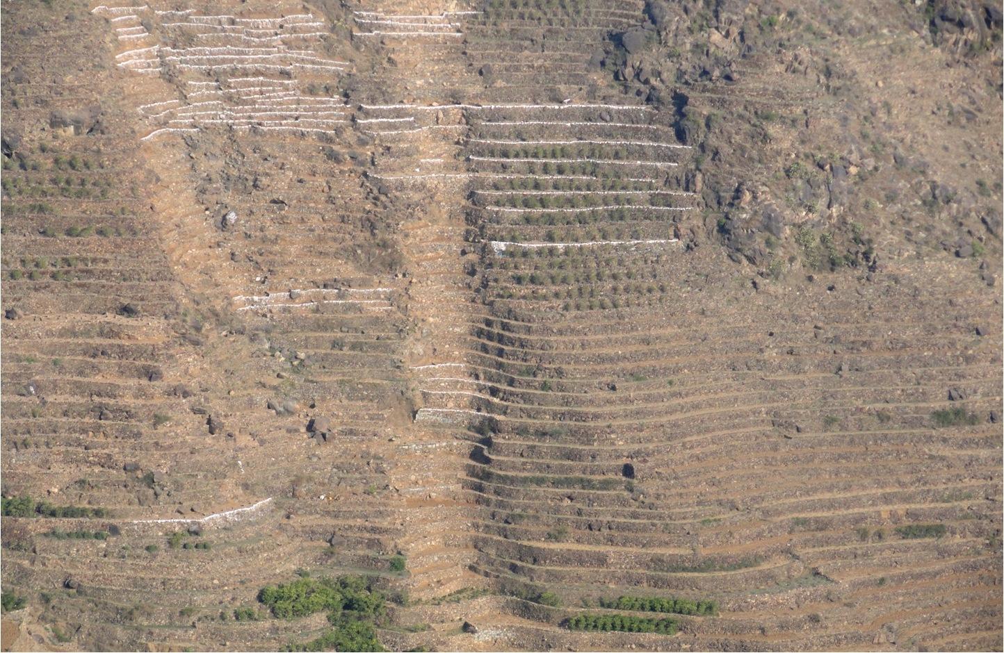
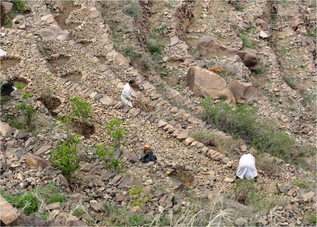
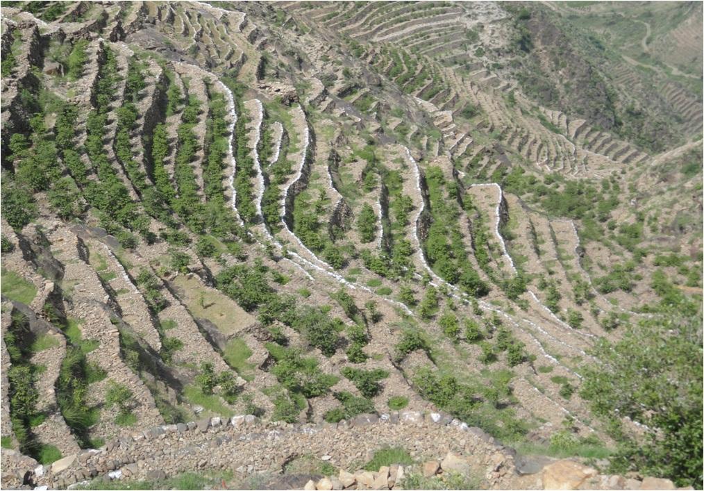
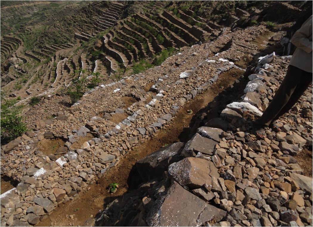
Cutting and collecting stones for the construction of terraces on steep slopes of the mountains, structural measure to reduce the length and angle of the slope and the speed of runoff. This makes it easier to harvest water and reserving deposits. A wall terraces is built of stones where the height of a wall should be increased height of 1.8 - 3 m, a width of 1.5 - 4.3 m and the length from 8 - 14 m to keep the accumulated deposits. The cutting stones are brought from distant places for the purpose of building the walls. These terraces are similar to mountain terraces but the top soil surface can be covered with stones to protect it from heavy rain storms and prevent sheet erosion that results from raindrops hitting the bare top soil surface. The stone layer, also prevents evaporation and maintains soil moisture. The stones are arranged in a layer of about 0.25 – 0.7 m thickness over the entire surface of the soil except where to put the coffee trees with an average diameter of 1 m. It is difficult to use equipment in the process of building the terraces due to severe slopes. Therefore it is a labor intensive process of manually building terraces. Due to the slow process of construction it requires a lot of time. However, building terraces on steep slopes can lead to increased erosion in the absence of well maintaining outlets that allow draining the excess water from one terrace to another, avoiding breaking of terraces' walls. In any case, terraces need regular maintenance to ensure the sustainability of this technology. The landscape of the region is mountainous, bench terraces which are used for crop production exist in slopes exceeding 60%. The texture of the soil is silty loam and the depth of the terraces is moderate to deep. Due to small holdings and steepness of the terraces, the local implements are used for land preparation. The climate in the region is arid to semi-arid and annual precipitation ranges between 200 and 450 mm. The major crop in this area is coffee, which is cultivated because of its high economic value on the market.
2.3 Photos de la Technologie
Galerie Médias
2.5 Pays/ région/ lieux où la Technologie a été appliquée et qui sont couverts par cette évaluation
Pays:
Yémen
Région/ Etat/ Province:
Sanaa governorate
Autres spécifications du lieu:
Bani Ismail- Manakha District
Spécifiez la diffusion de la Technologie:
- répartie uniformément sur une zone
S'il n'existe pas d'informations exactes sur la superficie, indiquez les limites approximatives de la zone couverte:
- 0,1-1 km2
Commentaires:
Bani Ismail's Uzlah is situated in west part of the capital Sana'a
Total area covered by the SLM Technology is 0.75 km2.
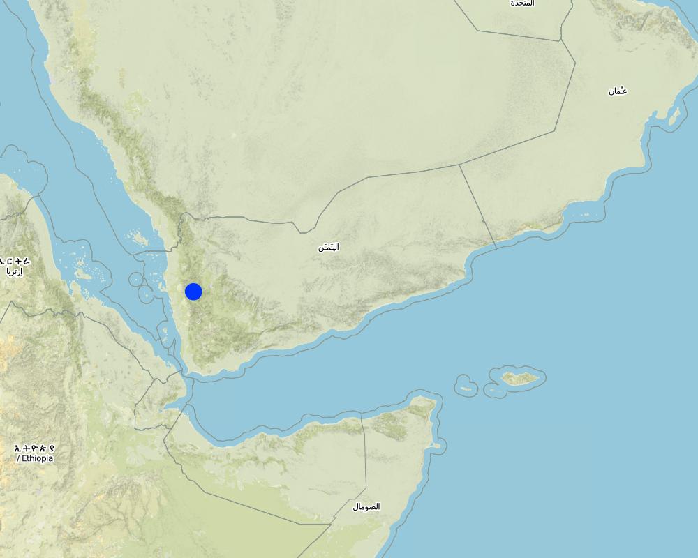
Map
×2.6 Date de mise en œuvre de la Technologie
Si l'année précise est inconnue, indiquez la date approximative: :
- il y a plus de 50 ans (technologie traditionnelle)
2.7 Introduction de la Technologie
Spécifiez comment la Technologie a été introduite: :
- dans le cadre d'un système traditionnel (> 50 ans)
Commentaires (type de projet, etc.) :
It is very ancient technology but was rehabilitated in 2011 by the users of the land by getting a fund from the Social Fund for Development
3. Classification de la Technologie de GDT
3.1 Principal(aux) objectif(s) de la Technologie
- réduire, prévenir, restaurer les terres dégradées
3.2 Type(s) actuel(s) d'utilisation des terres, là où la Technologie est appliquée

Terres cultivées
- Plantations d’arbres ou de buissons
Plantations d'arbres et d'arbustes - Précisez les cultures:
- café, cultivé en plein champ
Nombre de période de croissance par an: :
- 1
Précisez:
Longest growing period in days: 90
Commentaires:
Major land use problems (compiler’s opinion): Water erosion in the form of Gullies, large stones loss (landslides) due to the sever steepness in addition to low soil moisture.
Major land use problems (land users’ perception): Soil erosion
Future (final) land use (after implementation of SLM Technology): Cropland: Ct: Tree and shrub cropping
3.3 Est-ce que l’utilisation des terres a changé en raison de la mise en œuvre de la Technologie ?
Terres cultivées
- Plantations d’arbres ou de buissons
Commentaires:
Future (final) land use (after implementation of SLM Technology): Cropland: Ct: Tree and shrub cropping
3.4 Approvisionnement en eau
Approvisionnement en eau des terres sur lesquelles est appliquée la Technologie:
- pluvial
Commentaires:
Water supply: post-flooding
3.5 Groupe de GDT auquel appartient la Technologie
- mesures en travers de la pente
- récupération/ collecte de l'eau
- dérivation et drainage de l'eau
3.6 Mesures de GDT constituant la Technologie

structures physiques
- S1: Terrasses
3.7 Principaux types de dégradation des terres traités par la Technologie

érosion hydrique des sols
- Wg: ravinement/ érosion en ravines

dégradation biologique
- Bc: réduction de la couverture végétale

dégradation hydrique
- Ha: aridification
Commentaires:
Secondary types of degradation addressed: Ha: aridification
Main causes of degradation: Heavy / extreme rainfall (intensity/amounts) (Severe rainstorm), other natural causes (avalanches, volcanic eruptions, mud flows, highly susceptible natural resources, extreme topography, etc.) specify (Severe slopes and fall of large rock masses), land tenure (Fragmentation of holdings), Immigration and search for other income sources
Secondary causes of degradation: over-exploitation of vegetation for domestic use (For domestic use due to lack of gas as a fuel source), poverty / wealth (Poverty), education, access to knowledge and support services
3.8 Prévention, réduction de la dégradation ou réhabilitation des terres dégradées
Spécifiez l'objectif de la Technologie au regard de la dégradation des terres:
- réduire la dégradation des terres
- restaurer/ réhabiliter des terres sévèrement dégradées
4. Spécifications techniques, activités, intrants et coûts de mise en œuvre
4.1 Dessin technique de la Technologie
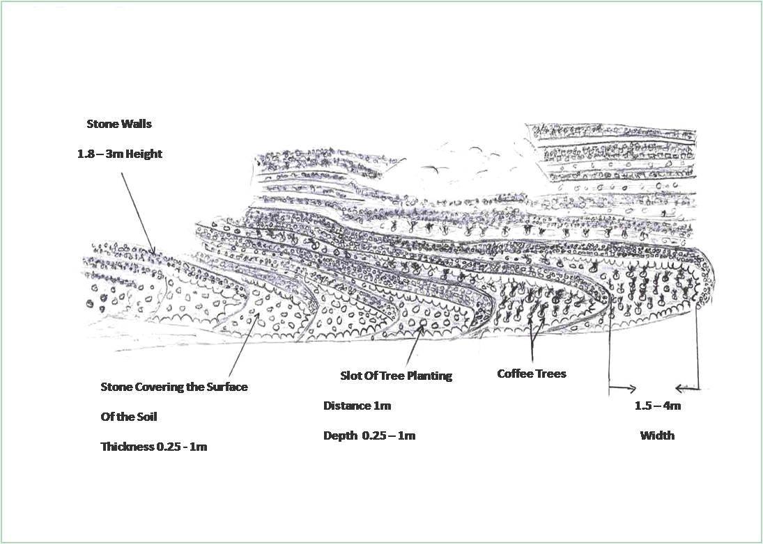
Spécifications techniques (associées au dessin technique):
Flat agricultural terraces covered with stones on the soil surface
Location: Bani Ismail. Sana'a governorate - Manakha district
Date: 5/3/2013
Technical knowledge required for field staff / advisors: high (Construction process needs skill and experience)
Technical knowledge required for land users: low (Has experience)
Main technical functions: control of raindrop splash, reduction of slope angle, reduction of slope length, increase / maintain water stored in soil, water harvesting / increase water supply, Reduce speed of runoff
Secondary technical functions: sediment retention / trapping, sediment harvesting
Terrace: bench level
Vertical interval between structures (m): 1.8 -3
Spacing between structures (m): 1.5 – 4.3
Height of bunds/banks/others (m): 1.8 -3
Width of bunds/banks/others (m): 1.5– 4.3
Length of bunds/banks/others (m): 8 - 14
Structural measure: The Coverage with stones
Width of bunds/banks/others (m): 1.5– 4.3
Length of bunds/banks/others (m): 8 - 14
Construction material (earth): Remove residuals of water erosion and refill the soil-eroded with soil
Construction material (stone): Construction of walls from the existing stones in the region
Slope (which determines the spacing indicated above): 66.7%
Lateral gradient along the structure: 0%
For water harvesting: the ratio between the area where the harvested water is applied and the total area from which water is collected is: 1:1
Auteur:
AL Galal
4.2 Informations générales sur le calcul des intrants et des coûts
Indiquez la monnaie utilisée pour le calcul des coûts:
- dollars américains
Indiquez le coût salarial moyen de la main d'œuvre par jour:
6.30
4.3 Activités de mise en place/ d'établissement
| Activité | Calendrier des activités (saisonnier) | |
|---|---|---|
| 1. | Remove the spate deposits and filing the gullies with soil, then the top soil surface has to be leveled | Before the rain season |
| 2. | Collecting and transporting stones | Before the rain season |
| 3. | Building the walls of the terraces | Before the rain season |
| 4. | Cover the top soil surface of the earth with stones | Before the rain season |
4.4 Coûts et intrants nécessaires à la mise en place
| Spécifiez les intrants | Unité | Quantité | Coûts par unité | Coût total par intrant | % des coût supporté par les exploitants des terres | |
|---|---|---|---|---|---|---|
| Main d'œuvre | Building terraces | ha | 1,0 | 42430,0 | 42430,0 | 11,0 |
| Equipements | Tools | ha | 1,0 | 100,0 | 100,0 | 100,0 |
| Coût total de mise en place de la Technologie | 42530,0 | |||||
| Coût total de mise en place de la Technologie en dollars américains (USD) | 42530,0 | |||||
Commentaires:
Duration of establishment phase: 7 month(s)
4.5 Activités d'entretien/ récurrentes
| Activité | Calendrier/ fréquence | |
|---|---|---|
| 1. | Repair walls that were destroyed | annually after the rain season |
| 2. | Inverse the soil covered with stones |
4.6 Coûts et intrants nécessaires aux activités d'entretien/ récurrentes (par an)
| Spécifiez les intrants | Unité | Quantité | Coûts par unité | Coût total par intrant | % des coût supporté par les exploitants des terres | |
|---|---|---|---|---|---|---|
| Main d'œuvre | Repair walls that were destroyed | ha | 1,0 | 50,0 | 50,0 | 100,0 |
| Main d'œuvre | Inverse the soil covered with stones | ha | 1,0 | 186,0 | 186,0 | 100,0 |
| Coût total d'entretien de la Technologie | 236,0 | |||||
| Coût total d'entretien de la Technologie en dollars américains (USD) | 236,0 | |||||
Commentaires:
It is important to note that the implemented works to achieved is about 6 hectare, the project which support money against work, contributed with 231720.54$ to cover most of works such as collecting and transfer stones, and constructing the wall of terraces at 16639.16 m, and covering soil surface with stones for an area estimated of 53560.08 m2. While the land users performed cleaning waste of constructions, filling the target area with soil and leveling it. The total cost of constructing per hectare for building walls terraces at 3273.2 m long and 1.8-3 m height and covering soil surface with stones for an area of 8926.68 m2, and 0.25-0.7 m thick, this cost including other works which already have discussion before.
4.7 Facteurs les plus importants affectant les coûts
Décrivez les facteurs les plus importants affectant les coûts :
1- Collecting and transporting stones and arable soil manually as a result of the bad road accessibility.
2- Severe steep slopes
5. Environnement naturel et humain
5.1 Climat
Précipitations annuelles
- < 250 mm
- 251-500 mm
- 501-750 mm
- 751-1000 mm
- 1001-1500 mm
- 1501-2000 mm
- 2001-3000 mm
- 3001-4000 mm
- > 4000 mm
Zone agro-climatique
- semi-aride
Thermal climate class: temperate
5.2 Topographie
Pentes moyennes:
- plat (0-2 %)
- faible (3-5%)
- modéré (6-10%)
- onduleux (11-15%)
- vallonné (16-30%)
- raide (31-60%)
- très raide (>60%)
Reliefs:
- plateaux/ plaines
- crêtes
- flancs/ pentes de montagne
- flancs/ pentes de colline
- piémonts/ glacis (bas de pente)
- fonds de vallée/bas-fonds
Zones altitudinales:
- 0-100 m
- 101-500 m
- 501-1000 m
- 1001-1500 m
- 1501-2000 m
- 2001-2500 m
- 2501-3000 m
- 3001-4000 m
- > 4000 m
Commentaires et précisions supplémentaires sur la topographie:
Altitudinal zone: 1400 m a.s.l.
5.3 Sols
Profondeur moyenne du sol:
- très superficiel (0-20 cm)
- superficiel (21-50 cm)
- modérément profond (51-80 cm)
- profond (81-120 cm)
- très profond (>120 cm)
Texture du sol (de la couche arable):
- moyen (limoneux)
Matière organique de la couche arable:
- faible (<1%)
Si disponible, joignez une description complète du sol ou précisez les informations disponibles, par ex., type de sol, pH/ acidité du sol, capacité d'échange cationique, azote, salinité, etc.
Soil depth on average: 150 cm
Soil texture: Flood deposits
Topsoil organic matter: Soil covered with stones except where the tree plantation
Soil fertility is low
Soil drainage / infiltration is medium - good
Soil water storage capacity is medium - high
5.4 Disponibilité et qualité de l'eau
Disponibilité de l’eau de surface:
faible/ absente
Qualité de l’eau (non traitée):
faiblement potable (traitement nécessaire)
5.5 Biodiversité
Diversité des espèces:
- faible
5.6 Caractéristiques des exploitants des terres appliquant la Technologie
Orientation du système de production:
- exploitation mixte (de subsistance/ commerciale)
Revenus hors exploitation:
- 10-50% de tous les revenus
Niveau relatif de richesse:
- pauvre
Individus ou groupes:
- groupe/ communauté
Niveau de mécanisation:
- travail manuel
- traction animale
Genre:
- hommes
Indiquez toute autre caractéristique pertinente des exploitants des terres:
Land users applying the Technology are mainly common / average land users
Difference in the involvement of women and men: Men have more experience and more power for work than the women.
Women carried out the weeding in the field in addition to food preparation at home.
Population density: 200-500 persons/km2
Annual population growth: 3% - 4%
10% of the land users are average wealthy and own 60% of the land.
90% of the land users are poor and own 40% of the land.
5.7 Superficie moyenne des terres utilisées par les exploitants des terres appliquant la Technologie
- < 0,5 ha
- 0,5-1 ha
- 1-2 ha
- 2-5 ha
- 5-15 ha
- 15-50 ha
- 50-100 ha
- 100-500 ha
- 500-1 000 ha
- 1 000-10 000 ha
- > 10 000 ha
Cette superficie est-elle considérée comme de petite, moyenne ou grande dimension (en se référant au contexte local)?
- moyenne dimension
5.8 Propriété foncière, droits d’utilisation des terres et de l'eau
Propriété foncière:
- individu, avec titre de propriété
Droits d’utilisation des terres:
- individuel
Droits d’utilisation de l’eau:
- communautaire (organisé)
5.9 Accès aux services et aux infrastructures
santé:
- pauvre
- modéré
- bonne
éducation:
- pauvre
- modéré
- bonne
assistance technique:
- pauvre
- modéré
- bonne
emploi (par ex. hors exploitation):
- pauvre
- modéré
- bonne
marchés:
- pauvre
- modéré
- bonne
énergie:
- pauvre
- modéré
- bonne
routes et transports:
- pauvre
- modéré
- bonne
eau potable et assainissement:
- pauvre
- modéré
- bonne
services financiers:
- pauvre
- modéré
- bonne
6. Impacts et conclusions
6.1 Impacts sur site que la Technologie a montrés
Impacts socio-économiques
Production
production agricole
risque d'échec de la production
surface de production
gestion des terres
Revenus et coûts
revenus agricoles
charge de travail
Autres impacts socio-économiques
Growth of weeds competing for water
Commentaires/ spécifiez:
Due to coverage of the top surface of soil with stones
Impacts socioculturels
sécurité alimentaire/ autosuffisance
connaissances sur la GDT/ dégradation des terres
apaisement des conflits
Commentaires/ spécifiez:
As a result of not repair the damage occurring in some of the terraces and that lead to the damage of other terraces.
Impacts écologiques
Cycle de l'eau/ ruissellement
récolte/ collecte de l'eau
ruissellement de surface
drainage de l'excès d'eau
évaporation
Sols
humidité du sol
couverture du sol
perte en sol
encroûtement/ battance du sol
compaction du sol
Autres impacts écologiques
soil fertility
6.2 Impacts hors site que la Technologie a montrés
inondations en aval
envasement en aval
6.3 Exposition et sensibilité de la Technologie aux changements progressifs et aux évènements extrêmes/catastrophes liés au climat (telles que perçues par les exploitants des terres)
Changements climatiques progressifs
Changements climatiques progressifs
| Saison | Augmentation ou diminution | Comment la Technologie fait-elle face à cela? | |
|---|---|---|---|
| températures annuelles | augmente | bien |
Extrêmes climatiques (catastrophes)
Catastrophes météorologiques
| Comment la Technologie fait-elle face à cela? | |
|---|---|
| pluie torrentielle locale | bien |
Catastrophes climatiques
| Comment la Technologie fait-elle face à cela? | |
|---|---|
| sécheresse | bien |
6.4 Analyse coûts-bénéfices
Quels sont les bénéfices comparativement aux coûts de mise en place (du point de vue des exploitants des terres)?
Rentabilité à court terme:
légèrement négative
Rentabilité à long terme:
positive
Quels sont les bénéfices comparativement aux coûts d'entretien récurrents (du point de vue des exploitants des terres)?
Rentabilité à court terme:
légèrement positive
Rentabilité à long terme:
positive
6.5 Adoption de la Technologie
- > 50%
Si disponible, quantifiez (nombre de ménages et/ou superficie couverte):
120 households covering 100 percent of the stated area
De tous ceux qui ont adopté la Technologie, combien d'entre eux l'ont fait spontanément, à savoir sans recevoir aucune incitation matérielle, ou aucune rémunération? :
- 0-10%
Commentaires:
120 land user families have adopted the Technology with external material support
There is a moderate trend towards spontaneous adoption of the Technology
The technology is one of the old folk traditions, but due to the deterioration of the living conditions of families and high maintenance costs the terraces left abandoned and when support is available by the government to help farmers rehabilitate and terraces rundown Reclamation. As for the adoption of the technique is essentially the traditional techniques of farmers and they have knowledge of their importance, but in the event of major damage farmers are unable to repair where it needs to expensive costs. Consequently, farmers have to leave and search for another source of income through internal migration. Such as these damages do not happen like this only in the event of a heavy rainstorms and it is very rare, which leads to washed and destroyed many of the terraces. Consequently, the farmer cannot repair the damage by himself. As previously stated it was targeting a group of land users who do not applied to the project to ask for help.
6.7 Points forts/ avantages/ possibilités de la Technologie
| Points forts/ avantages/ possibilités du point de vue du compilateur ou d'une autre personne ressource clé |
|---|
|
This ancient technology is original and appropriate to the local situation How can they be sustained / enhanced? Raise awareness among land users of the importance of maintaining the technology. |
|
The sustainable cropping of the soil terraces on steep slopes prevent soil loss and degradation How can they be sustained / enhanced? Continue maintenance and appropriate land management |
|
Increase soil moisture How can they be sustained / enhanced? Periodic maintenance |
|
Reducing runoff and increasing water harvesting How can they be sustained / enhanced? Periodic maintenance |
|
Improve soil fertility How can they be sustained / enhanced? Continue to add organic matter to increase soil fertility and conservation |
6.8 Faiblesses/ inconvénients/ risques de la Technologie et moyens de les surmonter
| Faiblesses/ inconvénients/ risques du point de vue du compilateur ou d'une autre personne ressource clé | Comment peuvent-ils être surmontés? |
|---|---|
| The high cost of rehabilitation and maintenance of the terraces by an individual user | Strengthening cooperation and assistance in the rehabilitation and maintenance collectively by land users |
| High runoff may lead to the erosion of terraces | Planting the upper part of higher slopes with trees or water breakers (controls) for water runoff to reduce the flow velocity, as well as periodic maintenance of watercourses and water outlets in the terraces |
| Cover the surface of the soil with stones may lead to soil compaction | To avoid compaction due to covering soil with stones reduce the thickness of this layer |
7. Références et liens
7.1 Méthodes/ sources d'information
7.2 Références des publications disponibles
Titre, auteur, année, ISBN:
Technical study for construction and reclamation for terraces in some villages, Bani Ismail's uzlah, Manakhah district.2- Mid-monthly reports for implanting terraces construction in Bani Ismail's uzlah, Manakhah district.3- General Census of Population, Housing and Establishment (Census, 2004).4- Guide of agricultural climate in Yemen (Al Khorasani, 2005).
Disponible à partir d'où? Coût?
Social Fund for Development, Sana'a 976714496722- Social Fund for Development, Sana'a 97671449672 3-Central Bureau of Statistics4-Agricultural Research and Extension Authority, AREA
Liens et modules
Développer tout Réduire toutLiens
Building and rehabilitation of agricultural terraces. [Yémen]
Pay incentives for farmers rehabilitate degraded terraces in order to face the crisis of increasing food prices.
- Compilateur : ahmed algalal
Modules
Aucun module trouvé