Irrigated agro-biodiversity system in arid high mountain area [Tadjikistan]
- Création :
- Mise à jour :
- Compilateur : Gulniso Nekushoeva
- Rédacteur : –
- Examinateurs : David Streiff, Alexandra Gavilano
technologies_1034 - Tadjikistan
Voir les sections
Développer tout Réduire tout1. Informations générales
1.2 Coordonnées des personnes-ressources et des institutions impliquées dans l'évaluation et la documentation de la Technologie
Spécialiste GDT:
Spécialiste GDT:
Nom du ou des institutions qui ont facilité la documentation/ l'évaluation de la Technologie (si pertinent)
Tajik Soil Insitute (Tajik Soil Institute) - TadjikistanNom du ou des institutions qui ont facilité la documentation/ l'évaluation de la Technologie (si pertinent)
CDE Centre for Development and Environment (CDE Centre for Development and Environment) - SuisseNom du ou des institutions qui ont facilité la documentation/ l'évaluation de la Technologie (si pertinent)
Tajik Academy of Agricultural Sciences (Tajik Academy of Agricultural Sciences) - Tadjikistan1.3 Conditions relatives à l'utilisation par WOCAT des données documentées
Le compilateur et la(les) personne(s) ressource(s) acceptent les conditions relatives à l'utilisation par WOCAT des données documentées:
Oui
2. Description de la Technologie de GDT
2.1 Courte description de la Technologie
Définition de la Technologie:
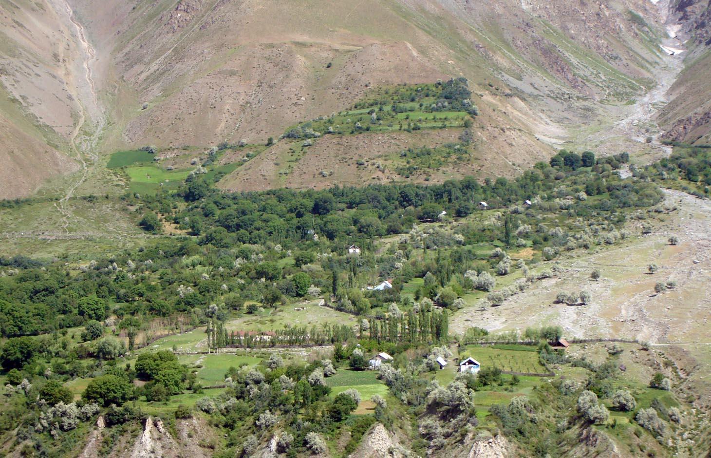
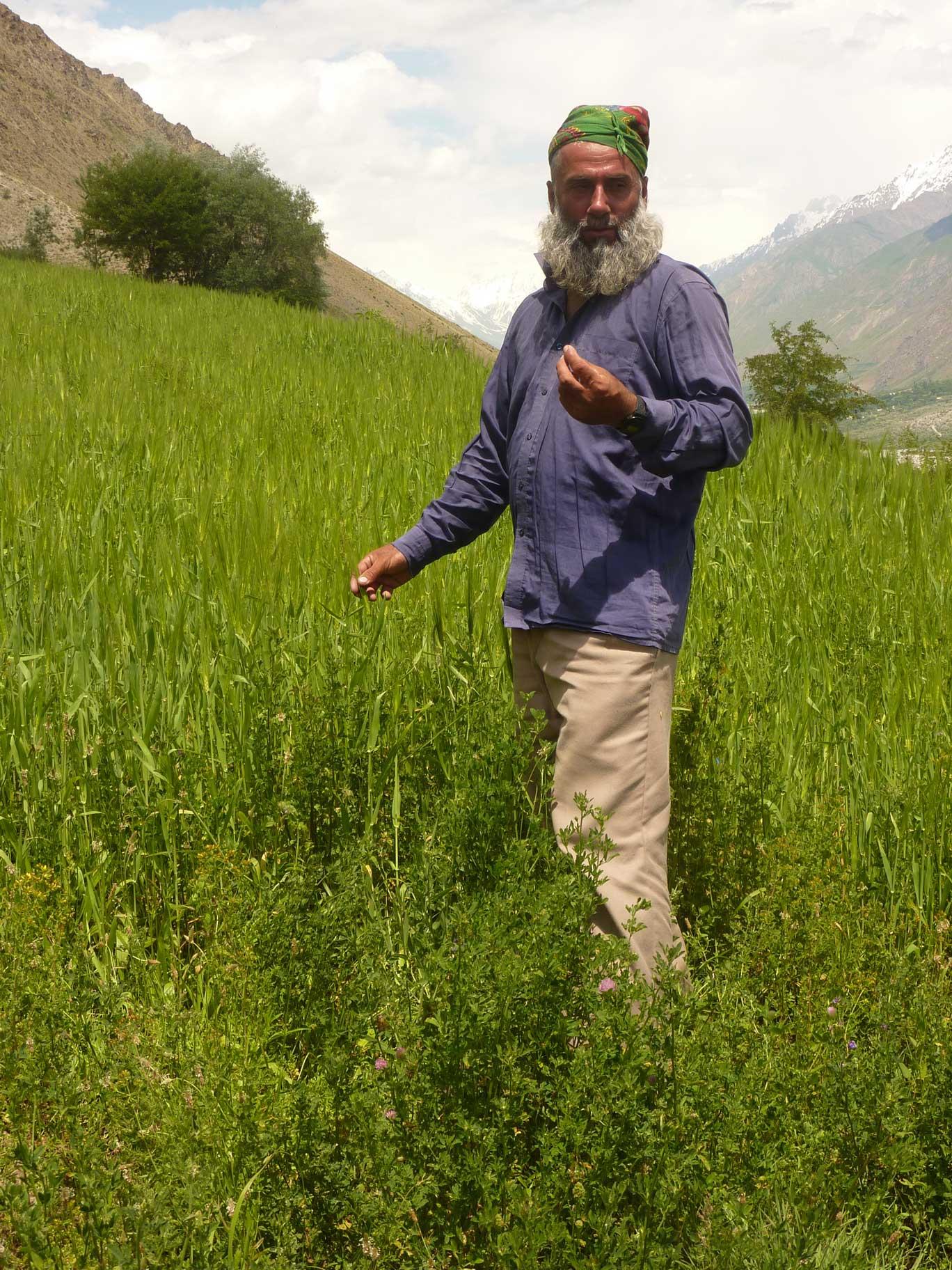
An individual farmer family, has changed an overgrazed pasture area on a steep slope in the upper part of the village into an irrigated agro-biodiversity system, by constructing an irrigation canal, by tilling and removing stones from the terraces for crop production and afforesting the surrounding area with fruit trees and bushes.
2.2 Description détaillée de la Technologie
Description:
Establishment / maintenance activities and inputs: The site was established in 1989, with the construction of an irrigation canal. The canal brings water from a small watershed and the slowly melting snow fields within. In years with limited snowfall, the water is insufficient for irrigation throughout the summer months.It is a open, mud canal, 730 m long. When establishing new cropland, removal of stones from the plots is the most laborious part of the work. After an initial removal of stones, the land is tilled and appearing stones are again removed. This process is repeated several times.
Year round maintenance work is required to keep the canal functioning. Maintenance work on the cropland includes stone removal, manuring of potatoes fields, weeding and tilling.
2.3 Photos de la Technologie
Galerie Médias
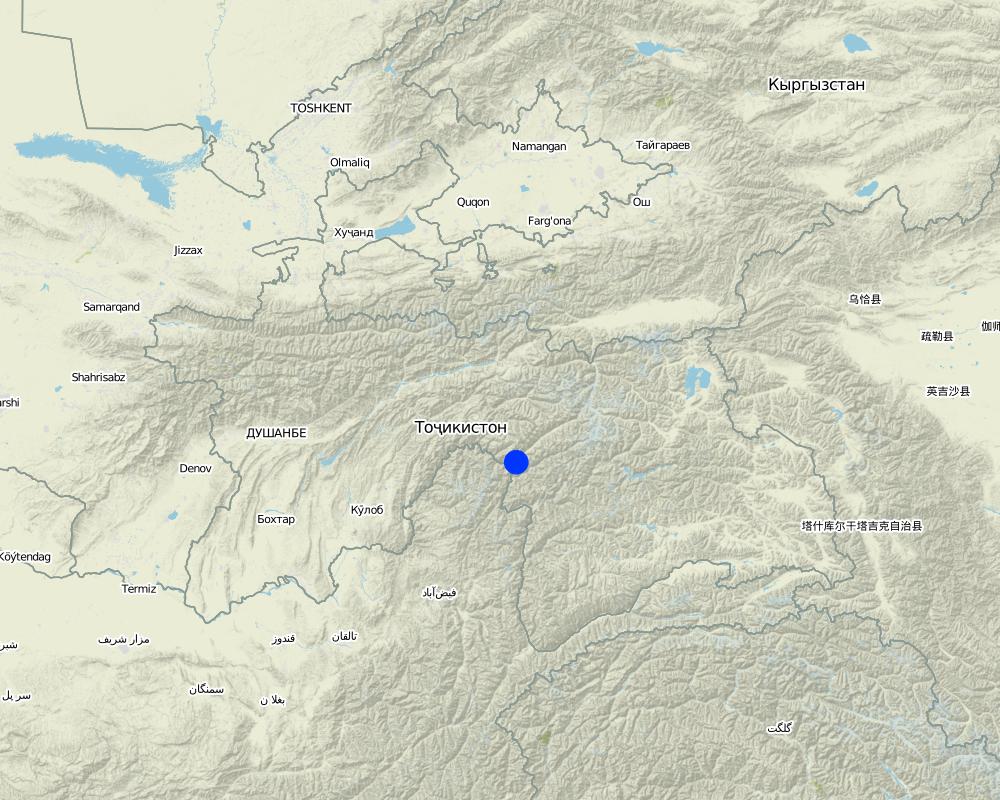
2.5 Pays/ région/ lieux où la Technologie a été appliquée et qui sont couverts par cette évaluation
Pays:
Tadjikistan
Région/ Etat/ Province:
GBAO
Autres spécifications du lieu:
Vanj / Udob / Trit
Spécifiez la diffusion de la Technologie:
- répartie uniformément sur une zone
S'il n'existe pas d'informations exactes sur la superficie, indiquez les limites approximatives de la zone couverte:
- < 0,1 km2 (10 ha)
Commentaires:
This technology can be found all along Vanj valley.
Map
×2.6 Date de mise en œuvre de la Technologie
Si l'année précise est inconnue, indiquez la date approximative: :
- il y a plus de 50 ans (technologie traditionnelle)
2.7 Introduction de la Technologie
Spécifiez comment la Technologie a été introduite: :
- dans le cadre d'un système traditionnel (> 50 ans)
Commentaires (type de projet, etc.) :
A traditional agroforestry system is implemented on a steep slope above the village, as there is a lack of flatter cropland. This requires improved and carefully adapted land practices.
3. Classification de la Technologie de GDT
3.1 Principal(aux) objectif(s) de la Technologie
- améliorer la production
- préserver l'écosystème
3.2 Type(s) actuel(s) d'utilisation des terres, là où la Technologie est appliquée
Les divers types d'utilisation des terres au sein du même unité de terrain: :
Oui
Précisez l'utilisation mixte des terres (cultures/ pâturages/ arbres):
- Agroforesterie

Terres cultivées
- Cultures annuelles
- Cultures pérennes (non ligneuses)
- Plantations d’arbres ou de buissons
Cultures annuelles - Précisez les cultures:
- céréales - blé de printemps
- céréales - blé d'hiver
- cultures fourragères - luzerne
- plantes à racines et à tubercules - pommes de terre
- vegetables, sea-buckthorn
Plantations d'arbres et d'arbustes - Précisez les cultures:
- fruits à pépins (pommes, poires, coings, etc.)
- fruits à noyaux (pêche, abricot, cerise, prune)
- fruits à coque (noix du Brésil, pistaches, noyers de bancoule, amandes)
Nombre de période de croissance par an: :
- 1
Précisez:
Longest growing period in days: 150Longest growing period from month to month: May - September

Forêts/ bois
- willow, "sangid", "Jachman bushes", "Kort (big bush)"; withthorn, dog rose
Produits et services:
- Fruits et noix
Commentaires:
Major land use problems (compiler’s opinion): Water scarcity is the major factor limiting vegetation growth and agricultural production in this arid areas. The soils are stony and slopes are steep (20-30 degrees).
The area is irrigated from streams fed by snow and glacier melting, and therefore water availability is strongly depending on yearly snow precipitation. If due to climate change snowfalls are decreasing in the future, this is a threat for agriculture in the region.
Major land use problems (land users’ perception): As the area is on steep slopes there is a high risk of small land slides triggered by irrigation. Fast snow melting in spring time may also cause land slides.
Future (final) land use (after implementation of SLM Technology): Mixed: Mf: Agroforestry
Type of cropping system and major crops comments: Old wallnut forests are used for agroforestry: there are potato, wheat, alfa-alfa and vegetable gardens below the nut trees.
Newly irrigated areas, are without wallnut trees and used for annual cropping and for perennial cropping.
Livestock is grazing on crop residues
3.3 Est-ce que l’utilisation des terres a changé en raison de la mise en œuvre de la Technologie ?
Est-ce que l’utilisation des terres a changé en raison de la mise en œuvre de la Technologie ?
- Oui (Veuillez remplir les questions ci-après au regard de l’utilisation des terres avant la mise en œuvre de la Technologie)

Pâturages
Commentaires:
Extensive grazing land
3.4 Approvisionnement en eau
Approvisionnement en eau des terres sur lesquelles est appliquée la Technologie:
- pleine irrigation
3.5 Groupe de GDT auquel appartient la Technologie
- agroforesterie
- mesures en travers de la pente
- gestion de l'irrigation (incl. l'approvisionnement en eau, le drainage)
3.6 Mesures de GDT constituant la Technologie

pratiques agronomiques
- A1: Couverture végétale/ du sol
- A2: Matière organique/ fertilité du sol

pratiques végétales
- V1: Couverture d’arbres et d’arbustes
- V2: Herbes et plantes herbacées pérennes

structures physiques
- S1: Terrasses

modes de gestion
- M1: Changement du type d’utilisation des terres
- M2: Changement du niveau de gestion / d'intensification
- M3: Disposition/plan en fonction de l'environnement naturel et humain
Commentaires:
Main measures: management measures
Secondary measures: agronomic measures, vegetative measures, structural measures
Type of agronomic measures: manure / compost / residues, mineral (inorganic) fertilizers, breaking crust / sealed surface, breaking compacted topsoil, contour tillage
Type of vegetative measures: aligned: -contour, scattered / dispersed
3.7 Principaux types de dégradation des terres traités par la Technologie

érosion hydrique des sols
- Wt: perte de la couche superficielle des sols (couche arable)/ érosion de surface
- Wm: mouvements de masse/ glissements de terrain

dégradation chimique des sols
- Cn: baisse de la fertilité des sols et réduction du niveau de matière organique (non causée par l’érosion)

dégradation physique des sols
- Pc: compaction

dégradation biologique
- Bc: réduction de la couverture végétale
- Bh: perte d’habitats
- Bq: baisse de la quantité/ biomasse
- Bs: baisse de la qualité et de la composition/ diversité des espèces
- Bl: perte de la vie des sols
Commentaires:
Main type of degradation addressed: Wm: mass movements / landslides, Cn: fertility decline and reduced organic matter content, Bc: reduction of vegetation cover, Bq: quantity / biomass decline, Bs: quality and species composition /diversity decline
Secondary types of degradation addressed: Wt: loss of topsoil / surface erosion, Pc: compaction, Bh: loss of habitats, Bl: loss of soil life
Main causes of degradation: overgrazing, droughts (in years with droughts part of the perennial vegetation may dry up), land tenure (common grazing land), inputs and infrastructure: (roads, markets, distribution of water points, other, …) (access to irrigation water, access to markets)
Secondary causes of degradation: poverty / wealth (early grazing, overgrazing), labour availability (mostly manual work and thus labour intensiv), governance / institutional (limited access to market, no water association)
3.8 Prévention, réduction de la dégradation ou réhabilitation des terres dégradées
Spécifiez l'objectif de la Technologie au regard de la dégradation des terres:
- réduire la dégradation des terres
Commentaires:
Main goals: mitigation / reduction of land degradation
4. Spécifications techniques, activités, intrants et coûts de mise en œuvre
4.1 Dessin technique de la Technologie
Spécifications techniques (associées au dessin technique):
Technical knowledge required for land users: moderate (Vast practical knowledge is required, through practical experiments, the practices were improved over time.)
Main technical functions: improvement of ground cover, improvement of topsoil structure (compaction), increase in organic matter, increase of biomass (quantity), promotion of vegetation species and varieties (quality, eg palatable fodder), spatial arrangement and diversification of land use
Secondary technical functions: control of raindrop splash, control of dispersed runoff: impede / retard, control of concentrated runoff: drain / divert, stabilisation of soil (eg by tree roots against land slides), increase in nutrient availability (supply, recycling,…), increase of infiltration, increase / maintain water stored in soil
Agronomic measure: crop rotation on wheat fields
Material/ species: perennial fodder plants (alfa-alfa)
Remarks: high density of alfa-alfa plants
Manure / compost / residues
Material/ species: cow manure
Quantity/ density: 15
Remarks: for patatoe fields
Mineral (inorganic) fertilizers
Material/ species: "super phosphat" or "silitra"
Quantity/ density: 0.025
Remarks: for wheat fields
Breaking crust / sealed surface
Material/ species: tilling using 2 ochs
Remarks: for wheat and patatoe fields
Breaking compacted topsoil
Material/ species: tilling using 2 ochs
Remarks: for wheat and patatoe fields
Contour tillage
Material/ species: tilling using 2 ochs
Remarks: for wheat and patatoe fields
Aligned: -contour
Vegetative material: T : trees / shrubs, F : fruit trees / shrubs, G : grass
Scattered / dispersed
Vegetative material: T : trees / shrubs, F : fruit trees / shrubs, G : grass
Trees/ shrubs species: willow, "sangid", "Jachman bushes", "Kort (big bush)";
Fruit trees / shrubs species: sea-buckthorn, walnut, plum, appel, pear, apricot, mirabelle, whitethorn, cherry, dog rose
Grass species: graminoids and legumes
Diversion ditch/ drainage
Depth of ditches/pits/dams (m): 0.3
Width of ditches/pits/dams (m): 0.5
Length of ditches/pits/dams (m): 2500
Waterway
Depth of ditches/pits/dams (m): 0.5
Width of ditches/pits/dams (m): 1
Length of ditches/pits/dams (m): 750
Construction material (earth): The waterways are all dug into the ground, and are mostly fortified with bushes and trees.
Vegetation is used for stabilisation of structures.
Change of land use type: extensive grazing to agroforestry
Layout change according to natural and human environment: carefully designed layout taking advantage of flatter areas for cultivation of annual crops, and protecting steep slopes with perennial tree and bush cover
Control / change of species composition: mix of cultivated and wild plants (trees, bushes and grasses)
4.2 Informations générales sur le calcul des intrants et des coûts
autre/ monnaie nationale (précisez):
Tajik Somoni
Indiquez le taux de change des USD en devise locale, le cas échéant (p.ex. 1 USD = 79.9 réal brésilien): 1 USD = :
4,4
Indiquez le coût salarial moyen de la main d'œuvre par jour:
30.00
4.3 Activités de mise en place/ d'établissement
| Activité | Calendrier des activités (saisonnier) | |
|---|---|---|
| 1. | Planting of willows, cherry, pears | spring |
| 2. | Construction of irrigation canal | autumn |
| 3. | Construction of on-farm water distribution network | spring |
| 4. | Alfa-alfa seeds (12kg/ha) | for 4 years, then can produce own seeds |
4.4 Coûts et intrants nécessaires à la mise en place
| Spécifiez les intrants | Unité | Quantité | Coûts par unité | Coût total par intrant | % du coût supporté par les exploitants des terres | |
|---|---|---|---|---|---|---|
| Main d'œuvre | Planting of willows, cherry, pears | Persons/day | 1,0 | 100,0 | ||
| Main d'œuvre | Construction irrigation canal | Persons/day | 100,0 | 30,0 | 3000,0 | 100,0 |
| Main d'œuvre | Construction of on-farm water distribution network | Persons/day | 30,0 | 30,0 | 900,0 | |
| Matériel végétal | Alfa-alfa seeds | kg/ha | 6,0 | 20,0 | 120,0 | 100,0 |
| Coût total de mise en place de la Technologie | 4020,0 | |||||
| Coût total de mise en place de la Technologie en dollars américains (USD) | 913,64 | |||||
4.5 Activités d'entretien/ récurrentes
| Activité | Calendrier/ fréquence | |
|---|---|---|
| 1. | Wheat (barley) sowing | anually |
| 2. | Wheat (barley) sowing | |
| 3. | Tilling potato fields | 3 times per growing season |
| 4. | Irrigating wheat (barley, alfa-alfa) | times per growing season |
| 5. | Planting potato | during planting |
| 6. | Planting potato | |
| 7. | Applying fertilizer to wheat fields | 3 times per growing period |
| 8. | Maintenance of canal and on-farm water distribution network | spring and after rains |
4.6 Coûts et intrants nécessaires aux activités d'entretien/ récurrentes (par an)
| Spécifiez les intrants | Unité | Quantité | Coûts par unité | Coût total par intrant | % du coût supporté par les exploitants des terres | |
|---|---|---|---|---|---|---|
| Main d'œuvre | Sowing wheat with ochses | Persons/day | 1,0 | 40,0 | 40,0 | 100,0 |
| Main d'œuvre | Tilling with ochses | Persons/day | 6,0 | 40,0 | 240,0 | |
| Main d'œuvre | Irrigating wheat, barley alfalfa | Persons/day | 6,0 | 30,0 | 180,0 | |
| Main d'œuvre | Planting potatoe | Persons/day | 8,0 | 30,0 | 240,0 | |
| Equipements | Ochses for wheat sowing | Ochses/ha | 2,0 | 50,0 | 100,0 | 100,0 |
| Equipements | Ochses for potatoe tilling | Ochses/ha | 6,0 | 30,0 | 180,0 | 100,0 |
| Equipements | Donkey for carrying dung to the fields | loads | 120,0 | 0,66666 | 80,0 | |
| Equipements | Labour: Going with donkeys | Persons/day | 8,0 | 40,0 | 320,0 | |
| Matériel végétal | Wheat seeds | kg | 200,0 | 1,2 | 240,0 | |
| Engrais et biocides | Compost/manure | tons | 12,0 | 50,0 | 600,0 | |
| Engrais et biocides | Poatoe seedling | kg | 800,0 | 1,0 | 800,0 | |
| Engrais et biocides | Fertilizer for wheats | kg | 140,0 | 0,58571 | 82,0 | |
| Coût total d'entretien de la Technologie | 3102,0 | |||||
| Coût total d'entretien de la Technologie en dollars américains (USD) | 705,0 | |||||
Commentaires:
Costs were calculated fro an area of 5 ha. The length of the irrigation channel from the creek to the plot is 730 m.
4.7 Facteurs les plus importants affectant les coûts
Décrivez les facteurs les plus importants affectant les coûts :
With regard to the establishment costs, the most determining factors are: the distance to the creek from where water is channeled away and the steepness of the slope and amount of stones when preparing the land for annual cropping. With regard to the maintenance costs it is the exposure of the water channel to rock fall and small land slides.
5. Environnement naturel et humain
5.1 Climat
Précipitations annuelles
- < 250 mm
- 251-500 mm
- 501-750 mm
- 751-1000 mm
- 1001-1500 mm
- 1501-2000 mm
- 2001-3000 mm
- 3001-4000 mm
- > 4000 mm
Spécifications/ commentaires sur les précipitations:
Most of the precipitation consits of snow, the main rainfall period is March / April
Zone agro-climatique
- aride
Thermal climate class: temperate. high mountain area
A2240 m asl
gricultural areas need irrigation, which is supplied by snow and glacier melt
5.2 Topographie
Pentes moyennes:
- plat (0-2 %)
- faible (3-5%)
- modéré (6-10%)
- onduleux (11-15%)
- vallonné (16-30%)
- raide (31-60%)
- très raide (>60%)
Reliefs:
- plateaux/ plaines
- crêtes
- flancs/ pentes de montagne
- flancs/ pentes de colline
- piémonts/ glacis (bas de pente)
- fonds de vallée/bas-fonds
Zones altitudinales:
- 0-100 m
- 101-500 m
- 501-1000 m
- 1001-1500 m
- 1501-2000 m
- 2001-2500 m
- 2501-3000 m
- 3001-4000 m
- > 4000 m
Commentaires et précisions supplémentaires sur la topographie:
Altitudinal zone: 2240 m a.s.l.
5.3 Sols
Profondeur moyenne du sol:
- très superficiel (0-20 cm)
- superficiel (21-50 cm)
- modérément profond (51-80 cm)
- profond (81-120 cm)
- très profond (>120 cm)
Texture du sol (de la couche arable):
- moyen (limoneux)
Matière organique de la couche arable:
- moyen (1-3%)
Si disponible, joignez une description complète du sol ou précisez les informations disponibles, par ex., type de sol, pH/ acidité du sol, capacité d'échange cationique, azote, salinité, etc.
Soil fertility is low
Soil drainage / infiltration is good
Soil water storage capacity is medium
5.4 Disponibilité et qualité de l'eau
Profondeur estimée de l’eau dans le sol:
5-50 m
Disponibilité de l’eau de surface:
moyenne
Qualité de l’eau (non traitée):
eau potable
5.5 Biodiversité
Diversité des espèces:
- moyenne
5.6 Caractéristiques des exploitants des terres appliquant la Technologie
Orientation du système de production:
- subsistance (auto-approvisionnement)
- exploitation mixte (de subsistance/ commerciale)
Revenus hors exploitation:
- moins de 10% de tous les revenus
Niveau relatif de richesse:
- moyen
Individus ou groupes:
- individu/ ménage
Niveau de mécanisation:
- travail manuel
- traction animale
Genre:
- hommes
Indiquez toute autre caractéristique pertinente des exploitants des terres:
Land users applying the Technology are mainly common / average land users
Population density: 10-50 persons/km2
Annual population growth: 1% - 2%
5% of the land users are very rich.
10% of the land users are rich.
70% of the land users are average wealthy.
15% of the land users are poor.
10% of the land users are poor.
Off-farm income specification: The here described farmers family has very limited off-farm income. The farm provides sufficient fuel, fodder, fruits and potatoes for subsistence farming.
In general, seasonal migration to Russia is widespread in the area, which provides additional income in form of remittances. Only households with only young children, elderly and sick persons have no family member working in Russian.
Level of mechanization: One uses ochses for plowing, motorized is really rare.
5.7 Superficie moyenne des terres utilisées par les exploitants des terres appliquant la Technologie
- < 0,5 ha
- 0,5-1 ha
- 1-2 ha
- 2-5 ha
- 5-15 ha
- 15-50 ha
- 50-100 ha
- 100-500 ha
- 500-1 000 ha
- 1 000-10 000 ha
- > 10 000 ha
Cette superficie est-elle considérée comme de petite, moyenne ou grande dimension (en se référant au contexte local)?
- petite dimension
5.8 Propriété foncière, droits d’utilisation des terres et de l'eau
Propriété foncière:
- état
Droits d’utilisation des terres:
- individuel
Droits d’utilisation de l’eau:
- individuel
Commentaires:
The land use right for the individual farmer is documented with an official land user certificate.
Water use right has been agreed on with the village council.
5.9 Accès aux services et aux infrastructures
santé:
- pauvre
- modéré
- bonne
éducation:
- pauvre
- modéré
- bonne
assistance technique:
- pauvre
- modéré
- bonne
emploi (par ex. hors exploitation):
- pauvre
- modéré
- bonne
marchés:
- pauvre
- modéré
- bonne
énergie:
- pauvre
- modéré
- bonne
routes et transports:
- pauvre
- modéré
- bonne
eau potable et assainissement:
- pauvre
- modéré
- bonne
services financiers:
- pauvre
- modéré
- bonne
6. Impacts et conclusions
6.3 Exposition et sensibilité de la Technologie aux changements progressifs et aux évènements extrêmes/catastrophes liés au climat (telles que perçues par les exploitants des terres)
Changements climatiques progressifs
Changements climatiques progressifs
| Saison | Augmentation ou diminution | Comment la Technologie fait-elle face à cela? | |
|---|---|---|---|
| températures annuelles | augmente | bien |
Extrêmes climatiques (catastrophes)
Catastrophes météorologiques
| Comment la Technologie fait-elle face à cela? | |
|---|---|
| pluie torrentielle locale | pas bien |
| tempête de vent locale | bien |
Catastrophes climatiques
| Comment la Technologie fait-elle face à cela? | |
|---|---|
| sécheresse | pas bien |
Catastrophes hydrologiques
| Comment la Technologie fait-elle face à cela? | |
|---|---|
| inondation générale (rivière) | pas bien |
Autres conséquences liées au climat
Autres conséquences liées au climat
| Comment la Technologie fait-elle face à cela? | |
|---|---|
| réduction de la période de croissance | bien |
6.5 Adoption de la Technologie
- cas isolés/ expérimentaux
Si disponible, quantifiez (nombre de ménages et/ou superficie couverte):
1 Household
De tous ceux qui ont adopté la Technologie, combien d'entre eux l'ont fait spontanément, à savoir sans recevoir aucune incitation matérielle, ou aucune rémunération? :
- 91-100%
7. Références et liens
7.1 Méthodes/ sources d'information
Liens et modules
Développer tout Réduire toutLiens
Aucun lien
Modules
Aucun module trouvé