Water Source Protection [Bhoutan]
- Création :
- Mise à jour :
- Compilateur : ONGPO LEPCHA
- Rédacteur : Haka Drukpa
- Examinateurs : William Critchley, Rima Mekdaschi Studer
Chhu Ka Soongchop (ཆུ་བརྐ་སྲུང་སྐྱོབ།)
technologies_6842 - Bhoutan
Voir les sections
Développer tout Réduire tout1. Informations générales
1.2 Coordonnées des personnes-ressources et des institutions impliquées dans l'évaluation et la documentation de la Technologie
Personne(s)-ressource(s) clé(s)
exploitant des terres:
Dorji Sangay
Yakpugang Community
Bhoutan
Nom du projet qui a facilité la documentation/ l'évaluation de la Technologie (si pertinent)
Strengthening national-level institutional and professional capacities of country Parties towards enhanced UNCCD monitoring and reporting – GEF 7 EA Umbrella II (GEF 7 UNCCD Enabling Activities_Umbrella II)Nom du ou des institutions qui ont facilité la documentation/ l'évaluation de la Technologie (si pertinent)
National Soil Services Centre, Department of Agriculture, Ministry of Agriculture & Livestock (NSSC) - Bhoutan1.3 Conditions relatives à l'utilisation par WOCAT des données documentées
Le compilateur et la(les) personne(s) ressource(s) acceptent les conditions relatives à l'utilisation par WOCAT des données documentées:
Oui
1.4 Déclaration sur la durabilité de la Technologie décrite
Est-ce que la Technologie décrite ici pose problème par rapport à la dégradation des terres, de telle sorte qu'elle ne peut pas être déclarée comme étant une technologie de gestion durable des terres?
Non
2. Description de la Technologie de GDT
2.1 Courte description de la Technologie
Définition de la Technologie:
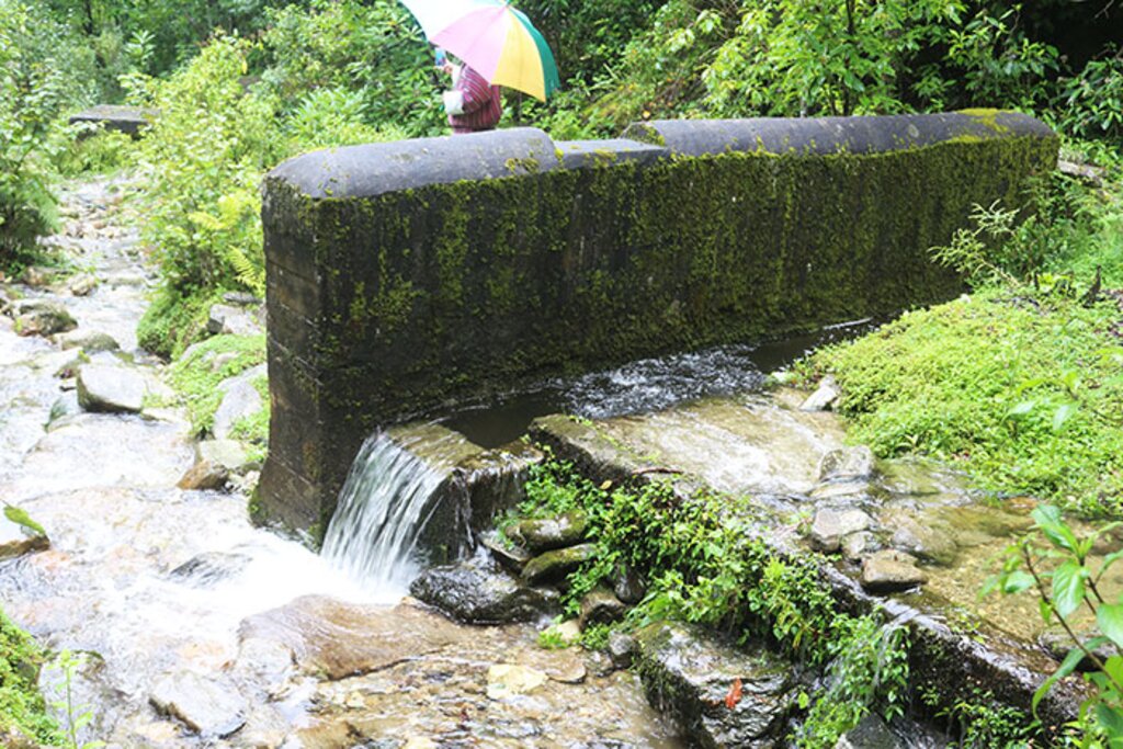
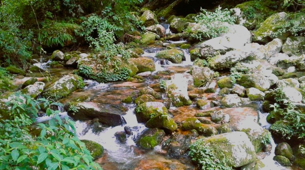
Water source protection involves protecting lakes, rivers, springs, or man-made reservoirs to avoid water pollution and damage by livestock and wild animals. In the past, the emphasis was on fencing and improving vegetation cover at the discharge point itself, but a recent focus is on groundwater recharge areas.
2.2 Description détaillée de la Technologie
Description:
Water source protection involves protecting lakes, rivers, springs or man-made reservoirs to avoid water pollution and damage by livestock and wild animals. In the past this included fencing and enhancing vegetation cover at the discharge point – that is, where the water starts flowing. However, today, water source protection also focuses on improving groundwater recharge areas. The water source protection technology has many benefits. In addition to providing a clean and regular supply of drinking and irrigation water, it also enhances the vegetation cover of the catchment area.
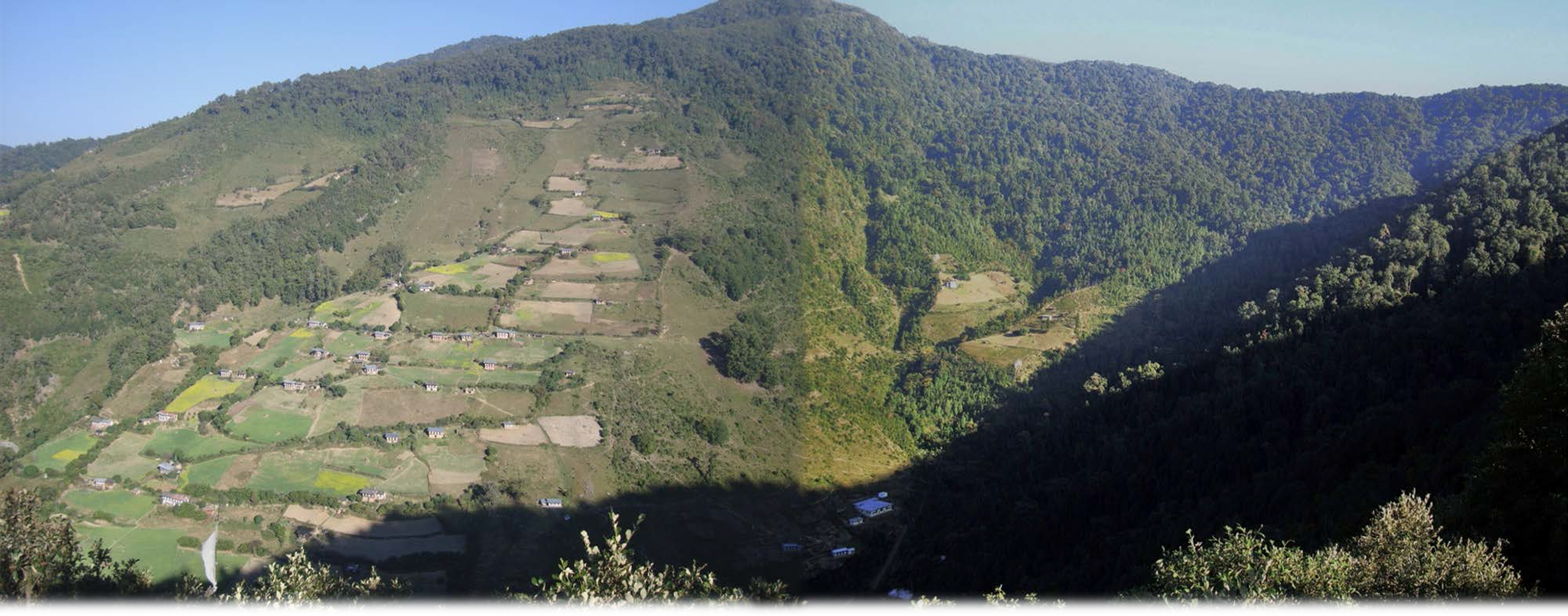
Strategies target maintaining adequate water levels in underground water reservoirs to ensure a continuous flow of streams and springs. In Yakpugang Community Forest, the technology has been applied specifically in the southern mountainous part of the village. An area of 638 acres (255 hectares) has been established as the recharge zone, and three springs have been identified for source protection. Native tree species have been planted annually in the degraded watershed to improve forest conditions. The main purpose is to protect the quality and quantity of the water for both drinking and irrigation purposes. The technology is supported by an approach that involves collective efforts of the community who realize that if their drinking and irrigation water supply is to be sustainable, they must work together.
The main purpose is to ensure a continuous supply of water for drinking and irrigation to the community. This is achieved through managing the catchment areas where rainwater soaks through the ground to reach a groundwater reservoir, and one of the key interventions is protecting the water sources from wild animals and livestock.
The water source protection technology involves 1) meeting different stakeholders, 2) signing agreements between the stakeholders, 3) site selection and survey, 4) planting of native tree species, and 5) conducting annual monitoring and evaluation. Inputs like fencing materials, planting materials, and human resources are required for the implementation and maintenance of the technology.
The technology is liked because it helps provide a continuous supply of both clean drinking and irrigation water. Furthermore, protecting water sources by the community is rewarded in monetary form by the nearby town as part of the Payment for Environmental Services (PES). This incentive helps the community to generate income which is ploughed back into the improvement and maintenance of water sources. What is disliked is the reduction in grazing land since the land users are not allowed to graze their cattle inside the water source areas.
2.3 Photos de la Technologie
2.5 Pays/ région/ lieux où la Technologie a été appliquée et qui sont couverts par cette évaluation
Pays:
Bhoutan
Région/ Etat/ Province:
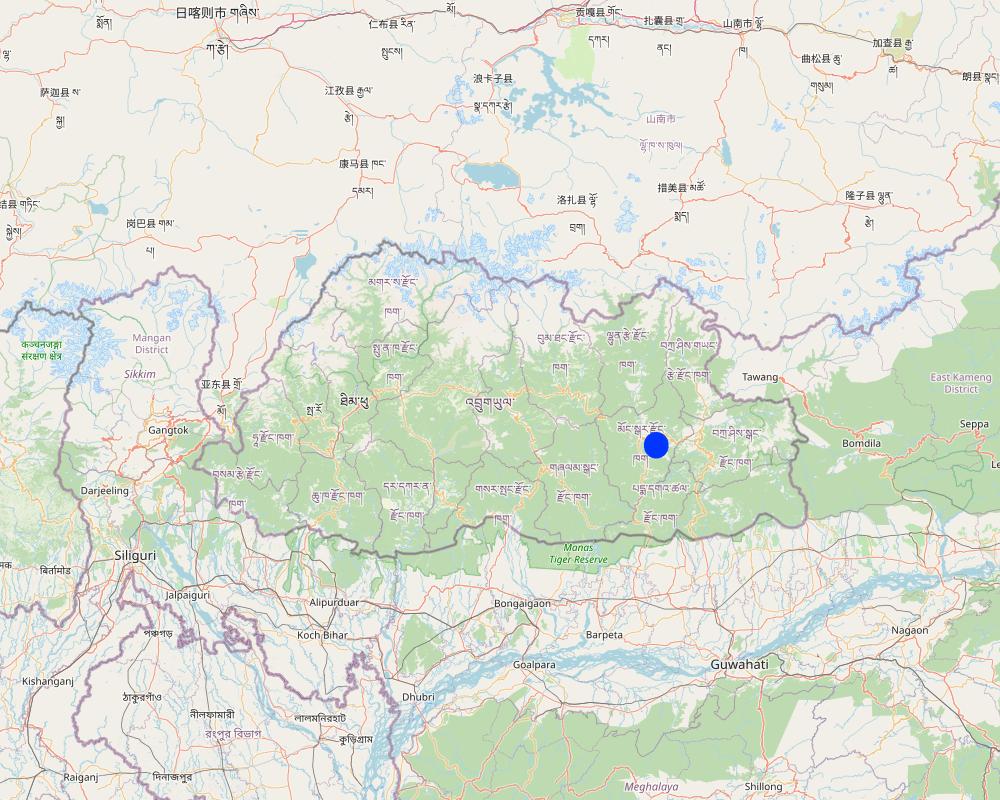
Mongar Dzongkhag (District)
Autres spécifications du lieu:
Yakpugang village
Spécifiez la diffusion de la Technologie:
- appliquée en des points spécifiques ou concentrée sur une petite surface
Est-ce que les sites dans lesquels la Technologie est appliquée sont situés dans des zones protégées en permanence?
Non
Map
×2.6 Date de mise en œuvre de la Technologie
Indiquez l'année de mise en œuvre:
2007
Si l'année précise est inconnue, indiquez la date approximative: :
- il y a moins de 10 ans (récemment)
2.7 Introduction de la Technologie
Spécifiez comment la Technologie a été introduite: :
- par le biais de projets/ d'interventions extérieures
Commentaires (type de projet, etc.) :
The project was conducted with technical assistance from SNV Bhutan and and funded through Blue Moon Funding with Watershed Management Division of the Department of Forests and Park Services. Later Mongar Regional Referral Hospital was also involved as one of the major water users.
3. Classification de la Technologie de GDT
3.1 Principal(aux) objectif(s) de la Technologie
- préserver l'écosystème
- protéger un bassin versant/ des zones situées en aval - en combinaison avec d'autres technologies
- réduire les risques de catastrophes
- s'adapter au changement et aux extrêmes climatiques et à leurs impacts
- créer un impact social positif
3.2 Type(s) actuel(s) d'utilisation des terres, là où la Technologie est appliquée
Les divers types d'utilisation des terres au sein du même unité de terrain: :
Non

Terres cultivées
- Cultures annuelles
- Plantations d’arbres ou de buissons
Cultures annuelles - Précisez les cultures:
- légumes - légumes à feuilles (laitues, choux, épinards, autres)
- légumes - légumes-racines (carotte, oignon, betterave, autres)
- Chillies
Plantations d'arbres et d'arbustes - Précisez les cultures:
- fruits à pépins (pommes, poires, coings, etc.)
- fruits à noyaux (pêche, abricot, cerise, prune)
Nombre de période de croissance par an: :
- 1
Précisez:
Vegetables are cultivated in one growing season, however, fruit trees are perennial.
Est-ce que les cultures intercalaires sont pratiquées?
Non
Est-ce que la rotation des cultures est appliquée?
Oui
Si oui, veuillez préciser:
The cole crops are rotated with root vegetables and legumes.

Voies d'eau, plans d'eau, zones humides
- Voies de drainage, voies d'eau
Principaux produits/ services:
Irrigation channels for farming and drinking water pipes
3.3 Est-ce que l’utilisation des terres a changé en raison de la mise en œuvre de la Technologie ?
Est-ce que l’utilisation des terres a changé en raison de la mise en œuvre de la Technologie ?
- Non (Passez à la question 3.4)
3.4 Approvisionnement en eau
Approvisionnement en eau des terres sur lesquelles est appliquée la Technologie:
- mixte: pluvial-irrigué
Commentaires:
The community was benefited greatly from the technology, and thus farming is mostly irrigated and rainfed is done, when rain falls in the area.
3.5 Groupe de GDT auquel appartient la Technologie
- Amélioration de la couverture végétale/ du sol
- gestion de l'irrigation (incl. l'approvisionnement en eau, le drainage)
- gestion des eaux de surface (sources, rivières, lacs, mers)
3.6 Mesures de GDT constituant la Technologie

pratiques végétales
- V1: Couverture d’arbres et d’arbustes
- V2: Herbes et plantes herbacées pérennes
3.7 Principaux types de dégradation des terres traités par la Technologie

érosion hydrique des sols
- Wt: perte de la couche superficielle des sols (couche arable)/ érosion de surface
- Wg: ravinement/ érosion en ravines

dégradation hydrique
- Ha: aridification
- Hs: changement de la quantité d’eau de surface
- Hp: baisse de la qualité des eaux de surface
3.8 Prévention, réduction de la dégradation ou réhabilitation des terres dégradées
Spécifiez l'objectif de la Technologie au regard de la dégradation des terres:
- prévenir la dégradation des terres
- réduire la dégradation des terres
4. Spécifications techniques, activités, intrants et coûts de mise en œuvre
4.1 Dessin technique de la Technologie
Spécifications techniques (associées au dessin technique):
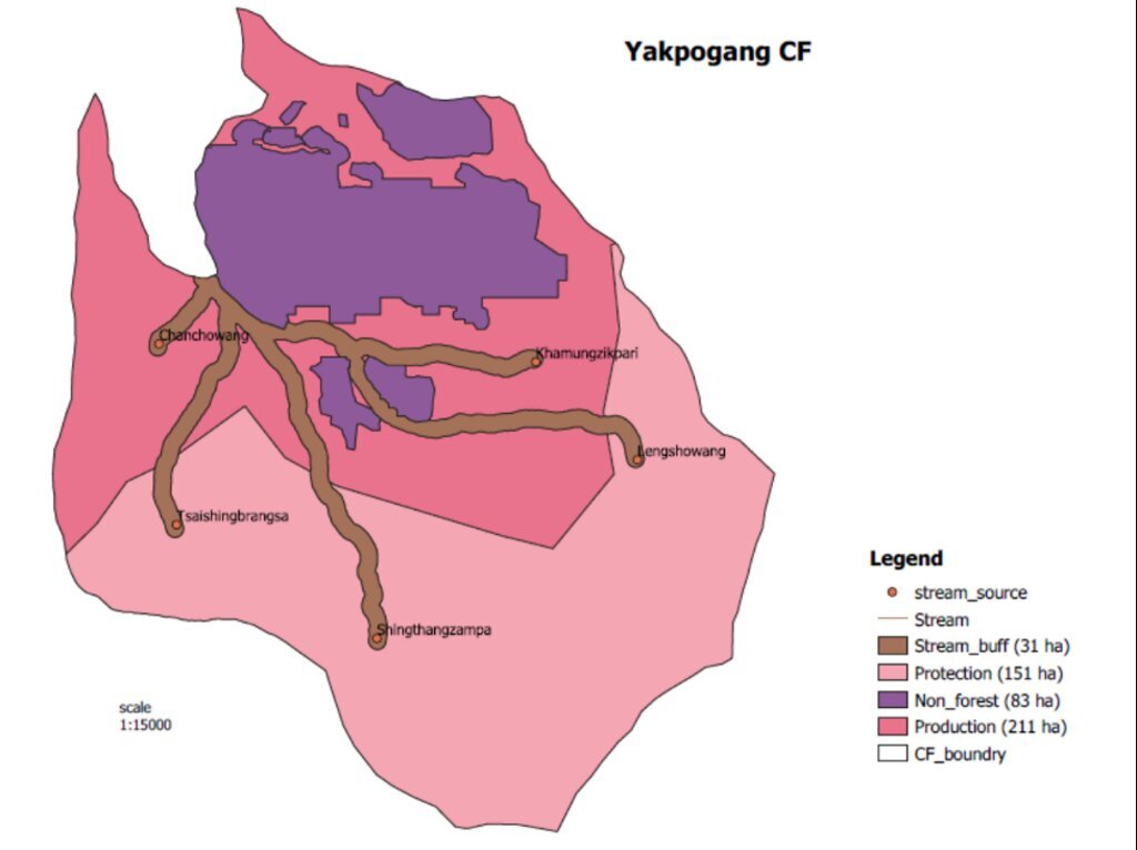
GIS map of the recharge zone of the Yakpugang spings
Yakpugang village, Mongar Gewog (Block), Mongar Dzongkhag (District), Bhutan
Auteur:
Ugyen Norten
Date:
07/10/2023
4.2 Informations générales sur le calcul des intrants et des coûts
Spécifiez la manière dont les coûts et les intrants ont été calculés:
- par entité de la Technologie
Précisez l'unité:
Recharge zone of 638 acres (255 hectares)
Précisez les dimensions de l'unité de terrain (le cas échéant):
638 acres (255 hectares)
Indiquez le taux de change des USD en devise locale, le cas échéant (p.ex. 1 USD = 79.9 réal brésilien): 1 USD = :
82,08
Indiquez le coût salarial moyen de la main d'œuvre par jour:
1000
4.3 Activités de mise en place/ d'établissement
| Activité | Calendrier des activités (saisonnier) | |
|---|---|---|
| 1. | Community meeting | Conducted several times |
| 2. | Survey of the recharge zone and site selection | The survey took around 2 to 3 weeks |
| 3. | Agreement between the stakeholders | Agreement done thrice |
| 4. | Native tree species plantation around the watershed | Based on a specified date and each individuals from household came |
Commentaires:
The establishment activities were done with the technical assistance from SNV Bhutan and the Department of Forests and Park Services since the water source falls under the community forest.
4.4 Coûts et intrants nécessaires à la mise en place
Si vous n'êtes pas en mesure de décomposer les coûts dans le tableau précédent, donnez une estimation du coût total de la mise en place de la Technologie:
258500,0
Si le coût n'est pas pris en charge à 100% par l'exploitant des terres, indiquez qui a financé le coût restant:
The project was funded through Blue Moon in collaboration with Watershed Management Division of the Department of Forests and Park Services and Global Environment Facility (GEF) was also involved.
4.5 Activités d'entretien/ récurrentes
| Activité | Calendrier/ fréquence | |
|---|---|---|
| 1. | Clearing of the water source | Thrice annually |
4.6 Coûts et intrants nécessaires aux activités d'entretien/ récurrentes (par an)
| Spécifiez les intrants | Unité | Quantité | Coûts par unité | Coût total par intrant | % des coût supporté par les exploitants des terres | |
|---|---|---|---|---|---|---|
| Main d'œuvre | Community Forest members | person/day. | 102,0 |
Commentaires:
Since the water source is a community asset, an individual from each household goes to the water source area for annual maintenance. This happens three times a year, and no cost goes into it except labour contribution from each household during which they bring their own tools and food.
4.7 Facteurs les plus importants affectant les coûts
Décrivez les facteurs les plus importants affectant les coûts :
None.
5. Environnement naturel et humain
5.1 Climat
Précipitations annuelles
- < 250 mm
- 251-500 mm
- 501-750 mm
- 751-1000 mm
- 1001-1500 mm
- 1501-2000 mm
- 2001-3000 mm
- 3001-4000 mm
- > 4000 mm
Spécifications/ commentaires sur les précipitations:
The data was used from the nearest weather station of the National Center for Hydrology and Meteorology (NCHM).
Indiquez le nom de la station météorologique de référence considérée:
https://www.nchm.gov.bt/home/pageMenu/906
Zone agro-climatique
- subhumide
Warm temperate zone
5.2 Topographie
Pentes moyennes:
- plat (0-2 %)
- faible (3-5%)
- modéré (6-10%)
- onduleux (11-15%)
- vallonné (16-30%)
- raide (31-60%)
- très raide (>60%)
Reliefs:
- plateaux/ plaines
- crêtes
- flancs/ pentes de montagne
- flancs/ pentes de colline
- piémonts/ glacis (bas de pente)
- fonds de vallée/bas-fonds
Zones altitudinales:
- 0-100 m
- 101-500 m
- 501-1000 m
- 1001-1500 m
- 1501-2000 m
- 2001-2500 m
- 2501-3000 m
- 3001-4000 m
- > 4000 m
Indiquez si la Technologie est spécifiquement appliquée dans des:
- situations concaves
5.3 Sols
Profondeur moyenne du sol:
- très superficiel (0-20 cm)
- superficiel (21-50 cm)
- modérément profond (51-80 cm)
- profond (81-120 cm)
- très profond (>120 cm)
Texture du sol (de la couche arable):
- moyen (limoneux)
Matière organique de la couche arable:
- abondant (>3%)
5.4 Disponibilité et qualité de l'eau
Disponibilité de l’eau de surface:
bonne
Qualité de l’eau (non traitée):
eau potable
La qualité de l'eau fait référence à:
eaux de surface
La zone est-elle inondée?
Non
Commentaires et précisions supplémentaires sur la qualité et la quantité d'eau:
Water quantity and quality have been greatly improved with the intervention of water source protection. These three water sources provide drinking water to Mongar town and Mongar hospital.
5.5 Biodiversité
Diversité des espèces:
- élevé
Diversité des habitats:
- élevé
5.6 Caractéristiques des exploitants des terres appliquant la Technologie
Sédentaire ou nomade:
- Sédentaire
Orientation du système de production:
- exploitation mixte (de subsistance/ commerciale)
Revenus hors exploitation:
- > 50% de tous les revenus
Niveau relatif de richesse:
- moyen
Individus ou groupes:
- individu/ ménage
Niveau de mécanisation:
- mécanisé/ motorisé
Genre:
- femmes
- hommes
Age des exploitants des terres:
- personnes d'âge moyen
5.7 Superficie moyenne des terres utilisées par les exploitants des terres appliquant la Technologie
- < 0,5 ha
- 0,5-1 ha
- 1-2 ha
- 2-5 ha
- 5-15 ha
- 15-50 ha
- 50-100 ha
- 100-500 ha
- 500-1 000 ha
- 1 000-10 000 ha
- > 10 000 ha
Cette superficie est-elle considérée comme de petite, moyenne ou grande dimension (en se référant au contexte local)?
- petite dimension
Commentaires:
Total land is 1.5 acres and total cultivated and is 1 acre
5.8 Propriété foncière, droits d’utilisation des terres et de l'eau
Propriété foncière:
- individu, avec titre de propriété
Droits d’utilisation des terres:
- individuel
Droits d’utilisation de l’eau:
- communautaire (organisé)
Est-ce que les droits d'utilisation des terres sont fondés sur un système juridique traditionnel?
Oui
Précisez:
The traditional legal system in our country is as per the Land Act and Land Rules and Regulations which dictate the land use in the country.
5.9 Accès aux services et aux infrastructures
santé:
- pauvre
- modéré
- bonne
éducation:
- pauvre
- modéré
- bonne
assistance technique:
- pauvre
- modéré
- bonne
emploi (par ex. hors exploitation):
- pauvre
- modéré
- bonne
marchés:
- pauvre
- modéré
- bonne
énergie:
- pauvre
- modéré
- bonne
routes et transports:
- pauvre
- modéré
- bonne
eau potable et assainissement:
- pauvre
- modéré
- bonne
services financiers:
- pauvre
- modéré
- bonne
6. Impacts et conclusions
6.1 Impacts sur site que la Technologie a montrés
Impacts socio-économiques
Production
production agricole
Quantité avant la GDT:
15 baskets of maize
Quantité après la GDT:
20 to 25 baskets maize
Commentaires/ spécifiez:
There has been an increase in the amount of maize, which has been credited to the increase in the amount of water than in the past.
qualité des cultures
Commentaires/ spécifiez:
According to the land user, crop quality has been relatively better after the implementation of the technology than in the past.
risque d'échec de la production
Commentaires/ spécifiez:
Due to the presence of water in the community, production has decreased.
diversité des produits
Quantité avant la GDT:
maize and some other cereals and vegetables were grown
Quantité après la GDT:
maize together with cole crops, tubers and fruits are grown
surface de production
Quantité avant la GDT:
1 acres
Quantité après la GDT:
1.5 acres
Commentaires/ spécifiez:
In the past, the lack of water would lead the land users to keeping some of the land fallow.
Disponibilité et qualité de l'eau
disponibilité de l'eau potable
Quantité avant la GDT:
Water would be scarce periodically
Quantité après la GDT:
Water is now available throughout the community
Commentaires/ spécifiez:
Drinking water availability has increased compared to the past. This is mainly due to the protection of water sources. In addition, now community members also go for regular clearing of irrigation channels, drinking water pipelines, and sources to keep the supply steady.
qualité de l'eau potable
Commentaires/ spécifiez:
Quality in terms of cleanliness of drinking water was reported to have enhanced because in the past nearby streams from where they get their drinking water used to get polluted by rainwater, animals, etc.
disponibilité de l'eau pour l'élevage
Quantité avant la GDT:
Water would be taken to the nearby streams
Quantité après la GDT:
Water is now provided near there house
Commentaires/ spécifiez:
Since supply is continuous the water availability for livestock also increased.
qualité de l'eau pour l'élevage
Commentaires/ spécifiez:
Water for livestock are also improved than in the past.
disponibilité de l'eau d'irrigation
Quantité avant la GDT:
Focused more on growing crops requiring less water
Quantité après la GDT:
Now grows variety of diverse crops
Commentaires/ spécifiez:
Since the water flow is continuous, there is enough water to carry out multiple cropping.
qualité de l'eau d'irrigation
Commentaires/ spécifiez:
Water quality for irrigation is better than the past
Revenus et coûts
revenus agricoles
Quantité avant la GDT:
focuses mostly on commercialising maize
Quantité après la GDT:
now commercialises diverse vegetable crops as well
Impacts socioculturels
sécurité alimentaire/ autosuffisance
Commentaires/ spécifiez:
The availability of water in the community, allowed for the land users to grow a diverse vegetable crops in large amount.
situation sanitaire
Quantité avant la GDT:
Community members prone to water related disease
Quantité après la GDT:
Water is relatively cleaner
droits d'utilisation des terres/ de l'eau
Commentaires/ spécifiez:
Agreement for water source protection is conducted after every end of the agreement year, where water use rights are also discussed.
Impacts écologiques
Cycle de l'eau/ ruissellement
quantité d'eau
Quantité avant la GDT:
water from the source would dry up most of the times
Quantité après la GDT:
water in the water source is almost always filled.
qualité de l'eau
Quantité avant la GDT:
Would be dirty due to wild animals and grazing cattle
Quantité après la GDT:
Since water source is protected, water is relatively cleaner
Réduction des risques de catastrophe et des risques climatiques
impacts de la sécheresse
Quantité avant la GDT:
in the past, drought would occur periodically
Quantité après la GDT:
Even during the absence of rain, water is still available
6.2 Impacts hors site que la Technologie a montrés
pollution des rivières/ nappes phréatiques
Quantité avant la GDT:
Would normally be polluted due to wild animals and grazing cattles
Quantité après la GDT:
Water is now clean and also drinkable
6.3 Exposition et sensibilité de la Technologie aux changements progressifs et aux évènements extrêmes/catastrophes liés au climat (telles que perçues par les exploitants des terres)
Changements climatiques progressifs
Changements climatiques progressifs
| Saison | Augmentation ou diminution | Comment la Technologie fait-elle face à cela? | |
|---|---|---|---|
| températures annuelles | augmente | modérément | |
| précipitations annuelles | augmente | modérément |
Extrêmes climatiques (catastrophes)
Catastrophes météorologiques
| Comment la Technologie fait-elle face à cela? | |
|---|---|
| pluie torrentielle locale | modérément |
| orage local | très bien |
| averse de grêle locale | bien |
| tempête de vent locale | bien |
Catastrophes climatiques
| Comment la Technologie fait-elle face à cela? | |
|---|---|
| sécheresse | bien |
| feu de forêt | pas bien |
| feu de végétation | pas bien |
Catastrophes hydrologiques
| Comment la Technologie fait-elle face à cela? | |
|---|---|
| inondation générale (rivière) | pas bien |
| crue éclair | pas bien |
| glissement de terrain | pas bien du tout |
6.4 Analyse coûts-bénéfices
Quels sont les bénéfices comparativement aux coûts de mise en place (du point de vue des exploitants des terres)?
Rentabilité à court terme:
positive
Rentabilité à long terme:
positive
Quels sont les bénéfices comparativement aux coûts d'entretien récurrents (du point de vue des exploitants des terres)?
Rentabilité à court terme:
positive
Rentabilité à long terme:
positive
Commentaires:
The income earned from the project goes into community development and the community forest, and the expense for the project is already funded.
6.5 Adoption de la Technologie
- > 50%
Si disponible, quantifiez (nombre de ménages et/ou superficie couverte):
102 households
De tous ceux qui ont adopté la Technologie, combien d'entre eux l'ont fait spontanément, à savoir sans recevoir aucune incitation matérielle, ou aucune rémunération? :
- 0-10%
6.6 Adaptation
La Technologie a-t-elle été récemment modifiée pour s'adapter à l'évolution des conditions?
Non
6.7 Points forts/ avantages/ possibilités de la Technologie
| Points forts/ avantages/ possibilités du point de vue de l'exploitant des terres |
|---|
| Continuous supply of both drinking water and irrigation water |
| Water is supplied to Mongar town, and income is earned from it under Payment for Environmental Services (PES) arrangement b |
| Has helped in community development and improvement of community forest |
| Points forts/ avantages/ possibilités du point de vue du compilateur ou d'une autre personne ressource clé |
|---|
| Water quality is preserved, and pollution and contamination of the water sources are prevented. |
| The plantation of native tree species helps conserve the ecosystem. |
| Long-term sustainability and enhanced climate resilience of the water source |
6.8 Faiblesses/ inconvénients/ risques de la Technologie et moyens de les surmonter
| Faiblesses/ inconvénients/ risques du point de vue de l’exploitant des terres | Comment peuvent-ils être surmontés? |
|---|---|
| Decreased grazing land | Shift the grazing area outside the community forest or establish improved pasture land in their registered land |
7. Références et liens
7.1 Méthodes/ sources d'information
- visites de terrain, enquêtes sur le terrain
One household
- interviews/entretiens avec les exploitants des terres
One individual
Quand les données ont-elles été compilées (sur le terrain)?
11/07/2023
7.2 Références des publications disponibles
Titre, auteur, année, ISBN:
Norten, U. (2021). Impact of Water Management strategies- Payment for Ecosystem Services (PES) in Bhutan. International Journal of Science and Innovative Research, 2(8), 109-144.
Disponible à partir d'où? Coût?
https://ijesir.org/wp-content/uploads/2021/11/0100072IJESIRnew.pdf
Titre, auteur, année, ISBN:
WWF. (2017). Valuing Ecosystem Services in Chamkharchhu Sub Basin: Mapping Sediment Using InVEST. WWF.
Disponible à partir d'où? Coût?
https://wwfasia.awsassets.panda.org/downloads/final_invest_report_final_draft_may_17_spread_compressed_2.pdf
7.3 Liens vers les informations pertinentes en ligne
Titre/ description:
Source Water Protection
URL:
https://www.nrcs.usda.gov/programs-initiatives/source-water-protection
Titre/ description:
Water Source Protection
URL:
https://sswm.info/arctic-wash/module-4-technology/further-resources-water-sources/water-source-protection
Titre/ description:
Basic Information about Source Water Protection
URL:
https://www.epa.gov/sourcewaterprotection/basic-information-about-source-water-protection
Titre/ description:
Conserving water resources with PES, an example from Yakpugang
URL:
https://kuenselonline.com/conserving-water-resources-with-pes-an-example-from-yakpugang/
Liens et modules
Développer tout Réduire toutLiens
Aucun lien
Modules
Aucun module trouvé


