Water Source Protection [ບູຕານ]
- ການສ້າງ:
- ປັບປູງ:
- ຜູ້ສັງລວມຂໍ້ມູນ: ONGPO LEPCHA
- ບັນນາທິການ: Haka Drukpa
- ຜູ້ທົບທວນຄືນ: William Critchley, Rima Mekdaschi Studer
Chhu Ka Soongchop (ཆུ་བརྐ་སྲུང་སྐྱོབ།)
technologies_6842 - ບູຕານ
ເບິ່ງພາກສ່ວນ
ຂະຫຍາຍທັງໝົດ ຍຸບທັງໝົດ1. ຂໍ້ມູນທົ່ວໄປ
1.2 ຂໍ້ມູນ ການຕິດຕໍ່ພົວພັນ ຂອງບຸກຄົນທີ່ສໍາຄັນ ແລະ ສະຖາບັນ ທີ່ມີສ່ວນຮ່ວມ ໃນການປະເມີນເອກກະສານ ເຕັກໂນໂລຢີ
ບັນດາຜູ້ຕອບແບບສອບຖາມທີ່ສໍາຄັນ ()
ຜູ້ນໍາໃຊ້ທີ່ດິນ:
Dorji Sangay
Yakpugang Community
ບູຕານ
ຊື່ໂຄງການ ທີ່ອໍານວຍຄວາມສະດວກ ໃນການສ້າງເອກກະສານ/ປະເມີນ ເຕັກໂນໂລຢີ (ຖ້າກ່ຽວຂ້ອງ)
Strengthening national-level institutional and professional capacities of country Parties towards enhanced UNCCD monitoring and reporting – GEF 7 EA Umbrella II (GEF 7 UNCCD Enabling Activities_Umbrella II)ຊື່ສະຖາບັນ (ຫຼາຍສະຖາບັນ) ທີ່ອໍານວຍຄວາມສະດວກ ໃນການສ້າງເອກກະສານ / ປະເມີນ ເຕັກໂນໂລຢີ (ຖ້າກ່ຽວຂ້ອງ)
National Soil Services Centre, Department of Agriculture, Ministry of Agriculture & Livestock (NSSC) - ບູຕານ1.3 ເງື່ອນໄຂ ກ່ຽວກັບ ການນໍາໃຊ້ຂໍ້ມູນເອກະສານ ທີ່ສ້າງຂື້ນ ໂດຍຜ່ານ ອົງການພາບລວມຂອງໂລກ ທາງດ້ານແນວທາງ ແລະ ເຕັກໂນໂລຢີ ຂອງການອານຸລັກ ທໍາມະຊາດ (WOCAT)
ຜູ້ປ້ອນຂໍ້ມູນ ແລະ ບຸກຄົນສຳຄັນ ທີ່ໃຫ້ຂໍ້ມູນ (ຫຼາຍ) ຍິນຍອມ ຕາມເງື່ອນໄຂ ໃນການນຳໃຊ້ຂໍ້ມູນ ເພື່ອສ້າງເປັນເອກກະສານຂອງ WOCAT:
ແມ່ນ
1.4 ແຈ້ງການວ່າ ດ້ວຍຄວາມຍືນຍົງຂອງ ເຕັກໂນໂລຢີ
ການນໍາໃຊ້ ເຕັກໂນໂລຢີ ດັ່ງກ່າວໄດ້ອະທິບາຍ ເຖິງບັນຫາ ກ່ຽວກັບ ການເຊື່ອມໂຊມຂອງດິນບໍ? ຖ້າບໍ່ດັ່ງນັ້ນ ມັນບໍ່ສາມາດ ຢັ້ງຢືນໄດ້ວ່າ ເປັນເຕັກໂນໂລຊີ ໃນການຄຸ້ມຄອງ ທີ່ດິນແບບຍືນຍົງ? :
ບໍ່ແມ່ນ
2. ການອະທິບາຍ ເຕັກໂນໂລຢີ ຂອງການຄຸ້ມຄອງ ທີ່ດິນແບບຍືນຍົງ
2.1 ຄໍາອະທິບາຍສັ້ນຂອງ ເຕັກໂນໂລຢີ
ການກຳໜົດຄວາມໝາຍ ຂອງເຕັກໂນໂລຢີ:
Water source protection involves protecting lakes, rivers, springs, or man-made reservoirs to avoid water pollution and damage by livestock and wild animals. In the past, the emphasis was on fencing and improving vegetation cover at the discharge point itself, but a recent focus is on groundwater recharge areas.
2.2 ການອະທິບາຍ ລາຍລະອຽດ ຂອງເຕັກໂນໂລຢີ
ການພັນລະນາ:
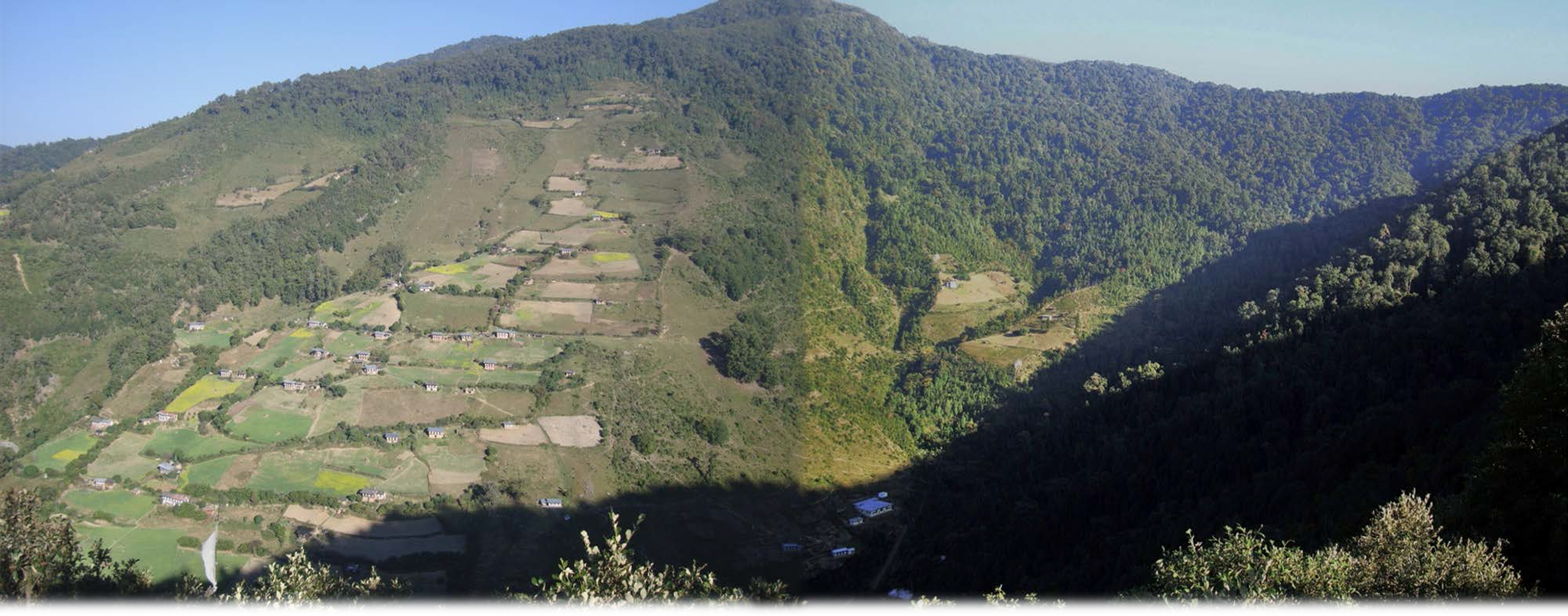
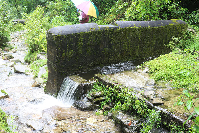
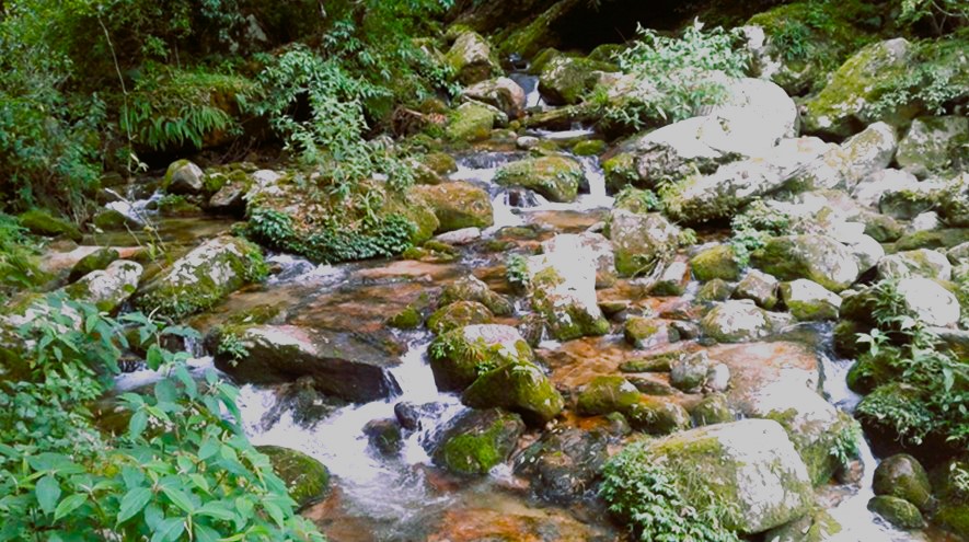
Water source protection involves protecting lakes, rivers, springs or man-made reservoirs to avoid water pollution and damage by livestock and wild animals. In the past this included fencing and enhancing vegetation cover at the discharge point – that is, where the water starts flowing. However, today, water source protection also focuses on improving groundwater recharge areas. The water source protection technology has many benefits. In addition to providing a clean and regular supply of drinking and irrigation water, it also enhances the vegetation cover of the catchment area.
Strategies target maintaining adequate water levels in underground water reservoirs to ensure a continuous flow of streams and springs. In Yakpugang Community Forest, the technology has been applied specifically in the southern mountainous part of the village. An area of 638 acres (255 hectares) has been established as the recharge zone, and three springs have been identified for source protection. Native tree species have been planted annually in the degraded watershed to improve forest conditions. The main purpose is to protect the quality and quantity of the water for both drinking and irrigation purposes. The technology is supported by an approach that involves collective efforts of the community who realize that if their drinking and irrigation water supply is to be sustainable, they must work together.
The main purpose is to ensure a continuous supply of water for drinking and irrigation to the community. This is achieved through managing the catchment areas where rainwater soaks through the ground to reach a groundwater reservoir, and one of the key interventions is protecting the water sources from wild animals and livestock.
The water source protection technology involves 1) meeting different stakeholders, 2) signing agreements between the stakeholders, 3) site selection and survey, 4) planting of native tree species, and 5) conducting annual monitoring and evaluation. Inputs like fencing materials, planting materials, and human resources are required for the implementation and maintenance of the technology.
The technology is liked because it helps provide a continuous supply of both clean drinking and irrigation water. Furthermore, protecting water sources by the community is rewarded in monetary form by the nearby town as part of the Payment for Environmental Services (PES). This incentive helps the community to generate income which is ploughed back into the improvement and maintenance of water sources. What is disliked is the reduction in grazing land since the land users are not allowed to graze their cattle inside the water source areas.
2.3 ຮູບພາບຂອງເຕັກໂນໂລຢີ
ສື່ຮູບພາບ
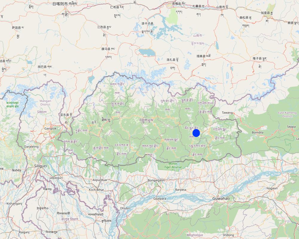
2.5 ປະເທດ / ເຂດ / ສະຖານທີ່ບ່ອນທີ່ ເຕັກໂນໂລຢີ ໄດ້ຮັບການນໍາໃຊ້ ແລະ ທີ່ຖືກປົກຄຸມດ້ວຍການປະເມີນຜົນ
ປະເທດ:
ບູຕານ
ພາກພື້ນ / ລັດ / ແຂວງ:
Mongar Dzongkhag (District)
ຂໍ້ມູນເພີ່ມເຕີມຂອງສະຖານທີ່:
Yakpugang village
ໃຫ້ລະບຸ ການແຜ່ຂະຫຍາຍ ເຕັກໂນໂລຢີ:
- ນໍາໃຊ້ໃນຈຸດສະເພາະ / ແນໃສ່ນໍາໃຊ້ໃນພື້ນທີ່ຂະໜາດນ້ອຍ
ສ່ວນຫຼາຍສະຖານທີ່ຕັ້ງຂອງເຕັກໂນໂລຢີ ແມ່ນ ຢູ່ໃນເຂດພື້ນທີ່ສະຫງວນບໍ?
ບໍ່ແມ່ນ
Map
×2.6 ວັນທີໃນການຈັດຕັ້ງປະຕິບັດ
ໃຫ້ລະບຸປີ ໃນການຈັດຕັ້ງປະຕິບັດ:
2007
ຖ້າຫາກວ່າ ບໍ່ຮູ້ຈັກ ປີທີ່ຊັດເຈນ ແມ່ນໃຫ້ປະມານ ວັນທີເອົາ:
- ຕໍ່າກວ່າ 10 ປີ ຜ່ານມາ (ມາເຖິງປະຈຸບັນ)
2.7 ການນໍາສະເໜີ ເຕັກໂນໂລຢີ
ໃຫ້ລະບຸ ເຕັກໂນໂລຢີ ໄດ້ຖືກຈັດຕັ້ງປະຕິບັດຄືແນວໃດ?
- ໂດຍຜ່ານໂຄງການ / ການຊ່ວຍເຫຼືອຈາກພາຍນອກ
ຄວາມຄິດເຫັນ (ປະເພດ ໂຄງການ ແລະ ອື່ນໆ):
The project was conducted with technical assistance from SNV Bhutan and and funded through Blue Moon Funding with Watershed Management Division of the Department of Forests and Park Services. Later Mongar Regional Referral Hospital was also involved as one of the major water users.
3. ການໃຈ້ແຍກ ເຕັກໂນໂລຢີ ໃນການຄຸ້ມຄອງ ດິນແບບຍືນຍົງ
3.1 ຈຸດປະສົງຫຼັກ (ຫຼາຍ) ຂອງເຕັກໂນໂລຢີ
- ການອະນຸລັກ ລະບົບນິເວດ
- ປົກປັກຮັກສານໍ້າ / ນໍ້າພື້ນທີ່ - ປະສົມປະສານກັບ ເຕັກໂນໂລຢີອື່ນໆ
- ຫຼຸດຜ່ອນຄວາມສ່ຽງ ທາງໄພພິບັດທໍາມະຊາດ
- ປັບຕົວຕໍ່ກັບການປ່ຽນແປງດິນຟ້າອາກາດ / ທີ່ຮ້າຍແຮງ ແລະ ຜົນກະທົບ
- ສ້າງຜົນກະທົບ ທີ່ເປັນທາງບວກ ໃຫ້ແກ່ສັງຄົມ
3.2 ປະເພດການນໍາໃຊ້ທີ່ດິນ ໃນປະຈຸບັນ() ທີ່ເຕັກໂນໂລຢີ ໄດ້ຖືກນໍາໃຊ້
ການນຳໃຊ້ທີ່ດິນ ປະສົມພາຍໃນພື້ນທີ່ດຽວກັນ:
ບໍ່ແມ່ນ

ດິນທີ່ປູກພືດ
- ການປູກພືດປະຈໍາປີ
- ເປັນໄມ້ຢືນຕົ້ນ ແລະ ໄມ້ພຸ່ມ ຈາກການປູກພືດ
ການປູກພືດປະຈຳປີ - ລະບຸປະເພດພືດ:
- ຜັກ-ຜັກໃບ( ຜັກສະລັດ, ຜັກກະລຳ, ຜັກຫົມ, ອື່ນໆ)
- ຜັກ-ຜັກໃຫ້ຫົົວ ( ກາລົດ, ຜັກບົ່ວຫົວໃຫ່ຍ, ຜັກກາດຫວານ, ອື່ນໆ)
- Chillies
ການປູກພືດທີ່ເປັນຕົ້ນໄມ້ ແລະ ໄມ້ພຸ່ມ - ລະບຸປະເພດພືດ:
- ຫມາກໄມ້ນ້ອຍ (ຫມາກໂປມ, ໝາກຊາລີ, ໝາກຈອງ, ແລະອື່ນໆ)
- stone fruits (peach, apricot, cherry, plum, etc)
ຈໍານວນ ລະດູການ ປູກໃນປີໜຶ່ງ:
- 1
ລະບຸ ຊະນິດ:
Vegetables are cultivated in one growing season, however, fruit trees are perennial.
ມີການເຝືກປູກພືດແບບສັບຫວ່າງບໍ່?
ບໍ່ແມ່ນ
ມີການເຝືກປູກພືດແບບໝູນວຽນບໍ່?
ແມ່ນ
ຖ້າແມ່ນ, ໃຫ້ລະບຸແຈ້ງ:
The cole crops are rotated with root vegetables and legumes.

ທິດທາງໄຫຼຂອງນໍ້າ, ນໍ້າ, ດິນທາມ
- ທໍ່ລະບາຍນໍ້າ, ທິດທາງນໍ້າ
ຜະລິດຕະພັນຫຼັກ / ບໍລິການ:
Irrigation channels for farming and drinking water pipes
3.3 ການນຳໃຊ້ທີ່ດິນ ມີການປ່ຽນແປງຍ້ອນການຈັດຕັ້ງທົດລອງເຕັກໂນໂລຢີ ແມ່ນບໍ່?
ການນຳໃຊ້ທີ່ດິນ ມີການປ່ຽນແປງຍ້ອນການຈັດຕັ້ງທົດລອງເຕັກໂນໂລຢີ ແມ່ນບໍ່?
- ບໍ່ (ຕໍ່ເໜືອງກັບ ຄຳຖາມ 3.4)
3.4 ການສະໜອງນ້ຳ
ການສະໜອງນໍ້າ ໃນພື້ນທີ່ ທີ່ໄດ້ນໍາໃຊ້ ເຕັກໂນໂລຢີ:
- ປະສົມປະສານ ກັນລະຫວ່າງ ນໍ້າຝົນ ແລະ ນໍ້າຊົນລະປະທານ
ຄວາມຄິດເຫັນ:
The community was benefited greatly from the technology, and thus farming is mostly irrigated and rainfed is done, when rain falls in the area.
3.5 ການນໍາໃຊ້ເຕັກໂນໂລຢີ ທີ່ຢູ່ໃນກຸ່ມການຄຸ້ມຄອງ ທີ່ດິນແບບຍືນຍົງ
- ການປັບປຸງດິນ / ພືດຄຸມດິນ
- ການຄຸ້ມຄອງຊົນລະປະທານ (ການສະໜອງນໍ້າ, ລະບາຍ)
- ການຄຸ້ມຄອງນໍ້າໜ້າດິນ (ນ້ຳຈາກພຸ, ແມ່ນໍ້າ, ທະເລສາບ, ທະເລ)
3.6 ມາດຕະການ ການຄຸ້ມຄອງ ທີ່ດິນແບບຍືນຍົງ ປະກອບດ້ວຍ ເຕັກໂນໂລຢີ

ມາດຕະການ ທາງດ້ານພືດພັນ
- V1: ເປັນໄມ້ຢືນຕົ້ນ ແລະ ການປົກຫຸ້ມຂອງໄມ້ພຸ່ມ
- V2: ຫຍ້າ ແລະ ພືດສະໝູນໄພທີ່ເປັນໄມ້ຢືນຕົ້ນ
3.7 ປະເພດດິນເຊື່ອມໂຊມ ຫຼັກທີ່ໄດ້ນໍາໃຊ້ ເຕັກໂນໂລຢີ

ດິນເຊາະເຈື່ອນ ໂດຍນໍ້າ
- Wt: ການສູນເສຍຊັ້ນໜ້າດິນ / ການເຊາະເຈື່ອນຜິວໜ້າດິນ
- Wg: ການເຊາະເຈື່ອນຮ່ອງນ້ຳ / ຫ້ວຍ

ການເຊື່ອມໂຊມ ຂອງນໍ້າ
- Ha: ສະພາບແຫ້ງແລ້ງ
- Hs: ການປ່ຽນແປງ ປະລິມານ ນໍ້າໜ້າດິນ
- Hp: ຄຸນນະພາບ ຂອງນ້ຳຊັ້ນໜ້າດິນຫຼຸດລົງ
3.8 ການປ້ອງກັນ, ການຫຼຸດຜ່ອນ, ຫຼືການຟື້ນຟູຂອງການເຊື່ອມໂຊມຂອງດິນ
ໃຫ້ລະບຸ ເປົ້າໝາຍ ເຕັກໂນໂລຢີ ທີ່ພົວພັນ ກັບຄວາມເຊື່ອມໂຊມຂອງດິນ:
- ປ້ອງກັນການເຊື່ອມໂຊມຂອງດິນ
- ຫຼຸດຜ່ອນການເຊື່ອມໂຊມຂອງດິນ
4. ຂໍ້ກໍາໜົດ, ກິດຈະກໍາການປະຕິບັດ, ວັດຖຸດິບ, ແລະຄ່າໃຊ້ຈ່າຍ
4.1 ເຕັກນິກ ໃນການແຕ້ມແຜນວາດ ເຕັກໂນໂລຢີ
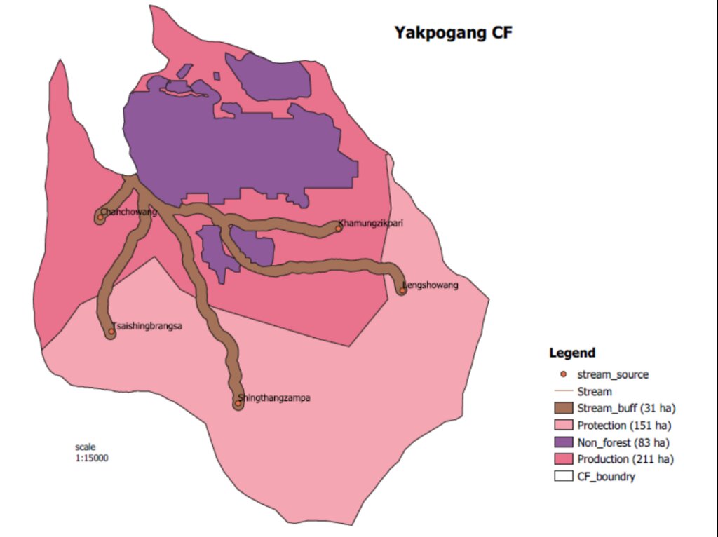
ຄຸນລັກສະນະ ຂອງເຕັກນິກ (ທີ່ກ່ຽວຂ້ອງ ກັບການແຕ້ມແຜນວາດ ທາງດ້ານເຕັກນີກ):
GIS map of the recharge zone of the Yakpugang spings
Yakpugang village, Mongar Gewog (Block), Mongar Dzongkhag (District), Bhutan
ຜູ້ຂຽນ:
Ugyen Norten
ວັນທີ:
07/10/2023
4.2 ຂໍ້ມູນທົ່ວໄປກ່ຽວກັບການຄິດໄລ່ປັດໃຈຂາເຂົ້າໃນການຜະລິດ ແລະ ມູນຄ່າອື່ນໆ
ລະບຸ ວິທີການ ຄຳໃຊ້ຈ່າຍ ແລະ ປັດໄຈນໍາເຂົ້າ ທີ່ໄດ້ຄິດໄລ່:
- ຕໍ່ຫົວໜ່ວຍ ທີ່ໄດ້ຈັດຕັ້ງປະຕິບັດ ເຕັກໂນໂລຢີ
ໃຫ້ລະບຸຫົວໜ່ວຍ:
Recharge zone of 638 acres (255 hectares)
ກໍານົດຂະຫນາດຂອງຫົວນ໋ວຍ (ຖ້າກ່ຽວຂ້ອງ):
638 acres (255 hectares)
ຖ້າກ່ຽວຂ້ອງ, ໃຫ້ລະບຸອັດຕາແລກປ່ຽນຈາກ USD ເປັນສະກຸນເງິນທ້ອງຖິ່ນ (ເຊັ່ນ: 1 USD = 79.9 Brazilian Real): 1 USD =:
82.08
ລະບຸ ຄ່າຈ້າງ ຄ່າແຮງງານສະເລ່ຍ ຕໍ່ ວັນ:
1000
4.3 ການສ້າງຕັ້ງກິດຈະກໍາ
| ກິດຈະກໍາ | Timing (season) | |
|---|---|---|
| 1. | Community meeting | Conducted several times |
| 2. | Survey of the recharge zone and site selection | The survey took around 2 to 3 weeks |
| 3. | Agreement between the stakeholders | Agreement done thrice |
| 4. | Native tree species plantation around the watershed | Based on a specified date and each individuals from household came |
ຄວາມຄິດເຫັນ:
The establishment activities were done with the technical assistance from SNV Bhutan and the Department of Forests and Park Services since the water source falls under the community forest.
4.4 ຕົ້ນທຶນ ແລະ ປັດໄຈຂາເຂົ້າທີ່ຈໍາເປັນໃນຈັດຕັ້ງປະຕິບັດ
ຖ້າທ່ານບໍ່ສາມາດ ໄຈ້ແຍກຄ່າໃຊ້ຈ່າຍໃນຕາຕະລາງຂ້າງເທິງ, ໃຫ້ຄາດຄະເນຂອງຄ່າໃຊ້ຈ່າຍທັງຫມົດ ຂອງການສ້າງເຕັກໂນໂລຢີ:
258500.0
ຖ້າຫາກຜູ້ນຳໃຊ້ທີ່ດິນ ນຳໃຊ້ມູນຄ່າຕ່ຳກວ່າ 100% ໃຫ້ລະບຸ ແມ່ນໃຜເປັນຜູ້ຊ່ວຍ ໃນລາຍຈ່າຍທີ່ເຫຼືອ:
The project was funded through Blue Moon in collaboration with Watershed Management Division of the Department of Forests and Park Services and Global Environment Facility (GEF) was also involved.
4.5 ບໍາລຸງຮັກສາ / ແຜນຈັດຕັ້ງປະຕິບັດ ກິດຈະກໍາ
| ກິດຈະກໍາ | ໄລຍະເວລາ / ຄວາມຖີ່ | |
|---|---|---|
| 1. | Clearing of the water source | Thrice annually |
4.6 ຄ່າໃຊ້ຈ່າຍ ແລະ ປັດໄຈນໍາເຂົ້າທີ່ຈໍາເປັນສໍາລັບການບໍາລຸງຮັກສາກິດຈະກໍາ / ແຜນປະຕິບັດ (ຕໍ່ປີ)
| ລະບຸ ປັດໃຈ ນໍາເຂົ້າ ໃນການຜະລີດ | ຫົວໜ່ວຍ | ປະລິມານ | ຕົ້ນທຶນ ຕໍ່ຫົວໜ່ວຍ | ຕົ້ນທຶນທັງໝົດ ຂອງປັດໃຈຂາເຂົ້າ ໃນການຜະລິດ | % ຂອງຕົ້ນທຶນທັງໝົດ ທີ່ຜູ້ນໍາໃຊ້ທີ່ດິນ ໃຊ້ຈ່າຍເອງ | |
|---|---|---|---|---|---|---|
| ແຮງງານ | Community Forest members | person/day. | 102.0 |
ຄວາມຄິດເຫັນ:
Since the water source is a community asset, an individual from each household goes to the water source area for annual maintenance. This happens three times a year, and no cost goes into it except labour contribution from each household during which they bring their own tools and food.
4.7 ປັດໄຈ ທີ່ສໍາຄັນ ທີ່ສົ່ງຜົນກະທົບ ຕໍ່ຄ່າໃຊ້ຈ່າຍ
ໃຫ້ອະທິບາຍ ປັດໃຈ ທີ່ສົ່ງຜົນກະທົບ ຕໍ່ຕົ້ນທຶນ ໃນການຈັດຕັ້ງປະຕິບັດ:
None.
5. ສະພາບແວດລ້ອມທໍາມະຊາດ ແລະ ມະນຸດ
5.1 ອາກາດ
ປະລິມານນໍ້າຝົນປະຈໍາປີ
- < 250 ມີລິແມັດ
- 251-500 ມີລິແມັດ
- 501-750 ມີລິແມັດ
- 751-1,000 ມີລິແມັດ
- 1,001-1,500 ມີລິແມັດ
- 1,501-2,000 ມີລິແມັດ
- 2,001-3,000 ມີລິແມັດ
- 3,001-4,000 ມີລິແມັດ
- > 4,000 ມີລິແມັດ
ຂໍ້ມູນສະເພາະ / ຄວາມເຫັນກ່ຽວກັບ ປະລິມານນໍ້າຝົນ:
The data was used from the nearest weather station of the National Center for Hydrology and Meteorology (NCHM).
ໃຫ້ລະບຸ ຊື່ສະຖານີ ອຸຕຸນິຍົມ ເພື່ອເປັນຂໍ້ມູນອ້າງອີງ:
https://www.nchm.gov.bt/home/pageMenu/906
ເຂດສະພາບອາກາດກະສິກໍາ
- ເຄີ່ງຄວາມຊຸ່ມ
Warm temperate zone
5.2 ພູມິປະເທດ
ຄ່າສະເລ່ຍ ຄວາມຄ້ອຍຊັນ:
- ພື້ນທີ່ຮາບພຽງ (0-2%)
- ອ່ອນ (3-5 %)
- ປານກາງ (6-10 %)
- ມ້ວນ (11-15 %)
- ເນີນ(16-30%)
- ໍຊັນ (31-60%)
- ຊັນຫຼາຍ (>60%)
ຮູບແບບຂອງດິນ:
- ພູພຽງ / ທົ່ງພຽງ
- ສັນພູ
- ເປີ້ນພູ
- ເນີນພູ
- ຕີນພູ
- ຮ່ອມພູ
ເຂດລະດັບສູງ:
- 0-100 ແມັດ a.s.l.
- 101-500 ແມັດ a.s.l.
- 501-1,000 ແມັດ a.s.l.
- 1,001-1,500 ແມັດ a.s.l.
- 1,501-2,000 ແມັດ a.s.l.
- 2,001-2,500 ແມັດ a.s.l.
- 2,501-3,000 ແມັດ a.s.l.
- 3,001-4,000 ແມັດ a.s.l.
- > 4,000 ແມັດ a.s.l.
ໃຫ້ລະບຸ ເຕັກໂນໂລຢີ ທີ່ໄດ້ຖືກນຳໃຊ້:
- ລັກສະນະກີ່ວ
5.3 ດິນ
ຄວາມເລິກ ຂອງດິນສະເລ່ຍ:
- ຕື້ນຫຼາຍ (0-20 ຊັງຕີແມັດ)
- ຕື້ນ (21-50 ຊຕມ)
- ເລີກປານກາງ (51-80 ຊຕມ)
- ເລິກ (81-120 ຊມ)
- ເລິກຫຼາຍ (> 120 cm)
ເນື້ອດິນ (ໜ້າດິນ):
- ປານກາງ (ດິນໜຽວ, ດິນໂຄນ)
ຊັ້ນອິນຊີວັດຖຸ ເທິງໜ້າດິນ:
- ສູງ (> 3 %)
5.4 ມີນໍ້າ ແລະ ຄຸນນະພາບ
ການມີນໍ້າ ເທິງໜ້າດິນ:
ດີ
ຄຸນນະພາບນໍ້າ (ບໍ່ມີການບໍາບັດ):
ມີນໍ້າດື່ມ
ຄຸນນະພາບນ້ຳ ໝາຍເຖີງ:
ນ້ຳໜ້າດິນ
ເກີດມີນໍ້າຖ້ວມ ໃນພື້ນທີ່ບໍ່?
ບໍ່ແມ່ນ
ຄວາມຄິດເຫັນ ແລະ ຂໍ້ກໍານົດ ເພີ່ມເຕີມ ກ່ຽວກັບ ຄຸນນະພາບ ແລະ ປະລິມານ ຂອງນ້ຳ:
Water quantity and quality have been greatly improved with the intervention of water source protection. These three water sources provide drinking water to Mongar town and Mongar hospital.
5.5 ຊີວະນາໆພັນ
ຄວາມຫຼາກຫຼາຍ ທາງສາຍພັນ:
- ສູງ
ຄວາມຫຼາກຫຼາຍ ທາງດ້ານ ທີ່ຢູ່ອາໃສ ຂອງສິ່ງທີ່ມີຊີວິດ:
- ສູງ
5.6 ຄຸນລັກສະນະ ຂອງຜູ້ນໍາໃຊ້ທີ່ດິນ ທີ່ໄດ້ນໍາໃຊ້ເຕັກໂນໂລຢີ
ຢູ່ປະຈຳ ຫຼື ເຄື່ອນຍ້າຍຕະຫຼອດ:
- ບໍ່ເຄື່ອນໄຫວ
ລະບົບ ການຕະຫຼາດ ແລະ ຜົນຜະລິດ:
- ປະສົມປົນເປ( ກຸ້ມຕົນເອງ/ເປັນສິນຄ້າ)
ລາຍຮັບ ທີ່ບໍ່ໄດ້ມາຈາກ ການຜະລິດ ກະສິກໍາ:
- > 50 % ຂອງລາຍຮັບທັງໝົດ
ລະດັບຄວາມຮັ່ງມີ:
- ສະເລ່ຍ
ບຸກຄົນ ຫຼື ກຸ່ມ:
- ບຸກຄົນ / ຄົວເຮືອນ
ລະດັບ ການຫັນເປັນກົນຈັກ:
- ເຄື່ອງກົນຈັກ
ເພດ:
- ຜູ້ຍິງ
- ຜູ້ຊາຍ
ອາຍຸ ຂອງຜູ້ນໍາໃຊ້ທີ່ດິນ:
- ໄວກາງຄົນ
5.7 ເນື້ອທີ່ສະເລ່ຍຂອງດິນ ທີ່ຜູ້ນຳໃຊ້ທີ່ດິນ ໃຊ້ເຮັດເຕັກໂນໂລຢີ
- <0.5 ເຮັກຕາ
- 0.5-1 ເຮັກຕາ
- 1-2 ເຮັກຕາ
- 2-5 ເຮັກຕາ
- 5-15 ເຮັກຕາ
- 15-50 ເຮັກຕາ
- 50-100 ເຮັກຕາ
- 100-500 ເຮັກຕາ
- 500-1,000 ເຮັກຕາ
- 1,000-10,000 ເຮັກຕາ
- > 10,000 ເຮັກຕາ
ຖືໄດ້ວ່າ ເປັນຂະໜາດນ້ອຍ, ກາງ ຫຼື ໃຫຍ່ (ອີງຕາມເງື່ອນໄຂ ສະພາບຄວາມເປັນຈິງ ຂອງທ້ອງຖີ່ນ)? :
- ຂະໜາດນ້ອຍ
ຄວາມຄິດເຫັນ:
Total land is 1.5 acres and total cultivated and is 1 acre
5.8 ເຈົ້າຂອງທີ່ດິນ, ສິດໃຊ້ທີ່ດິນ, ແລະ ສິດທິການນໍາໃຊ້ນໍ້າ
ເຈົ້າຂອງດິນ:
- ບຸກຄົນ, ທີ່ມີຕໍາແໜ່ງ
ສິດທິ ໃນການນໍາໃຊ້ທີ່ດິນ:
- ບຸກຄົນ
ສິດທິ ໃນການນໍາໃຊ້ນໍ້າ:
- ຊຸມຊົນ (ທີ່ມີການຈັດຕັ້ງ)
ສິດນຳໃຊ້ທີ່ດິນ ແມ່ນ ອີງໃສ່ລະບົບກົດໝາຍແບບດັ້ງເດີມບໍ?
ແມ່ນ
ລະບຸ ຊະນິດ:
The traditional legal system in our country is as per the Land Act and Land Rules and Regulations which dictate the land use in the country.
5.9 ການເຂົ້າເຖິງການບໍລິການ ແລະ ພື້ນຖານໂຄງລ່າງ
ສຸຂະພາບ:
- ທຸກຍາກ
- ປານກາງ
- ດີ
ການສຶກສາ:
- ທຸກຍາກ
- ປານກາງ
- ດີ
ການຊ່ວຍເຫຼືອ ດ້ານວິຊາການ:
- ທຸກຍາກ
- ປານກາງ
- ດີ
ການຈ້າງງານ (ຕົວຢ່າງ, ການເຮັດກິດຈະກໍາອື່ນ ທີ່ບໍ່ແມ່ນ ການຜະລິດກະສິກໍາ):
- ທຸກຍາກ
- ປານກາງ
- ດີ
ຕະຫຼາດ:
- ທຸກຍາກ
- ປານກາງ
- ດີ
ພະລັງງານ:
- ທຸກຍາກ
- ປານກາງ
- ດີ
ຖະໜົນຫົນທາງ ແລະ ການຂົນສົ່ງ:
- ທຸກຍາກ
- ປານກາງ
- ດີ
ການດື່ມນໍ້າ ແລະ ສຸຂາພິບານ:
- ທຸກຍາກ
- ປານກາງ
- ດີ
ການບໍລິການ ທາງດ້ານການເງິນ:
- ທຸກຍາກ
- ປານກາງ
- ດີ
6. ຜົນກະທົບ ແລະ ລາຍງານສະຫຼຸບ
6.1 ການສະແດງຜົນກະທົບ ພາຍໃນພື້ນທີ່ ທີ່ໄດ້ຈັດຕັ້ງປະຕິບັດ ເຕັກໂນໂລຢີ
ຜົນກະທົບທາງເສດຖະກິດສັງຄົມ
ການຜະລິດ
ການຜະລິດພືດ
ປະລິມານ ກ່ອນການຈັດຕັ້ງປະຕິບັດ ການຄຸ້ມຄອງ ທີ່ດິນແບບຍືນຍົງ:
15 baskets of maize
ປະລີມານ ຫຼັງການຈັດຕັ້ງປະຕິບັດ ການຄຸ້ມຄອງ ທີ່ດິນແບບຍືນຍົງ:
20 to 25 baskets maize
ຄວາມຄິດເຫັນ / ລະບຸແຈ້ງ:
There has been an increase in the amount of maize, which has been credited to the increase in the amount of water than in the past.
ຄຸນນະພາບຂອງພືດ
ຄວາມຄິດເຫັນ / ລະບຸແຈ້ງ:
According to the land user, crop quality has been relatively better after the implementation of the technology than in the past.
ຄວາມສ່ຽງ ຕໍ່ຜົນຜະລິດ
ຄວາມຄິດເຫັນ / ລະບຸແຈ້ງ:
Due to the presence of water in the community, production has decreased.
ຄວາມໜາແໜ້ນ ຂອງຜົນຜະລິດ
ປະລິມານ ກ່ອນການຈັດຕັ້ງປະຕິບັດ ການຄຸ້ມຄອງ ທີ່ດິນແບບຍືນຍົງ:
maize and some other cereals and vegetables were grown
ປະລີມານ ຫຼັງການຈັດຕັ້ງປະຕິບັດ ການຄຸ້ມຄອງ ທີ່ດິນແບບຍືນຍົງ:
maize together with cole crops, tubers and fruits are grown
ເນື້ອທີ່ການຜະລິດ
ປະລິມານ ກ່ອນການຈັດຕັ້ງປະຕິບັດ ການຄຸ້ມຄອງ ທີ່ດິນແບບຍືນຍົງ:
1 acres
ປະລີມານ ຫຼັງການຈັດຕັ້ງປະຕິບັດ ການຄຸ້ມຄອງ ທີ່ດິນແບບຍືນຍົງ:
1.5 acres
ຄວາມຄິດເຫັນ / ລະບຸແຈ້ງ:
In the past, the lack of water would lead the land users to keeping some of the land fallow.
ມີນໍ້າ ແລະ ຄຸນນະພາບ
ມີນໍ້າດື່ມ
ປະລິມານ ກ່ອນການຈັດຕັ້ງປະຕິບັດ ການຄຸ້ມຄອງ ທີ່ດິນແບບຍືນຍົງ:
Water would be scarce periodically
ປະລີມານ ຫຼັງການຈັດຕັ້ງປະຕິບັດ ການຄຸ້ມຄອງ ທີ່ດິນແບບຍືນຍົງ:
Water is now available throughout the community
ຄວາມຄິດເຫັນ / ລະບຸແຈ້ງ:
Drinking water availability has increased compared to the past. This is mainly due to the protection of water sources. In addition, now community members also go for regular clearing of irrigation channels, drinking water pipelines, and sources to keep the supply steady.
ນໍ້າດື່ມ ມີຄຸນນະພາບ
ຄວາມຄິດເຫັນ / ລະບຸແຈ້ງ:
Quality in terms of cleanliness of drinking water was reported to have enhanced because in the past nearby streams from where they get their drinking water used to get polluted by rainwater, animals, etc.
ມີນໍ້າ ໃຫ້ສັດລ້ຽງ
ປະລິມານ ກ່ອນການຈັດຕັ້ງປະຕິບັດ ການຄຸ້ມຄອງ ທີ່ດິນແບບຍືນຍົງ:
Water would be taken to the nearby streams
ປະລີມານ ຫຼັງການຈັດຕັ້ງປະຕິບັດ ການຄຸ້ມຄອງ ທີ່ດິນແບບຍືນຍົງ:
Water is now provided near there house
ຄວາມຄິດເຫັນ / ລະບຸແຈ້ງ:
Since supply is continuous the water availability for livestock also increased.
ຄຸນນະພາບ ຂອງນໍ້າ ສໍາລັບລ້ຽງສັດ
ຄວາມຄິດເຫັນ / ລະບຸແຈ້ງ:
Water for livestock are also improved than in the past.
ມີນໍ້າຊົນລະປະທານ
ປະລິມານ ກ່ອນການຈັດຕັ້ງປະຕິບັດ ການຄຸ້ມຄອງ ທີ່ດິນແບບຍືນຍົງ:
Focused more on growing crops requiring less water
ປະລີມານ ຫຼັງການຈັດຕັ້ງປະຕິບັດ ການຄຸ້ມຄອງ ທີ່ດິນແບບຍືນຍົງ:
Now grows variety of diverse crops
ຄວາມຄິດເຫັນ / ລະບຸແຈ້ງ:
Since the water flow is continuous, there is enough water to carry out multiple cropping.
ຄຸນນະພາບ ຂອງນໍ້າຊົນລະປະທານ
ຄວາມຄິດເຫັນ / ລະບຸແຈ້ງ:
Water quality for irrigation is better than the past
ລາຍໄດ້ ແລະ ຄ່າໃຊ້ຈ່າຍ
ລາຍຮັບ ຈາກການຜະລີດ
ປະລິມານ ກ່ອນການຈັດຕັ້ງປະຕິບັດ ການຄຸ້ມຄອງ ທີ່ດິນແບບຍືນຍົງ:
focuses mostly on commercialising maize
ປະລີມານ ຫຼັງການຈັດຕັ້ງປະຕິບັດ ການຄຸ້ມຄອງ ທີ່ດິນແບບຍືນຍົງ:
now commercialises diverse vegetable crops as well
ຜົນກະທົບດ້ານວັດທະນາທໍາສັງຄົມ
ການຄໍ້າປະກັນ ສະບຽງອາຫານ / ກຸ້ມຢູ່ກຸ້ມກິນ
ຄວາມຄິດເຫັນ / ລະບຸແຈ້ງ:
The availability of water in the community, allowed for the land users to grow a diverse vegetable crops in large amount.
ສະພາບທາງດ້ານສຸຂະພາບ
ປະລິມານ ກ່ອນການຈັດຕັ້ງປະຕິບັດ ການຄຸ້ມຄອງ ທີ່ດິນແບບຍືນຍົງ:
Community members prone to water related disease
ປະລີມານ ຫຼັງການຈັດຕັ້ງປະຕິບັດ ການຄຸ້ມຄອງ ທີ່ດິນແບບຍືນຍົງ:
Water is relatively cleaner
ສິດທິ ໃນການນໍາໃຊ້ທີ່ດິນ ຫຼື ນໍ້າ
ຄວາມຄິດເຫັນ / ລະບຸແຈ້ງ:
Agreement for water source protection is conducted after every end of the agreement year, where water use rights are also discussed.
ຜົນກະທົບຕໍ່ລະບົບນິເວດ
ວົງຈອນນໍ້າ / ນໍ້າ
ປະລິມານນໍ້າ
ປະລິມານ ກ່ອນການຈັດຕັ້ງປະຕິບັດ ການຄຸ້ມຄອງ ທີ່ດິນແບບຍືນຍົງ:
water from the source would dry up most of the times
ປະລີມານ ຫຼັງການຈັດຕັ້ງປະຕິບັດ ການຄຸ້ມຄອງ ທີ່ດິນແບບຍືນຍົງ:
water in the water source is almost always filled.
ຄຸນນະພາບນໍ້າ
ປະລິມານ ກ່ອນການຈັດຕັ້ງປະຕິບັດ ການຄຸ້ມຄອງ ທີ່ດິນແບບຍືນຍົງ:
Would be dirty due to wild animals and grazing cattle
ປະລີມານ ຫຼັງການຈັດຕັ້ງປະຕິບັດ ການຄຸ້ມຄອງ ທີ່ດິນແບບຍືນຍົງ:
Since water source is protected, water is relatively cleaner
ການຫຼຸດຜ່ອນ ຄວາມສ່ຽງ ຈາກໄພພິບັດ ແລະ ອາກາດປ່ຽນແປງ
ຜົນກະທົບ ຂອງໄພແຫ້ງແລ້ງ
ປະລິມານ ກ່ອນການຈັດຕັ້ງປະຕິບັດ ການຄຸ້ມຄອງ ທີ່ດິນແບບຍືນຍົງ:
in the past, drought would occur periodically
ປະລີມານ ຫຼັງການຈັດຕັ້ງປະຕິບັດ ການຄຸ້ມຄອງ ທີ່ດິນແບບຍືນຍົງ:
Even during the absence of rain, water is still available
6.2 ຜົນກະທົບທາງອ້ອມ ຈາກການນໍາໃຊ້ເຕັກໂນໂລຢີ
ມົນລະພິດ ທາງນໍ້າ / ນໍ້າໄຕ້ດິນ
ປະລິມານ ກ່ອນການຈັດຕັ້ງປະຕິບັດ ການຄຸ້ມຄອງ ທີ່ດິນແບບຍືນຍົງ:
Would normally be polluted due to wild animals and grazing cattles
ປະລີມານ ຫຼັງການຈັດຕັ້ງປະຕິບັດ ການຄຸ້ມຄອງ ທີ່ດິນແບບຍືນຍົງ:
Water is now clean and also drinkable
6.3 ການປ້ອງກັນ ແລະ ຄວາມບອບບາງ ຂອງເຕັກໂນໂລຢິ ໃນການປ່ຽນແປງສະພາບດິນຟ້າອາກາດ ແລະ ກ່ຽວຂ້ອງກັບອາກາດທີ່ມີການປ່ຽນແປງທີ່ຮຸນແຮງ / ໄພພິບັດທາງທໍາມະຊາດ (ຮັບຮູ້ໄດ້ໂດຍຜູ້ນໍາໃຊ້ທີ່ດິນ)
ການປ່ຽນແປງດິນຟ້າອາກາດ ເທື່ອລະກ້າວ
ການປ່ຽນແປງດິນຟ້າອາກາດ ເທື່ອລະກ້າວ
| ລະດູການ | ເພີ່ມຂື້ນ ຫຼື ຫຼຸດລົງ | ການນໍາໃຊ້ ເຕັກໂນໂລຢີ ສາມາດ ຮັບມື ໄດ້ຄືແນວໃດ? | |
|---|---|---|---|
| ອຸນຫະພູມປະຈໍາປີ | ເພີ່ມຂື້ນ | ປານກາງ | |
| ປະລິມານນໍ້າຝົນປະຈໍາປີ | ເພີ່ມຂື້ນ | ປານກາງ |
ອາກາດ ທີ່ກ່ຽວພັນກັບຄວາມຮຸນແຮງ (ໄພພິບັດທາງທໍາມະຊາດ)
ໄພພິບັດທາງອຸຕຸນິຍົມ
| ການນໍາໃຊ້ ເຕັກໂນໂລຢີ ສາມາດ ຮັບມື ໄດ້ຄືແນວໃດ? | |
|---|---|
| ພະຍຸຝົນ | ປານກາງ |
| ພາຍຸເມກທ້ອງຖິ່ນ | ດີຫຼາຍ |
| ພາຍຸລູກເຫັບທ້ອງຖິ່ນ | ດີ |
| ພາຍຸລົມທ້ອງຖິ່ນ | ດີ |
ໄພພິບັດທາງພູມອາກາດ
| ການນໍາໃຊ້ ເຕັກໂນໂລຢີ ສາມາດ ຮັບມື ໄດ້ຄືແນວໃດ? | |
|---|---|
| ແຫ້ງແລ້ງ | ດີ |
| ໄຟໄໝ້ປ່າ | ບໍ່ດີ |
| ໄຟໄໝ້ດິນ | ບໍ່ດີ |
ໄພພິບັດທາງອຸທົກກະສາກ
| ການນໍາໃຊ້ ເຕັກໂນໂລຢີ ສາມາດ ຮັບມື ໄດ້ຄືແນວໃດ? | |
|---|---|
| ໂດຍທົ່ວໄປ (ແມ່ນໍ້າ) ນໍ້າຖ້ວມ | ບໍ່ດີ |
| ນໍ້າຖ້ວມຮູນແຮງ | ບໍ່ດີ |
| ດິນເຈື່ອນ | ບໍ່ດີຈັກຢ່າງ |
6.4 ການວິເຄາະຕົ້ນທຶນ ແລະ ຜົນປະໂຫຍດ
ຈະເຮັດປະໂຫຍດເພື່ອປຽບທຽບກັບຄ່າໃຊ້ຈ່າຍກັບສິ່ງກໍ່ສ້າງ (ຈາກທັດສະນະຂອງຜູ້ນຳໃຊ້ທີ່ດິນ) ໄດ້ແນວໃດ?
ຜົນຕອບແທນ ໃນໄລຍະສັ້ນ:
ຜົນກະທົບທາງບວກ
ຜົນຕອບແທນ ໃນໄລຍະຍາວ:
ຜົນກະທົບທາງບວກ
ຈະໄດ້ຮັບຜົນປະໂຫຍດເມື່ອປຽບທຽບກັບ / ຄ່າໃຊ້ຈ່າຍໃນການບຳລຸງຮັກສາທີເ່ກີດຂື້ນອິກ (ຈາກທັດສະນະຄະຕິຂອງຜູ້ນຳໃຊ້ທີ່ດິນ) ໄດ້ແນວໃດ?
ຜົນຕອບແທນ ໃນໄລຍະສັ້ນ:
ຜົນກະທົບທາງບວກ
ຜົນຕອບແທນ ໃນໄລຍະຍາວ:
ຜົນກະທົບທາງບວກ
ຄວາມຄິດເຫັນ:
The income earned from the project goes into community development and the community forest, and the expense for the project is already funded.
6.5 ການປັບຕົວຮັບເອົາເຕັກໂນໂລຢີ
- > 50%
ຖ້າຫາກວ່າມີ, ປະລິມານ (ຈໍານວນຂອງຄົວເຮືອນ / ເນື້ອທີ່ການຄຸ້ມຄອງ):
102 households
ທັງໝົດນັ້ນ ແມ່ນໃຜ ໄດ້ປັບຕົວເຂົ້າ ໃນການນໍາໃຊ້ ເຕັກໂນໂລຢີ, ມີຈັກຄົນ ທີ່ສາມາດເຮັດເອງໄດ້, ຕົວຢ່າງ, ປາດສະຈາກ ການຊ່ວຍເຫຼືອ ທາງດ້ານອຸປະກອນ / ການຈ່າຍເປັນເງິນ?
- 0-10%
6.6 ການປັບຕົວ
ໄດ້ມີການດັດປັບ ເຕັກໂນໂລຢີ ເພື່ອໃຫ້ແທດເໝາະກັບເງື່ອນໄຂ ການປ່ຽນແປງບໍ?
ບໍ່ແມ່ນ
6.7 ຈຸດແຂງ / ຂໍ້ດີ / ໂອກາດ ໃນການນໍາໃຊ້ ເຕັກໂນໂລຢີ
| ຈຸດແຂງ / ຂໍ້ດີ / ໂອກາດໃນການນໍາໃຊ້ທີ່ດິນ |
|---|
| Continuous supply of both drinking water and irrigation water |
| Water is supplied to Mongar town, and income is earned from it under Payment for Environmental Services (PES) arrangement b |
| Has helped in community development and improvement of community forest |
| ຈຸດແຂງ / ຈຸດດີ / ໂອກາດ ຈາກທັດສະນະຂອງຜູ້ປ້ອນຂໍ້ມູນ ຫຼື ບຸກຄົນສຳຄັນ |
|---|
| Water quality is preserved, and pollution and contamination of the water sources are prevented. |
| The plantation of native tree species helps conserve the ecosystem. |
| Long-term sustainability and enhanced climate resilience of the water source |
6.8 ຈຸດອ່ອນ / ຂໍ້ເສຍ / ຄວາມສ່ຽງ ໃນການນໍາໃຊ້ ເຕັກໂນໂລຢີ ແລະ ວິທີການແກ້ໄຂບັນຫາ
| ຈຸດອ່ອນ / ຂໍ້ເສຍ / ຄວາມສ່ຽງໃນມຸມມອງຂອງຜູ້ນໍາໃຊ້ທີ່ດິນ | ມີວິທີການແກ້ໄຂຄືແນວໃດ? |
|---|---|
| Decreased grazing land | Shift the grazing area outside the community forest or establish improved pasture land in their registered land |
7. ເອກະສານອ້າງອີງ ແລະ ການເຊື່ອມຕໍ່
7.1 ວິທີການ / ແຫຼ່ງຂໍ້ມູນ
- ການໄປຢ້ຽມຢາມພາກສະໜາມ, ການສໍາຫຼວດພາກສະໜາມ
One household
- ການສໍາພາດ ຜູ້ນໍາໃຊ້ທີ່ດິນ
One individual
ເມື່ອໃດທີ່ໄດ້ສັງລວມຂໍ້ມູນ (ຢູ່ພາກສະໜາມ)?
11/07/2023
7.2 ເອກກະສານອ້າງອີງທີ່ເປັນບົດລາຍງານ
ຫົວຂໍ້, ຜູ້ຂຽນ, ປີ, ISBN:
Norten, U. (2021). Impact of Water Management strategies- Payment for Ecosystem Services (PES) in Bhutan. International Journal of Science and Innovative Research, 2(8), 109-144.
ມີຢູ່ໃສ?ມູນຄ່າເທົ່າໃດ?
https://ijesir.org/wp-content/uploads/2021/11/0100072IJESIRnew.pdf
ຫົວຂໍ້, ຜູ້ຂຽນ, ປີ, ISBN:
WWF. (2017). Valuing Ecosystem Services in Chamkharchhu Sub Basin: Mapping Sediment Using InVEST. WWF.
ມີຢູ່ໃສ?ມູນຄ່າເທົ່າໃດ?
https://wwfasia.awsassets.panda.org/downloads/final_invest_report_final_draft_may_17_spread_compressed_2.pdf
7.3 ເຊື່ອມຕໍ່ກັບຂໍ້ມູນທີ່ກ່ຽວຂ້ອງໂດຍກົງ
ຫົວຂໍ້ / ພັນລະນາ:
Source Water Protection
URL:
https://www.nrcs.usda.gov/programs-initiatives/source-water-protection
ຫົວຂໍ້ / ພັນລະນາ:
Water Source Protection
URL:
https://sswm.info/arctic-wash/module-4-technology/further-resources-water-sources/water-source-protection
ຫົວຂໍ້ / ພັນລະນາ:
Basic Information about Source Water Protection
URL:
https://www.epa.gov/sourcewaterprotection/basic-information-about-source-water-protection
ຫົວຂໍ້ / ພັນລະນາ:
Conserving water resources with PES, an example from Yakpugang
URL:
https://kuenselonline.com/conserving-water-resources-with-pes-an-example-from-yakpugang/
ຂໍ້ມູນການເຊື່ອມຕໍ່ ແລະ ເນື້ອໃນ
ຂະຫຍາຍທັງໝົດ ຍຸບທັງໝົດການເຊື່ອມຕໍ່
ບໍ່ມີຂໍ້ມູນການເຊື່ອມຕໍ່
ເນື້ອໃນ
ບໍ່ມີເນື້ອໃນ