Contour Trench Bund [ប្រទេសអាហ្វហ្គានិស្ថាន]
- ការបង្កើត៖
- បច្ចុប្បន្នភាព
- អ្នកចងក្រង៖ Aqila Haidery
- អ្នកកែសម្រួល៖ –
- អ្នកត្រួតពិនិត្យច្រើនទៀត៖ David Streiff, Joana Eichenberger
Chuquorak Band Khaki (Dari)
technologies_1724 - ប្រទេសអាហ្វហ្គានិស្ថាន
ពិនិត្យមើលគ្រប់ផ្នែក
ពង្រីកមើលទាំងអស់ បង្រួមទាំងអស់1. ព័ត៌មានទូទៅ
1.2 ព័ត៌មានលម្អិតពីបុគ្គលសំខាន់ៗ និងស្ថាប័នដែលចូលរួមក្នុងការវាយតម្លៃ និងចងក្រងឯកសារនៃបច្ចេកទេស
អ្នកជំនាញឯកទេស SLM:
អ្នកជំនាញឯកទេស SLM:
អ្នកជំនាញឯកទេស SLM:
Ershad Mustafa
Catholic Relief Services
ឈ្មោះអង្គភាពមួយ (ច្រើន) ដែលបានចងក្រងឯកសារ/ វាយតម្លៃបច្ចេកទេស (បើទាក់ទង)
HELVETAS (Swiss Intercooperation)ឈ្មោះអង្គភាពមួយ (ច្រើន) ដែលបានចងក្រងឯកសារ/ វាយតម្លៃបច្ចេកទេស (បើទាក់ទង)
Catholic Relief Services/East Africa (Catholic Relief Services/East Africa) - ប្រទេសកេនយ៉ា1.3 លក្ខខណ្ឌទាក់ទងទៅនឹងការប្រើប្រាស់ទិន្នន័យដែលបានចងក្រងតាមរយៈ វ៉ូខេត
អ្នកចងក្រង និង(បុគ្គលសំខាន់ៗ)យល់ព្រមទទួលយកនូវលក្ខខណ្ឌនានាទាក់ទងទៅនឹងការប្រើប្រាស់ទិន្នន័យដែលបានចងក្រងតាមរយៈវ៉ូខេត:
បាទ/ចា៎
1.5 ការយោងទៅលើកម្រងបញ្ជីសំណួរ (មួយ ឬច្រើន) នៃវិធីសាស្ត្រផ្សព្វផ្សាយ SLM (ដែលបានចងក្រងដោយទស្សនៈពិភពលោកស្តីពីវិធីសាស្ត្រ និងបច្ចេកទេសងអភិរក្ស WOCAT)
Community-Based Watershed Management [ប្រទេសអាហ្វហ្គានិស្ថាន]
Sustainable implementation of watershed management through appropriate SLM technologies, formation of organizational structures and capacity building of stakeholders
- អ្នកចងក្រង៖ Aqila Haidery
2. ការពណ៌នាពីបច្ចេកទេស SLM
2.1 ការពណ៌នាដោយសង្ខេបពីបច្ចេកទេស
និយមន័យបច្ចេកទេស:
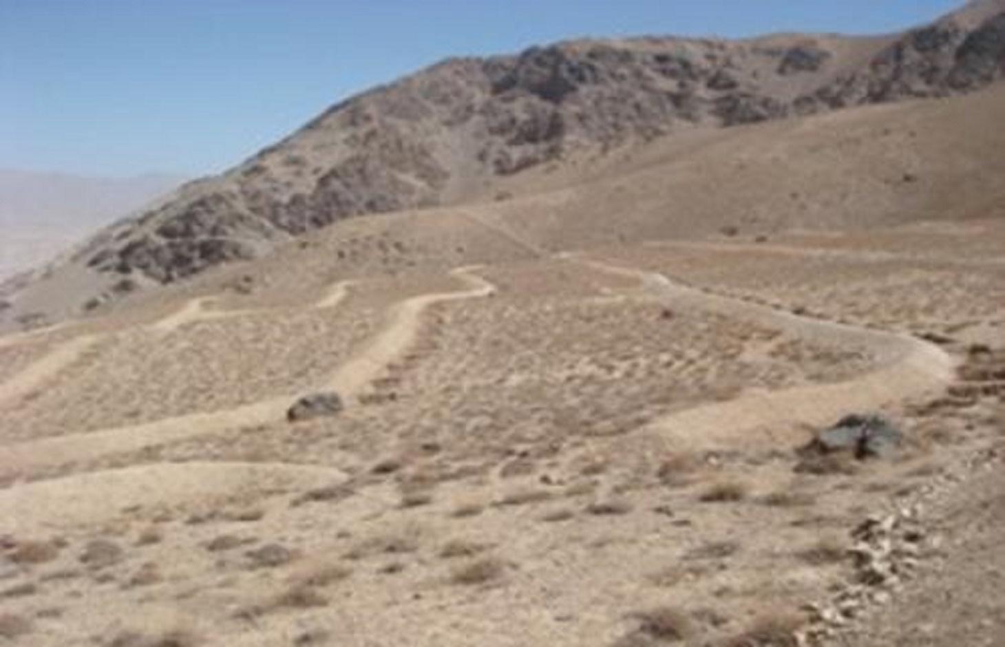
Contour trench bund applied on contour lines of moderate slope to trap run-off to improve infiltration and reduce flash floods.
2.2 ការពណ៌នាលម្អិតពីបច្ចេកទេស
ការពណ៌នា:
The Contour Trench Bund technology is documented by Sustainable Land Management
Project/HELVETAS Swiss Intercooperation with financial support of Swiss Agency for
Development and Cooperation(SDC) and close support and cooperation of the Catholic
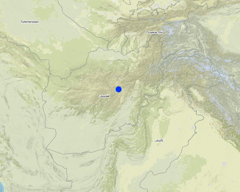
Relief Service (CRS). The technology was applied in Sar-e Ahengaran watershed of Bamyan centre, an area of 0.08 km2 as part of a watershed project by the Catholic Relief Services (CRS). The total watershed area is 67 ha. The project started in October 2009 involving the community with funding support from USAID and CRS. The project came to an end in March 2013.
Purpose of the Technology: The main purpose of the contour trench bund technology is to reduce excessive surface runoff and improve infiltration. It also contributes to increased vegetation cover.
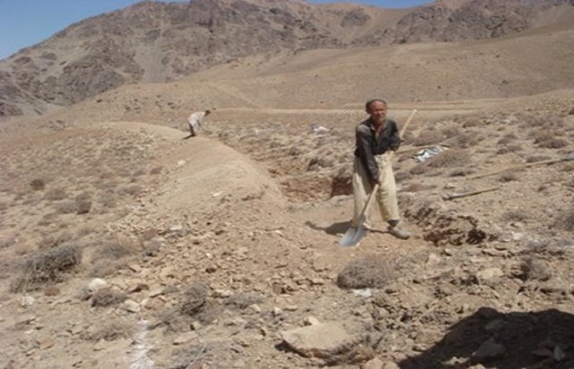
Establishment / maintenance activities and inputs: The main activities for this SLM technology include: site selection and technical planning in October 2009; demarcation of contour lines using A-frame and lime; and digging trenches and construction of soil bunds. The technology was established over 10 months. The project used a “Cash for Work” approach; local people were employed for construction works. Cost-wise, approximately 7,536 USD were spent on this technology (approximately 942 USD/ha) with 90% contribution from the project and 10% from the participating community. There have been no maintenance costs so far for this technology.
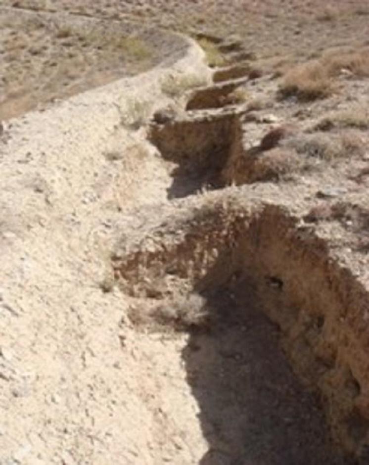
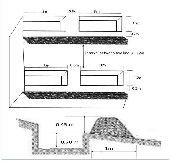
Dimensions of a trenches are: 0.7 m in depth, 1.2 m width, 3 m length and of the bunds: 0.45 m in height, 1.2 m in width, 100 m in length with 12 m spacing and 1.5 m vertical interval between two contour lines. Contour trenches were applied on hilly (16-30%) slopes at an altitude of 2500-3000 m. The technology is tolerant to temperature, seasonal rainfall, storms and droughts and sensitive to heavy rainfall events and floods. The soil in the watershed is sandy to loamy type, and infertile with a depth of 20-50 cm. The infiltration is medium.
The technology is part of the watershed management system. Other measures implemented included stone walls, cultivation of fodder grasses and ban on grazing and shrub cutting at the site. The land ownership (in the watershed) is communal with open access water rights. Medium scale land users, mainly men, applied the technology. Women and school children participated in meetings concerning awareness raising. There is also a watershed and pasture management committee for site management.
Natural / human environment: The annual rainfall in the area is 250-500 mm. The agro-climate is semi-arid and temperate type with the longest growing period of 180 days from April to October. The people in this area are mainly poor. 10-50 % of all income comes from off-farm activities. Access to health, market and financial services is low and education, roads, transport, drinking water and sanitation facilities are moderate. Agriculture is of mixed type, subsistence and commercial based.
2.3 រូបភាពនៃបច្ចេកទេស
វិចិត្រសាលប្រព័ន្ធផ្សព្វផ្សាយ
2.5 ប្រទេស/តំបន់/ទីតាំងកន្លែង ដែលបច្ចេកទេសត្រូវបានអនុវត្ត និងបានគ្រប់ដណ្តប់ដោយការវាយតម្លៃនេះ
ប្រទេស:
ប្រទេសអាហ្វហ្គានិស្ថាន
តំបន់/រដ្ឋ/ខេត្ត:
Sar_e_Ahangaran, Bamyan center
Map
×2.6 កាលបរិច្ឆេទនៃការអនុវត្ត
ប្រសិនបើមិនច្បាស់ឆ្នាំ សូមបញ្ជាក់កាលបរិច្ឆេទដែលប្រហាក់ប្រហែល:
- តិចជាង 10ឆ្នាំមុន (ថ្មី)
2.7 ការណែនាំពីបច្ចេកទេស
សូមបញ្ជាក់តើបច្ចេកទេសត្រូវបានណែនាំឱ្យអនុវត្តដោយរបៀបណា:
- តាមរយៈគម្រោង / អន្តរាគមន៍ពីខាងក្រៅ
3. ចំណាត់ថ្នាក់នៃបច្ចេកទេស SLM
3.1 គោលបំណងចម្បង (១ ឬច្រើន) នៃបច្ចេកទេសនេះ
- ការពារតំបន់ទីជម្រាល/តំបន់ខ្សែទឹកខាងក្រោមបញ្ចូលជាមួយបច្ចេកទេសផ្សេងទៀត
- កាត់បន្ថយហានិភ័យនៃគ្រោះមហន្តរាយ
3.2 ប្រភេទដីប្រើប្រាស់មួយប្រភេទ (ច្រើនប្រភេទ) ដែលបានអនុវត្តបច្ចេកទេស

ដីសម្រាប់ចិញ្ចឹមសត្វ
វាលស្មៅធំៗ:
- ពាក់កណ្តាលពនេចរ
ប្រភេទសត្វ:
- សត្វពាហនៈ - សត្វចិញ្ចឹមយកទឹកដោះ
- សត្វពពែ
- សត្វចៀម
មតិយោបល់:
Major land use problems (compiler’s opinion): Reduction of the vegetation cover causes flash floods and accelerated erosion. The water level goes down and there is no moisture in the soil.
Major land use problems (land users’ perception): Downstream flash flood and shortage of spring water due to overgrazing of the range-land.
Future (final) land use (after implementation of SLM Technology): Grazing land: Gi: Intensive grazing/ fodder production
3.4 ការផ្គត់ផ្គង់ទឹក
ការផ្គត់ផ្គង់ទឹកនៅកន្លែងអនុវត្តបច្ចេកទេស:
- ទឹកភ្លៀង និងប្រព័ន្ធស្រោចស្រព
3.5 ក្រុម SLM ដែលបច្ចេកទេសស្ថិតនៅក្នុង
- ធ្វើឱ្យប្រសើរឡើងគម្របដី/ ដំណាំគម្របដី
- វិធានការអនុវត្តកាត់ទទឹងទីជម្រាល
3.6 វិធានការ SLM ដែលបញ្ចូលនូវបច្ចេកទេស

វិធានការរចនាស័ម្ពន្ធ
- S2: ភ្លឺ ច្រាំង
- S4: កម្រិតភ្លឺ រណ្តៅ
មតិយោបល់:
Main measures: structural measures
3.7 កំណត់ប្រភេទនៃការធ្លាក់ចុះគុណភាពដីសំខាន់ៗដែលបច្ចេកទេសនេះបានដោះស្រាយ

ការហូរច្រោះដីដោយសារទឹក
- Wt: ការបាត់ដីស្រទាប់លើដោយការហូរច្រោះ
មតិយោបល់:
Main causes of degradation: over-exploitation of vegetation for domestic use, overgrazing
3.8 ការពារ កាត់បន្ថយ ឬស្តារឡើងវិញនៃការធ្លាក់ចុះគុណភាពដី
បញ្ជាក់ពីគោលដៅរបស់បច្ចេកទេស ដែលផ្តោតទៅការធ្លាក់ចុះគុណភាពដី:
- ការកាត់បន្ថយការធ្លាក់ចុះគុណភាពដី
4. បច្ចេកទេសជាក់លាក់ សកម្មភាពអនុវត្ត ធាតុចូល និងថ្លៃដើម
4.1 គំនូសបច្ចេកទេសនៃបច្ចេកទេសនេះ
ឈ្មោះអ្នកនិពន្ធ:
Mustafa Ershad
4.2 ព័ត៌មានទូទៅដែលពាក់ព័ន្ធនឹងការគណនាធាតុចូល និងថ្លៃដើម
កំណត់រូបិយប័ណ្ណសម្រាប់ថ្លៃដើម:
- ដុល្លារ
4.3 សកម្មភាពបង្កើត
| សកម្មភាព | រយៈពេល (រដូវកាល) | |
|---|---|---|
| 1. | Demarcation of the contour lines using A frame and Lime | |
| 2. | Excavation of the trenches and construction of the soil bunds |
4.4 ថ្លៃដើម និងធាតុចូលដែលត្រូវការសម្រាប់ការបង្កើតបច្ចេកទេស
| បញ្ជាក់ពីធាតុចូល | ឯកតា | បរិមាណ | ថ្លៃដើមក្នុងមួយឯកតា | ថ្លៃធាតុចូលសរុប | % នៃថ្លៃដើមដែលចំណាយដោយអ្នកប្រើប្រាស់ដី | |
|---|---|---|---|---|---|---|
| កម្លាំងពលកម្ម | Demarcation of the contour lines | ha | 1,0 | 92,0 | 92,0 | |
| កម្លាំងពលកម្ម | Excavation of the trenches and construction of the soil bunds | persons/day/ha | 121,0 | 7,0 | 847,0 | 10,0 |
| ថ្លៃដើមសរុបក្នុងការបង្កើតបច្ចេកទេស | 939,0 | |||||
| ថ្លៃដើមសរុបក្នុងការបង្កើតបច្ចេកទេសគិតជាដុល្លារ | 939,0 | |||||
មតិយោបល់:
Duration of establishment phase: 10 month(s)
4.5 សកម្មភាពថែទាំ
| សកម្មភាព | ពេលវេលា/ ភាពញឹកញាប់ | |
|---|---|---|
| 1. | No maintenance costs so far for CRS. |
4.7 កត្តាសំខាន់បំផុតដែលមានឥទ្ធិពលដល់ការចំណាយ
ពណ៌នាពីកត្តាប៉ះពាល់ចម្បងៗទៅលើថ្លៃដើម:
The establishment duration of the Contour Trench Bund was 10 months.
5. លក្ខណៈបរិស្ថានធម្មជាតិ និងមនុស្ស
5.1 អាកាសធាតុ
បរិមាណទឹកភ្លៀងប្រចាំឆ្នាំ
- < 250 មម
- 251-500 មម
- 501-750 មម
- 751-1,000 មម
- 1,001-1,500 មម
- 1,501-2,000 មម
- 2,001-3,000 មម
- 3,001-4,000 មម
- > 4,000 មម
តំបន់កសិអាកាសធាតុ
- មានភ្លៀងតិចតួច
Thermal climate class: Temperate
5.2 សណ្ឋានដី
ជម្រាលជាមធ្យម:
- រាបស្មើ (0-2%)
- ជម្រាលតិចតួច (3-5%)
- មធ្យម (6-10%)
- ជម្រាលខ្ពស់បន្តិច (11-15%)
- ទីទួល (16-30%)
- ទីទួលចោត (31-60%)
- ទីទួលចោតខ្លាំង (>60%)
ទម្រង់ដី:
- ខ្ពង់រាប
- កំពូលភ្នំ
- ជម្រាលភ្នំ
- ជម្រាលទួល
- ជម្រាលជើងភ្នំ
- បាតជ្រលងភ្នំ
តំបន់តាមរយៈកម្ពស់ :
- 0-100 ម
- 101-500 ម
- 501-1,000 ម
- 1,001-1,500 ម
- 1,501-2,000 ម
- 2,001-2,500 ម
- 2,501-3,000 ម
- 3,001-4,000 ម
- > 4,000 ម
5.3 ដី
ជម្រៅដីជាមធ្យម:
- រាក់ខ្លាំង (0-20 សម)
- រាក់ (21-50 សម)
- មធ្យម (51-80 សម)
- ជ្រៅ (81-120 សម)
- ជ្រៅខ្លាំង (> 120 សម)
វាយនភាពដី (ស្រទាប់លើ):
- គ្រើម/ មានពន្លឺ (ខ្សាច់)
- មធ្យម (ល្បាយ, ល្បាប់)
សារធាតុសរីរាង្គនៅស្រទាប់ដីខាងលើ:
- ទាប (<1%)
បើអាចសូមភ្ជាប់ការពណ៌នាពីដីឱ្យបានច្បាស់ ឬព័ត៌មានដែលអាចទទួលបាន ឧ. ប្រភេទដី, pH ដី/ ជាតិអាស៊ីត, សមត្ថភាពផ្លាស់ប្តូរកាចុង, វត្តមាននីត្រូសែន, ភាពប្រៃ ។ល។:
Soil fertility is low - medium
Soil drainage / infiltration is medium
Soil water storage capacity is medium
5.4 ទឹកដែលអាចទាញមកប្រើប្រាស់បាន និងគុណភាពទឹក
នីវ៉ូទឹកក្រោមដី:
5-50 ម
ទឹកលើដីដែលអាចទាញយកប្រើប្រាស់បាន:
មិនមាន/ គ្មាន
គុណភាពទឹក (មិនបានធ្វើប្រត្តិកម្ម):
ទឹកពិសារដែលមានគុណភាពល្អ
5.5 ជីវៈចម្រុះ
ភាពសម្បូរបែបនៃប្រភេទ:
- កម្រិតមធ្យម
5.6 លក្ខណៈនៃអ្នកប្រើប្រាស់ដីដែលអនុវត្តបច្ចេកទេស
ទីផ្សារនៃប្រព័ន្ធផលិតកម្ម:
- ពាក់កណ្តាលពាណិជ្ជកម្ម (ផ្គត់ផ្គង់ខ្លួនឯង/ ពាណិជ្ជកម្ម)
ចំណូលក្រៅកសិកម្ម:
- 10-50% នៃចំណូល
កម្រិតជីវភាព:
- មិនល្អ
ឯកជន ឬក្រុម:
- ជាក្រុម/ សហគមន៍
យេនឌ័រ:
- បុរស
សូមបញ្ជាក់ពីលក្ខណៈពាក់ព័ន្ធផ្សេងទៀតអំពីអ្នកប្រើប្រាស់ដី:
Difference in the involvement of women and men: Workload does not give chance to women to work on the mountains.
Population density: < 10 persons/km2
Annual population growth: 2% - 3%
50% of the land users are poor.
Off-farm income specification: Busy with carpentry and migrate for work.
5.7 ទំហំផ្ទៃដីជាមធ្យមនៃដីប្រើប្រាស់ដោយអ្នកប្រើប្រាស់ដី ក្នុងការអនុវត្តបច្ចេកទេស
- < 0.5 ហិកតា
- 0.5-1 ហិកតា
- 1-2 ហិកតា
- 2-5 ហិកតា
- 5-15 ហិកតា
- 15-50 ហិកតា
- 50-100 ហិកតា
- 100-500 ហិកតា
- 500-1,000 ហិកតា
- 1,000-10,000 ហិកតា
- > 10,000 ហិកតា
តើផ្ទៃដីនេះចាត់ទុកជាទំហំកម្រិតណាដែរ ខ្នាតតូច មធ្យម ឬខ្នាតធំ (ធៀបនឹងបរិបទតំបន់)?
- ខ្នាតមធ្យម
5.8 ភាពជាម្ចាស់ដី កម្មសិទ្ធប្រើប្រាស់ដី និងកម្មសិទ្ធប្រើប្រាស់ទឹក
ភាពជាម្ចាស់ដី:
- ភូមិ
កម្មសិទ្ធិប្រើប្រាស់ដី:
- ជាក្រុម (មានដែនកំណត់)
កម្មសិទ្ធប្រើប្រាស់ទឹក:
- អាស្រ័យផលសេរី (មិនមានការកំណត់)
5.9 ការប្រើប្រាស់សេវាកម្ម និងហេដ្ឋារចនាសម្ព័ន្ធ
សុខភាព:
- មិនល្អ
- មធ្យម
- ល្អ
ការអប់រំ:
- មិនល្អ
- មធ្យម
- ល្អ
ជំនួយបច្ចេកទេស:
- មិនល្អ
- មធ្យម
- ល្អ
ការងារ (ឧ. ការងារក្រៅកសិដ្ឋាន):
- មិនល្អ
- មធ្យម
- ល្អ
ទីផ្សារ:
- មិនល្អ
- មធ្យម
- ល្អ
ថាមពល:
- មិនល្អ
- មធ្យម
- ល្អ
ផ្លូវ និងការដឹកជញ្ជូន:
- មិនល្អ
- មធ្យម
- ល្អ
ទឹកផឹក និងអនាម័យ:
- មិនល្អ
- មធ្យម
- ល្អ
សេវាកម្មហិរញ្ញវត្ថុ:
- មិនល្អ
- មធ្យម
- ល្អ
6. ផលប៉ះពាល់ និងការសន្និដ្ឋាន
6.1 ផលប៉ះពាល់ក្នុងបរិវេណអនុវត្តបច្ចេកទេសដែលកើតមាន
ផលប៉ះពាល់លើសេដ្ឋកិច្ចសង្គម
ផលិតផល
ផលិតកម្មចំណីសត្វ
មតិយោបល់/ ការបញ្ជាក់:
Due to better soil moisture
ចំណូល និងថ្លៃដើម
ភាពសម្បូរបែបប្រភពប្រាក់ចំណូល
ផលប៉ះពាល់ទៅលើវប្បធម៌សង្គម
ចំណេះដឹង SLM / ការធ្លាក់ចុះគុណភាពដី
ស្ថានភាពក្រុមដែលមានបញ្ហាក្នុងសង្គម និងសេដ្ឋកិច្ច
livelihood and human well-being
មតិយោបល់/ ការបញ្ជាក់:
Due to reduction in flash floods problem and increased access to drinking water, Seasonal job opportunities created through cash for work
ផលប៉ះពាល់ទៅលើអេកូឡូស៊ី
វដ្តទឹក/លំហូរ
ការប្រមូលស្តុកទុកទឹក
មតិយោបល់/ ការបញ្ជាក់:
of surface run off
នីវ៉ូទឹកក្រោមដី/ ដង្ហើមទឹក
ដី
សំណើមដី
ការបាត់បង់ដី
ជីវចម្រុះ៖ ដំណាំ, សត្វ
ជីវម៉ាស/ កាបូនលើដី
មតិយោបល់/ ការបញ្ជាក់:
Due to more moisture
ការកាត់បន្ថយហានិភ័យនៃគ្រោះមហន្តរាយ និងគ្រោះអាកាសធាតុ
ផលប៉ះពាល់នៃទឹកជំនន់
ផលប៉ះពាល់ទៅលើអេកូឡូស៊ីផ្សេងៗ
disturbance of soil and vegetation during excavation works
6.2 ផលប៉ះពាល់ក្រៅបរិវេណអនុវត្តបច្ចេកទេសដែលកើតមាន
ទឹកដែលអាចទាញមកប្រើប្រាស់បាន
ទឹកជំនន់ខ្សែទឹកខាងក្រោម
កំណកល្បាប់ខ្សែទឹកខាងក្រោម
មតិយោបល់/ ការបញ្ជាក់:
And sedimentation
damage on agriculture fields
As the site is closed, grazing pressure shifts elsewhere
6.3 ភាពប្រឈម និងភាពរួសនៃបច្ចេកទេសទៅនឹងការប្រែប្រួលអាកាសធាតុ និងគ្រោះអាកាសធាតុ/ គ្រោះមហន្តរាយ (ដែលដឹងដោយអ្នកប្រើប្រាស់ដី)
ការប្រែប្រួលអាកាសធាតុ
ការប្រែប្រួលអាកាសធាតុ
| រដូវកាល | កើនឡើង ឬថយចុះ | លក្ខណៈឆ្លើយតបនៃបច្ចេកទេសទៅនឹងការប្រែប្រួលអាកាសធាតុ | |
|---|---|---|---|
| សីតុណ្ហភាពប្រចាំឆ្នាំ | កើនឡើង | ល្អ |
គ្រោះអាកាសធាតុ (មហន្តរាយ)
គ្រោះមហន្តរាយធម្មជាតិ
| លក្ខណៈឆ្លើយតបនៃបច្ចេកទេសទៅនឹងការប្រែប្រួលអាកាសធាតុ | |
|---|---|
| ព្យុះកំបុតត្បូងតាមតំបន់ | ល្អ |
គ្រោះមហន្តរាយអាកាសធាតុ
| លក្ខណៈឆ្លើយតបនៃបច្ចេកទេសទៅនឹងការប្រែប្រួលអាកាសធាតុ | |
|---|---|
| រាំងស្ងួត | ល្អ |
ផលវិបាកដែលទាក់ទងនឹងបរិយាកាសផ្សេងៗទៀត
ផលវិបាកដែលទាក់ទងនឹងបរិយាកាសផ្សេងៗទៀត
| លក្ខណៈឆ្លើយតបនៃបច្ចេកទេសទៅនឹងការប្រែប្រួលអាកាសធាតុ | |
|---|---|
| Extreme precipitation events especially if the technology is applied on steep slopes. | មិនល្អ |
មតិយោបល់:
Increase size, stable bunds stabilized with vegetation
6.4 ការវិភាគថ្លៃដើម និងអត្ថប្រយោជន៍
តើផលចំណេញ និងថ្លៃដើមត្រូវបានប្រៀបធៀបគ្នាយ៉ាងដូចម្តេច (ទស្សនៈរបស់អ្នកប្រើប្រាស់ដី)?
រយៈពេលខ្លី:
អវិជ្ជមានតិចតួច
រយៈពេលវែង:
វិជ្ជមាន
តើផលចំណេញ និងការថែទាំ/ ជួសជុលត្រូវបានប្រៀបធៀបគ្នាយ៉ាងដូចម្តេច (ទស្សនៈរបស់អ្នកប្រើប្រាស់ដី)?
រយៈពេលខ្លី:
ប៉ះពាល់តិចតួចបំផុត
រយៈពេលវែង:
វិជ្ជមានខ្លាំង
មតិយោបល់:
The benefits will be more in the long term when trees, shrubs and fodder grasses are ready to harvest.
6.5 ការទទួលយកបច្ចេកទេស
មតិយោបល់:
Comments on acceptance with external material support: Appropriate information is not available.
Comments on spontaneous adoption: Only soil bunds have been applied by a few farmers on their private lands.
6.7 ភាពខ្លាំង/ គុណសម្បត្តិ/ ឱកាសនៃបច្ចេកទេស
| ភាពខ្លាំង/ គុណសម្បត្តិ/ ឱកាសនៅកន្លែងរបស់អ្នកប្រើប្រាស់ដី |
|---|
|
The technology helps to create SLM based job opportunities for many people. How can they be sustained / enhanced? Needs external support/projects. |
| ភាពខ្លាំង/ គុណសម្បត្តិ/ ឱកាស ទស្សនៈរបស់បុគ្គលសំខាន់ៗ |
|---|
|
Demonstration of link between SLM measures and water source. How can they be sustained / enhanced? Conducting training and showing drawing. |
|
Technical knowledge of community enhanced. How can they be sustained / enhanced? Share more aspects of the technology, where to apply and how. |
|
Flood reduction, greening of the area, increase the spring water. How can they be sustained / enhanced? Cultivate native plants, share experiences with more communities and SLM specialists. |
|
Good for land rehabilitation (extremely degraded lands). How can they be sustained / enhanced? Always combine with vegetative and management measures. |
6.8 ភាពខ្សោយ/ គុណវិបត្តិ/ ហានិភ័យនៃបច្ចេកទេស និងវិធីសាស្ត្រដោះស្រាយ
| ភាពខ្សោយ/ គុណវិបត្តិ/ ហានិភ័យ ទស្សនៈរបស់អ្នកប្រើប្រាស់ដី | តើបច្ចេកទេសទាំងនោះបានដោះស្រាយបញ្ហាដូចម្តេច? |
|---|---|
| Farmers do not prefer to construct this technology because it requires soil excavation/disturbance. | One needs to show how such measures have been applied in other parts of the world for multiple benefits through action research. |
| ភាពខ្សោយ/ គុណវិបត្តិ/ ហានិភ័យ ទស្សនៈរបស់អ្នកចងក្រងឬបុគ្គលសំខាន់ៗ | តើបច្ចេកទេសទាំងនោះបានដោះស្រាយបញ្ហាដូចម្តេច? |
|---|---|
| Site selection | Apply technology at suitable site that has proper slope and is really degraded. Avoid places where there is already good vegetation cover. |
| Higher cost of establishment of the technology. | Encourage the community for more contribution or apply where absolutely necessary. |
| Technical design | The designer should research more about the site and discuss with the skilled people of the community before designing. |
| Few vegetative measures | plant fodder grasses and adapted trees between trenches. |
7. ឯកសារយោង និងវេបសាយ
7.1 វិធីសាស្ត្រ/ ប្រភពនៃព័ត៌មាន
ការតភ្ជាប់ និងម៉ូឌុល
ពង្រីកមើលទាំងអស់ បង្រួមទាំងអស់ការតភ្ជាប់
Community-Based Watershed Management [ប្រទេសអាហ្វហ្គានិស្ថាន]
Sustainable implementation of watershed management through appropriate SLM technologies, formation of organizational structures and capacity building of stakeholders
- អ្នកចងក្រង៖ Aqila Haidery
ម៉ូឌុល
គ្មានម៉ូឌុល