Mangroves as Buffer against Natural Hazards [ប្រទេសហ្វីលីពីន]
- ការបង្កើត៖
- បច្ចុប្បន្នភាព
- អ្នកចងក្រង៖ Philippine Overview of Conservation Approaches and Technologies
- អ្នកកែសម្រួល៖ –
- អ្នកត្រួតពិនិត្យច្រើនទៀត៖ Ursula Gaemperli, Alexandra Gavilano
"Bakauan"
technologies_578 - ប្រទេសហ្វីលីពីន
ពិនិត្យមើលគ្រប់ផ្នែក
ពង្រីកមើលទាំងអស់ បង្រួមទាំងអស់1. ព័ត៌មានទូទៅ
1.2 ព័ត៌មានលម្អិតពីបុគ្គលសំខាន់ៗ និងស្ថាប័នដែលចូលរួមក្នុងការវាយតម្លៃ និងចងក្រងឯកសារនៃបច្ចេកទេស
បុគ្គលសំខាន់ម្នាក់ (ច្រើននាក់)
អ្នកជំនាញឯកទេស SLM:
Dinamling Djolly Ma.
Bureau of Soils and Water Management
ប្រទេសហ្វីលីពីន
អ្នកជំនាញឯកទេស SLM:
Gultiano Wilfredo
Bureau of Soils and Water Management
ប្រទេសហ្វីលីពីន
អ្នកជំនាញឯកទេស SLM:
Abarro II Ace Wilfred
Bureau of Soils and Water Management
អ្នកជំនាញឯកទេស SLM:
Lofranco Rufino
DENR-Community Environment and Natural Resources Talibon
ឈ្មោះគម្រោងដែលបានចងក្រងឯកសារ/ វាយតម្លៃលើបច្ចេកទេស (បើទាក់ទង)
Decision Support for Mainstreaming and Scaling out Sustainable Land Management (GEF-FAO / DS-SLM)1.3 លក្ខខណ្ឌទាក់ទងទៅនឹងការប្រើប្រាស់ទិន្នន័យដែលបានចងក្រងតាមរយៈ វ៉ូខេត
អ្នកចងក្រង និង(បុគ្គលសំខាន់ៗ)យល់ព្រមទទួលយកនូវលក្ខខណ្ឌនានាទាក់ទងទៅនឹងការប្រើប្រាស់ទិន្នន័យដែលបានចងក្រងតាមរយៈវ៉ូខេត:
បាទ/ចា៎
1.4 សេចក្តីប្រកាសស្តីពីចីរភាពនៃការពណ៌នាពីបច្ចេកទេស
តើបច្ចេកទេសដែលបានពណ៌នានេះមានបញ្ហាដែលផ្តោតលើការធ្លាក់ចុះគុណភាពដី, បើដូច្នេះវាមិនអាចត្រូវបានប្រកាសថាជាបច្ចេកទេសនៃការគ្រប់គ្រងប្រកបដោយចីរភាពទេ?
ទេ
2. ការពណ៌នាពីបច្ចេកទេស SLM
2.1 ការពណ៌នាដោយសង្ខេបពីបច្ចេកទេស
និយមន័យបច្ចេកទេស:
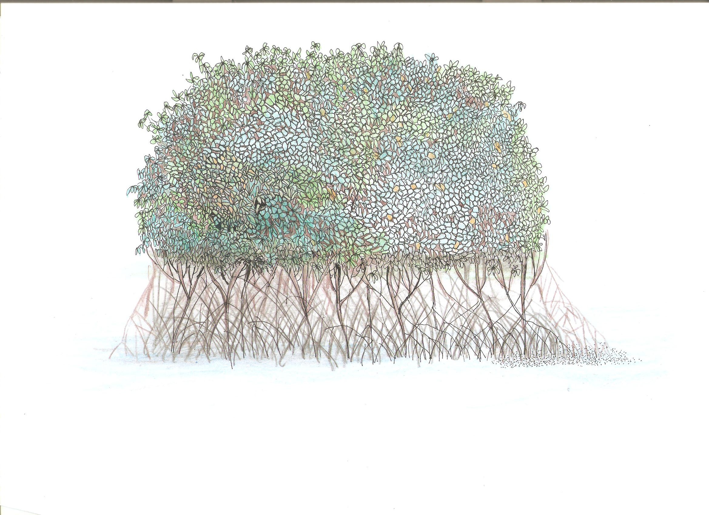
Mangroves "bakauan" are planted in the island coast to form barriers and as first line of defense during storm surges.
2.2 ការពណ៌នាលម្អិតពីបច្ចេកទេស
ការពណ៌នា:
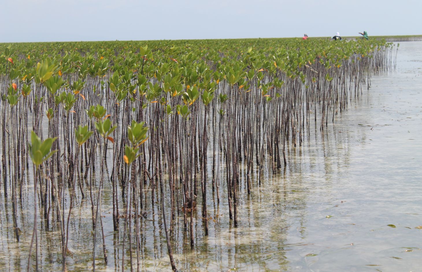
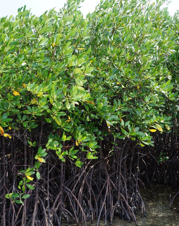
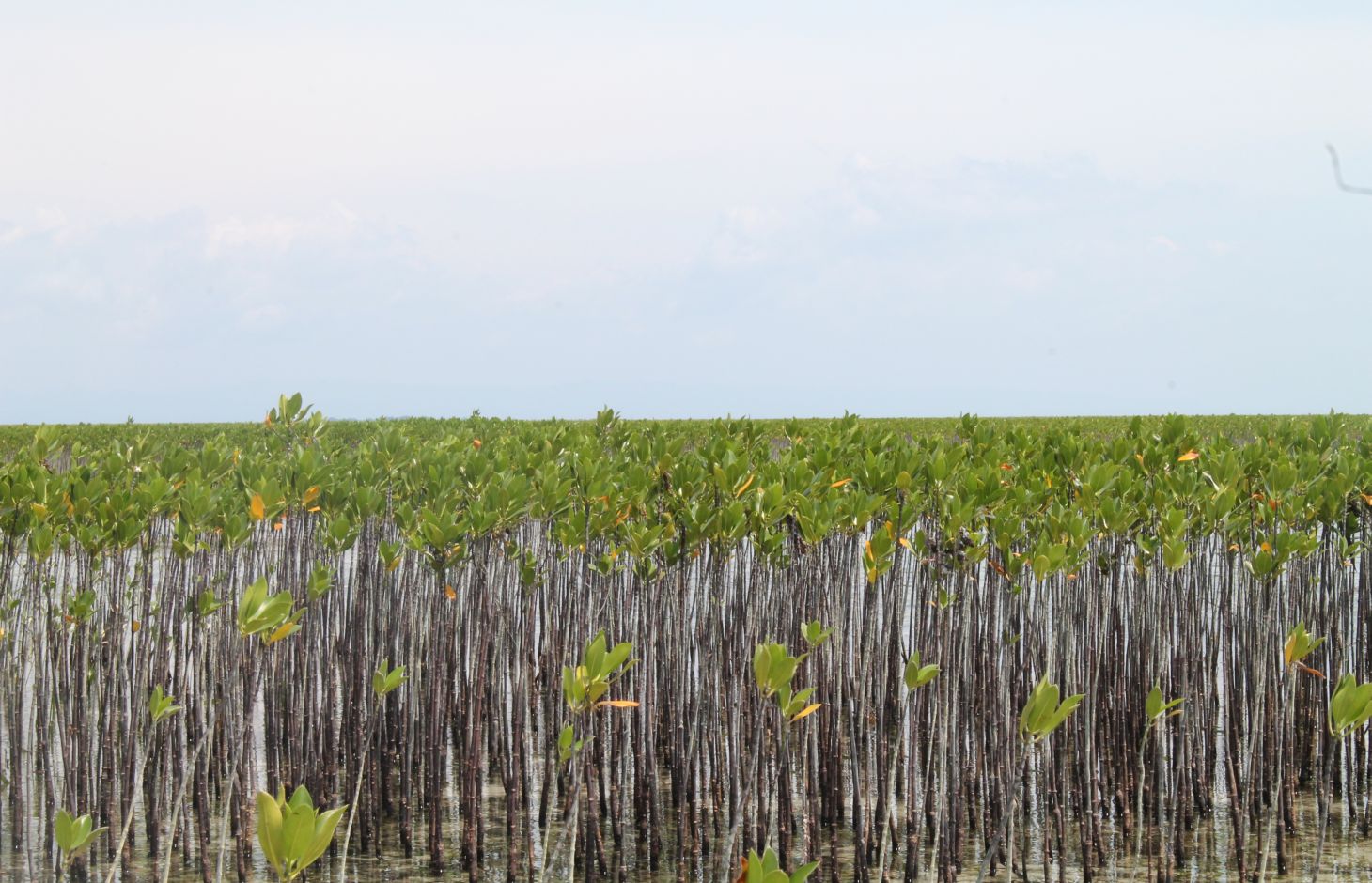
Mangrove plantation in the island of Banacon which is 10.91 kilometers away from the municipality of Getafe, Bohol in Central Visayas started in 1957.The most common specie grown is the “Bakauan” under the Rhizophoracea family.
Mangroves contribute in protecting the coast against natural hazards such as storms, tsunamis and coastal erosion. It weakens the impact of typhoons that bring strong winds, continuous high waves and storm surges. A dense cluster of bakauans obstruct the entry of winds and waves when passing through the mangroves minimizes the force of wind sand waves. According to the residents of the island, they were spared from total destruction of properties during onset of typhoons because of the presence of the bakauans. Mangroves were utilized also by the Banacon residents as source of poles for houses, fishpens and charcoals for cooking. The dense roots of the trees bind the soils thus preventing erosion. The tree roots serve as spawning ground for fishes and other variety of sea species that lead to an increase in harvest of sea foods in the area. The mangrove plantation was also developed into ecotourism site.
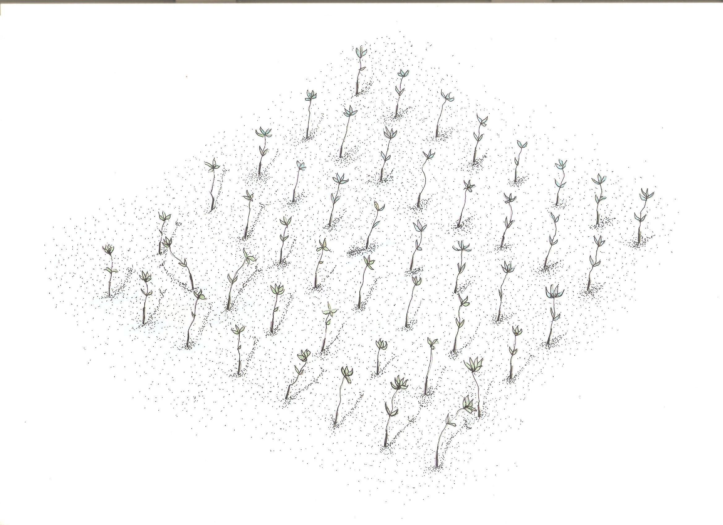
Site evaluation is the pre-requisite in the establishment of mangrove area. An ideal area is with sand dune during low tide. It is followed by site lay out using the planting design that is adopted, and direct planting of propagules in the soil. Planting materials used are the cigar-shaped mature propagules harvested from the Bacauan- Lalake specie of mangroves. The direct seeding planting is the ideal method of planting in establishing a mangroves plantation. Mangrove propagules must be planted after collection. It should not be exposed to direct sunlight to prevent moisture loss.
There are (3) planting designs used in the establishment of the mangroves. First, the high density planting of propagules with no lay out to be followed. This planting design can accommodate 30,000 pcs of propagules per hectare. Second, design has a spacing of 1 meter by 1 meter planted in rows and can hold 10,000 pieces of propagules per hectare. Third is the block/cluster design in which each cluster was planted with 750 pieces of propagules with a distance of 30 centimeters apart per propagules. The spacing between the blocks or cluster is 10 meters and can contain 5,000 pieces of propagules per hectare. Maintenance includes monitoring of the crop status, replanting of missing hills and weeding by removing sea weeds, barnacles and sea debris.
2.3 រូបភាពនៃបច្ចេកទេស
វិចិត្រសាលប្រព័ន្ធផ្សព្វផ្សាយ
2.5 ប្រទេស/តំបន់/ទីតាំងកន្លែង ដែលបច្ចេកទេសត្រូវបានអនុវត្ត និងបានគ្រប់ដណ្តប់ដោយការវាយតម្លៃនេះ
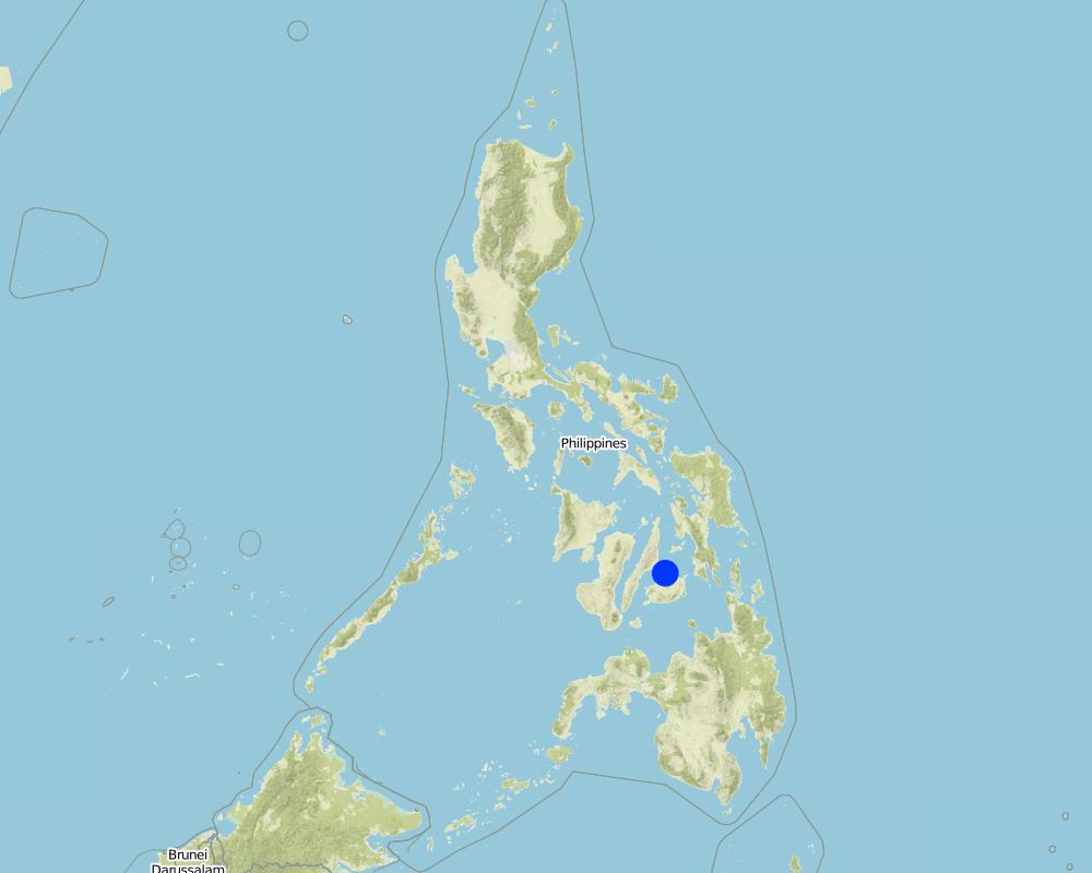
ប្រទេស:
ប្រទេសហ្វីលីពីន
តំបន់/រដ្ឋ/ខេត្ត:
Bohol
បញ្ជាក់បន្ថែមពីលក្ខណៈនៃទីតាំង:
Banacon Island, Getafe
បញ្ជាក់ពីការសាយភាយនៃបច្ចេកទេស:
- ត្រូវបានផ្សព្វផ្សាយត្រឹមតំបន់មួយ
ប្រសិនបើមិនច្បាស់ពីទំហំផ្ទៃដី សូមធ្វើការប៉ាន់ប្រម៉ាណ:
- 1-10 គម2
Map
×2.6 កាលបរិច្ឆេទនៃការអនុវត្ត
ប្រសិនបើមិនច្បាស់ឆ្នាំ សូមបញ្ជាក់កាលបរិច្ឆេទដែលប្រហាក់ប្រហែល:
- ច្រើនជាង 50 ឆ្នាំមុន (ប្រពៃណី)
2.7 ការណែនាំពីបច្ចេកទេស
សូមបញ្ជាក់តើបច្ចេកទេសត្រូវបានណែនាំឱ្យអនុវត្តដោយរបៀបណា:
- ជាផ្នែកនៃប្រព័ន្ធប្រពៃណី (> 50 ឆ្នាំ)
- តាមរយៈគម្រោង / អន្តរាគមន៍ពីខាងក្រៅ
មតិយោបល់ (ប្រភេទនៃគម្រោង ។ល។):
This was started in the 1950's by Ernesto Pandi and supported by the DENR through programs such as National Greening Program, Community Based Forest Management
3. ចំណាត់ថ្នាក់នៃបច្ចេកទេស SLM
3.1 គោលបំណងចម្បង (១ ឬច្រើន) នៃបច្ចេកទេសនេះ
- អភិរក្សប្រព័ន្ធអេកូឡូស៊ី
- អភិរក្ស/ធ្វើឱ្យប្រសើរឡើងជីវចម្រុះ
- កាត់បន្ថយហានិភ័យនៃគ្រោះមហន្តរាយ
- បន្ស៊ាំទៅនឹងការប្រែប្រួលអាកាសធាតុ/គ្រោះមហន្តរាយ និងផលប៉ះពាល់របស់វា
- កាត់បន្ថយការប្រែប្រួលអាកាសធាតុ និងផលប៉ះពាល់របស់វា
- បង្កើតផលប្រយោជន៍សេដ្ឋកិច្ច
- បង្កើតផលប្រយោជន៍សង្គម
3.2 ប្រភេទដីប្រើប្រាស់មួយប្រភេទ (ច្រើនប្រភេទ) ដែលបានអនុវត្តបច្ចេកទេស

ដីព្រៃ/ដីដាំដើមឈើ
- Crustaceans breeding ground
ផលិតផល និងសេវាកម្ម:
- ការអភិរក្ស/ការការពារធម្មជាតិ
- ការកំសាន្ត/ទេសចរណ៍
- ការពារពីគ្រោះធម្មជាតិ
មតិយោបល់:
Perennial trees
3.4 ការផ្គត់ផ្គង់ទឹក
ការផ្គត់ផ្គង់ទឹកនៅកន្លែងអនុវត្តបច្ចេកទេស:
- ទឹកភ្លៀង
3.5 ក្រុម SLM ដែលបច្ចេកទេសស្ថិតនៅក្នុង
- គ្រប់គ្រងការដាំព្រៃឈើ
- កាត់បន្ថយហានិភ័យនៃបញ្ហាលើប្រព័ន្ធអេកូឡូស៊ី
3.6 វិធានការ SLM ដែលបញ្ចូលនូវបច្ចេកទេស

វិធានការរុក្ខជាតិ
- V1: ឈើធំៗ និងដើមឈើតូចៗ
3.7 កំណត់ប្រភេទនៃការធ្លាក់ចុះគុណភាពដីសំខាន់ៗដែលបច្ចេកទេសនេះបានដោះស្រាយ

ការធ្លាក់ចុះជីវសាស្ត្រនៃដី
- Bc: ការថយចុះនូវគម្របរុក្ខជាតិ
- Bh: ការបាត់បង់ទីជំរក
3.8 ការពារ កាត់បន្ថយ ឬស្តារឡើងវិញនៃការធ្លាក់ចុះគុណភាពដី
បញ្ជាក់ពីគោលដៅរបស់បច្ចេកទេស ដែលផ្តោតទៅការធ្លាក់ចុះគុណភាពដី:
- ការការពារការធ្លាក់ចុះគុណភាពដី
4. បច្ចេកទេសជាក់លាក់ សកម្មភាពអនុវត្ត ធាតុចូល និងថ្លៃដើម
4.1 គំនូសបច្ចេកទេសនៃបច្ចេកទេសនេះ
លក្ខណៈពិសេសនៃបច្ចេកទេស (ទាក់ទងនឺងគំនូរបច្ចេកទេស):
There are (3) planting designs used in the establishment of the mangroves. First, the high density planting of propagules with no lay out to be followed. This planting design can accommodate 30,000 pcs of propagules per hectare. Second, design has a spacing of 1 meter by 1 meter planted in rows and can hold 10,000 pieces of propagules per hectare. Third is the block/cluster design in which each cluster was planted with 750 pieces of propagules with a distance of 30 centimeters apart per propagules. The spacing between the blocks or cluster is 10 meters and can contain 5,000 pieces of propagules per hectare. Maintenance includes monitoring of the crop status, replanting of missing hills and weeding by removing sea weeds, barnacles and sea debris.
ឈ្មោះអ្នកនិពន្ធ:
Patricio A. Yambot
កាលបរិច្ឆេទ:
10/07/2016
ឈ្មោះអ្នកនិពន្ធ:
Patricio A. Yambot
កាលបរិច្ឆេទ:
10/07/2017
4.2 ព័ត៌មានទូទៅដែលពាក់ព័ន្ធនឹងការគណនាធាតុចូល និងថ្លៃដើម
កំណត់របៀបនៃការគណនាថ្លៃដើម និងធាតុចូល:
- ក្នុងតំបន់អនុវត្តបច្ចេកទេស
កំណត់ទំហំ និងឯកត្តាផ្ទៃដី:
1 hectare
ផ្សេងៗ/ រូបិយប័ណ្ណជាតិ (បញ្ជាក់):
Philippine peso
បើពាក់ព័ន្ធសូមកំណត់អត្រាប្តូរប្រាក់ពីដុល្លាទៅរូបិយប័ណ្ណតំបន់ (ឧ. 1 ដុល្លារ = 79.9 រៀលនៃរូបិយប័ណ្ណប្រេស៊ីល) ៖ 1 ដុល្លារ =:
50,0
កំណត់ថ្លៃឈ្នួលជាមធ្យមនៃការជួលកម្លាំងពលកម្មក្នុងមួយថ្ងៃ:
250
4.3 សកម្មភាពបង្កើត
| សកម្មភាព | រយៈពេល (រដូវកាល) | |
|---|---|---|
| 1. | Harvesting of matured propagules | During the month of June |
| 2. | Direct seeding of propagules | During low tide |
4.4 ថ្លៃដើម និងធាតុចូលដែលត្រូវការសម្រាប់ការបង្កើតបច្ចេកទេស
| បញ្ជាក់ពីធាតុចូល | ឯកតា | បរិមាណ | ថ្លៃដើមក្នុងមួយឯកតា | ថ្លៃធាតុចូលសរុប | % នៃថ្លៃដើមដែលចំណាយដោយអ្នកប្រើប្រាស់ដី | |
|---|---|---|---|---|---|---|
| កម្លាំងពលកម្ម | Person day/ hectare | 10,0 | 250,0 | 2500,0 | ||
| សម្ភារៈដាំដុះ | mangrove propagules | pieces | 5000,0 | 1,0 | 5000,0 | |
| ថ្លៃដើមសរុបក្នុងការបង្កើតបច្ចេកទេស | 7500,0 | |||||
| ថ្លៃដើមសរុបក្នុងការបង្កើតបច្ចេកទេសគិតជាដុល្លារ | 150,0 | |||||
ប្រសិនបើអ្នកប្រើប្រាស់ដីមិនមានថ្លៃដើម 100% សូមបញ្ជាក់ថានរណាដែលចំណាយថ្លៃដើមដែលនៅសល់:
The cost was funded by the government through the Department of Environment and Natural Resources (DENR)
4.5 សកម្មភាពថែទាំ
| សកម្មភាព | ពេលវេលា/ ភាពញឹកញាប់ | |
|---|---|---|
| 1. | Replanting of propagules | monthly |
| 2. | Weeding and cleaning of site | monthly |
4.6 កំណត់ថ្លៃដើមសម្រាប់ការថែទាំ/ សកម្មភាពរបស់បច្ចេកទេស (ក្នុងរយៈពេលមួយឆ្នាំ)
| បញ្ជាក់ពីធាតុចូល | ឯកតា | បរិមាណ | ថ្លៃដើមក្នុងមួយឯកតា | ថ្លៃធាតុចូលសរុប | % នៃថ្លៃដើមដែលចំណាយដោយអ្នកប្រើប្រាស់ដី | |
|---|---|---|---|---|---|---|
| កម្លាំងពលកម្ម | labour | person day | 3,0 | 250,0 | 750,0 | |
| សម្ភារៈដាំដុះ | propragules | pieces | 250,0 | 1,0 | 250,0 | |
| ថ្លៃដើមសរុបសម្រាប់ការថែទាំដំណាំតាមបច្ចេកទេស | 1000,0 | |||||
| ថ្លៃដើមសរុបសម្រាប់ការថែទាំដំណាំតាមបច្ចេកទេសគិតជាដុល្លារ | 20,0 | |||||
ប្រសិនបើអ្នកប្រើប្រាស់ដីមិនមានថ្លៃដើម 100% សូមបញ្ជាក់ថានរណាដែលចំណាយថ្លៃដើមដែលនៅសល់:
The cost was funded by the government through the Department of Environment and Natural Resources (DENR)
5. លក្ខណៈបរិស្ថានធម្មជាតិ និងមនុស្ស
5.1 អាកាសធាតុ
បរិមាណទឹកភ្លៀងប្រចាំឆ្នាំ
- < 250 មម
- 251-500 មម
- 501-750 មម
- 751-1,000 មម
- 1,001-1,500 មម
- 1,501-2,000 មម
- 2,001-3,000 មម
- 3,001-4,000 មម
- > 4,000 មម
តំបន់កសិអាកាសធាតុ
- សើម
5.2 សណ្ឋានដី
ជម្រាលជាមធ្យម:
- រាបស្មើ (0-2%)
- ជម្រាលតិចតួច (3-5%)
- មធ្យម (6-10%)
- ជម្រាលខ្ពស់បន្តិច (11-15%)
- ទីទួល (16-30%)
- ទីទួលចោត (31-60%)
- ទីទួលចោតខ្លាំង (>60%)
ទម្រង់ដី:
- ខ្ពង់រាប
- កំពូលភ្នំ
- ជម្រាលភ្នំ
- ជម្រាលទួល
- ជម្រាលជើងភ្នំ
- បាតជ្រលងភ្នំ
តំបន់តាមរយៈកម្ពស់ :
- 0-100 ម
- 101-500 ម
- 501-1,000 ម
- 1,001-1,500 ម
- 1,501-2,000 ម
- 2,001-2,500 ម
- 2,501-3,000 ម
- 3,001-4,000 ម
- > 4,000 ម
បញ្ជាក់ថាតើបច្ចេកទេសនេះត្រូវបានអនុវត្តន៍នៅក្នុង:
- មិនពាក់ព័ន្ធទាំងអស់
5.3 ដី
ជម្រៅដីជាមធ្យម:
- រាក់ខ្លាំង (0-20 សម)
- រាក់ (21-50 សម)
- មធ្យម (51-80 សម)
- ជ្រៅ (81-120 សម)
- ជ្រៅខ្លាំង (> 120 សម)
វាយនភាពដី (ស្រទាប់លើ):
- គ្រើម/ មានពន្លឺ (ខ្សាច់)
វាយនភាពដី (> 20 សម ស្រទាប់ក្នុង):
- គ្រើម/ មានពន្លឺ (ខ្សាច់)
សារធាតុសរីរាង្គនៅស្រទាប់ដីខាងលើ:
- ទាប (<1%)
5.4 ទឹកដែលអាចទាញមកប្រើប្រាស់បាន និងគុណភាពទឹក
គុណភាពទឹក (មិនបានធ្វើប្រត្តិកម្ម):
ទឹកមិនអាចប្រើប្រាស់បាន
តើទឹកជំនន់កំពុងកើតមាននៅតំបន់នេះដែររឺទេ?
បាទ/ចា៎
ភាពទៀងទាត់:
ញឹកញាប់
មតិយោបល់ និងលក្ខណៈពិសេសផ្សេងៗទៀតលើគុណភាព និងបរិមាណទឹក :
Frequent flooding as mangrove forests are a part of the coastal marine ecosystem region
5.5 ជីវៈចម្រុះ
ភាពសម្បូរបែបនៃប្រភេទ:
- ខ្ពស់
ភាពសម្បូរបែបនៃទីជម្រក:
- ខ្ពស់
5.6 លក្ខណៈនៃអ្នកប្រើប្រាស់ដីដែលអនុវត្តបច្ចេកទេស
នៅមួយកន្លែង ឬពនេចរ :
- នៅមួយកន្លែង
ចំណូលក្រៅកសិកម្ម:
- ច្រើនជាង 50% នៃចំណូល
កម្រិតជីវភាព:
- មធ្យម
ឯកជន ឬក្រុម:
- ជាក្រុម/ សហគមន៍
កម្រិតប្រើប្រាស់គ្រឿងយន្ត:
- ប្រើកម្លាំងពលកម្ម
យេនឌ័រ:
- ស្ត្រី
- បុរស
អាយុរបស់អ្នកប្រើប្រាស់ដី:
- វ័យកណ្តាល
5.7 ទំហំផ្ទៃដីជាមធ្យមនៃដីប្រើប្រាស់ដោយអ្នកប្រើប្រាស់ដី ក្នុងការអនុវត្តបច្ចេកទេស
- < 0.5 ហិកតា
- 0.5-1 ហិកតា
- 1-2 ហិកតា
- 2-5 ហិកតា
- 5-15 ហិកតា
- 15-50 ហិកតា
- 50-100 ហិកតា
- 100-500 ហិកតា
- 500-1,000 ហិកតា
- 1,000-10,000 ហិកតា
- > 10,000 ហិកតា
5.8 ភាពជាម្ចាស់ដី កម្មសិទ្ធប្រើប្រាស់ដី និងកម្មសិទ្ធប្រើប្រាស់ទឹក
ភាពជាម្ចាស់ដី:
- រដ្ឋ
កម្មសិទ្ធិប្រើប្រាស់ដី:
- អាស្រ័យផលសេរី (មិនមានការកំណត់)
កម្មសិទ្ធប្រើប្រាស់ទឹក:
- អាស្រ័យផលសេរី (មិនមានការកំណត់)
5.9 ការប្រើប្រាស់សេវាកម្ម និងហេដ្ឋារចនាសម្ព័ន្ធ
សុខភាព:
- មិនល្អ
- មធ្យម
- ល្អ
ការអប់រំ:
- មិនល្អ
- មធ្យម
- ល្អ
ជំនួយបច្ចេកទេស:
- មិនល្អ
- មធ្យម
- ល្អ
ការងារ (ឧ. ការងារក្រៅកសិដ្ឋាន):
- មិនល្អ
- មធ្យម
- ល្អ
ទីផ្សារ:
- មិនល្អ
- មធ្យម
- ល្អ
ថាមពល:
- មិនល្អ
- មធ្យម
- ល្អ
ផ្លូវ និងការដឹកជញ្ជូន:
- មិនល្អ
- មធ្យម
- ល្អ
ទឹកផឹក និងអនាម័យ:
- មិនល្អ
- មធ្យម
- ល្អ
សេវាកម្មហិរញ្ញវត្ថុ:
- មិនល្អ
- មធ្យម
- ល្អ
6. ផលប៉ះពាល់ និងការសន្និដ្ឋាន
6.1 ផលប៉ះពាល់ក្នុងបរិវេណអនុវត្តបច្ចេកទេសដែលកើតមាន
ផលប៉ះពាល់លើសេដ្ឋកិច្ចសង្គម
ផលិតផល
គុណភាពព្រៃឈើ/ដីព្រៃ
អនុផលព្រៃឈើ
មតិយោបល់/ ការបញ្ជាក់:
Mangrove forest are breeding grounds for various marine animal species such as fish, crabs and shrimps.
ផលប៉ះពាល់ទៅលើវប្បធម៌សង្គម
ឱកាសនៃការបង្កើតថ្មី
មតិយោបល់/ ការបញ្ជាក់:
Establishment of beach forest
ស្ថាប័នសហគមន៍
មតិយោបល់/ ការបញ្ជាក់:
Formation of Peoples Organization.
ផលប៉ះពាល់ទៅលើអេកូឡូស៊ី
ការកាត់បន្ថយហានិភ័យនៃគ្រោះមហន្តរាយ និងគ្រោះអាកាសធាតុ
ផលប៉ះពាល់នៃទឹកជំនន់
ផលប៉ះពាល់នៃព្យុះស៊ីក្លូន/ព្យុះភ្លៀង
ការបំភាយនៃកាបូន និងឧស្ម័នផ្ទះកញ្ចក់
មតិយោបល់/ ការបញ្ជាក់:
Mangrove forest in Banacon Island has potential in terms of carbon sink by reducing organic pollution.
6.2 ផលប៉ះពាល់ក្រៅបរិវេណអនុវត្តបច្ចេកទេសដែលកើតមាន
ខូចខាតដល់ស្រែអ្នកជិតខាង
ខូចខាតដល់ហេដ្ឋារចនាសម្ព័ន្ធសាធារណៈ/ឯកជន
6.3 ភាពប្រឈម និងភាពរួសនៃបច្ចេកទេសទៅនឹងការប្រែប្រួលអាកាសធាតុ និងគ្រោះអាកាសធាតុ/ គ្រោះមហន្តរាយ (ដែលដឹងដោយអ្នកប្រើប្រាស់ដី)
គ្រោះអាកាសធាតុ (មហន្តរាយ)
គ្រោះមហន្តរាយទឹក
| លក្ខណៈឆ្លើយតបនៃបច្ចេកទេសទៅនឹងការប្រែប្រួលអាកាសធាតុ | |
|---|---|
| ទឹកជំនន់/ព្យុះកើនឡើងតាមតំបន់ឆ្នេរ | ល្អណាស់ |
6.5 ការទទួលយកបច្ចេកទេស
- 11-50%
បើអាច សូមបញ្ជាក់ពីបរិមាណ (ចំនួនគ្រួសារ និង/ ឬតំបន់គ្របដណ្តប់):
Most of the people in the community are involved in the mangrove forest program because of the support of the Department of Environment and Natural Resources.
6.6 ការបន្សុំា
តើថ្មីៗនេះ បច្ចេកទេសនេះត្រូវបានកែតម្រូវដើម្បីបន្ស៊ាំទៅនឹងស្ថានភាពប្រែប្រួលដែរឬទេ?
បាទ/ចា៎
បញ្ជាក់ពីការបន្ស៊ាំនៃបច្ចេកទេស (ការរៀបចំ, ឧបករណ៍/ប្រភេទ ។ល។):
Planting design was modified through clustering for a technology resilient to climate change
6.7 ភាពខ្លាំង/ គុណសម្បត្តិ/ ឱកាសនៃបច្ចេកទេស
| ភាពខ្លាំង/ គុណសម្បត្តិ/ ឱកាសនៅកន្លែងរបស់អ្នកប្រើប្រាស់ដី |
|---|
| Innovative planting design using clustering as climate change mitigation measure. Mangroves are planted in cluster to achieve strength. The community and the Peoples' Organization (POs) determine the size of cluster to allow space as passage for boats. Spacing design used is flexible to adjust to local conditions that include depressed grounds, and patches of vegetation. |
| It provides livelihood for the community since it supports fisheries production and aquaculture. |
| ភាពខ្លាំង/ គុណសម្បត្តិ/ ឱកាស ទស្សនៈរបស់បុគ្គលសំខាន់ៗ |
|---|
| It provides protection in the coastal communities from storm surges, waves, tides, and currents. Mangrove has buffering capacity to hold back sea waves and reduce wave forces because of its extensive and dense above ground roots. |
| Mangrove plantation has potentials for ecotourism development. |
6.8 ភាពខ្សោយ/ គុណវិបត្តិ/ ហានិភ័យនៃបច្ចេកទេស និងវិធីសាស្ត្រដោះស្រាយ
| ភាពខ្សោយ/ គុណវិបត្តិ/ ហានិភ័យ ទស្សនៈរបស់អ្នកប្រើប្រាស់ដី | តើបច្ចេកទេសទាំងនោះបានដោះស្រាយបញ្ហាដូចម្តេច? |
|---|---|
| Mangrove pests and diseases have caused failure of mangrove forest development.Planted propagules that are submerged most of the time have a low mortality rate. | Proper site selection of plantation site |
| ភាពខ្សោយ/ គុណវិបត្តិ/ ហានិភ័យ ទស្សនៈរបស់អ្នកចងក្រងឬបុគ្គលសំខាន់ៗ | តើបច្ចេកទេសទាំងនោះបានដោះស្រាយបញ្ហាដូចម្តេច? |
|---|---|
| Mangrove sites are threatened by urbanization, conversion to agriculture, cutting/overharvesting of mangrove trees for industrial uses such as timber and charcoal | Strict implementation of rules, policies related to the protection and conservation of coastal areas and mangrove forest sites. |
7. ឯកសារយោង និងវេបសាយ
7.1 វិធីសាស្ត្រ/ ប្រភពនៃព័ត៌មាន
- តាមការចុះទីវាល ការស្រាវជ្រាវនៅទីវាល
3
- ការសម្ភាសន៍ជាមួយអ្នកប្រើប្រាស់ដី
3
តើពេលណាដែលទិន្នន័យបានចងក្រង (នៅទីវាល)?
10/08/2016
ការតភ្ជាប់ និងម៉ូឌុល
ពង្រីកមើលទាំងអស់ បង្រួមទាំងអស់ការតភ្ជាប់
គ្មានការតភ្ជាប់
ម៉ូឌុល
គ្មានម៉ូឌុល