Grassed waterways [ເຢຍລະມັນ]
- ການສ້າງ:
- ປັບປູງ:
- ຜູ້ສັງລວມຂໍ້ມູນ: Felix Witing
- ບັນນາທິການ: Michael Strauch, Mona Pauer
- ຜູ້ທົບທວນຄືນ: William Critchley, Rima Mekdaschi Studer
Dauerbegrünung erosionsgefährdeter Abflussbahnen
technologies_5935 - ເຢຍລະມັນ
ເບິ່ງພາກສ່ວນ
ຂະຫຍາຍທັງໝົດ ຍຸບທັງໝົດ1. ຂໍ້ມູນທົ່ວໄປ
1.2 ຂໍ້ມູນ ການຕິດຕໍ່ພົວພັນ ຂອງບຸກຄົນທີ່ສໍາຄັນ ແລະ ສະຖາບັນ ທີ່ມີສ່ວນຮ່ວມ ໃນການປະເມີນເອກກະສານ ເຕັກໂນໂລຢີ
ຜຸ້ຊ່ຽວຊານ ດ້ານການຄຸ້ມຄອງ ທີ່ດິນແບບຍືນຍົງ:
ຜຸ້ຊ່ຽວຊານ ດ້ານການຄຸ້ມຄອງ ທີ່ດິນແບບຍືນຍົງ:
ຜູ້ນໍາໃຊ້ທີ່ດິນ:
Farmer Local
ເຢຍລະມັນ
ຊື່ໂຄງການ ທີ່ອໍານວຍຄວາມສະດວກ ໃນການສ້າງເອກກະສານ/ປະເມີນ ເຕັກໂນໂລຢີ (ຖ້າກ່ຽວຂ້ອງ)
OPtimal strategies to retAIN and re-use water and nutrients in small agricultural catchments across different soil-climatic regions in Europe (OPTAIN)ຊື່ສະຖາບັນ (ຫຼາຍສະຖາບັນ) ທີ່ອໍານວຍຄວາມສະດວກ ໃນການສ້າງເອກກະສານ / ປະເມີນ ເຕັກໂນໂລຢີ (ຖ້າກ່ຽວຂ້ອງ)
Helmholtz Centre for Environmental Research (UFZ) - ເຢຍລະມັນ1.3 ເງື່ອນໄຂ ກ່ຽວກັບ ການນໍາໃຊ້ຂໍ້ມູນເອກະສານ ທີ່ສ້າງຂື້ນ ໂດຍຜ່ານ ອົງການພາບລວມຂອງໂລກ ທາງດ້ານແນວທາງ ແລະ ເຕັກໂນໂລຢີ ຂອງການອານຸລັກ ທໍາມະຊາດ (WOCAT)
ຜູ້ປ້ອນຂໍ້ມູນ ແລະ ບຸກຄົນສຳຄັນ ທີ່ໃຫ້ຂໍ້ມູນ (ຫຼາຍ) ຍິນຍອມ ຕາມເງື່ອນໄຂ ໃນການນຳໃຊ້ຂໍ້ມູນ ເພື່ອສ້າງເປັນເອກກະສານຂອງ WOCAT:
ແມ່ນ
1.4 ແຈ້ງການວ່າ ດ້ວຍຄວາມຍືນຍົງຂອງ ເຕັກໂນໂລຢີ
ການນໍາໃຊ້ ເຕັກໂນໂລຢີ ດັ່ງກ່າວໄດ້ອະທິບາຍ ເຖິງບັນຫາ ກ່ຽວກັບ ການເຊື່ອມໂຊມຂອງດິນບໍ? ຖ້າບໍ່ດັ່ງນັ້ນ ມັນບໍ່ສາມາດ ຢັ້ງຢືນໄດ້ວ່າ ເປັນເຕັກໂນໂລຊີ ໃນການຄຸ້ມຄອງ ທີ່ດິນແບບຍືນຍົງ? :
ບໍ່ແມ່ນ
2. ການອະທິບາຍ ເຕັກໂນໂລຢີ ຂອງການຄຸ້ມຄອງ ທີ່ດິນແບບຍືນຍົງ
2.1 ຄໍາອະທິບາຍສັ້ນຂອງ ເຕັກໂນໂລຢີ
ການກຳໜົດຄວາມໝາຍ ຂອງເຕັກໂນໂລຢີ:
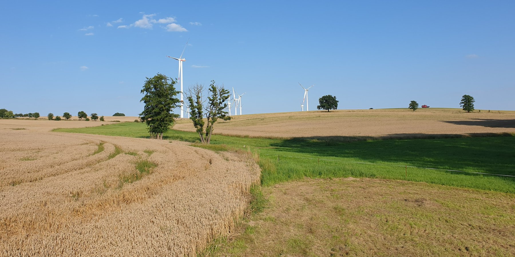
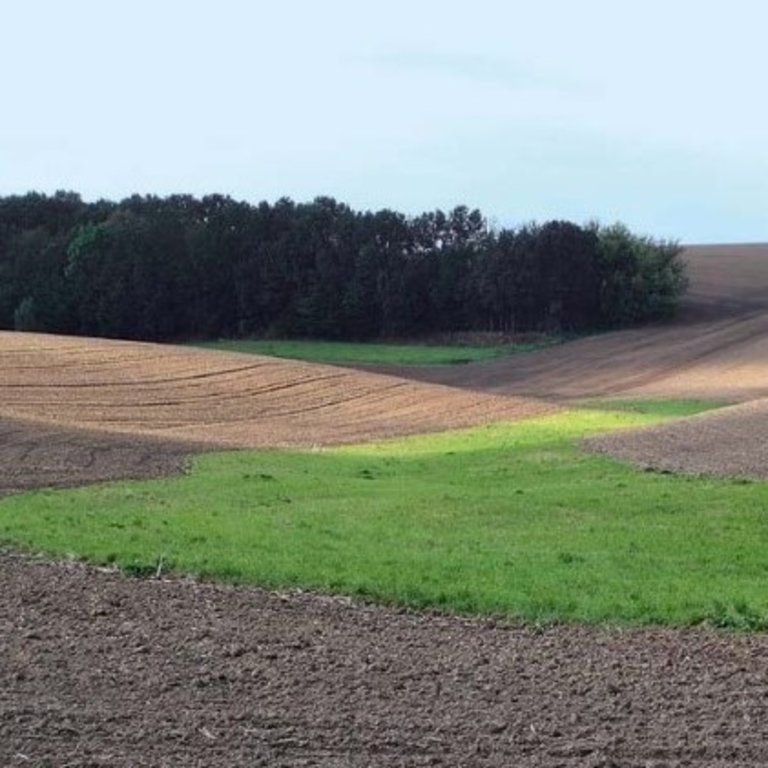
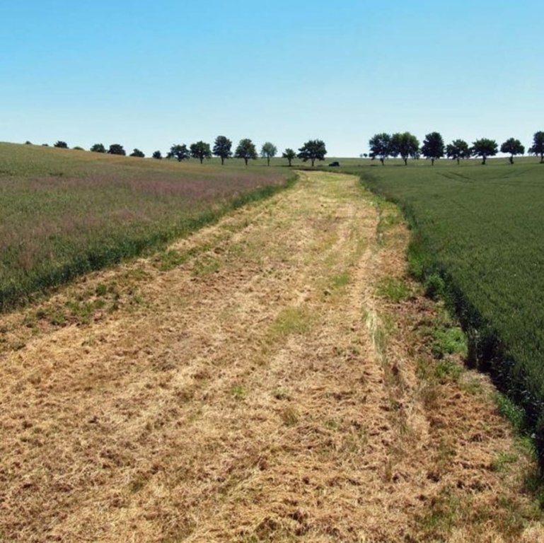
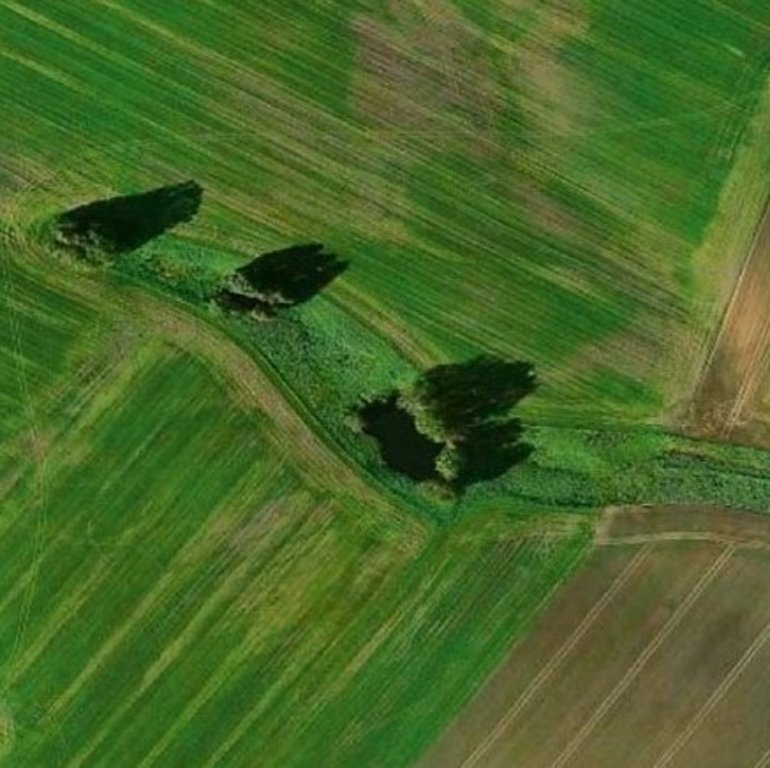
A grassed waterway is a strip of grass and other permanent low growing vegetation that is established along in the main drainage line (the thalweg) of an agricultural field to discharge water safely and prevent gully development.
2.2 ການອະທິບາຍ ລາຍລະອຽດ ຂອງເຕັກໂນໂລຢີ
ການພັນລະນາ:
In order to prevent gully erosion along main drainage lines (thalwegs), grassed waterways, composed of grass and other permanent low growing vegetation, are established to discharge water safely. The grassed waterway slows down the surface runoff in the thalweg, increases infiltration and stabilizes the soil surface. This reduces soil erosion by water and the associated runoff of nutrients and pesticides. Fiener et al. (2005) reported a sediment retention of 80-95% and a water retention of 70-90%. Sediment is trapped mainly by water infiltration (infiltration-induced sedimentation) rather than by the filtering effect of vegetation. The conservation value of grassed waterways is not as high as for other measures, but they are still considered as a biotope network as well as a habitat for grassland breeders when extensive management practices are used (LfULG, 2010).
Grassed waterways are typically installed in relatively large arable fields. Normally only the most vulnerable lowest area of the field needs to be grassed. The width of the area to be grassed depends on the size of the drained catchment, the physiographic characteristics of the discharge pathway (channel shape, bottom slope) and the land management (e.g. working width of the agricultural machinery). The United States Department of Agriculture (2020) recommends a total width of the grassed waterway of about 6 m in the upper part and 15 m in the lower part. On average, a grassed waterway should occupy 2% of the catchment area (LfULG, 2015).
During the establishment of the vegetation, it is recommended to protect and stabilize the young plants against strong water flows, by temporary measures such as silt fences or mulching. Once the vegetation is dense enough to withstand heavy rain events, these temporary measures should be removed. After each heavy rainfall event, the waterway should be inspected for damage. Damaged areas should be filled and reseeded, and sediment deposits should be removed.
The choice of the seed mixture depends on the intended use and maintenance of the grassed waterway. A combination of trees and grass increases infiltration rates and natural values. Mowing should be done at least once a year, otherwise, shrubs will establish and suppress the grass. The grassed waterway should not be used as a track for vehicles because of soil compaction, and damage to vegetation. Where possible, tillage should be across the slope – therefore perpendicular to the grassed waterway in order to avoid furrows developing parallel to the waterway. A combination with conservation tillage or other erosion control practices is highly recommended (LfULG, 2010).
Grassed waterways involve a permanent change in land-use, which means a loss of cultivable area, and associated loss of yield - and of income too if it is not covered by subsidies. Many land users dislike such structures in their fields as they impede machinery. Because land users are not always the landowners, they are not always allowed to make permanent changes in land-use. In Germany, a grassland becomes permanent after 5 years. Thus, many farmers decide to plough and replant such grassed areas every 5 years.
The landowner in our documentation had suffered from lodging of his oat crop along the drainage path due to heavy rainfall. Thus, he decided to undesow the oats with ryegrass. In the following year, the undersown ryegrass developed better than the oats and the farmer decided to establish ryegrass as the main crop over the whole field – rather then just in the thalweg, to avoid having to drive around it. Now he mows the area once in the spring for silage and then uses it as pasture for his horses. Every five years, he has to plough the whole area and replant it with ryegrass to prevent it from becoming permanent grassland.
2.3 ຮູບພາບຂອງເຕັກໂນໂລຢີ
2.5 ປະເທດ / ເຂດ / ສະຖານທີ່ບ່ອນທີ່ ເຕັກໂນໂລຢີ ໄດ້ຮັບການນໍາໃຊ້ ແລະ ທີ່ຖືກປົກຄຸມດ້ວຍການປະເມີນຜົນ
ປະເທດ:
ເຢຍລະມັນ
ພາກພື້ນ / ລັດ / ແຂວງ:
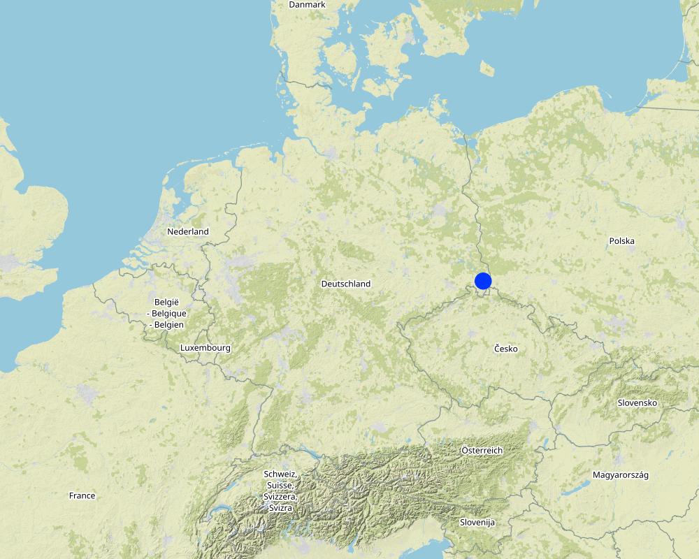
Saxony
ໃຫ້ລະບຸ ການແຜ່ຂະຫຍາຍ ເຕັກໂນໂລຢີ:
- ນໍາໃຊ້ໃນຈຸດສະເພາະ / ແນໃສ່ນໍາໃຊ້ໃນພື້ນທີ່ຂະໜາດນ້ອຍ
ສ່ວນຫຼາຍສະຖານທີ່ຕັ້ງຂອງເຕັກໂນໂລຢີ ແມ່ນ ຢູ່ໃນເຂດພື້ນທີ່ສະຫງວນບໍ?
ບໍ່ແມ່ນ
Map
×2.6 ວັນທີໃນການຈັດຕັ້ງປະຕິບັດ
ໃຫ້ລະບຸປີ ໃນການຈັດຕັ້ງປະຕິບັດ:
2022
ຖ້າຫາກວ່າ ບໍ່ຮູ້ຈັກ ປີທີ່ຊັດເຈນ ແມ່ນໃຫ້ປະມານ ວັນທີເອົາ:
- ຕໍ່າກວ່າ 10 ປີ ຜ່ານມາ (ມາເຖິງປະຈຸບັນ)
2.7 ການນໍາສະເໜີ ເຕັກໂນໂລຢີ
ໃຫ້ລະບຸ ເຕັກໂນໂລຢີ ໄດ້ຖືກຈັດຕັ້ງປະຕິບັດຄືແນວໃດ?
- ໂດຍຜ່ານນະວັດຕະກໍາຄິດຄົ້ນຂອງຜູ້ນໍາໃຊ້ທີ່ດິນ
ຄວາມຄິດເຫັນ (ປະເພດ ໂຄງການ ແລະ ອື່ນໆ):
Initially, perennial ryegrass was used as an undersown crop to oats as a greening requirement of German agricultural policy. Later, the farmer decided to establish ryegrass as the main crop, including the discharge pathway.
3. ການໃຈ້ແຍກ ເຕັກໂນໂລຢີ ໃນການຄຸ້ມຄອງ ດິນແບບຍືນຍົງ
3.1 ຈຸດປະສົງຫຼັກ (ຫຼາຍ) ຂອງເຕັກໂນໂລຢີ
- ຫຼຸດຜ່ອນ, ປ້ອງກັນ, ຟື້ນຟູ ການເຊື່ອມໂຊມຂອງດິນ
- ປົກປັກຮັກສານໍ້າ / ນໍ້າພື້ນທີ່ - ປະສົມປະສານກັບ ເຕັກໂນໂລຢີອື່ນໆ
- ປົກປັກຮັກສາ / ການປັບປຸງຊີວະນາໆພັນ
- ປັບຕົວຕໍ່ກັບການປ່ຽນແປງດິນຟ້າອາກາດ / ທີ່ຮ້າຍແຮງ ແລະ ຜົນກະທົບ
3.2 ປະເພດການນໍາໃຊ້ທີ່ດິນ ໃນປະຈຸບັນ() ທີ່ເຕັກໂນໂລຢີ ໄດ້ຖືກນໍາໃຊ້
ການນຳໃຊ້ທີ່ດິນ ປະສົມພາຍໃນພື້ນທີ່ດຽວກັນ:
ແມ່ນ
ລະບຸການນຳໃຊ້ທີ່ດິນແບບປະສົມ (ຜົນລະປູກ / ທົ່ງຫຍ້າລ້ຽງສັດ / ຕົ້ນໄມ້):
- ກະສິກໍາແບບປະສົມປະສານ (ລວມທັງ ການລ້ຽງສັດ-ປຸກຝັງ)

ດິນທີ່ປູກພືດ
- ການປູກພືດປະຈໍາປີ
ການປູກພືດປະຈຳປີ - ລະບຸປະເພດພືດ:
- ພືດອາຫານສັດ-ປະເພດຫຍ້າ
- german rye grass
ຈໍານວນ ລະດູການ ປູກໃນປີໜຶ່ງ:
- 1
ລະບຸ ຊະນິດ:
one mowing per year for silage
ມີການເຝືກປູກພືດແບບສັບຫວ່າງບໍ່?
ບໍ່ແມ່ນ
ມີການເຝືກປູກພືດແບບໝູນວຽນບໍ່?
ບໍ່ແມ່ນ

ທົ່ງຫຍ້າລ້ຽງສັດ
ທົ່ງຫຍ້າລ້ຽງສັດແບບສຸມ / ການຜະລິດອາຫານສັດ:
- ປັບປຸງ ທົ່ງຫຍ້າ
ປະເພດສັດ:
- ມ້າ
ແມ່ນການເຝືກຄຸ້ມຄອງ ການປູກພືດປະສົມປະສານ ກັບການລ້ຽງສັດບໍ່?
ແມ່ນ
ຖ້າແມ່ນ, ໃຫ້ລະບຸແຈ້ງ:
Using horse manure as fertilizer for the rye grass
ຜະລິດຕະພັນ ແລະ ການບໍລິການ:
- manure as fertilizer/ energy production
ສາຍພັນ:
ມ້າ
ນັບ:
2
ຄວາມຄິດເຫັນ:
The actual use of the grassed waterway can be very different and also depends on its dimensions. In the documented example the grassed waterway was partially used for extensive grazing (horses).
3.3 ການນຳໃຊ້ທີ່ດິນ ມີການປ່ຽນແປງຍ້ອນການຈັດຕັ້ງທົດລອງເຕັກໂນໂລຢີ ແມ່ນບໍ່?
ການນຳໃຊ້ທີ່ດິນ ມີການປ່ຽນແປງຍ້ອນການຈັດຕັ້ງທົດລອງເຕັກໂນໂລຢີ ແມ່ນບໍ່?
- ແມ່ນ (ກະລຸນາຕື່ມໃສ່ ຄຳຖາມຂ້າງລຸ່ມນີ້ກ່ຽວກັບການນຳໃຊ້ທີ່ດິນ ກ່ອນການທົດລອງເຕັກໂນໂລຢີ)
ການນຳໃຊ້ທີ່ດິນ ປະສົມພາຍໃນພື້ນທີ່ດຽວກັນ:
ບໍ່ແມ່ນ

ດິນທີ່ປູກພືດ
- ການປູກພືດປະຈໍາປີ
ການປູກພືດປະຈຳປີ - ລະບຸປະເພດພືດ:
- ທັນຍາພືດ-ເຂົ້າໂອດ
ມີການເຝືກປູກພືດແບບສັບຫວ່າງບໍ່?
ແມ່ນ
ຖ້າມີ, ໃຫ້ລະບຸວ່າປູກພືດຊະນິດໃດທີ່ປູກສັບຫວ່າງ:
german rye grass
ມີການເຝືກປູກພືດແບບໝູນວຽນບໍ່?
ບໍ່ແມ່ນ
3.4 ການສະໜອງນ້ຳ
ການສະໜອງນໍ້າ ໃນພື້ນທີ່ ທີ່ໄດ້ນໍາໃຊ້ ເຕັກໂນໂລຢີ:
- ນໍ້າຝົນ
3.5 ການນໍາໃຊ້ເຕັກໂນໂລຢີ ທີ່ຢູ່ໃນກຸ່ມການຄຸ້ມຄອງ ທີ່ດິນແບບຍືນຍົງ
- ການປັບປຸງດິນ / ພືດຄຸມດິນ
- ຄວາມຫຼາກຫຼາຍຂອງນໍ້າ ແລະ ການລະບາຍ
3.6 ມາດຕະການ ການຄຸ້ມຄອງ ທີ່ດິນແບບຍືນຍົງ ປະກອບດ້ວຍ ເຕັກໂນໂລຢີ

ມາດຕະການ ທາງດ້ານພືດພັນ
- V2: ຫຍ້າ ແລະ ພືດສະໝູນໄພທີ່ເປັນໄມ້ຢືນຕົ້ນ
3.7 ປະເພດດິນເຊື່ອມໂຊມ ຫຼັກທີ່ໄດ້ນໍາໃຊ້ ເຕັກໂນໂລຢີ

ດິນເຊາະເຈື່ອນ ໂດຍນໍ້າ
- Wt: ການສູນເສຍຊັ້ນໜ້າດິນ / ການເຊາະເຈື່ອນຜິວໜ້າດິນ
- Wg: ການເຊາະເຈື່ອນຮ່ອງນ້ຳ / ຫ້ວຍ

ດິນເຊາະເຈື່ອນ ໂດຍລົມ
- ການສູນເສຍຊັ້ນໜ້າດິນ

ການເຊື່ອມໂຊມ ຂອງດິນ ທາງເຄມີ
- Cn: ຄວາມອຸດົມສົມບູນ ລົດໜ້ອຍຖອຍລົງ ແລະ ສານອິນຊີວັດຖຸລົດລົງ (ບໍ່ແມ່ນສາເຫດມາຈາກການເຊາະເຈື່ອນ)

ການເຊື່ອມໂຊມ ຂອງດິນ ທາງກາຍະພາບ
- Pc: ການອັດແໜ້ນ
- Pk: ການບັນເທົາ ແລະ ການປົກຄຸມຂອງເປືອກໂລກ

ການເຊື່ອມໂຊມ ທາງຊີວະພາບ
- Bc: ການຫຼຸດຜ່ອນການປົກຫຸ້ມຂອງພືດ
- Bh: ການສູນເສຍ ທີ່ຢູ່ອາໃສ ຂອງສິ່ງທີ່ມີຊິວິດ
- Bl: ການສູນເສຍ ຈຸລິນຊີໃນດິນ

ການເຊື່ອມໂຊມ ຂອງນໍ້າ
- Hs: ການປ່ຽນແປງ ປະລິມານ ນໍ້າໜ້າດິນ
3.8 ການປ້ອງກັນ, ການຫຼຸດຜ່ອນ, ຫຼືການຟື້ນຟູຂອງການເຊື່ອມໂຊມຂອງດິນ
ໃຫ້ລະບຸ ເປົ້າໝາຍ ເຕັກໂນໂລຢີ ທີ່ພົວພັນ ກັບຄວາມເຊື່ອມໂຊມຂອງດິນ:
- ປ້ອງກັນການເຊື່ອມໂຊມຂອງດິນ
- ຫຼຸດຜ່ອນການເຊື່ອມໂຊມຂອງດິນ
4. ຂໍ້ກໍາໜົດ, ກິດຈະກໍາການປະຕິບັດ, ວັດຖຸດິບ, ແລະຄ່າໃຊ້ຈ່າຍ
4.1 ເຕັກນິກ ໃນການແຕ້ມແຜນວາດ ເຕັກໂນໂລຢີ
ຄຸນລັກສະນະ ຂອງເຕັກນິກ (ທີ່ກ່ຽວຂ້ອງ ກັບການແຕ້ມແຜນວາດ ທາງດ້ານເຕັກນີກ):
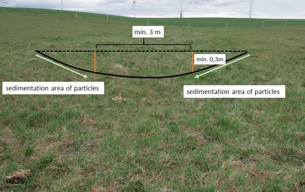
Normally, only the vulnerable lowest area of an agricultural field ( channel shape, bottom slope) needs to be grassed. LfULG recommends 1-4 m wide side slopes with a passable gradient of 1:10 (10%) and a total width of the upper slope of about 6 m and 15 m for the lower slope. The bottom of the drainage channel must be at least 3 m wide and 0.3 m deep. The side slopes are responsible for sedimentation of particles and the bottom for infiltration of water.
ຜູ້ຂຽນ:
Mona Pauer based on LfULG 2010, p.27
ວັນທີ:
23/03/2023
ຄຸນລັກສະນະ ຂອງເຕັກນິກ (ທີ່ກ່ຽວຂ້ອງ ກັບການແຕ້ມແຜນວາດ ທາງດ້ານເຕັກນີກ):
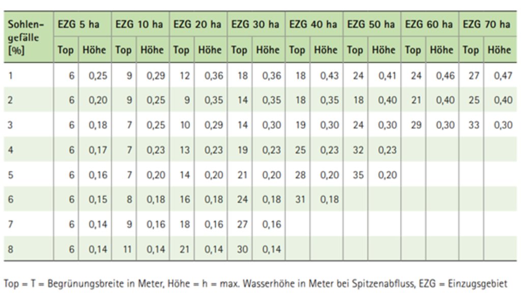
Guide values for the width (Top) of drainage channels depending on the size of the catchment area (EZG), the slope of the riverbed (Sohlengefälle) and the height (Höhe) of the drainage channel.
ຜູ້ຂຽນ:
LfULG 2015, p. 7
ວັນທີ:
05/01/2015
4.2 ຂໍ້ມູນທົ່ວໄປກ່ຽວກັບການຄິດໄລ່ປັດໃຈຂາເຂົ້າໃນການຜະລິດ ແລະ ມູນຄ່າອື່ນໆ
ລະບຸ ວິທີການ ຄຳໃຊ້ຈ່າຍ ແລະ ປັດໄຈນໍາເຂົ້າ ທີ່ໄດ້ຄິດໄລ່:
- ຕໍ່ພື້ນທີ່ ທີ່ໄດ້ຈັດຕັ້ງປະຕິບັດ ເຕັກໂນໂລຢີ
ໃຫ້ລະບຸຫົວໜ່ວຍ ຂະໜາດ ແລະ ເນື້ອທີ່:
1 ha
ສະກຸນເງິນອື່ນໆ / ປະເທດອື່ນໆ (ລະບຸ):
€
ຖ້າກ່ຽວຂ້ອງ, ໃຫ້ລະບຸອັດຕາແລກປ່ຽນຈາກ USD ເປັນສະກຸນເງິນທ້ອງຖິ່ນ (ເຊັ່ນ: 1 USD = 79.9 Brazilian Real): 1 USD =:
0.91
ລະບຸ ຄ່າຈ້າງ ຄ່າແຮງງານສະເລ່ຍ ຕໍ່ ວັນ:
18.70 € per hour
4.3 ການສ້າງຕັ້ງກິດຈະກໍາ
| ກິດຈະກໍາ | Timing (season) | |
|---|---|---|
| 1. | reseeding of ryegrass (drill seed) | spring |
| 2. | rolling (soil contact between plant and soil) | spring |
4.4 ຕົ້ນທຶນ ແລະ ປັດໄຈຂາເຂົ້າທີ່ຈໍາເປັນໃນຈັດຕັ້ງປະຕິບັດ
| ລະບຸ ປັດໃຈ ນໍາເຂົ້າ ໃນການຜະລີດ | ຫົວໜ່ວຍ | ປະລິມານ | ຕົ້ນທຶນ ຕໍ່ຫົວໜ່ວຍ | ຕົ້ນທຶນທັງໝົດ ຂອງປັດໃຈຂາເຂົ້າ ໃນການຜະລິດ | % ຂອງຕົ້ນທຶນທັງໝົດ ທີ່ຜູ້ນໍາໃຊ້ທີ່ດິນ ໃຊ້ຈ່າຍເອງ | |
|---|---|---|---|---|---|---|
| ແຮງງານ | seeding | ha | 1.0 | 20.19 | 20.19 | 100.0 |
| ແຮງງານ | rolling | ha | 1.0 | 19.58 | 19.58 | 100.0 |
| ວັດສະດຸໃນການປູກ | seeds | ha | 1.0 | 32.4 | 32.4 | 100.0 |
| ຕົ້ນທຶນທັງໝົດ ໃນການຈັດຕັ້ງປະຕິບັດ ເຕັກໂນໂລຢີ | 72.17 | |||||
| ຄ່າໃຊ້ຈ່າຍທັງໝົດ ສຳລັບການສ້າງຕັ້ງເຕັກໂນໂລຢີ ເປັນສະກຸນເງີນໂດລາ | 79.31 | |||||
ຄວາມຄິດເຫັນ:
Based on a new subsidy programme (valid from 2023), the establishment and 5-year maintenance of a grassed waterways will be subsidised with 299€/ha in Saxony (Germany): https://www.smekul.sachsen.de/foerderung/download/Steckbrief_AL_1.pdf
This also partially compensates for the loss of yield and income.
4.5 ບໍາລຸງຮັກສາ / ແຜນຈັດຕັ້ງປະຕິບັດ ກິດຈະກໍາ
| ກິດຈະກໍາ | ໄລຍະເວລາ / ຄວາມຖີ່ | |
|---|---|---|
| 1. | mulching | every spring |
| 2. | ploughing | every 5 years |
| 3. | reseeding | every 5 years |
ຄວາມຄິດເຫັນ:
In Germany, grassland must be removed after 5 years (by ploughing or using chemicals) and then reseeded. Otherwise it becomes permanent grassland.
4.6 ຄ່າໃຊ້ຈ່າຍ ແລະ ປັດໄຈນໍາເຂົ້າທີ່ຈໍາເປັນສໍາລັບການບໍາລຸງຮັກສາກິດຈະກໍາ / ແຜນປະຕິບັດ (ຕໍ່ປີ)
| ລະບຸ ປັດໃຈ ນໍາເຂົ້າ ໃນການຜະລີດ | ຫົວໜ່ວຍ | ປະລິມານ | ຕົ້ນທຶນ ຕໍ່ຫົວໜ່ວຍ | ຕົ້ນທຶນທັງໝົດ ຂອງປັດໃຈຂາເຂົ້າ ໃນການຜະລິດ | % ຂອງຕົ້ນທຶນທັງໝົດ ທີ່ຜູ້ນໍາໃຊ້ທີ່ດິນ ໃຊ້ຈ່າຍເອງ | |
|---|---|---|---|---|---|---|
| ແຮງງານ | mulching | ha | 1.0 | 24.87 | 24.87 | 100.0 |
| ແຮງງານ | ploughing | ha | 0.2 | 63.56 | 12.71 | 100.0 |
| ແຮງງານ | reseeding | ha | 0.2 | 39.77 | 7.95 | 100.0 |
| ວັດສະດຸໃນການປູກ | seeds | 32,4 | 0.2 | 32.4 | 6.48 | 100.0 |
| ຕົ້ນທຶນທັງໝົດ ທີ່ໃຊ້ໃນການບໍາລຸງຮັກສາ ເຕັກໂນໂລຢີ | 52.01 | |||||
| ຄ່າໃຊ້ຈ່າຍທັງໝົດ ສຳລັບການບົວລະບັດຮກສາເຕັກໂນໂລຢີ ເປັນສະກຸນເງີນໂດລາ | 57.15 | |||||
ຄວາມຄິດເຫັນ:
Maintenance costs related to ploughing and reseeding are only required every five years. Therefore, they are based on the implementation costs and divided by 5.
4.7 ປັດໄຈ ທີ່ສໍາຄັນ ທີ່ສົ່ງຜົນກະທົບ ຕໍ່ຄ່າໃຊ້ຈ່າຍ
ໃຫ້ອະທິບາຍ ປັດໃຈ ທີ່ສົ່ງຜົນກະທົບ ຕໍ່ຕົ້ນທຶນ ໃນການຈັດຕັ້ງປະຕິບັດ:
Landowners complained that the additional yield (grass as fodder) would have no impact on their income. The loss of income due to the loss of arable land is greater and should be compensated by subsidy programs.
5. ສະພາບແວດລ້ອມທໍາມະຊາດ ແລະ ມະນຸດ
5.1 ອາກາດ
ປະລິມານນໍ້າຝົນປະຈໍາປີ
- < 250 ມີລິແມັດ
- 251-500 ມີລິແມັດ
- 501-750 ມີລິແມັດ
- 751-1,000 ມີລິແມັດ
- 1,001-1,500 ມີລິແມັດ
- 1,501-2,000 ມີລິແມັດ
- 2,001-3,000 ມີລິແມັດ
- 3,001-4,000 ມີລິແມັດ
- > 4,000 ມີລິແມັດ
ໃຫ້ລະບຸສະເລ່ຍ ປະລິມານນໍ້າຝົນຕົກປະຈໍາປີ ເປັນມິນລິແມັດ (ຖ້າຫາກຮູ້ຈັກ):
775.00
ໃຫ້ລະບຸ ຊື່ສະຖານີ ອຸຕຸນິຍົມ ເພື່ອເປັນຂໍ້ມູນອ້າງອີງ:
https://whh-kliwes.de/mapview
ເຂດສະພາບອາກາດກະສິກໍາ
- ເຄີ່ງຄວາມຊຸ່ມ
LGP: 209 days (https://www.umwelt.sachsen.de/dauer-der-vegetationsperiode-30631.html)
5.2 ພູມິປະເທດ
ຄ່າສະເລ່ຍ ຄວາມຄ້ອຍຊັນ:
- ພື້ນທີ່ຮາບພຽງ (0-2%)
- ອ່ອນ (3-5 %)
- ປານກາງ (6-10 %)
- ມ້ວນ (11-15 %)
- ເນີນ(16-30%)
- ໍຊັນ (31-60%)
- ຊັນຫຼາຍ (>60%)
ຮູບແບບຂອງດິນ:
- ພູພຽງ / ທົ່ງພຽງ
- ສັນພູ
- ເປີ້ນພູ
- ເນີນພູ
- ຕີນພູ
- ຮ່ອມພູ
ເຂດລະດັບສູງ:
- 0-100 ແມັດ a.s.l.
- 101-500 ແມັດ a.s.l.
- 501-1,000 ແມັດ a.s.l.
- 1,001-1,500 ແມັດ a.s.l.
- 1,501-2,000 ແມັດ a.s.l.
- 2,001-2,500 ແມັດ a.s.l.
- 2,501-3,000 ແມັດ a.s.l.
- 3,001-4,000 ແມັດ a.s.l.
- > 4,000 ແມັດ a.s.l.
ໃຫ້ລະບຸ ເຕັກໂນໂລຢີ ທີ່ໄດ້ຖືກນຳໃຊ້:
- ລັກສະນະກີ່ວ
ຄຳເຫັນ ແລະ ຂໍ້ມູນສະເພາະ ເພີ່ມເຕີມ ກ່ຽວກັບ ພູມີປະເທດ:
A grassed waterway is a strip of grassland (permanent vegetation close to the ground) established in the line of the lowest elevation (thalweg) of an agricultural field.
5.3 ດິນ
ຄວາມເລິກ ຂອງດິນສະເລ່ຍ:
- ຕື້ນຫຼາຍ (0-20 ຊັງຕີແມັດ)
- ຕື້ນ (21-50 ຊຕມ)
- ເລີກປານກາງ (51-80 ຊຕມ)
- ເລິກ (81-120 ຊມ)
- ເລິກຫຼາຍ (> 120 cm)
ເນື້ອດິນ (ໜ້າດິນ):
- ຫຍາບ / ເບົາ (ດິນຊາຍ)
- ປານກາງ (ດິນໜຽວ, ດິນໂຄນ)
ເນື້ອດິນ (ເລິກຈາກໜ້າດິນ ລົງໄປຫຼາຍກວ່າ 20 ຊັງຕິແມັດ):
- ປານກາງ (ດິນໜຽວ, ດິນໂຄນ)
ຊັ້ນອິນຊີວັດຖຸ ເທິງໜ້າດິນ:
- ປານກາງ (1-3 %)
ຖ້າເປັນໄປໄດ້ ແມ່ນໃຫ້ຕິດຄັດ ການພັນລະນາດິນ ຫຼື ຂໍ້ມູນສະເພາະຂອງດິນ, ຕົວຢ່າງ, ຄຸນລັກສະນະ ປະເພດຂອງດິນ, ຄ່າຄວາມເປັນກົດ / ເປັນດ່າງຂອງດິນ, ສານອາຫານ, ດິນເຄັມ ແລະ ອື່ນໆ.
Luvisol (German soil classification system: Pseudogley Parabraunerde)
5.4 ມີນໍ້າ ແລະ ຄຸນນະພາບ
ລະດັບ ນໍ້າໃຕ້ດິນ:
< 5 ແມັດ
ການມີນໍ້າ ເທິງໜ້າດິນ:
ທຸກຍາກ / ບໍ່ມີ
ຄຸນນະພາບນໍ້າ (ບໍ່ມີການບໍາບັດ):
ບໍ່ມີນໍ້າດື່ມ (ຮຽກຮ້ອງໃຫ້ມີການບຳບັດນ້ຳ)
ຄຸນນະພາບນ້ຳ ໝາຍເຖີງ:
ນ້ຳໜ້າດິນ
ມີບັນຫາ ກ່ຽວກັບນໍ້າເຄັມບໍ່?
ບໍ່ແມ່ນ
ເກີດມີນໍ້າຖ້ວມ ໃນພື້ນທີ່ບໍ່?
ບໍ່ແມ່ນ
ຄວາມຄິດເຫັນ ແລະ ຂໍ້ກໍານົດ ເພີ່ມເຕີມ ກ່ຽວກັບ ຄຸນນະພາບ ແລະ ປະລິມານ ຂອງນ້ຳ:
Heavy rainfall events cause flooding in the thalweg and erosion on the hillsides of the arable land. The field with the grassed waterway has had repeated erosion problems, with soil material being washed onto the adjacent road.
5.5 ຊີວະນາໆພັນ
ຄວາມຫຼາກຫຼາຍ ທາງສາຍພັນ:
- ຕໍ່າ
ຄວາມຫຼາກຫຼາຍ ທາງດ້ານ ທີ່ຢູ່ອາໃສ ຂອງສິ່ງທີ່ມີຊີວິດ:
- ຕໍ່າ
ຄວາມຄິດເຫັນ ແລະ ລັກສະນະສະເພາະ ເພີ່ມເຕີມກ່ຽວກັບ ຊີວະນາໆພັນ:
Only one species is planted, but compared to oats, long-term grassland provides higher habitat quality and slightly higher biodiversity. The presence of shrubs and trees in the grassed waterway can further increase habitat diversity and species variety.
5.6 ຄຸນລັກສະນະ ຂອງຜູ້ນໍາໃຊ້ທີ່ດິນ ທີ່ໄດ້ນໍາໃຊ້ເຕັກໂນໂລຢີ
ຢູ່ປະຈຳ ຫຼື ເຄື່ອນຍ້າຍຕະຫຼອດ:
- ບໍ່ເຄື່ອນໄຫວ
ລະບົບ ການຕະຫຼາດ ແລະ ຜົນຜະລິດ:
- ການຄ້າ / ຕະຫຼາດ
ລາຍຮັບ ທີ່ບໍ່ໄດ້ມາຈາກ ການຜະລິດ ກະສິກໍາ:
- ໜ້ອຍກ່ວາ 10 % ຂອງລາຍຮັບທັງໝົດ
ລະດັບຄວາມຮັ່ງມີ:
- ສະເລ່ຍ
ບຸກຄົນ ຫຼື ກຸ່ມ:
- ບຸກຄົນ / ຄົວເຮືອນ
ລະດັບ ການຫັນເປັນກົນຈັກ:
- ເຄື່ອງກົນຈັກ
ເພດ:
- ຜູ້ຍິງ
- ຜູ້ຊາຍ
ອາຍຸ ຂອງຜູ້ນໍາໃຊ້ທີ່ດິນ:
- ໄວກາງຄົນ
ໃຫ້ລະບຸ ຄຸນລັກສະນະ ຂອງຜູ້ນໍາໃຊ້ທີ່ດິນ:
The landowner's son is studying agriculture, and the father is open to trying out the new knowledge on his land.
5.7 ເນື້ອທີ່ສະເລ່ຍຂອງດິນ ທີ່ຜູ້ນຳໃຊ້ທີ່ດິນ ໃຊ້ເຮັດເຕັກໂນໂລຢີ
- <0.5 ເຮັກຕາ
- 0.5-1 ເຮັກຕາ
- 1-2 ເຮັກຕາ
- 2-5 ເຮັກຕາ
- 5-15 ເຮັກຕາ
- 15-50 ເຮັກຕາ
- 50-100 ເຮັກຕາ
- 100-500 ເຮັກຕາ
- 500-1,000 ເຮັກຕາ
- 1,000-10,000 ເຮັກຕາ
- > 10,000 ເຮັກຕາ
ຖືໄດ້ວ່າ ເປັນຂະໜາດນ້ອຍ, ກາງ ຫຼື ໃຫຍ່ (ອີງຕາມເງື່ອນໄຂ ສະພາບຄວາມເປັນຈິງ ຂອງທ້ອງຖີ່ນ)? :
- ຂະໜາດນ້ອຍ
5.8 ເຈົ້າຂອງທີ່ດິນ, ສິດໃຊ້ທີ່ດິນ, ແລະ ສິດທິການນໍາໃຊ້ນໍ້າ
ເຈົ້າຂອງດິນ:
- ບຸກຄົນ, ບໍ່ມີຕໍາແໜ່ງ
ສິດທິ ໃນການນໍາໃຊ້ທີ່ດິນ:
- ເຊົ່າ
- ບຸກຄົນ
ສິດທິ ໃນການນໍາໃຊ້ນໍ້າ:
- ຊຸມຊົນ (ທີ່ມີການຈັດຕັ້ງ)
ສິດນຳໃຊ້ທີ່ດິນ ແມ່ນ ອີງໃສ່ລະບົບກົດໝາຍແບບດັ້ງເດີມບໍ?
ບໍ່ແມ່ນ
5.9 ການເຂົ້າເຖິງການບໍລິການ ແລະ ພື້ນຖານໂຄງລ່າງ
ສຸຂະພາບ:
- ທຸກຍາກ
- ປານກາງ
- ດີ
ການສຶກສາ:
- ທຸກຍາກ
- ປານກາງ
- ດີ
ການຊ່ວຍເຫຼືອ ດ້ານວິຊາການ:
- ທຸກຍາກ
- ປານກາງ
- ດີ
ການຈ້າງງານ (ຕົວຢ່າງ, ການເຮັດກິດຈະກໍາອື່ນ ທີ່ບໍ່ແມ່ນ ການຜະລິດກະສິກໍາ):
- ທຸກຍາກ
- ປານກາງ
- ດີ
ຕະຫຼາດ:
- ທຸກຍາກ
- ປານກາງ
- ດີ
ພະລັງງານ:
- ທຸກຍາກ
- ປານກາງ
- ດີ
ຖະໜົນຫົນທາງ ແລະ ການຂົນສົ່ງ:
- ທຸກຍາກ
- ປານກາງ
- ດີ
ການດື່ມນໍ້າ ແລະ ສຸຂາພິບານ:
- ທຸກຍາກ
- ປານກາງ
- ດີ
ການບໍລິການ ທາງດ້ານການເງິນ:
- ທຸກຍາກ
- ປານກາງ
- ດີ
6. ຜົນກະທົບ ແລະ ລາຍງານສະຫຼຸບ
6.1 ການສະແດງຜົນກະທົບ ພາຍໃນພື້ນທີ່ ທີ່ໄດ້ຈັດຕັ້ງປະຕິບັດ ເຕັກໂນໂລຢີ
ຜົນກະທົບທາງເສດຖະກິດສັງຄົມ
ການຜະລິດ
ການຜະລິດອາຫານສັດ
ຄວາມຄິດເຫັນ / ລະບຸແຈ້ງ:
The loss of arable land (used for forage oats) cannot be compensated by harvesting grass on the runoff path.
ຄຸນນະພາບຂອງອາຫານສັດ
ຄວາມສ່ຽງ ຕໍ່ຜົນຜະລິດ
ເນື້ອທີ່ການຜະລິດ
ຄວາມຄິດເຫັນ / ລະບຸແຈ້ງ:
Measure does not affect yield, but means a loss of area.
ລາຍໄດ້ ແລະ ຄ່າໃຊ້ຈ່າຍ
ຄ່າໃຊ້ຈ່າຍ ປັດໄຈນໍາເຂົ້າ ໃນການຜະລິດກະສິກໍາ
ຄວາມຄິດເຫັນ / ລະບຸແຈ້ງ:
Costs for seeds
ລາຍຮັບ ຈາກການຜະລີດ
ຄວາມຫຼາກຫຼາຍ ຂອງແຫຼ່ງລາຍຮັບ
ມີວຽກໜັກ
ຄວາມຄິດເຫັນ / ລະບຸແຈ້ງ:
If a whole field is converted to a grassed waterway workload decreases. However, for a typical grassed waterway (just greening of the thalweg) an increase in workload can be expected.
ຜົນກະທົບຕໍ່ລະບົບນິເວດ
ວົງຈອນນໍ້າ / ນໍ້າ
ການໄຫຼ ຂອງນໍ້າໜ້າດິນ
ຄວາມຄິດເຫັນ / ລະບຸແຈ້ງ:
Reduction in surface water runoff.
ດິນ
ຄວາມຊຸ່ມຂອງດິນ
ການປົກຄຸມຂອງດິນ
ການສູນເສຍດິນ
ການທັບຖົມຂອງດິນ
ການອັດແໜ້ນຂອງດິນ
ອິນຊີວັດຖຸໃນດິນ / ຢູ່ລຸ່ມຊັ້ນດິນ C
ຊີວະນານາພັນ: ສັດ, ພືດ
ການປົກຫຸ້ມຂອງພືດ
ຄວາມຫຼາກຫຼາຍຂອງພືດ
ສາຍພັນຕ່າງຖີ່ນ
ຄວາມຫຼາກຫຼາຍ ທາງດ້ານທີ່ຢູ່ອາໃສ ຂອງສິ່ງທີ່ມີຊີວິດ
ການຄວບຄຸມສັດຕູພືດ / ພະຍາດ
ການຫຼຸດຜ່ອນ ຄວາມສ່ຽງ ຈາກໄພພິບັດ ແລະ ອາກາດປ່ຽນແປງ
ຜົນກະທົບ ຂອງໄພແຫ້ງແລ້ງ
ລະບຸ ການປະເມີນຜົນກະທົບ ຕໍ່ສະຖານທີ່ (ການວັດແທກ):
The reported on-site impacts are estimates of the respondents and are not based on measurements.
6.2 ຜົນກະທົບທາງອ້ອມ ຈາກການນໍາໃຊ້ເຕັກໂນໂລຢີ
ສາມາດເຂົ້າເຖິງແຫຼ່ງນໍ້າ
ມົນລະພິດ ທາງນໍ້າ / ນໍ້າໄຕ້ດິນ
ການປ້ອງກັນ / ຄວາມອາດສາມາດ ການກັ່ນຕອງ
ພື້ນທີ່ທໍາການຜະລິດ ຂອງເພື່ອນບ້ານທີ່ຢູ່ໃກ້ຄຽງ ໄດ້ຮັບຜົນກະທົບ
ຄວາມເສຍຫາຍ ກ່ຽວກັບພື້ນຖານໂຄງລ່າງ ສາທາລະນະ / ເອກກະຊົນ
ຄວາມຄິດເຫັນ / ລະບຸແຈ້ງ:
No more soil deposits in the yard/on the street.
ກໍານົດ ການປະເມີນ ຜົນກະທົບທາງນອກ (ການວັດແທກ):
The reported on-site impacts are estimates of the respondents and of the compilers. They are not based on local measurements.
6.3 ການປ້ອງກັນ ແລະ ຄວາມບອບບາງ ຂອງເຕັກໂນໂລຢິ ໃນການປ່ຽນແປງສະພາບດິນຟ້າອາກາດ ແລະ ກ່ຽວຂ້ອງກັບອາກາດທີ່ມີການປ່ຽນແປງທີ່ຮຸນແຮງ / ໄພພິບັດທາງທໍາມະຊາດ (ຮັບຮູ້ໄດ້ໂດຍຜູ້ນໍາໃຊ້ທີ່ດິນ)
ການປ່ຽນແປງດິນຟ້າອາກາດ ເທື່ອລະກ້າວ
ການປ່ຽນແປງດິນຟ້າອາກາດ ເທື່ອລະກ້າວ
| ລະດູການ | ເພີ່ມຂື້ນ ຫຼື ຫຼຸດລົງ | ການນໍາໃຊ້ ເຕັກໂນໂລຢີ ສາມາດ ຮັບມື ໄດ້ຄືແນວໃດ? | |
|---|---|---|---|
| ອຸນຫະພູມລະດູການ | ລະດູໃບໄມ້ປົ່ງ | ເພີ່ມຂື້ນ | ດີ |
ອາກາດ ທີ່ກ່ຽວພັນກັບຄວາມຮຸນແຮງ (ໄພພິບັດທາງທໍາມະຊາດ)
ໄພພິບັດທາງອຸຕຸນິຍົມ
| ການນໍາໃຊ້ ເຕັກໂນໂລຢີ ສາມາດ ຮັບມື ໄດ້ຄືແນວໃດ? | |
|---|---|
| ພະຍຸຝົນ | ດີ |
6.4 ການວິເຄາະຕົ້ນທຶນ ແລະ ຜົນປະໂຫຍດ
ຈະເຮັດປະໂຫຍດເພື່ອປຽບທຽບກັບຄ່າໃຊ້ຈ່າຍກັບສິ່ງກໍ່ສ້າງ (ຈາກທັດສະນະຂອງຜູ້ນຳໃຊ້ທີ່ດິນ) ໄດ້ແນວໃດ?
ຜົນຕອບແທນ ໃນໄລຍະສັ້ນ:
ຜົນກະທົບທາງລົບເລັກນ້ອຍ
ຜົນຕອບແທນ ໃນໄລຍະຍາວ:
ຜົນກະທົບທາງລົບເລັກນ້ອຍ
ຈະໄດ້ຮັບຜົນປະໂຫຍດເມື່ອປຽບທຽບກັບ / ຄ່າໃຊ້ຈ່າຍໃນການບຳລຸງຮັກສາທີເ່ກີດຂື້ນອິກ (ຈາກທັດສະນະຄະຕິຂອງຜູ້ນຳໃຊ້ທີ່ດິນ) ໄດ້ແນວໃດ?
ຜົນຕອບແທນ ໃນໄລຍະສັ້ນ:
ຜົນກະທົບທາງລົບເລັກນ້ອຍ
ຜົນຕອບແທນ ໃນໄລຍະຍາວ:
ຜົນກະທົບທາງລົບເລັກນ້ອຍ
6.5 ການປັບຕົວຮັບເອົາເຕັກໂນໂລຢີ
- ກໍລະນີດຽວ / ການທົດລອງ
ທັງໝົດນັ້ນ ແມ່ນໃຜ ໄດ້ປັບຕົວເຂົ້າ ໃນການນໍາໃຊ້ ເຕັກໂນໂລຢີ, ມີຈັກຄົນ ທີ່ສາມາດເຮັດເອງໄດ້, ຕົວຢ່າງ, ປາດສະຈາກ ການຊ່ວຍເຫຼືອ ທາງດ້ານອຸປະກອນ / ການຈ່າຍເປັນເງິນ?
- 91-100%
6.6 ການປັບຕົວ
ໄດ້ມີການດັດປັບ ເຕັກໂນໂລຢີ ເພື່ອໃຫ້ແທດເໝາະກັບເງື່ອນໄຂ ການປ່ຽນແປງບໍ?
ບໍ່ແມ່ນ
6.7 ຈຸດແຂງ / ຂໍ້ດີ / ໂອກາດ ໃນການນໍາໃຊ້ ເຕັກໂນໂລຢີ
| ຈຸດແຂງ / ຂໍ້ດີ / ໂອກາດໃນການນໍາໃຊ້ທີ່ດິນ |
|---|
| Compared to other erosion control measures, the area of the grassed waterway can continue to be used (extensively) for forage and grazing. |
| In Germany, the greened areas could be used as required greening areas for the direct payments of the agricultural policy. |
| ຈຸດແຂງ / ຈຸດດີ / ໂອກາດ ຈາກທັດສະນະຂອງຜູ້ປ້ອນຂໍ້ມູນ ຫຼື ບຸກຄົນສຳຄັນ |
|---|
| Grassed waterways are highly recommended and beneficial in preventing on-site gully erosion and off-site pollution of water bodies. |
| Due to their more technical background, the conservation value is not as high as for other measures, but they are still considered as a biotope network as well as a habitat for grassland breeders when extensively managed. |
6.8 ຈຸດອ່ອນ / ຂໍ້ເສຍ / ຄວາມສ່ຽງ ໃນການນໍາໃຊ້ ເຕັກໂນໂລຢີ ແລະ ວິທີການແກ້ໄຂບັນຫາ
| ຈຸດອ່ອນ / ຂໍ້ເສຍ / ຄວາມສ່ຽງໃນມຸມມອງຂອງຜູ້ນໍາໃຊ້ທີ່ດິນ | ມີວິທີການແກ້ໄຂຄືແນວໃດ? |
|---|---|
| In Germany, grassland becomes permanent if it is not converted within five years. This often leads to a conflict of interest between landowners and land-users. A permanent change in land-use (from arable land to permanent grassland) would mean a loss in land value. | As a result, the farmers plough and reseed the area after five years. With a change in regulations for certain measures, e.g. if land is used for nature conservation, it could remain cropland after five years without being converted. |
| A structure in the middle of a field is impractical in terms of tracks for machinery. | Sometimes it may be beneficial to green the entire field or subdivide the field with a linear structure. |
7. ເອກະສານອ້າງອີງ ແລະ ການເຊື່ອມຕໍ່
7.1 ວິທີການ / ແຫຼ່ງຂໍ້ມູນ
- ການໄປຢ້ຽມຢາມພາກສະໜາມ, ການສໍາຫຼວດພາກສະໜາມ
1
- ການສໍາພາດ ຜູ້ນໍາໃຊ້ທີ່ດິນ
1
- ການລວບລວມ ບົດລາຍງານ ແລະ ເອກະສານ ອື່ນໆ ທີ່ມີຢູ່ແລ້ວ
4
ເມື່ອໃດທີ່ໄດ້ສັງລວມຂໍ້ມູນ (ຢູ່ພາກສະໜາມ)?
23/03/2023
7.3 ເຊື່ອມຕໍ່ກັບຂໍ້ມູນທີ່ກ່ຽວຂ້ອງໂດຍກົງ
ຫົວຂໍ້ / ພັນລະນາ:
LfULG (2010): Erosionsschutz in reliefbedingten Abflussbahnen, Schriftenreihe, Heft 13
URL:
https://www.boden.sachsen.de/erosionsschutz-in-reliefbedingten-abflussbahnen-18074.html
ຫົວຂໍ້ / ພັນລະນາ:
United States Department of Agriculture (2020): Grassed Waterway - Conservation Practice Standard
URL:
https://www.nrcs.usda.gov/resources/guides-and-instructions/grassed-waterway-ac-412-conservation-practice-standard
ຫົວຂໍ້ / ພັນລະນາ:
LfULG (2015): Begrünung von erosionsgefährdeten Abflussbahnen. Broschüre
URL:
https://publikationen.sachsen.de/bdb/artikel/23739
ຫົວຂໍ້ / ພັນລະນາ:
Fiener & Auerswald (2006): Seasonal variation of grassed waterway effectiveness in reducing runoff and sediment delivery from agricultural watersheds in temperate Europe. Soil and Tillage Research 87, 48–58.
URL:
https://doi.org/10.1016/j.still.2005.02.035
ຫົວຂໍ້ / ພັນລະນາ:
Wasserhaushaltsportal Sachsen: KLiWES 2.1 IST-Zustand 1988-2015
URL:
https://whh-kliwes.de/mapview
ຂໍ້ມູນການເຊື່ອມຕໍ່ ແລະ ເນື້ອໃນ
ຂະຫຍາຍທັງໝົດ ຍຸບທັງໝົດການເຊື່ອມຕໍ່
ບໍ່ມີຂໍ້ມູນການເຊື່ອມຕໍ່
ເນື້ອໃນ
ບໍ່ມີເນື້ອໃນ


