Submerged drains [Нидерланд]
- Шинийг нээх:
- Шинэчлэх:
- Эмхэтгэгч: Simone Verzandvoort
- Хянан тохиолдуулагч: –
- Хянагч: Fabian Ottiger
Onderwaterdrains (NL)
technologies_1704 - Нидерланд
Бүлгүүдийг үзэх
Бүгдийг дэлгэх Бүгдийг хаах1. Ерөнхий мэдээлэл
1.2 Технологийг үнэлэх, баримтжуулах ажилд хамаарах мэдээлэл өгсөн хүмүүс, байгууллагуудын холбоо барих мэдээлэл
Мэдээлэл өгсөн хүн (с)
ГТМ мэргэжилтэн:
Van de Akker Jan J.H.
Wageningen Environmental Research (Alterra)
Droevendaalsesteeg, 6708 PB Wageningen, Niederlande
Нидерланд
ГТМ мэргэжилтэн:
Технологи баримтжуулах/үнэлэх ажилд дэмжлэг үзүүлсэн төслийн нэр (шаардлагатай бол)
Preventing and Remediating degradation of soils in Europe through Land Care (EU-RECARE )Технологи баримтжуулах/үнэлэх ажилд дэмжлэг үзүүлсэн байгууллага(ууд)-ын нэр (шаардлагатай бол)
Wageningen Environmental Research (Alterra) - НидерландТехнологи баримтжуулах/үнэлэх ажилд дэмжлэг үзүүлсэн байгууллага(ууд)-ын нэр (шаардлагатай бол)
Provincie Holland Zuid - НидерландТехнологи баримтжуулах/үнэлэх ажилд дэмжлэг үзүүлсэн байгууллага(ууд)-ын нэр (шаардлагатай бол)
Provincie Utrecht - НидерландТехнологи баримтжуулах/үнэлэх ажилд дэмжлэг үзүүлсэн байгууллага(ууд)-ын нэр (шаардлагатай бол)
LTO NOORD - НидерландТехнологи баримтжуулах/үнэлэх ажилд дэмжлэг үзүүлсэн байгууллага(ууд)-ын нэр (шаардлагатай бол)
Waterschap Amstel, Gooi en Vecht - Нидерланд1.3 ВОКАТ-аар баримтжуулсан өгөгдлийг ашиглахтай холбоотой нөхцөл
Мэдээллийг хэзээ (газар дээр нь) цуглуулсан бэ?
30/10/2015
Эмхэтгэгч болон гол мэдээлэгч хүн(хүмүүс) WOCAT аргачлалаар баримтжуулсан мэдээллийг ашиглахтай холбоотой нөхцлийг хүлээн зөвшөөрсөн:
Тийм
2. ГТМ Технологийн тодорхойлолт
2.1 Технологийн товч тодорхойлолт
Технологийн тодорхойлолт:
Submerged drains are drains installed in grassland on peatsoils with the aims to decrease soil subsidence and emission of CO2 and N2O due to the oxidation of peat soil, and to maintain suitable groundwater levels in fields for grassland production and grazing.
2.2 Технологийн дэлгэрэнгүй тодорхойлолт
Тодорхойлолт:
Contrary to usual drains, submerged drains are installed below ditchwater level. Submerged drains diminish the differences between ditch level and groundwater level in the fields by enabling the infiltration from ditch to field and the drainage from field to ditch.
In summer and dry periods the infiltration from ditch to field is much lower than the evapotranspiration of the grass, resulting in a lowering of the groundwater level some decimetres below ditch water level. With submerged drains the groundwater level is lowered less drastically because infiltration from ditch to field is improved. In winter and wet periods, fields are drained
more quickly compared to conventional drainage.
Purpose of the Technology: Submerged drains diminish the differences between ditch level and groundwater level in the fields by enabling the infiltration from ditch to field and the drainage from field to ditch. Under peak rainfall events groundwater levels become less high and remain at high levels for shorter times than in fields without submerged drains.
Due to the increased groundwater level in summer the decomposition of the peat soil is reduced. As a result, the rate of soil subsidence is decreased and also the emission of greenhouse gases and of N and P released to the surface water.
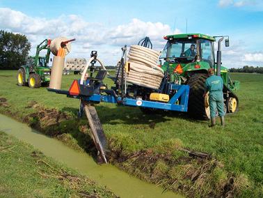
Establishment / maintenance activities and inputs: The installation of submerged drains is done with common drainage installation machines. Submerged drains should be installed between 15 and 25 cm below the ditch water level, and between 45 and 75 cm below the soil surface. The drain pipes should have a diameter of at least 6 cm. The distance between drains is at most 6 m. Drain length is at most 300 m. Submerged drains can be installed in the length or width direction of a field. Drains must be installed level.
Natural / human environment: Submerged drains were designed for peat soils under permanent pasture for dairy farming. More than 70 % of Dutch peat soils are under this land use. Drainage of these peat soils results in subsidence, mainly by decomposition (oxidation) of the peat (partly by shrinkage and consolidation). This is an ongoing process, because every 10 to 15 year ditchwater levels are adapted to the lowered surface in order to enable dairy farming and to prevent the conversion to wetlands. Soil subsidence causes several problems: decreased suitability for grazing and grassland farming, increased flood risk, emission of greenhouse gases, damage to infrastructure (dikes, roads, foundations, sewerage networks) and increased cost of water management.
Submerged drains were tested with a network of practitioners and 10 dairy farmers in the Dutch peat soil area between 2011 and 2013 on an area of 20 ha.
2.3 Технологийн гэрэл зураг
Медиа галерей
2.5 Энэ үнэлгээнд хамрагдсан технологийг хэрэгжүүлсэн улс орон/ бүс нутаг/ байршил
Улс:
Нидерланд
Улс/аймаг/сум:
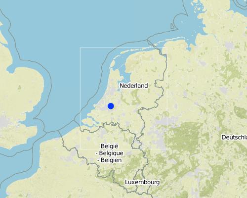
The Netherlands/Province of Zuid-Holland
Байршлын дэлгэрэнгүй тодорхойлолт:
Krimpenerwaard
Map
×2.6 Хэрэгжсэн хугацаа
Байгуулсан тодорхой оныг мэдэхгүй бол баримжаа хугацааг тодорхойл:
- <10 жилийн өмнө (саяхны)
2.7 Технологийн танилцуулга
Технологийг хэрхэн нэвтрүүлснийг тодорхойл:
- Туршилт/судалгааны үр дүн
- Гадны төсөл/хөтөлбөрийн дэмжлэгтэйгээр
- stimulated by regional authorities
Тайлбар (төслийн төрөл г.м.):
Since 2003 submerged drains have been applied on several experimental farms in The Netherlands. Implementations over larger areas (i.e. a water management unit, 'peilval' in Dutch) will be done in 2016.
2007: research on soil subsidence in the Western peat area following the large scale groundweter level lowering in the 1960s and 1970s signalled the high rate of soil subsidence (5-12 mm/y) (Van den Akker et al., 2007a)
2008: concerns about soil subsidence in the western peat area from the provincial autorities of Noord-Holland, Utrecht and Zuid-Holland in the policy document 'Voorloper Groene Hart' (2008)
2008-2012: various research projects to test the effectiveness of submerged drains to reduce soil subsidence and to improve conditions for dairy farming, and on the effects for water quality: www.waarheenmethetveen.nl, Hoving et al. (2008), Woestenburg (2009), EU project EUROPEAT, Woestenburg et al. 2009; Jansen et al., 2010; Hendriks and Van den Akker, 2012; Hoving et al. (2008, 2009, 2013)
2011-2012: research on the Peat Area Innovation Centre (VIC) to test effects of submerged drainage in combination with dynamic groundwater level management (Hoving et al., 2013)
2012- testing by research instsiutes of economic viability of submerged drains with regard to water level management and agricultural productivity, on assignment of the province Noord-Holland, waterboard Hollands Noorderkwartier.
2009-2011: various modelling studies assigned by the provinces and water boards of the western peat meadow area on the effects of submerged drains for the demand for inlet and discharge of water and effects on the decomposition of peat and the water quality.
2011: model research on effects of submerged drains on the water demand of the western peat area until 2050 under climate change (Van den Akker et al., 2011)
2010-2013 experimental research in 3 pilots initiated by the province of Utrecht and Zuid-Holland, four water boards and the farmers' organisation LTO Noord. Aim: to test if the application of submerged drains results in larger amounts of water to supply and to discharge from the peat meadow area, and to test if the submerged drains result in a larger load of nutrients to ditches,
3. ГТМ технологийн ангилал
3.2 Технологи нэвтрүүлсэн газрын одоогийн газар ашиглалтын хэлбэр(үүд)

Бэлчээрийн газар
Эрчимжсэн мал аж ахуй / тэжээл үйлдвэрлэл:
- Сайжруулсан бэлчээр
Голлох малын төрөл ба бүтээгдэхүүн:
Main species: Cow
Тайлбар:
Major land use problems (compiler’s opinion): The major land use problems in the Western Dutch peat soil area is soil subsidence due to the lowering of the groundwater level in the 1960s and 1970s. The soil subsidence amounts to 0-2.5 cm per year. It is mainly caused by the oxidation of peat soil, which releases nutrients to soil and surface water, and CO2 and N2O to the atmosphere. The soil subsidence causes several problems:
- damage to buildings and infrastructure
- increasing costs of water management: high groundwater levels require pumping of water to enable agricultural use, and storage of rainfall excess water during peak rainfall events
- drainage of nature reserves to lowered agricultural land
- water pollution: the lowering of the groundwater level causes upward seepage of nutrient-rich water to polders
- greenhouse gas emissions (2-3% of total CO2 emissions in The Netherlands)
- loss of peat soils (2% per year in the NL)
- increased flood risk (due to combination with sealevel rise)
Major land use problems (land users’ perception): Grassland and arable farming are hampered by high groundwater levels due to a lowered bearing capacity and too wet conditions for crops. Maintaining the groundwater level at a level high enough to prevent the decomposition of peat soil would imply a conversion to wetlands and forest swamps. This is not acceptable to various kinds of land users (nature managers, farmers, users of built-up area). This would also mean the loss of the cultural historic open landscape and habitat for meadow birds, strongly reduced economic possibilities and an increased demand of water from the rivers (view of water managers and governments).
Future (final) land use (after implementation of SLM Technology): Grazing land: Gi: Intensive grazing/ fodder production
Хэрэв технологи нэвтрүүлснээр газар ашиглалтад өөрчлөлт гарсан бол технологи нэвтрүүлэхээс өмнө байсан газар ашиглалтын хэлбэрийг тодорхойлно уу:
Grazing land: Gi: Intensive grazing/ fodder production
3.3 Газар ашиглалтын тухай нэмэлт мэдээлэл
Технологи хэрэгжүүлсэн газрын усан хангамж:
- Байгалийн усалгаатай
Тодорхойлно уу:
Longest growing period in days: 270Longest growing period from month to month: April-October
Малын нягт (шаардлагатай бол):
> 100 LU /km2
3.4 Технологи ГТМ-ийн аль бүлэгт хамаарах вэ
- Усны урсац зохицуулах болон салаалах
- Гүний усны менежмент
3.5 Технологийн хамрах талбай
Тайлбар:
Total area covered by the SLM Technology is 0.054 m2.
The measure was tested in three pilots in the areas Krimpenerwaard, Keulevaart and Demmerkiksekade. Each pilot covered two fields: one with submerged drains and one without. The area given refers to the pilot in the Krimpenerwaard.
3.6 Технологийг бүрдүүлэх ГТМ арга хэмжээ

Барилга байгууламжийн арга хэмжээ
- S4: Тэгшилсэн ба шаталсан шуудуу, нүх

Менежментийн арга хэмжээ
- M7: Бусад
Тайлбар:
Main measures: management measures
Specification of other management measures: maintaining high groundwater level
3.7 Технологид харгалзах газрын доройтлын төрөл

хөрсний химийн доройтол
- Cn: Үржил шим ба ялзмаг буурах (элэгдлийн шалтгаангүй)

хөрсний физик доройтол
- Pw: Усны түвшин нэмэгдэх буюу намагших
- Ps: Хөрсний органик үе давхаргын алдрал, гадаргын суулт

усны доройтол
- Hg: Гүний ус / уст үеийн усны түвшин өөрчлөгдөх
- Hp: Гадаргын усны чанар муудах
Тайлбар:
Main type of degradation addressed: Cn: fertility decline and reduced organic matter content, Ps: subsidence of organic soils, settling of soil
Secondary types of degradation addressed: Pw: waterlogging, Hg: change in groundwater / aquifer level, Hp: decline of surface water quality
Main causes of degradation: other human induced causes (specify) (lowering of the groundwater level to enable agricultural use of the peat soils results in soil subsidence and detioration of ground- and surface water quality due to capillary rise)
Secondary causes of degradation: change in temperature (higher temperatures under climate change increase the decomposition rate of peat soil; subsidence and CO2 emissions will increase by 75%), change of seasonal rainfall (decrease in summer rainfall (23% in warm and dry CC scenario for NL)), inputs and infrastructure: (roads, markets, distribution of water points, other, …) (maintenance of high water levels in built-up and natural areas increases the difference in groundwater level with agricultural land onb peat soils)
3.8 Газрын доройтлоос урьдчилан сэргийлэх, сааруулах ба нөхөн сэргээх
Газрын доройтолтой холбоотойгоор Технологи ямар зорилго тавьсан болохыг тодорхойл:
- Газрын доройтлыг бууруулах
4. Техникийн нөхцөл, хэрэгжүүлсэн үйл ажиллагаа, материал ба зардал
4.1 Технологийн техник зураг
Зохиогч:
Jan van den Akker, Alterra, Droevendaalsesteeeg 3, 6708 PB Wageningen, The Netherlands
4.2 Техникийн үзүүлэлт/ техникийн зургийн тайлбар
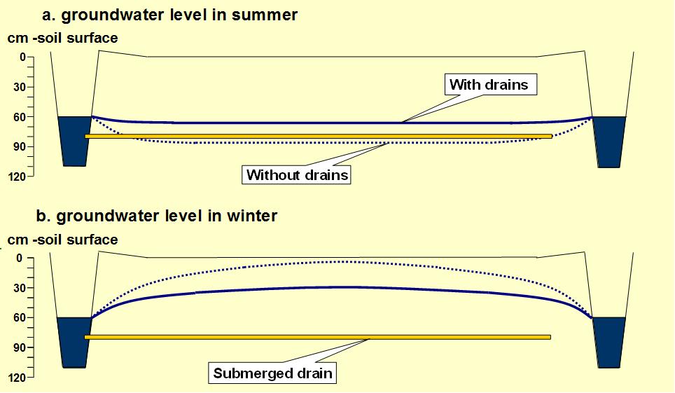
The picture shows a cross section through an agricultural field, bounded by two ditches. A submerged drain (yellow bar in the picture) is installed at 80 cm below the soil surface. It ends in the ditch on the left side at 20 cm below the water level in the ditch. The dotted line indicates the position of the groundwater table in the situation without the submerged drain; the continuous blue line indicates the position in the situation where the submerged drain is installed. The lines show that in summer the groundwater level is raised to nearly the level of the ditch water by the submerged drain, whereas the level would be approximately 30 cm lower without the drain.
In winter, in the situation with the submerged drain, the groundwater level is around 40 cm below the soil surface. This enables the farmer to use the field for grazing or to traffic the field. However, in the situation without the drain, the groundwater level nearly reaches the soil surface in the centre of the field, impeding traffic or grazing on the field.
Technical knowledge required for field staff / advisors: moderate (Estimates of economic benefits due to increased grass production and grazing periods vary between years with meteorological conditions.)
Technical knowledge required for land users: moderate (Specific conditions apply to the dimensions and positioning of submerged drains in the fields. Level position and lebgth are critical.)
Technical knowledge required for companies installing the drains: moderate (Specific conditions apply to the dimensions and positioning of submerged drains in the fields. Level position and lebgth are critical. Soil must have sufficient bearing capacity during installation.)
Technical knowledge required for water board: moderate (submerged drains increase the water supply and discharge from groundwater level management units. Additional pumping effort can be prevented by informed water level management.)
Technical knowledge required for researchers: (the implications of submerged drains on the water management in an entire management unit should be explored using coupled hydraulic and rainfall-runoff models.)
Main technical functions: improvement of topsoil structure (compaction), maintaining soil organic matter
Secondary technical functions: increase of infiltration, increase / maintain water stored in soil, drainage of excess rainfall
Other type of management: Maintaining high groundwater levels.
4.3 Материал болон зардалд хамаарах ерөнхий мэдээлэл
бусад/үндэсний мөнгөн нэгж (тодорхойл):
euro
Ам.доллар ба үндэсний мөнгөн нэгж хоорондын хөрвөх үнийг тодорхойл (шаардлагатай бол): 1 USD =:
1.09
4.4 Бий болгох үйл ажиллагаа
| Үйл ажиллагаа | Арга хэмжээний төрөл | Хугацаа | |
|---|---|---|---|
| 1. | maintenance of drains and outlet in ditch | Барилга байгууламжийн | |
| 2. | installation of submerged drains | Менежментийн | in dry periods |
4.5 Бий болгоход шаардагдсан зардал, хөрөнгийн өртөг
| Зардлын нэр, төрөл | Хэмжих нэгж | Тоо хэмжээ | Нэгжийн үнэ | Зардал бүрийн нийт өртөг | Нийт дүнгээс газар ашиглагчийн төлсөн % | |
|---|---|---|---|---|---|---|
| Хөдөлмөр эрхлэлт | maintenance of drains and outlet in ditch | ha | 1.0 | 30.14 | 30.14 | 100.0 |
| Хөдөлмөр эрхлэлт | installation of submerged drains | ha | 1.0 | 1980.0 | 1980.0 | 100.0 |
| Технологи бий болгох нийт үнэ өртөг | 2010.14 | |||||
Тайлбар:
Lifespan of the drains: 30 years
4.6 Арчилгаа/ урсгал үйл ажиллагаа
| Үйл ажиллагаа | Арга хэмжээний төрөл | Хугацаа/ давтамж | |
|---|---|---|---|
| 1. | maintenance of submerged drains | Менежментийн | several times in lifetime of drains (30 y) |
4.7 Арчилгаа/урсгал ажилд шаардагдсан зардал, хөрөнгийн өртөг (нэг жилд)
| Зардлын нэр, төрөл | Хэмжих нэгж | Тоо хэмжээ | Нэгжийн үнэ | Зардал бүрийн нийт өртөг | Нийт дүнгээс газар ашиглагчийн төлсөн % | |
|---|---|---|---|---|---|---|
| Бусад | Annual cost incl maintenance | ha | 1.0 | 127.0 | 127.0 | 100.0 |
| Технологийн арчилгаа/урсгал үйл ажиллагаанд шаардагдах нийт үнэ өртөг | 127.0 | |||||
Тайлбар:
Machinery/ tools: establishment and installation require specific skills and machinery; hired, not done by the farmer himself
Investment costs of 1500-1800 €/ha are based on submerged drains at 6 m distance. Costs per m of drain establishment based on drains of 6 cm diameter. Costs based on practical experience from farmers. Drains may have a lifetime of 30 years and require little maintenance.
Specific skills and machinery are required for installation and maintenance, hired from a drainage company. The farmer must only ensure that the outlets of the drains in the ditches remain open and undamaged.
4.8 Зардалд нөлөөлж байгаа хамгийн чухал хүчин зүйл
Өртөг, зардалд нөлөөлөх гол хүчин зүйл:
We do not have information on specific cost items, only on establishment costs ad between 1500 and 1800 euro/ha, and annual cost of 117 €/ha incl maintenance, assuming a 20-year life time. Establishment costs can also be expressed per m of drain, i.e. 1.10 EURO per m including materials (drain of 6 cm diameter).
Determinate factors include size and geometry of fields; installation in the length direction is cheaper, and results in fewer outlets in the receiving ditch.
5. Байгаль ба нийгмийн нөхцөл
5.1 Уур амьсгал
Жилийн нийлбэр хур тундас
- < 250 мм
- 251-500 мм
- 501-750 мм
- 751-1,000 мм
- 1,001-1,500 мм
- 1,501-2,000 мм
- 2,001-3,000 мм
- 3,001-4,000 мм
- > 4,000 мм
Хур тунадасны талаархи тодорхойлолт/ тайлбар:
Distribution of rainfall over the year: 23% (winter), 19% (spring), 27% (summer) and 31% (autumn)
Агро-уур амьсгалын бүс
- чийглэг
- чийглэг
Thermal climate class: temperate
5.2 Гадаргын хэлбэр
Дундаж налуу:
- хавтгай (0-2 %)
- бага зэрэг налуу (3-5 %)
- дунд зэрэг налуу (6-10 % )
- хэвгий (11-15 %)
- налуу (16-30 %)
- их налуу (31-60 % )
- эгц налуу (>60 %)
Гадаргын хэлбэр:
- тэгш өндөрлөг / тал
- нуруу
- уулын энгэр
- дов толгод
- бэл
- хөндий
Өндрийн бүслүүр:
- 0-100 д.т.д. м.
- 101-500 д.т.д. м.
- 501-1,000 д.т.д м.
- 1,001-1,500 д.т.д м.
- 1,501-2,000 д.т.д м.
- 2,001-2,500 д.т.д. м.
- 2,501-3,000 д.т.д. м.
- 3,001-4,000 д.т.д м.
- > 4,000 д.т.д. м.
Гадаргын талаархи тодорхойлолт ба бусад тайлбар:
Altitudinal zone: 0-100 m a.s.l. (Submerged drains are designed for polders in lowland areas on peat soils)
Landforms: Plateau/plains (submerged drains are designed to drain level fields)
Slopes on average: Flat (submerged drains are designed to drain flat terrain, based on hydraulic prressure head differences between field and ditch)
5.3 Хөрс
Хөрсний дундаж зузаан:
- маш нимгэн (0-20 см)
- нимгэн (21-50 см)
- дунд зэрэг зузаан (51-80 см)
- зузаан (81-120 cм)
- маш зузаан (>120 cм)
Хөрсний бүтэц (өнгөн хөрс):
- нарийн /хүнд (шаварлаг)
Өнгөн хөрсөнд агуулагдах ялзмаг:
- их (>3 %)
Боломжтой бол хөрсний бүрэн тодорхойлолт, боломжит мэдээллийг өгнө үү, жишээ нь хөрсний төрөл, хөрсний урвалын орчин/хүчиллэг байдал, катион солилцох чадавхи, азотын хэмжээ, давсжилт г.м.
Soil depth on average: Very deep (if the peat substrate is considered as part of the soil profile, soils are deeper than 120 cm, with peat packages up to 13 m in some parts of the western Dutch peatland area) and shallow (If the top of the C-horizon is considered as the bottom of the soil profile. C-horizons typically start at 15-30 cm below the soil surface)
Soil texture is fine/heavy (for peat soils with a clayey top layer. In peat soils without such a top layer, a soil texture indication is not applicable. Peat soils are defined as having at least 40 cm of peat in the top 80 cm)
Soil fertility is very high (peat soils are able to supply ample nutrients to plants provided that they are well drained)
Topsoil organic matter is high (Organic matter contents in the topsoil are above 20%. Peat soils are defined as having at least 40 cm of peat in the top 80 cm according to the Dutch soil classification system)
Soil drainage/infiltration is poor/none (peat soils inherently have poor drainage due to their low position with reference to the groundwater level in the regional water system. Values of Ksat reported 2.9-5.0 cm/d)
Soil water storage capacity is very high (the soil water storage capacity is very high due to the large pore space (0.70-0.90 m3/m3))
5.4 Усны хүртээмж ба чанар
Гүний усны түвшин:
< 5 м
Гадаргын усны хүртээмж:
сайн
Усны чанар (цэвэршүүлээгүй):
зөвхөн газар тариалангийн зориулалтаар ашиглах (усалгаа)
Усны чанар, нөөцийн талаархи тайлбар ба бусад тодорхойлолт:
Ground water table: <5m (Average lowest grondwater level in the pilot region is 5-10 cm below the soil surface; average highest level 55-65 cm)
Availability of surface water is good (surface water is amply available due to the low position of the peat soil area compared to the mean sea level, and due to the dense network of ditches and other surface water conveyors and bodies) and excess (surface water levels are under continuous control by the water boards. Therefore flood situations do not occur, but under high-intensity rainfall events fields may submerge)
Water quality (untreated) is for agriculutral use only (Irrigation, surface and groundwater can be used for agriculture without treatment. Nutrient rich water emerging by capillary rise in polders may not be suitable for nature.)
Biodiversity is medium (the grasslands in the western peatsoil area are suitable habtitats for meadow birds)
5.5 Биологийн олон янз байдал
Зүйлийн олон янз байдал:
- дунд зэрэг
5.6 Технологи нэвтрүүлсэн газар ашиглагчдын тухай мэдээлэл
Үйлдвэрлэлийн системийн зах зээлийн чиг баримжаа:
- худалдаа наймааны/ зах зээлийн
Бусад эх үүсвэрээс олох орлого:
- Нийт орлогын 10 %-иас доош
Чинээлэг байдлын түвшин:
- дундаж
Хувь хүн эсвэл бүлэг:
- Хувь хүн / өрх
Газар ашиглагчдын бусад шинж чанарыг тодорхойл:
Difference in the involvement of women and men: Executives of agricultural enterprises in The Netherlands are usually men.
Population density: 200-500 persons/km2
Annual population growth: 1% - 2%
100% of the land users are average wealthy and own 100% of the land.
Off-farm income specification: Dairy farmers in this part of The Netherlands spend 100% of their time on the farm. Sometimes their wives have jobs earning off-farm income.
Market orientation is commercial/market (intensive dairy farming in the NL produces for the market)
5.7 Технологи нэвтрүүлсэн газар ашиглагчийн өмчилж буй, эзэмшиж буй, түрээсэлж буй эсвэл ашиглаж буй (ашиглах эрх) газрын талбай
- < 0.5 га
- 0.5-1 га
- 1-2 га
- 2-5 га
- 5-15 га
- 15-50 га
- 50-100 га
- 100-500 га
- 500-1,000 га
- 1,000-10,000 га
- > 10,000 га
Тайлбар:
On average, Dutch dairy farms have 50 ha grazing land for 90 dairy cows (2013).
5.8 Газар эзэмшил, газар ашиглах эрх, ус ашиглах эрх
Газар өмчлөл:
- хувь хүн, өмчийн гэрчилгээтэй
Газар ашиглах эрх:
- хувь хүн
Ус ашиглах эрх:
- түрээсийн хэлбэрээр
5.9 Дэд бүтэц, үйлчилгээний хүртээмж
эрүүл мэнд:
- ядуу
- дунд зэргийн
- сайн
боловсрол:
- ядуу
- дунд зэргийн
- сайн
техник зөвлөгөө:
- ядуу
- дунд зэргийн
- сайн
хөдөлмөр эрхлэлт (жишээ нь, ХАА-аас өөр):
- ядуу
- дунд зэргийн
- сайн
зах зээл:
- ядуу
- дунд зэргийн
- сайн
эрчим хүчний хангамж:
- ядуу
- дунд зэргийн
- сайн
зам тээвэр:
- ядуу
- дунд зэргийн
- сайн
усан хангамж ба ариутгал:
- ядуу
- дунд зэргийн
- сайн
санхүүгийн үйлчилгээ:
- ядуу
- дунд зэргийн
- сайн
6. Үр нөлөө ба дүгнэлт
6.1 Технологийн талбайд үзүүлсэн нөлөө
Нийгэм-эдийн засгийн үр нөлөө
Үйлдвэрлэл
тэжээл үйлдвэрлэл
ГТМ хэрэгжихээс өмнөх тоо хэмжээ:
10.7-12.4 tons DM/ha11575
ГТМ хэрэгжиснээс хойшхи тоо хэмжээ:
9.8-12.4 ton DM/ha10975
Тайлбар/ тодорхой дурьдах:
Net grass yields (DM) measured on experimental plots. May slightly decrease due to SMD, but less loss due to trampling, increased length of grazing season. This delivers 500 kg DM/ha extra fodder produced and 30 extra grazing days.
But also loss possible: From 11575 kg DM/ha to 10975 kg DM/ha Decrease in grass yield is possible between 3 and 9%. This does not take into account losses due to tramping in situation without drains and longer grazing season under SMD.
тэжээлийн чанар
ГТМ хэрэгжихээс өмнөх тоо хэмжээ:
275-417 kg N/ha
ГТМ хэрэгжиснээс хойшхи тоо хэмжээ:
235-389 kg N/ha
Тайлбар/ тодорхой дурьдах:
Slight decrease in N and P content of grass, but quality of grass is expected to improve due to better drained soil and improved bearing capacity
бүтээмж буурах эрсдэл
Тайлбар/ тодорхой дурьдах:
SMD enable a longer grazing season, increased bearing capacity and reduced risk of flooding of fields
Орлого, зарлага
ХАА-н зардал
Тайлбар/ тодорхой дурьдах:
reduced additional feedstock; benefits of extra grass yields and grazing days amount to 171 euro/ha
тухайн аж ахуйн орлого
Тайлбар/ тодорхой дурьдах:
net benefits of installing SMD are approx. 54 euro per ha per year
ажлын хэмжээ
Тайлбар/ тодорхой дурьдах:
trafficability and workability of fielfds improved due to drier topsoil conditions and increased bearing capacity
Нийгэм-эдийн засгийн бусад үр нөлөө
inlet and drainage of water
Тайлбар/ тодорхой дурьдах:
SMD require an increased inlet and drainage of water in the ditches by the water board, increased pumping hours: 10-22% in dry years; 7-12% in wet years.
Inlet: extra 36-86 mm/y in dry years, 19-45 mm in wet years
Drainage: 17-59 mm in dry years; 33-60 in wet year
Нийгэм-соёлын үр нөлөө
олон нийтийн институц
Тайлбар/ тодорхой дурьдах:
Community of Practice on SMD in peat soils enabled knowledge transfer between land users, research insttitutes, farmer's association and authorities
үндэсний институц
Тайлбар/ тодорхой дурьдах:
The CoP has informed water boards and provinces in the part of The Netherlands with problems due to soil subsidence
Improved livelihoods and human well-being
Тайлбар/ тодорхой дурьдах:
The long-term experiments in The Netherlands, pilots and activities of the farmers organisation LO Nederland, the Veenweide Informatie Centrum and the Community of Practice Submerged Drainage on Peat soils have increased the understanding of participating farmers of submerged drainage, the water accounting of their land, soil and soil quality. Tjey acquired practical knowledge on the implementation of the technology. Participating farmers continue to exchange knowledge and intend to extend the area under SMD. As a result of the pilots and the activities of the Community of Practice, interest for submerged drainage was raised among other dairy farmers, policy makers and authorities.
Экологийн үр нөлөө
Усны эргэлт/ илүүдэл
усны чанар
Тайлбар/ тодорхой дурьдах:
slight decrease of export of N, P and SO4 to the surface water
усны урсац
Тайлбар/ тодорхой дурьдах:
SMD increased drainage by 20-65 mm per year in 2011 and 2012
Хөрс
хөрсний чийг
Тайлбар/ тодорхой дурьдах:
SMD increased infiltration by 8-93 mm per year in 2011 and 2012
хөрс нягтрах
Тайлбар/ тодорхой дурьдах:
decreased soil subsidence to 50% (reductions of 3-6 and 5-8 mm/year)
Биологийн олон янз байдал: ургамал, амьтан
амьтны төрөл, зүйл
Тайлбар/ тодорхой дурьдах:
no direct impact on breeding conditions for meadow birds
Уур амьсгал болон гамшгийн эрсдлийг бууруулах
нүүрстөрөгч ба хүлэмжийн хийн ялгаруулалт
Тайлбар/ тодорхой дурьдах:
decreased GHG emissions in CO2 eq: 6.8-13.5 t/ha per year (pilot Keulevaart) and 11.3-18.1 (pilot Demmeriksekade)
Экологийн бусад үр нөлөө
Hazard towards adverse events
Тайлбар/ тодорхой дурьдах:
quicker lowering of groundwater table after extreme rainfall events (1-5 days)
Water management
Тайлбар/ тодорхой дурьдах:
More easy water management in polders: Fewer sub-polders with fixed ditch water level; possibility to create areas with high and low surface levels
6.2 Технологийн талбайн гадна үзүүлсэн үр нөлөө
нийтийн/хувийн хэвшлийн дэд бүтцэд учрах хохирол
Тайлбар/ тодорхой дурьдах:
reduced costs of infrastructure protection (30% or 3.5 M€/year until 2100 in the Frisian peat meadow area)
Cost of regional water management
Тайлбар/ тодорхой дурьдах:
due to smaller differences in water levels between water management units
6.3 Технологийн уур амьсгалын өөрчлөлт, цаг агаарын гамшигт үзэгдэлд өртөх байдал ба эмзэг байдал (газар ашиглагчийн бодлоор)
Уур амьсгалын аажим өөрчлөлт
Уур амьсгалын аажим өөрчлөлт
| Улирал | Уур амьсгалын өөрчлөлт/экстрим үзэгдлийн төрөл | Технологи түүний нөлөөг хэрхэн бууруулж байна? | |
|---|---|---|---|
| жилийн дундаж температур | Өсөлт | сайн |
Уур амьсгалаас хамаарах аюул (гамшиг)
Цаг уурын гамшигт үзэгдэл
| Технологи түүний нөлөөг хэрхэн бууруулж байна? | |
|---|---|
| орон нутгийн аадар бороо | сайн |
| орон нутгийн салхин шуурга | сайн |
Уур амьсгалын гамшиг
| Технологи түүний нөлөөг хэрхэн бууруулж байна? | |
|---|---|
| ган гачиг | мэдэхгүй |
Усзүйн гамшиг
| Технологи түүний нөлөөг хэрхэн бууруулж байна? | |
|---|---|
| усны үер (гол) | сайн |
Уур амьсгалд хамаарах бусад үр дагавар
Уур амьсгалд хамаарах бусад үр дагавар
| Технологи түүний нөлөөг хэрхэн бууруулж байна? | |
|---|---|
| цргалтын хугацаа багасах | сайн |
Тайлбар:
Under extreme rainfall events, submerged drains cannot prevent that the groundwater level rises to above the soil surface. However, the groundwater level will fall more quickly with submerged drainas than without, on average to 10 cm lower levels.
Effects of dry summers have not yet been measured in experiments.
6.4 Өртөг ба ашгийн шинжилгээ
Бий болгох зардалтай харьцуулахад ямар ашиг өгсөн бэ (газар ашиглагчийн бодлоор)?
Богино хугацаанд эргэн төлөгдөх байдал:
бага зэрэг эерэг
Урт хугацаанд эргэн төлөгдөх байдал:
эерэг
Арчилгаа/урсгал зардалтай харьцуулахад ямар ашиг өгсөн бэ (газар ашиглагчийн бодлоор)?
Богино хугацаанд эргэн төлөгдөх байдал:
бага зэрэг эерэг
Урт хугацаанд эргэн төлөгдөх байдал:
эерэг
Тайлбар:
A longer grazing season and the extra yield of fodder are the basis for a viable implementation of submerged drainage for land users. The CBA considers establishment and maintenance costs together: establishment costs of € 1800,-/ha, discounted over 20 years, including maintenance, result in annual cost of € 117,-/ha (6.5% of the investment). Benefits include 500 kg DM/ha extra grass use and 30 extra grazing days. This would yield € 171/ha, resulting in a net saldo of € 54,-. In addition SMD are an investment in sustainable soil management, resulting in an increased economic value of the land in the long term.
6.5 Технологи нэвтрүүлэлт
Боломжтой бол, тоогоор илэрхийл (өрхийн тоо эсвэл бүрхэх талбай):
13
Технологи нэвтрүүлсэн хүмүүсээс хэд нь өөрийн хүчээр технологийг хэрэгжүүлсэн бэ, өөрөөр хэлбэл гадны тусламж дэмжлэг авалгүйгээр?
- 90-100 %
Тайлбар:
13 land user families have adopted the Technology without any external material support
Comments on spontaneous adoption: The area under submerged drainage implemented by the 10 dairy farmers from the Community of Practice is 20 ha. The area under SMD in the three pilots described in this questionnaire is roughly an additional 0.05 km2 per farm.
There is a moderate trend towards spontaneous adoption of the Technology
Comments on adoption trend: Due to the growing interest in the peat soil area because of the relevance for climate mitigation and the economic risks of soil subsidence there is growing interest in SMD in combination iwth dynamic groundwater level management to reduce the rate of soil subsidence. Subsidy arrangements are in preparation, which will stimulate adoption of the technology by more dairy farmers.
6.7 Технологийн давуу тал/боломжууд
| Газар ашиглагчдын тодорхойлсон давуу тал/боломжууд |
|---|
| Submerged drains increase the number of days with a good bearing capacity of grassland, and therefore enable a longer grazing season and less trampling of grass. |
| Higher effective yield in total. |
| Short term: slightly cost effective. Long term: good cost effective. |
| Эмхэтгэгч, бусад мэдээлэл өгсөн хүмүүсийн өнцгөөс тодорхойлсон давуу тал/боломжууд |
|---|
|
Submerged drains allow a strong reduction of soil subsidence and GHG emissions (at least 50%, even >50% if combined with higher ditch water levels). How can they be sustained / enhanced? Further implementation by dairy farmers in the peat-meadow area. For this purpose the Community of Practice is recommended, as well as the arrangement of subsidies and the active involvement of regional government and water board. This applies to all mentioned advantages. |
| The quality of surface water in ditches will slightly improve. |
| Less problems with difference between subsiding soil surfaces and constant water levels in lakes and high water ditches (along houses). |
| Less sub-polders with a certain fixed ditch water level, and possibility to create areas with a high surface level (with submerged drains) and a low surface level (without SD). |
6.8 Технологийн дутагдалтай/сул тал/аюул болон тэдгээрийг хэрхэн даван туулах арга зам
| Газар ашиглагч нарын тодорхойлсон сул тал/ дутагдал/ эрсдэл | Тэдгээрийг хэрхэн даван туулах вэ? |
|---|---|
| Grass yield is lower due to reduced mineralization of nitrogen. | Yield could be increased due to better usage of manure (better NUE). On the other hand yield is increased due to increased number of days with a good bearing capacity of grassland, and a longer grazing season and less trampling of grass. |
| Эмхэтгэгч, бусад мэдээлэл өгсөн хүмүүсийн өнцгөөс тодорхойлсон сул тал/ дутагдал/ эрсдэл | Тэдгээрийг хэрхэн даван туулах вэ? |
|---|---|
| Submerged drains require more inlet water to polders. | Reduction of inlet requirement is possible by smart water management. This implies water level margins of +/- 10 cm and the use of weather forecasting. |
| Submerged drains require a bit more pumping to drain water under extreme rain events. |
7. Ном зүй ба холбоосууд
7.2 Ном, хэвлэлийн ишлэл
Гарчиг, зохиогч, он, ISBN:
Several reports on submerged drainage are available from Alterra, Wageningen UR (in Dutch). The report used for this WOCAT QT is:Effecten van onderwaterdrains in peilvak 9 van polder Groot-Wilnis Vinkeveen : modelstudie naar de effecten van onderwaterdrains op maaivelddaling, waterbeheer, wateroverlast en waterkwaliteit in peilvak 9 Author(s)Hendriks, R.F.A.; Akker, J.J.H. van den; Jansen, P.C.; Massop, H.Th.L. SourceWageningen : Alterra Wageningen UR, 2014 (Alterra-rapport 2480) - p. 124Other literature (in Dutch): Waarheen met het veen. Woestenberg, M. 2009. Uitegeverij Landwerk and Alterra, Wageningen URhttp://www.levenmetwater.nl/static/media/files/Boek_wmhv_def.pdf
Хаанаас авч болох вэ? Зардал?
Alterra Reports are available atlibrary.wur.nl
Холбоос ба модулууд
Бүгдийг дэлгэх Бүгдийг хаахХолбоосууд
Холбоос байхгүй байна
Модулууд
Модуль байхгүй байна