Rehabilitation of Degraded Lands ( Area closure) [Etiópia]
- Criação:
- Atualização:
- Compilador/a: Unknown User
- Editor: –
- Revisor: Fabian Ottiger
Kutura
technologies_1072 - Etiópia
Veja as seções
Expandir tudo Recolher tudo1. Informação geral
1.2 Detalhes do contato das pessoas capacitadas e instituições envolvidas na avaliação e documentação da tecnologia
1.3 Condições em relação ao uso da informação documentada através de WOCAT
Quando os dados foram compilados (no campo)?
30/05/2011
O compilador e a(s) pessoa(s) capacitada(s) aceitam as condições relativas ao uso de dados documentados através do WOCAT:
Sim
1.5 Referência ao(s) questionário(s) sobre as abordagens da GST
Community Organizations and Mobilization for Soil and Water … [Etiópia]
Community mobilization for soil and water conservation work in a watershed planning unit is an approach for collective action by organizing all active labor forces living in the kebele/peasant association into development group of 20-30 members and further divide into 1:5 work force to implement construction of soil and water …
- Compilador/a: Gizaw Desta Gessesse
2. Descrição da tecnologia de GST
2.1 Descrição curta da tecnologia
Definição da tecnologia:
Closing the degraded land to let it to regenerate by excluding human and animal interference ans speed up the regeneration process by applying some SWC activities and undertake enrichment plantation.
2.2 Descrição detalhada da tecnologia
Descrição:
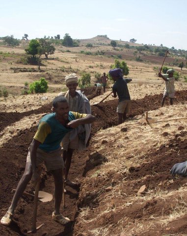
Area closure is suitable for degraded lands. Degraded areas are excluded from animal and human contact and integrated with activities that speed up regeneration process such as SWC activities, agronomic measures, vegetative and management measures.
Purpose of the Technology: Area closure improves the productivity of degraded lands and protects down stream fields and properties from flooding and improves ground water recharge.
Establishment / maintenance activities and inputs: Management and utilization plan prepared and agreed. Planning and design of supplimentary measures are integrated.
Natural / human environment: Area closure is applicable in all areas that have lost vegetation cover and has low soil fertility.
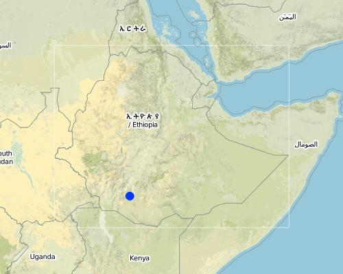
2.5 País/região/locais onde a tecnologia foi aplicada e que estão cobertos nesta avaliação
País:
Etiópia
Região/Estado/Província:
SNNPR
Especificação adicional de localização:
Lemo
Map
×2.6 Data da implementação
Caso o ano exato seja desconhecido, indique a data aproximada:
- mais de 50 anos atrás (tradicional)
2.7 Introdução da tecnologia
Especifique como a tecnologia foi introduzida:
- através de projetos/intervenções externas
Comentários (tipos de projeto, etc.):
It is introduced technology.
3. Classificação da tecnologia de GST
3.1 Principal/principais finalidade(s) da tecnologia
- Reduz, previne, recupera a degradação do solo
- Preserva ecossistema
3.2 Tipo(s) atualizado(s) de uso da terra onde a tecnologia foi aplicada

Terra de cultivo
- Cultura anual
- Cultura perene (não lenhosa)
- Cultura de árvores e arbustos
Principais plantações (colheitas para venda e consumo próprio):
Major cash crop annual cropping: Wheat
Major food crop annual cropping: Teff, barley, beans
Major food crop perennial (non-woody) cropping: Enset
Major cash crop tree/shrub cropping: Coffee, Chat

Misto (plantação, pastagem, árvores) inclusive agrofloresta
- Agrossilvipecuária
Principais produtos/serviços:
Forest products and services: timber, fuelwood, grazing / browsing, nature conservation / protection
Comentários:
Major land use problems (compiler’s opinion): Overgrazing, low awarness of land users, lack of management plan for communal lands and low level of diversification of land users activities.
Major land use problems (land users’ perception): Shortage of grazing lands, lack of common understanding of the management of common resources.
Semi-nomadism / pastoralism: Yes
Grazingland comments: Inspite of decreasing grazing lands, farmers still want to own some heads of livestock. Grazinglands as a result are highly pressurized. Land users cut grass from area closures and carry them home to feed their livestock. Some land users who have few polts for grazing close them to grow grass.
Plantation forestry: Yes
Problems / comments regarding forest use: Natural forests do not exist. Planted forests are managed by the community. In the SWC area, a larger area was planted some 20 years ago but at present the planted forests have been cleared for cultivation. This is the result of high population growth. Some of the planteed forests have been cleared by demobilizing soldiers.
Type of cropping system and major crops comments: Cereals - Legumes - Cereals
Constraints of infrastructure network (roads, railways, pipe lines, power lines)
3.3 Mais informações sobre o uso da terra
Abastecimento de água para a terra na qual a tecnologia é aplicada:
- Precipitação natural
Número de estações de cultivo por ano:
- 2
Especifique:
Longest growing period in days: 180 Longest growing period from month to month: Apr - Nov Second longest growing period in days: 150 Second longest growing period from month to month: Jan - May
3.4 Grupo de GST ao qual pertence a tecnologia
- Reserva ( suspensão do uso, apoio à recuperação)
3.5 Difusão da tecnologia
Comentários:
Total area covered by the SLM Technology is 10.5 km2.
Communities develop positive attitude towards activities implemented and results obtained such as livestock feed, fuel wood, bee forage, farm implements and construction materials.
3.6 Medidas de GST contendo a tecnologia
3.7 Principais tipos de degradação da terra abordados pela tecnologia

Erosão do solo pela água
- Wt: Perda do solo superficial/erosão de superfície
- Wg: Erosão por ravinas/ravinamento
- Wo: efeitos de degradação externa

Deteriorização química do solo
- Cn: declínio de fertilidade e teor reduzido de matéria orgânica (não causado pela erosão)

Deteriorização física do solo
- Pu: perda da função bioprodutiva devido a outras atividades

Degradação da água
- Ha: aridificação
Comentários:
Main type of degradation addressed: Wt: loss of topsoil / surface erosion, Wg: gully erosion / gullying
Secondary types of degradation addressed: Wo: offsite degradation effects, Cn: fertility decline and reduced organic matter content, Pu: loss of bio-productive function due to other activities, Ha: aridification
3.8 Redução, prevenção ou recuperação da degradação do solo
Especifique o objetivo da tecnologia em relação a degradação da terra:
- Recuperar/reabilitar solo severamente degradado
Comentários:
Secondary goals: prevention of land degradation, mitigation / reduction of land degradation
4. Especificações técnicas, implementação de atividades, entradas e custos
4.2 Especificações técnicas/ explicações do desenho técnico
SNNPR
Technical knowledge required for field staff / advisors: high
Technical knowledge required for land users: low
Main technical functions: control of dispersed runoff: retain / trap, control of concentrated runoff: retain / trap, improvement of ground cover, increase of infiltration
Secondary technical functions: increase / maintain water stored in soil, water harvesting / increase water supply, increase in soil fertility
Early planting
Material/ species: maize and potato
Remarks: row planting, broad casting
Mixed cropping / intercropping
Material/ species: maize & haricot bean
Remarks: row planting
Legume inter-planting
Remarks: broad casting
Manure / compost / residues
Material/ species: animal dung
Remarks: broad casting
Contour tillage
Remarks: along the contour
In blocks
Vegetative material: T : trees / shrubs
Number of plants per (ha): 2500
Vertical interval within rows / strips / blocks (m): 2
Vegetative measure: in blocks
Vegetative material: G : grass
Number of plants per (ha): 3333
Vertical interval between rows / strips / blocks (m): 1
Spacing between rows / strips / blocks (m): 10
Vertical interval within rows / strips / blocks (m): 0.3
Width within rows / strips / blocks (m): 0.3
Vegetative measure: Vegetative material: G : grass
Vegetative measure: Vegetative material: G : grass
Vegetative measure: Vegetative material: G : grass
Trees/ shrubs species: Acacia saligina, Acaccia decurrens, Omedila, Grevillea robusta
Grass species: Desho, phalaris
Slope (which determines the spacing indicated above): 15.00%
If the original slope has changed as a result of the Technology, the slope today is (see figure below): 8.00%
Gradient along the rows / strips: 0.00%
Retention/infiltration ditch/pit, sediment/sand trap
Vertical interval between structures (m): 3
Spacing between structures (m): 10
Depth of ditches/pits/dams (m): 0.5
Width of ditches/pits/dams (m): 0.3
Length of ditches/pits/dams (m): 3
Height of bunds/banks/others (m): 0.3
Width of bunds/banks/others (m): 1
Length of bunds/banks/others (m): 3
Terrace: forward sloping
Vertical interval between structures (m): 2
Spacing between structures (m): 10
Depth of ditches/pits/dams (m): 0.3
Width of ditches/pits/dams (m): 0.5
Length of ditches/pits/dams (m): 5
Height of bunds/banks/others (m): 0.3
Width of bunds/banks/others (m): 1
Length of bunds/banks/others (m): 30
Construction material (earth): Soil excavated from the ditches is used to make the embankment
Construction material (stone): Hill side terraces are supported with stones at the downslope side to make them stronger and stable.
Slope (which determines the spacing indicated above): 15%
If the original slope has changed as a result of the Technology, the slope today is: 8%
Lateral gradient along the structure: 0%
Vegetation is used for stabilisation of structures.
Change of land use type: from degraded agricultural land to area closure and practicing of cut and carry.
Other type of management: change of management / intensity level - from open access forms of grazing to guarding, plantation and construction of various SWC techniques.
4.3 Informação geral em relação ao cálculo de entradas e custos
Outro/moeda nacional (especifique):
Birr
Indique a taxa cambial do dólar norte americano para a moeda local (se relevante): 1 USD =:
8,6
Indique a média salarial da mão-de-obra contratada por dia:
0.70
4.4 Atividades de implantação
| Atividade | Tipo de medida | Periodicidade | |
|---|---|---|---|
| 1. | Seedling production | Vegetativo | through out the year |
| 2. | Transportation | Vegetativo | beginning of rains |
| 3. | Planting | Vegetativo | beginning of rains |
| 4. | Surveying | Estrutural | dry season |
| 5. | Digging of ditches and construction of structural measures | Estrutural | dry season |
| 6. | Stablization of terraces | Estrutural | |
| 7. | Surveying the degraded land | Gestão | dry season |
| 8. | Awarness creation | Gestão | slack period from farming |
| 9. | Planning | Gestão | any time |
| 10. | Closing the area | Gestão |
4.5 Custos e entradas necessárias para a implantação
| Especifique a entrada | Unidade | Quantidade | Custos por unidade | Custos totais por entrada | % dos custos arcados pelos usuários da terra | |
|---|---|---|---|---|---|---|
| Mão-de-obra | Labour | ha | 1,0 | 505,8 | 505,8 | 50,0 |
| Equipamento | Machine use | ha | 1,0 | 83,27 | 83,27 | |
| Equipamento | Tools | ha | 1,0 | 19,26 | 19,26 | 70,0 |
| Material vegetal | Seeds | ha | 1,0 | 69,76 | 69,76 | 100,0 |
| Material vegetal | Seedlings | ha | 1,0 | 116,28 | 116,28 | 100,0 |
| Custos totais para a implantação da tecnologia | 794,37 | |||||
Comentários:
Duration of establishment phase: 24 month(s)
4.6 Atividades recorrentes/manutenção
| Atividade | Tipo de medida | Periodicidade/frequência | |
|---|---|---|---|
| 1. | land preparation | Agronômico | before rains / each cropping season |
| 2. | Replanting | Vegetativo | rainy season /once |
| 3. | Stablization of terraces | Estrutural | rainy season/annual |
| 4. | Appointing guards | Gestão | / annual |
4.7 Custos e entradas necessárias pata a manutenção/atividades recorrentes (por ano)
| Especifique a entrada | Unidade | Quantidade | Custos por unidade | Custos totais por entrada | % dos custos arcados pelos usuários da terra | |
|---|---|---|---|---|---|---|
| Equipamento | Machine use | ha | 1,0 | 81,39 | 81,39 | |
| Material vegetal | Seedlings | ha | 1,0 | 7,3 | 7,3 | 100,0 |
| Custos totais para a manutenção da tecnologia | 88,69 | |||||
Comentários:
Machinery/ tools: hoe, shovel, gaso
The cost is calculated for labour needed to the construct SWC activities to rehablitate one hectar of degraded land.
4.8 Fatores mais importantes que afetam os custos
Descreva os fatores mais determinantes que afetam os custos:
Higher slopes and shallow soil depths increase the cost of construction.
5. Ambiente natural e humano
5.1 Clima
Precipitação pluviométrica anual
- <250 mm
- 251-500 mm
- 501-750 mm
- 751-1.000 mm
- 1.001-1.500 mm
- 1.501-2.000 mm
- 2.001-3.000 mm
- 3.001-4.000 mm
- > 4.000 mm
Especificações/comentários sobre a pluviosidade:
900-1400 mm
Zona agroclimática
- Subúmido
> 180 days of LGP
5.2 Topografia
Declividade média:
- Plano (0-2%)
- Suave ondulado (3-5%)
- Ondulado (6-10%)
- Moderadamente ondulado (11-15%)
- Forte ondulado (16-30%)
- Montanhoso (31-60%)
- Escarpado (>60%)
Formas de relevo:
- Planalto/planície
- Cumes
- Encosta de serra
- Encosta de morro
- Sopés
- Fundos de vale
Zona de altitude:
- 0-100 m s.n.m.
- 101-500 m s.n.m.
- 501-1.000 m s.n.m.
- 1.001-1.500 m s.n.m.
- 1.501-2.000 m s.n.m.
- 2.001-2.500 m s.n.m.
- 2.501-3.000 m s.n.m.
- 3.001-4.000 m s.n.m.
- > 4.000 m s.n.m.
Comentários e outras especificações sobre a topografia:
Altitudinal zone: 2001-2500 m a.s.l. ( <2400m a.s.l., ranked 1) and 1,501-2,000 m a.s.l. ( >1900m a.s.l., ranked 2)
Slopes on average: Rolling (ranked 1), hilly (ranked 2) and gentle, moderate and steep (all ranked 3)
5.3 Solos
Profundidade do solo em média:
- Muito raso (0-20 cm)
- Raso (21-50 cm)
- Moderadamente profundo (51-80 cm)
- Profundo (81-120 cm)
- Muito profundo (>120 cm)
Textura do solo (solo superficial):
- Médio (limoso, siltoso)
- Fino/pesado (argila)
Matéria orgânica do solo superficial:
- Médio (1-3%)
- Baixo (<1%)
Caso disponível anexe a descrição completa do solo ou especifique as informações disponíveis, p. ex. tipo de solo, PH/acidez do solo, nitrogênio, capacidade de troca catiônica, salinidade, etc.
Soil depth on average: Also moderately deep (ranked 2) and shallow (ranked 3)
Soil texture: Fine/heavy (mainly clay loam, ranked 1) and medium (ranked 2)
Soil fertility is medium (ranked 1), low (ranked 2), high (ranked 3)
Soil drainage/infiltration is good (ranked 1) and medium (ranked 2)
Soil water storage capacity high (ranked 1) and medium (ranked 2)
5.6 Características dos usuários da terra que utilizam a tecnologia
Orientação de mercado do sistema de produção:
- Subsistência (autoabastecimento)
- Misto (subsistência/comercial)
Rendimento não agrícola:
- Menos de 10% de toda renda
Nível relativo de riqueza:
- Pobre
- Média
Nível de mecanização:
- Trabalho manual
- Tração animal
Indique outras características relevantes dos usuários da terra:
Population density: 200-500 persons/km2
Annual population growth: 3% - 4%
6% of the land users are rich and own 15% of the land.
45% of the land users are average wealthy and own 40% of the land.
35% of the land users are poor and own 30% of the land.
12% of the land users are poor and own 20% of the land.
Off-farm income specification: Some land users are engaged in small trading and some are daily labourer when they are free from field activities.
Level of mechanization: Animal traction (oxen plough system, ranked 1) and manual work (hoe and gaso, ranked 2)
Market orientation of forest production system: Mixed (ranked 1, individual plantation for market and domestic consumption), subsistence (ranked 2, individual woodlots plantation for domestic consumption) and commercial/market (ranked 3, community plantation for sale)
5.7 Média da área de terra própria ou arrendada por usuários da terra que utilizam a tecnologia
- < 0,5 ha
- 0,5-1 ha
- 1-2 ha
- 2-5 ha
- 5-15 ha
- 15-50 ha
- 50-100 ha
- 100-500 ha
- 500-1.000 ha
- 1.000-10.000 ha
- > 10.000 ha
Comentários:
Crop land: Average holding size is about 0.5 ha
Grazing land: Owing to expansion of cultivated land, grazing land size has reduced and estimated at about 0.1 ha per household.
Forest land: Due to cultivated land expansion the average holding size is about 0.15ha
5.8 Propriedade de terra, direitos de uso da terra e de uso da água
Propriedade da terra:
- Estado
Direitos do uso da terra:
- Indivíduo
6. Impactos e declarações finais
6.1 Impactos no local mostrados pela tecnologia
Impactos socioeconômicos
Produção
Produção agrícola
Comentários/especificar:
soil depth increased and soil fertility improved.
Produção de forragens
Comentários/especificar:
biomass increased
Qualidade da forragem
Comentários/especificar:
biomass increased
Produção de madeira
Comentários/especificar:
construction and fuel wood available
Renda e custos
Rendimento agrícola
Comentários/especificar:
land productivity per unit area improved.
Impactos socioculturais
Instituições comunitárias
Instituições nacionais
Conhecimento de GST/ degradação da terra
Atenuação de conflitos
Comentários/especificar:
loss of land for grazing and cultivation
Impactos ecológicos
Ciclo hídrico/escoamento
Drenagem de excesso de água
Solo
Umidade do solo
Comentários/especificar:
productivity is enhanced
Cobertura do solo
Comentários/especificar:
vegetation cover is improved
Biodiversidade: vegetação, animais
Controle de praga/doença
Comentários/especificar:
Introduction of pests/wild animals
Outros impactos ecológicos
Soil fertility
Biodiversity
6.2 Impactos externos mostrados pela tecnologia
Caudal confiável e estável em período seco
Comentários/especificar:
ground water recharging is improved
Cheias de jusante
Comentários/especificar:
runoff from the watershed is highly reduced
Sedimentação a jusante
Comentários/especificar:
sediments deposited behind the bund
6.4 Análise do custo-benefício
Como os benefícios se comparam aos custos de implantação (do ponto de vista dos usuários da terra)?
Retornos a curto prazo:
negativo
Retornos a longo prazo:
positivo
Como os benefícios se comparam aos custos recorrentes/de manutenção(do ponto de vista dos usuários da terra)?
Retornos a curto prazo:
levemente positivo
Retornos a longo prazo:
positivo
6.5 Adoção da tecnologia
Se disponível, determine a quantidade (número de unidades familiares e/ou área abordada):
3990
Entre todos aqueles que adotaram a tecnologia, quantos adotaram espontaneamente, ou seja, sem receber nenhum incentivo material/pagamentos?
- 0-10%
Comentários:
97% of land user families have adopted the Technology with external material support
3800 land user families have adopted the Technology with external material support
Comments on acceptance with external material support: estimates
5% of land user families have adopted the Technology without any external material support
190 land user families have adopted the Technology without any external material support
Comments on spontaneous adoption: estimates
There is a moderate trend towards spontaneous adoption of the Technology
Comments on adoption trend: The farmers have made some modifications in order to increase the effectivness of the technology, by making fences around enclosures.
6.7 Pontos fortes/vantagens/oportunidades da tecnologia
| Pontos fortes/vantagens/oportunidades na visão do usuário da terra |
|---|
|
Feed and forage sources improved How can they be sustained / enhanced? Cut and carry system |
|
Availability of fuel wood, farm implements and construction materials How can they be sustained / enhanced? integrate with multipurpose tree species |
| Income from beekeeping due to area closure |
| Pontos fortes/vantagens/oportunidades na visão do compilador ou de outra pessoa capacitada |
|---|
|
Income generated from wood and grass sales. How can they be sustained / enhanced? Equal share from the benefit to all land users. |
|
Rapid recovery and rehabilitation of degraded lands. How can they be sustained / enhanced? Integrate with multipurpose techniques and encourage cut and carry system. |
|
The environment is protected, wildlife attracted and unproductive areas become productive. How can they be sustained / enhanced? Awarness creation and technical support |
Links e módulos
Expandir tudo Recolher tudoLinks
Community Organizations and Mobilization for Soil and Water … [Etiópia]
Community mobilization for soil and water conservation work in a watershed planning unit is an approach for collective action by organizing all active labor forces living in the kebele/peasant association into development group of 20-30 members and further divide into 1:5 work force to implement construction of soil and water …
- Compilador/a: Gizaw Desta Gessesse
Módulos
Não há módulos