Soil Bund with Contour Cultivation [Etiópia]
- Criação:
- Atualização:
- Compilador/a: Unknown User
- Editor: –
- Revisor: Fabian Ottiger
Ditchira, Kab (Amharic)
technologies_1073 - Etiópia
Veja as seções
Expandir tudo Recolher tudo1. Informação geral
1.2 Detalhes do contato das pessoas capacitadas e instituições envolvidas na avaliação e documentação da tecnologia
Pessoa(s) capacitada(s)
Especialista em GST:
Tafese Berhanu
0465552211
Hadiya zone
Hossana
Etiópia
Especialista em GST:
Watchiso Adibacho
0465552211
Hadiya zone
Hossana
Etiópia
1.3 Condições em relação ao uso da informação documentada através de WOCAT
Quando os dados foram compilados (no campo)?
30/05/2011
O compilador e a(s) pessoa(s) capacitada(s) aceitam as condições relativas ao uso de dados documentados através do WOCAT:
Sim
2. Descrição da tecnologia de GST
2.1 Descrição curta da tecnologia
Definição da tecnologia:
It is a structural measure with an embankment of soil or stones or soil and stones, constructed along the contour and stablized with vegetative measures (grass and fodder trees).
2.2 Descrição detalhada da tecnologia
Descrição:
Applied on different land uses on slope of more than 3%. This practice is widely used by farmers in the area. Stone and stone faced bunds height depends on the availability of stones. On the average the width is 1-1.2m and hieght is 0.6-0.7m.
Purpose of the Technology: Bunds reduce the velocity of runoff and soil erosion, retains water behind the bund and let it infiltrate. It further helps in ground water recharging.
Establishment / maintenance activities and inputs: Planning is made by community/group and individual discussion and reach a consensus on layout, spacing, implementation modalities and management requirments is reached before implementation.
Natural / human environment: The technology is applicable in areas where soil is moderately deep and stones are available
2.3 Fotos da tecnologia
Galeria de Mídias
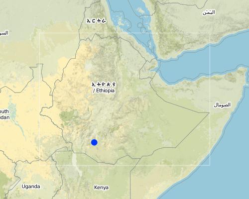
2.5 País/região/locais onde a tecnologia foi aplicada e que estão cobertos nesta avaliação
País:
Etiópia
Região/Estado/Província:
SNNPR/Hadiya/Lemo
Especificação adicional de localização:
Lemo
Map
×2.6 Data da implementação
Caso o ano exato seja desconhecido, indique a data aproximada:
- mais de 50 anos atrás (tradicional)
2.7 Introdução da tecnologia
Especifique como a tecnologia foi introduzida:
- através de projetos/intervenções externas
Comentários (tipos de projeto, etc.):
Other countries and also other woredas in the country.
3. Classificação da tecnologia de GST
3.2 Tipo(s) atualizado(s) de uso da terra onde a tecnologia foi aplicada

Terra de cultivo
- Cultura anual
- Cultura perene (não lenhosa)
- Cultura de árvores e arbustos
Principais plantações (colheitas para venda e consumo próprio):
Major cash crop annual cropping: Wheat
Major food crop annual cropping: Maize
Major cash crop perennial (non-woody) cropping: sugar cane
Major food crop perennial (non-woody) cropping: sugar cane
Major cash crop perennial tree/shrub cropping: coffee, Enset
Major food crop perennial tree/shrub cropping: sugar cane

Floresta/bosques
Produtos e serviços:
- Madeira
- Lenha
- Pastagem/Alimentação de folhas e brotos
Comentários:
Major land use problems (compiler’s opinion): Absence of land use policy, low level of awarness, shortage of farm lands.
Major land use problems (land users’ perception): Continous cultivation, poor soil fertility, poverty, shortage of cultivated lands.
Plantation forestry: Yes
Problems / comments regarding forest use: Many peasant kebeles have earned money by selling eucalyptus grown on plantation areas of the community. Some have built schools from the proceeds. Some kebeles have shared sizable money from the sales of trees.
Type of cropping system and major crops comments: Cereals - legumes - cereals
3.3 Mais informações sobre o uso da terra
Abastecimento de água para a terra na qual a tecnologia é aplicada:
- Precipitação natural
Número de estações de cultivo por ano:
- 2
Especifique:
Longest growing period in days: 180 Longest growing period from month to month: Apr - Nov Second longest growing period in days: 150
3.4 Grupo de GST ao qual pertence a tecnologia
- Medidas de curva de nível
3.5 Difusão da tecnologia
Comentários:
Total area covered by the SLM Technology is 173 m2.
Nowadays communities have developed positive attitudes towards SWC technologies implemented and the results obtained by practicing measures, which have reduced runoff and soil erosion reduced and land increased productivity.
3.6 Medidas de GST contendo a tecnologia
3.7 Principais tipos de degradação da terra abordados pela tecnologia

Erosão do solo pela água
- Wt: Perda do solo superficial/erosão de superfície
- Wg: Erosão por ravinas/ravinamento

Deteriorização química do solo
- Cn: declínio de fertilidade e teor reduzido de matéria orgânica (não causado pela erosão)
Comentários:
Main type of degradation addressed: Wt: loss of topsoil / surface erosion
Secondary types of degradation addressed: Wg: gully erosion / gullying, Cn: fertility decline and reduced organic matter content
3.8 Redução, prevenção ou recuperação da degradação do solo
Especifique o objetivo da tecnologia em relação a degradação da terra:
- Prevenir degradação do solo
- Reduzir a degradação do solo
Comentários:
Secondary goals: Rehabilitation / reclamation of denuded land
4. Especificações técnicas, implementação de atividades, entradas e custos
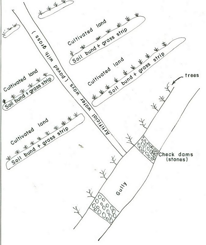
4.1 Desenho técnico da tecnologia
4.2 Especificações técnicas/ explicações do desenho técnico
SNNPR
Technical knowledge required for field staff / advisors: high
Technical knowledge required for land users: moderate
Main technical functions: control of dispersed runoff: retain / trap, control of dispersed runoff: impede / retard, increase of infiltration
Secondary technical functions: reduction of slope angle, reduction of slope length, increase / maintain water stored in soil
Early planting
Material/ species: maize, potato
Remarks: row and broad casting
Mixed cropping / intercropping
Material/ species: sorghum + haricot beans
Remarks: row planting
Agronomic measure: mixed cropping / intercropping
Material/ species: maize + haricot beans
Remarks: row planting
Agronomic measure: mixed cropping / intercropping
Material/ species: coffee + cabbage
Remarks: row planting
Legume inter-planting
Remarks: row and broad casting
Manure / compost / residues
Material/ species: animal dung
Remarks: broad casting
Breaking compacted topsoil
Remarks: once, along the contour
Contour tillage
Remarks: 3-6 times, along the contour
Aligned: -contour
Vegetative material: G : grass
Vertical interval between rows / strips / blocks (m): 1m
Vertical interval within rows / strips / blocks (m): 0.3
Width within rows / strips / blocks (m): 1
Scattered / dispersed
Vegetative material: T : trees / shrubs
Number of plants per (ha): 10-15
Vegetative measure: scattered/dispersed
Vegetative material: F : fruit trees / shrubs
Number of plants per (ha): 40-60
Vegetative measure: Vegetative material: F : fruit trees / shrubs
Vegetative measure: Vegetative material: F : fruit trees / shrubs
Vegetative measure: Vegetative material: F : fruit trees / shrubs
Trees/ shrubs species: Cordia, Croton, Ficus
Fruit trees / shrubs species: Casmir, Avocado, Mango
Perennial crops species: Chat, Coffee, Sugar cane, Papaya
Grass species: Desho, Phalaris
Slope (which determines the spacing indicated above): 15.00%
If the original slope has changed as a result of the Technology, the slope today is (see figure below): 10.00%
Gradient along the rows / strips: 0.00%
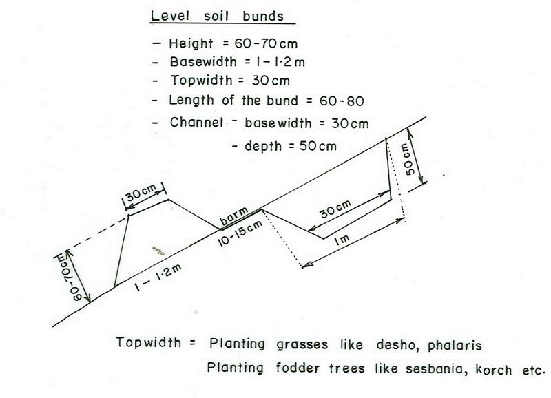
Terrace: bench level
Vertical interval between structures (m): 1
Spacing between structures (m): 10
Depth of ditches/pits/dams (m): 0.5
Width of ditches/pits/dams (m): 0.3
Length of ditches/pits/dams (m): 1
Height of bunds/banks/others (m): 0.6-0.7
Width of bunds/banks/others (m): 1-1.2
Length of bunds/banks/others (m): 60-80
Construction material (earth): Soils excavated from the ditches is used to make the embankment.
Construction material (stone): Stones collected to construct stone/stone faced bunds.
Slope (which determines the spacing indicated above): 15%
If the original slope has changed as a result of the Technology, the slope today is: 10%
Lateral gradient along the structure: 0%
Vegetation is used for stabilisation of structures.
Change of land use type: cut and carry system practiced
Other type of management: change of management / intensity level - Follow up and evaluating the performance
4.3 Informação geral em relação ao cálculo de entradas e custos
Outro/moeda nacional (especifique):
Birr
Indique a taxa cambial do dólar norte americano para a moeda local (se relevante): 1 USD =:
8,6
Indique a média salarial da mão-de-obra contratada por dia:
0.70
4.4 Atividades de implantação
| Atividade | Tipo de medida | Periodicidade | |
|---|---|---|---|
| 1. | Production of planting materials | Vegetativo | beginning of rains |
| 2. | Planting on the bund | Vegetativo | during rains |
| 3. | Survey | Estrutural | dry season |
| 4. | Excavating the ditches and constructing the enbankment | Estrutural | dry season |
| 5. | desho grass transportation | Estrutural | during rains |
| 6. | Planting Desho grass on the bund | Estrutural | during rains |
| 7. | Group formation | Gestão | dry season |
| 8. | Follow up and evaluating the activities | Gestão | throughout the year |
4.5 Custos e entradas necessárias para a implantação
| Especifique a entrada | Unidade | Quantidade | Custos por unidade | Custos totais por entrada | % dos custos arcados pelos usuários da terra | |
|---|---|---|---|---|---|---|
| Mão-de-obra | Labour | ha | 1,0 | 156,0 | 156,0 | 5,0 |
| Equipamento | Machine use | ha | 1,0 | 27,8 | 27,8 | |
| Equipamento | Tools | ha | 1,0 | 32,1 | 32,1 | 70,0 |
| Material vegetal | Seeds | ha | 1,0 | 27,0 | 27,0 | 100,0 |
| Material vegetal | Seedlings | ha | 1,0 | 29,0 | 29,0 | 100,0 |
| Outros | Grass | ha | 1,0 | 306,0 | 306,0 | 100,0 |
| Custos totais para a implantação da tecnologia | 577,9 | |||||
Comentários:
Duration of establishment phase: 24 month(s)
4.6 Atividades recorrentes/manutenção
| Atividade | Tipo de medida | Periodicidade/frequência | |
|---|---|---|---|
| 1. | Contour tillage | Agronômico | dry season / annual |
| 2. | Contour tillage | Agronômico | dry season / two to three times |
| 3. | Sawing | Agronômico | during rains / annual |
| 4. | Weeding | Agronômico | during rains / one or twice a year |
| 5. | Harvesting | Agronômico | dry season / annual |
| 6. | Replanting | Vegetativo | during rains /once |
| 7. | Reconstruction | Estrutural | dry season/annual |
| 8. | Replanting | Estrutural | rainy season/annual |
4.7 Custos e entradas necessárias pata a manutenção/atividades recorrentes (por ano)
| Especifique a entrada | Unidade | Quantidade | Custos por unidade | Custos totais por entrada | % dos custos arcados pelos usuários da terra | |
|---|---|---|---|---|---|---|
| Mão-de-obra | Labour | ha | 1,0 | 18,84 | 18,84 | 100,0 |
| Equipamento | Machine use | ha | 1,0 | 81,39 | 81,39 | 100,0 |
| Custos totais para a manutenção da tecnologia | 100,23 | |||||
Comentários:
Machinery/ tools: Shovel, hoe, water level, string
The cost is culculated per length of structure and other agricultural activities undertaken and the cost is in a hectare of land.
4.8 Fatores mais importantes que afetam os custos
Descreva os fatores mais determinantes que afetam os custos:
Type of hand tools, Slope of the land and soil depth.
5. Ambiente natural e humano
5.1 Clima
Precipitação pluviométrica anual
- <250 mm
- 251-500 mm
- 501-750 mm
- 751-1.000 mm
- 1.001-1.500 mm
- 1.501-2.000 mm
- 2.001-3.000 mm
- 3.001-4.000 mm
- > 4.000 mm
Especificações/comentários sobre a pluviosidade:
1001-1500 mm (Ranked 1): 900-1400 mm, rains are tremendously variable.
751-1000 mm (Ranked 2): 900 mm, Parts of the SWC area receives on an average 900 mm.
Zona agroclimática
- Subúmido
Very suitable to agricultural activities with variety crops grown.
5.2 Topografia
Declividade média:
- Plano (0-2%)
- Suave ondulado (3-5%)
- Ondulado (6-10%)
- Moderadamente ondulado (11-15%)
- Forte ondulado (16-30%)
- Montanhoso (31-60%)
- Escarpado (>60%)
Formas de relevo:
- Planalto/planície
- Cumes
- Encosta de serra
- Encosta de morro
- Sopés
- Fundos de vale
Zona de altitude:
- 0-100 m s.n.m.
- 101-500 m s.n.m.
- 501-1.000 m s.n.m.
- 1.001-1.500 m s.n.m.
- 1.501-2.000 m s.n.m.
- 2.001-2.500 m s.n.m.
- 2.501-3.000 m s.n.m.
- 3.001-4.000 m s.n.m.
- > 4.000 m s.n.m.
Comentários e outras especificações sobre a topografia:
Altitudinal zone: 2001-2500 m a.s.l. (Ranked 1, below 2400m asl, very suitable to wheat, barley and horse beans.) and 1501-2000 m a.s.l. (ranked 2, over 1900m asl, very suitable to cereal crops including maize)
Landforms: Hill slopes (ranked 1, dominant land forms with flatter village areas at the top) also, ridges (ranked 2) and plateau/plains (ranked 3)
Slopes on average: Rolling (Ranked 1, the technology is mostly implemented here), moderate (ranked 2, dominantly cultivated) and hilly (ranked 3, area enclosures) as well as gentle and steep (both ranked 3)
5.3 Solos
Profundidade do solo em média:
- Muito raso (0-20 cm)
- Raso (21-50 cm)
- Moderadamente profundo (51-80 cm)
- Profundo (81-120 cm)
- Muito profundo (>120 cm)
Textura do solo (solo superficial):
- Médio (limoso, siltoso)
- Fino/pesado (argila)
Matéria orgânica do solo superficial:
- Médio (1-3%)
- Baixo (<1%)
Caso disponível anexe a descrição completa do solo ou especifique as informações disponíveis, p. ex. tipo de solo, PH/acidez do solo, nitrogênio, capacidade de troca catiônica, salinidade, etc.
Soil depth on average: Also moderately deep (ranked 2, dominant soil depth in the SWC area) and shallow (ranked 3, degraded hillsides)
Soil texture: Fine/heavy (ranked 1, clay loam nitisols and vertisols) and medium (ranked 2, soils with high productivity)
Soil fertility: medium (ranked 1, most of the cereal cropped areas) and high (ranked 2, soils in the homestead)
Topsoil organic matter: Low (ranked 1, for all cereal cropped lands) and medium (ranked 2, land with perennial crops and homestead areas)
Soil drainage/infiltration: good (ranked 1, croplands on hillslopes ) and medium (ranked 2)
Soil water storage capacity: High (vertisols and soils on flat slopes)
5.6 Características dos usuários da terra que utilizam a tecnologia
Rendimento não agrícola:
- Menos de 10% de toda renda
Nível relativo de riqueza:
- Pobre
- Média
Nível de mecanização:
- Trabalho manual
- Tração animal
Indique outras características relevantes dos usuários da terra:
Population density: 200-500 persons/km2
Annual population growth: 2% - 3%
6% of the land users are rich and own 19% of the land.
35% of the land users are average wealthy and own 45% of the land.
45% of the land users are poor and own 15% of the land.
12% of the land users are poor and own 7% of the land.
Off-farm income specification: Land users who have SWC measures on their land have better income compared to others who do not have and they have better scope to get engaged in small trade.
Market orientation of production system: subsistence (cultivation and weeding of perennial crops done by hoe and weeding manual) and mixed (tillage is done by oxen)
5.7 Média da área de terra própria ou arrendada por usuários da terra que utilizam a tecnologia
- < 0,5 ha
- 0,5-1 ha
- 1-2 ha
- 2-5 ha
- 5-15 ha
- 15-50 ha
- 50-100 ha
- 100-500 ha
- 500-1.000 ha
- 1.000-10.000 ha
- > 10.000 ha
Comentários:
Most land users have 0.50-0.25 ha of land.
5.8 Propriedade de terra, direitos de uso da terra e de uso da água
Propriedade da terra:
- Estado
Direitos do uso da terra:
- Indivíduo
6. Impactos e declarações finais
6.1 Impactos no local mostrados pela tecnologia
Impactos socioeconômicos
Produção
Produção agrícola
Comentários/especificar:
soil loss reduced, fertilizers loss controlled
Produção de forragens
Comentários/especificar:
bund stablization increased feed availability
Qualidade da forragem
Comentários/especificar:
bund stablization increased feed availability
Produção de madeira
Comentários/especificar:
tree plantation
Área de produção
Comentários/especificar:
area occupied by the bund
Renda e custos
Rendimento agrícola
Comentários/especificar:
production per unit area increased
Impactos socioculturais
Instituições comunitárias
Comentários/especificar:
SWC activities organized and planned by communities
Instituições nacionais
Comentários/especificar:
government & NGOs involvement increased
Conhecimento de GST/ degradação da terra
Comentários/especificar:
more land users acquired knowledge on SWC
Impactos ecológicos
Ciclo hídrico/escoamento
Drenagem de excesso de água
Solo
Umidade do solo
Cobertura do solo
Comentários/especificar:
uphills planted with forest trees
Perda de solo
Quantidade anterior à GST:
82
Quantidade posterior à GST:
8
Comentários/especificar:
integrated measures
6.4 Análise do custo-benefício
Como os benefícios se comparam aos custos de implantação (do ponto de vista dos usuários da terra)?
Retornos a curto prazo:
levemente positivo
Retornos a longo prazo:
positivo
Como os benefícios se comparam aos custos recorrentes/de manutenção(do ponto de vista dos usuários da terra)?
Retornos a curto prazo:
levemente positivo
Retornos a longo prazo:
positivo
6.5 Adoção da tecnologia
Entre todos aqueles que adotaram a tecnologia, quantos adotaram espontaneamente, ou seja, sem receber nenhum incentivo material/pagamentos?
- 0-10%
Comentários:
10% of land user families have adopted the Technology with external material support
25600 land user families have adopted the Technology with external material support
Comments on acceptance with external material support: estimates
5% of land user families have adopted the Technology without any external material support
Comments on spontaneous adoption: estimates
There is a moderate trend towards spontaneous adoption of the Technology
Comments on adoption trend: Farmers have acquired some technical skills that enables them implement SWC measures by themselves on their own land with little external support.
6.7 Pontos fortes/vantagens/oportunidades da tecnologia
| Pontos fortes/vantagens/oportunidades na visão do usuário da terra |
|---|
|
increased crop production How can they be sustained / enhanced? use high yielding varities and better farming systems. |
| soil erosion reduced |
| Pontos fortes/vantagens/oportunidades na visão do compilador ou de outra pessoa capacitada |
|---|
|
soils protected from erosion How can they be sustained / enhanced? more awarness creation and strengthening maintenance |
|
sources of income diversified How can they be sustained / enhanced? introduce more productive multipurposive activities |
Links e módulos
Expandir tudo Recolher tudoLinks
Não há links
Módulos
Não há módulos