Soil Bund with Contour Cultivation [ອີທິໂອເປຍ]
- ການສ້າງ:
- ປັບປູງ:
- ຜູ້ສັງລວມຂໍ້ມູນ: Unknown User
- ບັນນາທິການ: –
- ຜູ້ທົບທວນຄືນ: Fabian Ottiger
Ditchira, Kab (Amharic)
technologies_1073 - ອີທິໂອເປຍ
ເບິ່ງພາກສ່ວນ
ຂະຫຍາຍທັງໝົດ ຍຸບທັງໝົດ1. ຂໍ້ມູນທົ່ວໄປ
1.2 ຂໍ້ມູນ ການຕິດຕໍ່ພົວພັນ ຂອງບຸກຄົນທີ່ສໍາຄັນ ແລະ ສະຖາບັນ ທີ່ມີສ່ວນຮ່ວມ ໃນການປະເມີນເອກກະສານ ເຕັກໂນໂລຢີ
ບັນດາຜູ້ຕອບແບບສອບຖາມທີ່ສໍາຄັນ ()
ຜຸ້ຊ່ຽວຊານ ດ້ານການຄຸ້ມຄອງ ທີ່ດິນແບບຍືນຍົງ:
Tafese Berhanu
0465552211
Hadiya zone
Hossana
ອີທິໂອເປຍ
ຜຸ້ຊ່ຽວຊານ ດ້ານການຄຸ້ມຄອງ ທີ່ດິນແບບຍືນຍົງ:
Watchiso Adibacho
0465552211
Hadiya zone
Hossana
ອີທິໂອເປຍ
1.3 ເງື່ອນໄຂ ກ່ຽວກັບ ການນໍາໃຊ້ຂໍ້ມູນເອກະສານ ທີ່ສ້າງຂື້ນ ໂດຍຜ່ານ ອົງການພາບລວມຂອງໂລກ ທາງດ້ານແນວທາງ ແລະ ເຕັກໂນໂລຢີ ຂອງການອານຸລັກ ທໍາມະຊາດ (WOCAT)
ເມື່ອໃດທີ່ໄດ້ສັງລວມຂໍ້ມູນ (ຢູ່ພາກສະໜາມ)?
30/05/2011
ຜູ້ປ້ອນຂໍ້ມູນ ແລະ ບຸກຄົນສຳຄັນ ທີ່ໃຫ້ຂໍ້ມູນ (ຫຼາຍ) ຍິນຍອມ ຕາມເງື່ອນໄຂ ໃນການນຳໃຊ້ຂໍ້ມູນ ເພື່ອສ້າງເປັນເອກກະສານຂອງ WOCAT:
ແມ່ນ
2. ການອະທິບາຍ ເຕັກໂນໂລຢີ ຂອງການຄຸ້ມຄອງ ທີ່ດິນແບບຍືນຍົງ
2.1 ຄໍາອະທິບາຍສັ້ນຂອງ ເຕັກໂນໂລຢີ
ການກຳໜົດຄວາມໝາຍ ຂອງເຕັກໂນໂລຢີ:
It is a structural measure with an embankment of soil or stones or soil and stones, constructed along the contour and stablized with vegetative measures (grass and fodder trees).
2.2 ການອະທິບາຍ ລາຍລະອຽດ ຂອງເຕັກໂນໂລຢີ
ການພັນລະນາ:
Applied on different land uses on slope of more than 3%. This practice is widely used by farmers in the area. Stone and stone faced bunds height depends on the availability of stones. On the average the width is 1-1.2m and hieght is 0.6-0.7m.
Purpose of the Technology: Bunds reduce the velocity of runoff and soil erosion, retains water behind the bund and let it infiltrate. It further helps in ground water recharging.
Establishment / maintenance activities and inputs: Planning is made by community/group and individual discussion and reach a consensus on layout, spacing, implementation modalities and management requirments is reached before implementation.
Natural / human environment: The technology is applicable in areas where soil is moderately deep and stones are available
2.3 ຮູບພາບຂອງເຕັກໂນໂລຢີ
ສື່ຮູບພາບ
2.5 ປະເທດ / ເຂດ / ສະຖານທີ່ບ່ອນທີ່ ເຕັກໂນໂລຢີ ໄດ້ຮັບການນໍາໃຊ້ ແລະ ທີ່ຖືກປົກຄຸມດ້ວຍການປະເມີນຜົນ
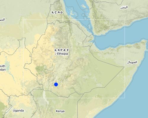
ປະເທດ:
ອີທິໂອເປຍ
ພາກພື້ນ / ລັດ / ແຂວງ:
SNNPR/Hadiya/Lemo
ຂໍ້ມູນເພີ່ມເຕີມຂອງສະຖານທີ່:
Lemo
Map
×2.6 ວັນທີໃນການຈັດຕັ້ງປະຕິບັດ
ຖ້າຫາກວ່າ ບໍ່ຮູ້ຈັກ ປີທີ່ຊັດເຈນ ແມ່ນໃຫ້ປະມານ ວັນທີເອົາ:
- ຫຼາຍກ່ອນ 50 ປີຜ່ານມາ (ແບບພື້ນບ້ານ)
2.7 ການນໍາສະເໜີ ເຕັກໂນໂລຢີ
ໃຫ້ລະບຸ ເຕັກໂນໂລຢີ ໄດ້ຖືກຈັດຕັ້ງປະຕິບັດຄືແນວໃດ?
- ໂດຍຜ່ານໂຄງການ / ການຊ່ວຍເຫຼືອຈາກພາຍນອກ
ຄວາມຄິດເຫັນ (ປະເພດ ໂຄງການ ແລະ ອື່ນໆ):
Other countries and also other woredas in the country.
3. ການໃຈ້ແຍກ ເຕັກໂນໂລຢີ ໃນການຄຸ້ມຄອງ ດິນແບບຍືນຍົງ
3.2 ປະເພດການນໍາໃຊ້ທີ່ດິນ ໃນປະຈຸບັນ() ທີ່ເຕັກໂນໂລຢີ ໄດ້ຖືກນໍາໃຊ້

ດິນທີ່ປູກພືດ
- ການປູກພືດປະຈໍາປີ
- ພືດຢືນຕົ້ນ (ບໍ່ແມ່ນໄມ້)
- ເປັນໄມ້ຢືນຕົ້ນ ແລະ ໄມ້ພຸ່ມ ຈາກການປູກພືດ
ການປູກພືດຫຼັກ (ທີ່ສາມາດສ້າງລັບຮັບ ເປັນເງິນສົດ ແລະ ເປັນພືດສະບຽງອາຫານ):
Major cash crop annual cropping: Wheat
Major food crop annual cropping: Maize
Major cash crop perennial (non-woody) cropping: sugar cane
Major food crop perennial (non-woody) cropping: sugar cane
Major cash crop perennial tree/shrub cropping: coffee, Enset
Major food crop perennial tree/shrub cropping: sugar cane

ປ່າໄມ້ / ປ່າ
ຜົນຜະລິດ ແລະ ການບໍລິການ:
- ເຄື່ອງປ່າຂອງດົງ
- ໄມ້ຟືນ
- ທົ່ງຫຍ້າ
ຄວາມຄິດເຫັນ:
Major land use problems (compiler’s opinion): Absence of land use policy, low level of awarness, shortage of farm lands.
Major land use problems (land users’ perception): Continous cultivation, poor soil fertility, poverty, shortage of cultivated lands.
Plantation forestry: Yes
Problems / comments regarding forest use: Many peasant kebeles have earned money by selling eucalyptus grown on plantation areas of the community. Some have built schools from the proceeds. Some kebeles have shared sizable money from the sales of trees.
Type of cropping system and major crops comments: Cereals - legumes - cereals
3.3 ຂໍ້ມູນເພີ່ມເຕີມກ່ຽວກັບການນໍາໃຊ້ທີ່ດິນ
ການສະໜອງນໍ້າ ໃນພື້ນທີ່ ທີ່ໄດ້ນໍາໃຊ້ ເຕັກໂນໂລຢີ:
- ນໍ້າຝົນ
ຈໍານວນ ລະດູການ ປູກໃນປີໜຶ່ງ:
- 2
ລະບຸ ຊະນິດ:
Longest growing period in days: 180 Longest growing period from month to month: Apr - Nov Second longest growing period in days: 150
3.4 ການນໍາໃຊ້ເຕັກໂນໂລຢີ ທີ່ຢູ່ໃນກຸ່ມການຄຸ້ມຄອງ ທີ່ດິນແບບຍືນຍົງ
- ມາດຕະການ ຕັດຂວາງ ກັບຄວາມຄ້ອຍຊັນ
3.5 ການຂະຫຍາຍເຕັກໂນໂລຢີ
ຄວາມຄິດເຫັນ:
Total area covered by the SLM Technology is 173 m2.
Nowadays communities have developed positive attitudes towards SWC technologies implemented and the results obtained by practicing measures, which have reduced runoff and soil erosion reduced and land increased productivity.
3.6 ມາດຕະການ ການຄຸ້ມຄອງ ທີ່ດິນແບບຍືນຍົງ ປະກອບດ້ວຍ ເຕັກໂນໂລຢີ
3.7 ປະເພດດິນເຊື່ອມໂຊມ ຫຼັກທີ່ໄດ້ນໍາໃຊ້ ເຕັກໂນໂລຢີ

ດິນເຊາະເຈື່ອນ ໂດຍນໍ້າ
- Wt: ການສູນເສຍຊັ້ນໜ້າດິນ / ການເຊາະເຈື່ອນຜິວໜ້າດິນ
- Wg: ການເຊາະເຈື່ອນຮ່ອງນ້ຳ / ຫ້ວຍ

ການເຊື່ອມໂຊມ ຂອງດິນ ທາງເຄມີ
- Cn: ຄວາມອຸດົມສົມບູນ ລົດໜ້ອຍຖອຍລົງ ແລະ ສານອິນຊີວັດຖຸລົດລົງ (ບໍ່ແມ່ນສາເຫດມາຈາກການເຊາະເຈື່ອນ)
ຄວາມຄິດເຫັນ:
Main type of degradation addressed: Wt: loss of topsoil / surface erosion
Secondary types of degradation addressed: Wg: gully erosion / gullying, Cn: fertility decline and reduced organic matter content
3.8 ການປ້ອງກັນ, ການຫຼຸດຜ່ອນ, ຫຼືການຟື້ນຟູຂອງການເຊື່ອມໂຊມຂອງດິນ
ໃຫ້ລະບຸ ເປົ້າໝາຍ ເຕັກໂນໂລຢີ ທີ່ພົວພັນ ກັບຄວາມເຊື່ອມໂຊມຂອງດິນ:
- ປ້ອງກັນການເຊື່ອມໂຊມຂອງດິນ
- ຫຼຸດຜ່ອນການເຊື່ອມໂຊມຂອງດິນ
ຄວາມຄິດເຫັນ:
Secondary goals: Rehabilitation / reclamation of denuded land
4. ຂໍ້ກໍາໜົດ, ກິດຈະກໍາການປະຕິບັດ, ວັດຖຸດິບ, ແລະຄ່າໃຊ້ຈ່າຍ
4.1 ເຕັກນິກ ໃນການແຕ້ມແຜນວາດ ເຕັກໂນໂລຢີ
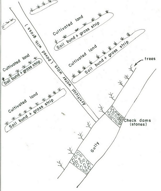
4.2 ການແຕ້ມແຜນວາດອະທິບາຍເຕັກນິກ
SNNPR
Technical knowledge required for field staff / advisors: high
Technical knowledge required for land users: moderate
Main technical functions: control of dispersed runoff: retain / trap, control of dispersed runoff: impede / retard, increase of infiltration
Secondary technical functions: reduction of slope angle, reduction of slope length, increase / maintain water stored in soil
Early planting
Material/ species: maize, potato
Remarks: row and broad casting
Mixed cropping / intercropping
Material/ species: sorghum + haricot beans
Remarks: row planting
Agronomic measure: mixed cropping / intercropping
Material/ species: maize + haricot beans
Remarks: row planting
Agronomic measure: mixed cropping / intercropping
Material/ species: coffee + cabbage
Remarks: row planting
Legume inter-planting
Remarks: row and broad casting
Manure / compost / residues
Material/ species: animal dung
Remarks: broad casting
Breaking compacted topsoil
Remarks: once, along the contour
Contour tillage
Remarks: 3-6 times, along the contour
Aligned: -contour
Vegetative material: G : grass
Vertical interval between rows / strips / blocks (m): 1m
Vertical interval within rows / strips / blocks (m): 0.3
Width within rows / strips / blocks (m): 1
Scattered / dispersed
Vegetative material: T : trees / shrubs
Number of plants per (ha): 10-15
Vegetative measure: scattered/dispersed
Vegetative material: F : fruit trees / shrubs
Number of plants per (ha): 40-60
Vegetative measure: Vegetative material: F : fruit trees / shrubs
Vegetative measure: Vegetative material: F : fruit trees / shrubs
Vegetative measure: Vegetative material: F : fruit trees / shrubs
Trees/ shrubs species: Cordia, Croton, Ficus
Fruit trees / shrubs species: Casmir, Avocado, Mango
Perennial crops species: Chat, Coffee, Sugar cane, Papaya
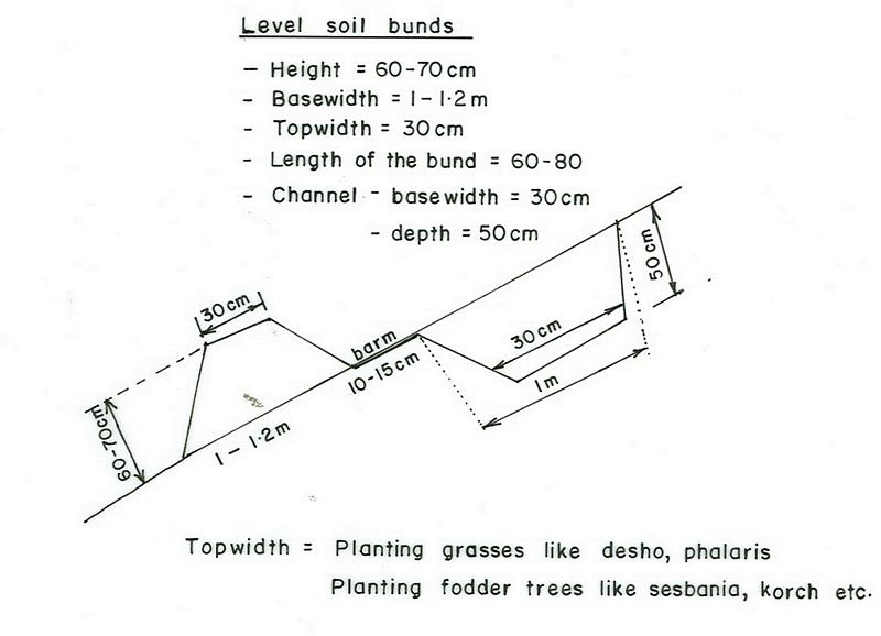
Grass species: Desho, Phalaris
Slope (which determines the spacing indicated above): 15.00%
If the original slope has changed as a result of the Technology, the slope today is (see figure below): 10.00%
Gradient along the rows / strips: 0.00%
Terrace: bench level
Vertical interval between structures (m): 1
Spacing between structures (m): 10
Depth of ditches/pits/dams (m): 0.5
Width of ditches/pits/dams (m): 0.3
Length of ditches/pits/dams (m): 1
Height of bunds/banks/others (m): 0.6-0.7
Width of bunds/banks/others (m): 1-1.2
Length of bunds/banks/others (m): 60-80
Construction material (earth): Soils excavated from the ditches is used to make the embankment.
Construction material (stone): Stones collected to construct stone/stone faced bunds.
Slope (which determines the spacing indicated above): 15%
If the original slope has changed as a result of the Technology, the slope today is: 10%
Lateral gradient along the structure: 0%
Vegetation is used for stabilisation of structures.
Change of land use type: cut and carry system practiced
Other type of management: change of management / intensity level - Follow up and evaluating the performance
4.3 ຂໍ້ມູນທົ່ວໄປກ່ຽວກັບການຄິດໄລ່ປັດໃຈຂາເຂົ້າໃນການຜະລິດ ແລະ ມູນຄ່າອື່ນໆ
ສະກຸນເງິນອື່ນໆ / ປະເທດອື່ນໆ (ລະບຸ):
Birr
ລະບຸ ອັດຕາແລກປ່ຽນ ຈາກໂດລາ ເປັນເງິນຕາທ້ອງຖີ່ນ (ຖ້າກ່ຽວຂ້ອງ): 1 ໂດລາ =:
8.6
ລະບຸ ຄ່າຈ້າງ ຄ່າແຮງງານສະເລ່ຍ ຕໍ່ ວັນ:
0.70
4.4 ການສ້າງຕັ້ງກິດຈະກໍາ
| ກິດຈະກໍາ | ປະເພດ ມາດຕະການ | ໄລຍະເວລາ | |
|---|---|---|---|
| 1. | Production of planting materials | ການບໍາລຸງລ້ຽງ | beginning of rains |
| 2. | Planting on the bund | ການບໍາລຸງລ້ຽງ | during rains |
| 3. | Survey | ໂຄງສ້າງ | dry season |
| 4. | Excavating the ditches and constructing the enbankment | ໂຄງສ້າງ | dry season |
| 5. | desho grass transportation | ໂຄງສ້າງ | during rains |
| 6. | Planting Desho grass on the bund | ໂຄງສ້າງ | during rains |
| 7. | Group formation | ການຈັດການຄຸ້ມຄອງ | dry season |
| 8. | Follow up and evaluating the activities | ການຈັດການຄຸ້ມຄອງ | throughout the year |
4.5 ຕົ້ນທຶນ ແລະ ປັດໄຈຂາເຂົ້າທີ່ຈໍາເປັນໃນຈັດຕັ້ງປະຕິບັດ
| ລະບຸ ປັດໃຈ ນໍາເຂົ້າ ໃນການຜະລີດ | ຫົວໜ່ວຍ | ປະລິມານ | ຕົ້ນທຶນ ຕໍ່ຫົວໜ່ວຍ | ຕົ້ນທຶນທັງໝົດ ຂອງປັດໃຈຂາເຂົ້າ ໃນການຜະລິດ | % ຂອງຕົ້ນທຶນທັງໝົດ ທີ່ຜູ້ນໍາໃຊ້ທີ່ດິນ ໃຊ້ຈ່າຍເອງ | |
|---|---|---|---|---|---|---|
| ແຮງງານ | Labour | ha | 1.0 | 156.0 | 156.0 | 5.0 |
| ອຸປະກອນ | Machine use | ha | 1.0 | 27.8 | 27.8 | |
| ອຸປະກອນ | Tools | ha | 1.0 | 32.1 | 32.1 | 70.0 |
| ວັດສະດຸໃນການປູກ | Seeds | ha | 1.0 | 27.0 | 27.0 | 100.0 |
| ວັດສະດຸໃນການປູກ | Seedlings | ha | 1.0 | 29.0 | 29.0 | 100.0 |
| ອື່ນໆ | Grass | ha | 1.0 | 306.0 | 306.0 | 100.0 |
| ຕົ້ນທຶນທັງໝົດ ໃນການຈັດຕັ້ງປະຕິບັດ ເຕັກໂນໂລຢີ | 577.9 | |||||
ຄວາມຄິດເຫັນ:
Duration of establishment phase: 24 month(s)
4.6 ບໍາລຸງຮັກສາ / ແຜນຈັດຕັ້ງປະຕິບັດ ກິດຈະກໍາ
| ກິດຈະກໍາ | ປະເພດ ມາດຕະການ | ໄລຍະເວລາ / ຄວາມຖີ່ | |
|---|---|---|---|
| 1. | Contour tillage | ພືດ | dry season / annual |
| 2. | Contour tillage | ພືດ | dry season / two to three times |
| 3. | Sawing | ພືດ | during rains / annual |
| 4. | Weeding | ພືດ | during rains / one or twice a year |
| 5. | Harvesting | ພືດ | dry season / annual |
| 6. | Replanting | ການບໍາລຸງລ້ຽງ | during rains /once |
| 7. | Reconstruction | ໂຄງສ້າງ | dry season/annual |
| 8. | Replanting | ໂຄງສ້າງ | rainy season/annual |
4.7 ຄ່າໃຊ້ຈ່າຍ ແລະ ປັດໄຈນໍາເຂົ້າທີ່ຈໍາເປັນສໍາລັບການບໍາລຸງຮັກສາກິດຈະກໍາ / ແຜນປະຕິບັດ (ຕໍ່ປີ)
| ລະບຸ ປັດໃຈ ນໍາເຂົ້າ ໃນການຜະລີດ | ຫົວໜ່ວຍ | ປະລິມານ | ຕົ້ນທຶນ ຕໍ່ຫົວໜ່ວຍ | ຕົ້ນທຶນທັງໝົດ ຂອງປັດໃຈຂາເຂົ້າ ໃນການຜະລິດ | % ຂອງຕົ້ນທຶນທັງໝົດ ທີ່ຜູ້ນໍາໃຊ້ທີ່ດິນ ໃຊ້ຈ່າຍເອງ | |
|---|---|---|---|---|---|---|
| ແຮງງານ | Labour | ha | 1.0 | 18.84 | 18.84 | 100.0 |
| ອຸປະກອນ | Machine use | ha | 1.0 | 81.39 | 81.39 | 100.0 |
| ຕົ້ນທຶນທັງໝົດ ທີ່ໃຊ້ໃນການບໍາລຸງຮັກສາ ເຕັກໂນໂລຢີ | 100.23 | |||||
ຄວາມຄິດເຫັນ:
Machinery/ tools: Shovel, hoe, water level, string
The cost is culculated per length of structure and other agricultural activities undertaken and the cost is in a hectare of land.
4.8 ປັດໄຈ ທີ່ສໍາຄັນ ທີ່ສົ່ງຜົນກະທົບ ຕໍ່ຄ່າໃຊ້ຈ່າຍ
ໃຫ້ອະທິບາຍ ປັດໃຈ ທີ່ສົ່ງຜົນກະທົບ ຕໍ່ຕົ້ນທຶນ ໃນການຈັດຕັ້ງປະຕິບັດ:
Type of hand tools, Slope of the land and soil depth.
5. ສະພາບແວດລ້ອມທໍາມະຊາດ ແລະ ມະນຸດ
5.1 ອາກາດ
ປະລິມານນໍ້າຝົນປະຈໍາປີ
- < 250 ມີລິແມັດ
- 251-500 ມີລິແມັດ
- 501-750 ມີລິແມັດ
- 751-1,000 ມີລິແມັດ
- 1,001-1,500 ມີລິແມັດ
- 1,501-2,000 ມີລິແມັດ
- 2,001-3,000 ມີລິແມັດ
- 3,001-4,000 ມີລິແມັດ
- > 4,000 ມີລິແມັດ
ຂໍ້ມູນສະເພາະ / ຄວາມເຫັນກ່ຽວກັບ ປະລິມານນໍ້າຝົນ:
1001-1500 mm (Ranked 1): 900-1400 mm, rains are tremendously variable.
751-1000 mm (Ranked 2): 900 mm, Parts of the SWC area receives on an average 900 mm.
ເຂດສະພາບອາກາດກະສິກໍາ
- ເຄີ່ງຄວາມຊຸ່ມ
Very suitable to agricultural activities with variety crops grown.
5.2 ພູມິປະເທດ
ຄ່າສະເລ່ຍ ຄວາມຄ້ອຍຊັນ:
- ພື້ນທີ່ຮາບພຽງ (0-2%)
- ອ່ອນ (3-5 %)
- ປານກາງ (6-10 %)
- ມ້ວນ (11-15 %)
- ເນີນ(16-30%)
- ໍຊັນ (31-60%)
- ຊັນຫຼາຍ (>60%)
ຮູບແບບຂອງດິນ:
- ພູພຽງ / ທົ່ງພຽງ
- ສັນພູ
- ເປີ້ນພູ
- ເນີນພູ
- ຕີນພູ
- ຮ່ອມພູ
ເຂດລະດັບສູງ:
- 0-100 ແມັດ a.s.l.
- 101-500 ແມັດ a.s.l.
- 501-1,000 ແມັດ a.s.l.
- 1,001-1,500 ແມັດ a.s.l.
- 1,501-2,000 ແມັດ a.s.l.
- 2,001-2,500 ແມັດ a.s.l.
- 2,501-3,000 ແມັດ a.s.l.
- 3,001-4,000 ແມັດ a.s.l.
- > 4,000 ແມັດ a.s.l.
ຄຳເຫັນ ແລະ ຂໍ້ມູນສະເພາະ ເພີ່ມເຕີມ ກ່ຽວກັບ ພູມີປະເທດ:
Altitudinal zone: 2001-2500 m a.s.l. (Ranked 1, below 2400m asl, very suitable to wheat, barley and horse beans.) and 1501-2000 m a.s.l. (ranked 2, over 1900m asl, very suitable to cereal crops including maize)
Landforms: Hill slopes (ranked 1, dominant land forms with flatter village areas at the top) also, ridges (ranked 2) and plateau/plains (ranked 3)
Slopes on average: Rolling (Ranked 1, the technology is mostly implemented here), moderate (ranked 2, dominantly cultivated) and hilly (ranked 3, area enclosures) as well as gentle and steep (both ranked 3)
5.3 ດິນ
ຄວາມເລິກ ຂອງດິນສະເລ່ຍ:
- ຕື້ນຫຼາຍ (0-20 ຊັງຕີແມັດ)
- ຕື້ນ (21-50 ຊຕມ)
- ເລີກປານກາງ (51-80 ຊຕມ)
- ເລິກ (81-120 ຊມ)
- ເລິກຫຼາຍ (> 120 cm)
ເນື້ອດິນ (ໜ້າດິນ):
- ປານກາງ (ດິນໜຽວ, ດິນໂຄນ)
- ບາງລະອຽດ / ໜັກ (ໜຽວ)
ຊັ້ນອິນຊີວັດຖຸ ເທິງໜ້າດິນ:
- ປານກາງ (1-3 %)
- ຕໍາ່ (<1 %)
ຖ້າເປັນໄປໄດ້ ແມ່ນໃຫ້ຕິດຄັດ ການພັນລະນາດິນ ຫຼື ຂໍ້ມູນສະເພາະຂອງດິນ, ຕົວຢ່າງ, ຄຸນລັກສະນະ ປະເພດຂອງດິນ, ຄ່າຄວາມເປັນກົດ / ເປັນດ່າງຂອງດິນ, ສານອາຫານ, ດິນເຄັມ ແລະ ອື່ນໆ.
Soil depth on average: Also moderately deep (ranked 2, dominant soil depth in the SWC area) and shallow (ranked 3, degraded hillsides)
Soil texture: Fine/heavy (ranked 1, clay loam nitisols and vertisols) and medium (ranked 2, soils with high productivity)
Soil fertility: medium (ranked 1, most of the cereal cropped areas) and high (ranked 2, soils in the homestead)
Topsoil organic matter: Low (ranked 1, for all cereal cropped lands) and medium (ranked 2, land with perennial crops and homestead areas)
Soil drainage/infiltration: good (ranked 1, croplands on hillslopes ) and medium (ranked 2)
Soil water storage capacity: High (vertisols and soils on flat slopes)
5.6 ຄຸນລັກສະນະ ຂອງຜູ້ນໍາໃຊ້ທີ່ດິນ ທີ່ໄດ້ນໍາໃຊ້ເຕັກໂນໂລຢີ
ລາຍຮັບ ທີ່ບໍ່ໄດ້ມາຈາກ ການຜະລິດ ກະສິກໍາ:
- ໜ້ອຍກ່ວາ 10 % ຂອງລາຍຮັບທັງໝົດ
ລະດັບຄວາມຮັ່ງມີ:
- ທຸກຍາກ
- ສະເລ່ຍ
ລະດັບ ການຫັນເປັນກົນຈັກ:
- ການໃຊ້ແຮງງານຄົນ
- ສັດລາກແກ່
ໃຫ້ລະບຸ ຄຸນລັກສະນະ ຂອງຜູ້ນໍາໃຊ້ທີ່ດິນ:
Population density: 200-500 persons/km2
Annual population growth: 2% - 3%
6% of the land users are rich and own 19% of the land.
35% of the land users are average wealthy and own 45% of the land.
45% of the land users are poor and own 15% of the land.
12% of the land users are poor and own 7% of the land.
Off-farm income specification: Land users who have SWC measures on their land have better income compared to others who do not have and they have better scope to get engaged in small trade.
Market orientation of production system: subsistence (cultivation and weeding of perennial crops done by hoe and weeding manual) and mixed (tillage is done by oxen)
5.7 ພື້ນທີ່ສະເລ່ຍຂອງທີ່ດິນ ຫຼື ເຊົ່າໂດຍຜູ້ໃຊ້ທີ່ດິນການນໍາໃຊ້ ເຕັກໂນໂລຢີ
- <0.5 ເຮັກຕາ
- 0.5-1 ເຮັກຕາ
- 1-2 ເຮັກຕາ
- 2-5 ເຮັກຕາ
- 5-15 ເຮັກຕາ
- 15-50 ເຮັກຕາ
- 50-100 ເຮັກຕາ
- 100-500 ເຮັກຕາ
- 500-1,000 ເຮັກຕາ
- 1,000-10,000 ເຮັກຕາ
- > 10,000 ເຮັກຕາ
ຄວາມຄິດເຫັນ:
Most land users have 0.50-0.25 ha of land.
5.8 ເຈົ້າຂອງທີ່ດິນ, ສິດໃຊ້ທີ່ດິນ, ແລະ ສິດທິການນໍາໃຊ້ນໍ້າ
ເຈົ້າຂອງດິນ:
- ລັດ
ສິດທິ ໃນການນໍາໃຊ້ທີ່ດິນ:
- ບຸກຄົນ
6. ຜົນກະທົບ ແລະ ລາຍງານສະຫຼຸບ
6.1 ການສະແດງຜົນກະທົບ ພາຍໃນພື້ນທີ່ ທີ່ໄດ້ຈັດຕັ້ງປະຕິບັດ ເຕັກໂນໂລຢີ
ຜົນກະທົບທາງເສດຖະກິດສັງຄົມ
ການຜະລິດ
ການຜະລິດພືດ
ຄວາມຄິດເຫັນ / ລະບຸແຈ້ງ:
soil loss reduced, fertilizers loss controlled
ການຜະລິດອາຫານສັດ
ຄວາມຄິດເຫັນ / ລະບຸແຈ້ງ:
bund stablization increased feed availability
ຄຸນນະພາບຂອງອາຫານສັດ
ຄວາມຄິດເຫັນ / ລະບຸແຈ້ງ:
bund stablization increased feed availability
ຜົນຜະລິດໄມ້
ຄວາມຄິດເຫັນ / ລະບຸແຈ້ງ:
tree plantation
ເນື້ອທີ່ການຜະລິດ
ຄວາມຄິດເຫັນ / ລະບຸແຈ້ງ:
area occupied by the bund
ລາຍໄດ້ ແລະ ຄ່າໃຊ້ຈ່າຍ
ລາຍຮັບ ຈາກການຜະລີດ
ຄວາມຄິດເຫັນ / ລະບຸແຈ້ງ:
production per unit area increased
ຜົນກະທົບດ້ານວັດທະນາທໍາສັງຄົມ
ສະຖາບັນ ການຈັດຕັ້ງຊຸມຊົນ
ຄວາມຄິດເຫັນ / ລະບຸແຈ້ງ:
SWC activities organized and planned by communities
ສະຖາບັນແຫ່ງຊາດ
ຄວາມຄິດເຫັນ / ລະບຸແຈ້ງ:
government & NGOs involvement increased
ຄວາມຮູ້ກ່ຽວກັບ ການຄຸ້ມຄອງ ທີ່ດິນແບບຍືນຍົງ / ການເຊື່ອມໂຊມຂອງດິນ
ຄວາມຄິດເຫັນ / ລະບຸແຈ້ງ:
more land users acquired knowledge on SWC
ຜົນກະທົບຕໍ່ລະບົບນິເວດ
ວົງຈອນນໍ້າ / ນໍ້າ
ການລະບາຍນໍ້າ
ດິນ
ຄວາມຊຸ່ມຂອງດິນ
ການປົກຄຸມຂອງດິນ
ຄວາມຄິດເຫັນ / ລະບຸແຈ້ງ:
uphills planted with forest trees
ການສູນເສຍດິນ
ປະລິມານ ກ່ອນການຈັດຕັ້ງປະຕິບັດ ການຄຸ້ມຄອງ ທີ່ດິນແບບຍືນຍົງ:
82
ປະລີມານ ຫຼັງການຈັດຕັ້ງປະຕິບັດ ການຄຸ້ມຄອງ ທີ່ດິນແບບຍືນຍົງ:
8
ຄວາມຄິດເຫັນ / ລະບຸແຈ້ງ:
integrated measures
6.4 ການວິເຄາະຕົ້ນທຶນ ແລະ ຜົນປະໂຫຍດ
ຈະເຮັດປະໂຫຍດເພື່ອປຽບທຽບກັບຄ່າໃຊ້ຈ່າຍກັບສິ່ງກໍ່ສ້າງ (ຈາກທັດສະນະຂອງຜູ້ນຳໃຊ້ທີ່ດິນ) ໄດ້ແນວໃດ?
ຜົນຕອບແທນ ໃນໄລຍະສັ້ນ:
ຜົນກະທົບທາງບວກເລັກນ້ອຍ
ຜົນຕອບແທນ ໃນໄລຍະຍາວ:
ຜົນກະທົບທາງບວກ
ຈະໄດ້ຮັບຜົນປະໂຫຍດເມື່ອປຽບທຽບກັບ / ຄ່າໃຊ້ຈ່າຍໃນການບຳລຸງຮັກສາທີເ່ກີດຂື້ນອິກ (ຈາກທັດສະນະຄະຕິຂອງຜູ້ນຳໃຊ້ທີ່ດິນ) ໄດ້ແນວໃດ?
ຜົນຕອບແທນ ໃນໄລຍະສັ້ນ:
ຜົນກະທົບທາງບວກເລັກນ້ອຍ
ຜົນຕອບແທນ ໃນໄລຍະຍາວ:
ຜົນກະທົບທາງບວກ
6.5 ການປັບຕົວຮັບເອົາເຕັກໂນໂລຢີ
ທັງໝົດນັ້ນ ແມ່ນໃຜ ທີ່ເປັນຜູ້ປັບຕົວ ໃນການນໍາໃຊ້ ເຕັກໂນໂລຢີ, ມີຈັກຄົນ ທີ່ສາມາດເຮັດເອງໄດ້, ຕົວຢ່າງ, ປາດສະຈາກ ການຊ່ວຍເຫຼືອ ທາງດ້ານອຸປະກອນ / ການຈ່າຍເປັນເງິນ?
- 0-10%
ຄວາມຄິດເຫັນ:
10% of land user families have adopted the Technology with external material support
25600 land user families have adopted the Technology with external material support
Comments on acceptance with external material support: estimates
5% of land user families have adopted the Technology without any external material support
Comments on spontaneous adoption: estimates
There is a moderate trend towards spontaneous adoption of the Technology
Comments on adoption trend: Farmers have acquired some technical skills that enables them implement SWC measures by themselves on their own land with little external support.
6.7 ຈຸດແຂງ / ຂໍ້ດີ / ໂອກາດ ໃນການນໍາໃຊ້ ເຕັກໂນໂລຢີ
| ຈຸດແຂງ / ຂໍ້ດີ / ໂອກາດໃນການນໍາໃຊ້ທີ່ດິນ |
|---|
|
increased crop production How can they be sustained / enhanced? use high yielding varities and better farming systems. |
| soil erosion reduced |
| ຈຸດແຂງ / ຈຸດດີ / ໂອກາດ ຈາກທັດສະນະຂອງຜູ້ປ້ອນຂໍ້ມູນ ຫຼື ບຸກຄົນສຳຄັນ |
|---|
|
soils protected from erosion How can they be sustained / enhanced? more awarness creation and strengthening maintenance |
|
sources of income diversified How can they be sustained / enhanced? introduce more productive multipurposive activities |
ຂໍ້ມູນການເຊື່ອມຕໍ່ ແລະ ເນື້ອໃນ
ຂະຫຍາຍທັງໝົດ ຍຸບທັງໝົດການເຊື່ອມຕໍ່
ບໍ່ມີຂໍ້ມູນການເຊື່ອມຕໍ່
ເນື້ອໃນ
ບໍ່ມີເນື້ອໃນ