Gully control and catchment protection [Estado Plurinacional da Bolívia]
- Criação:
- Atualização:
- Compilador/a: Georg Heim
- Editor: –
- Revisor: Fabian Ottiger
Control de cárcavas (spanish)
technologies_1350 - Estado Plurinacional da Bolívia
Veja as seções
Expandir tudo Recolher tudo1. Informação geral
1.2 Detalhes do contato das pessoas capacitadas e instituições envolvidas na avaliação e documentação da tecnologia
Especialista em GST:
Vargas Ivan
Cochabamba
Estado Plurinacional da Bolívia
Nome do projeto que facilitou a documentação/avaliação da Tecnologia (se relevante)
Book project: where the land is greener - Case Studies and Analysis of Soil and Water Conservation Initiatives Worldwide (where the land is greener)Nome da(s) instituição(ões) que facilitou(ram) a documentação/ avaliação da Tecnologia (se relevante)
GEOTEST AG (GEOTEST AG) - Suíça1.3 Condições em relação ao uso da informação documentada através de WOCAT
Quando os dados foram compilados (no campo)?
01/09/2003
O/a compilador/a e a(s) pessoa(s) capacitada(s) aceitam as condições relativas ao uso de dados documentados através da WOCAT:
Sim
1.5 Referência ao(s) questionário(s) sobre as abordagens da GST
Incentive-based catchment treatment [Estado Plurinacional da Bolívia]
A project supported, incentive-based approach: farmers are sensitised about erosion, and involved in gully control and other measures to protect catchments.
- Compilador/a: Unknown User
2. Descrição da tecnologia de GST
2.1 Descrição curta da tecnologia
Definição da tecnologia:
Integrated gully treatment consisting of several simple practices including stone and wooden check dams, cut-off drains and reforestation in sediment traps (biotrampas).
2.2 Descrição detalhada da tecnologia
Descrição:
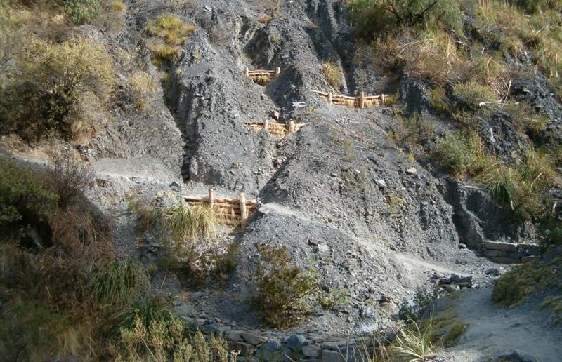
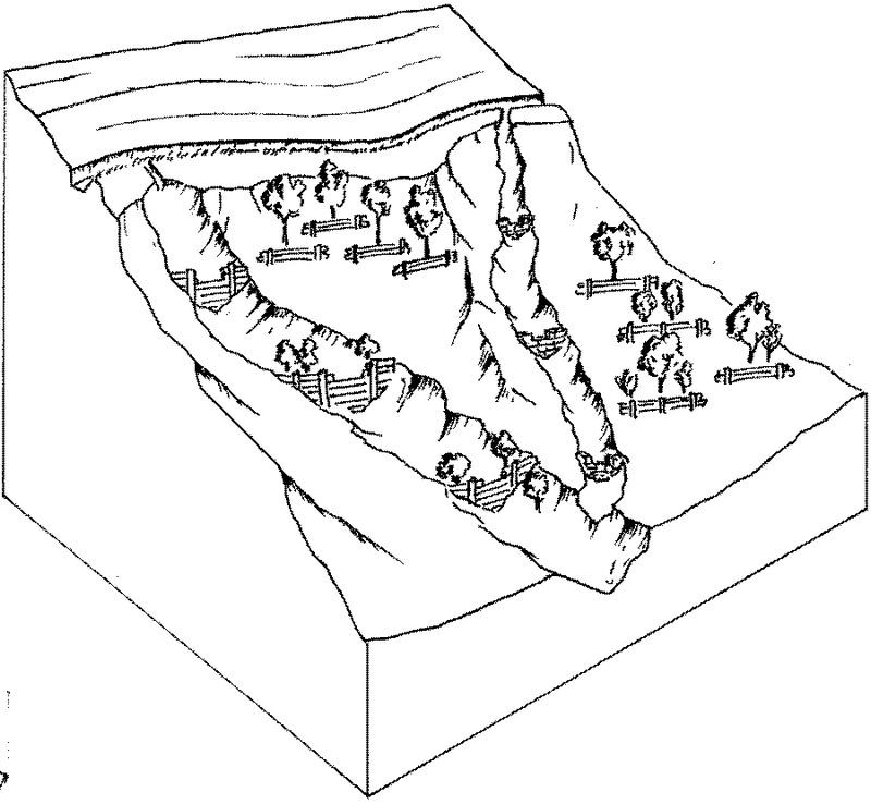
The focus of the case study is a degraded catchment, located at high altitude (2,800–4,200 m a.s.l.), home to 37 households, which is characterised by severe gullies and landslides. Gullies are continuously expanding, and constitute a significant proportion of the catchment. These cause considerable loss of cropland as well as downstream damage to the city of Cochabamba.
A combination of structural and vegetative measures was designed and implemented with the purpose of: (1) preventing affected areas from further degradation by safely discharging runoff from the surrounding area through the main gullies down to the valley; (2) gradually stabilising the land through the regeneration of vegetative cover; (3) reducing downstream damage through floods and siltation; (4) ensuring accessibility to the mountainous agricultural area during the rainy season.
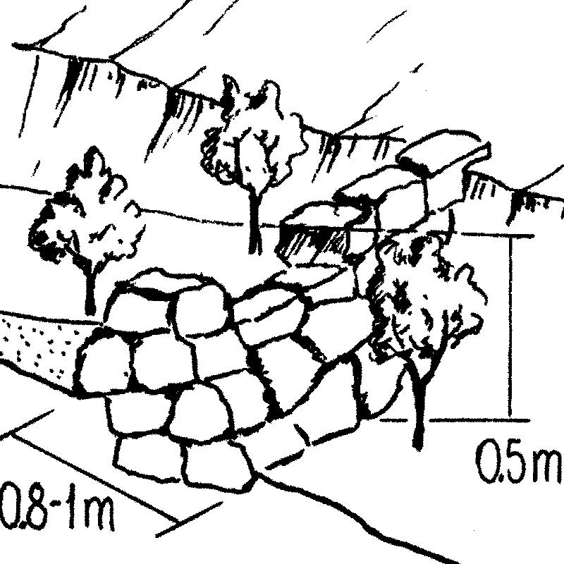
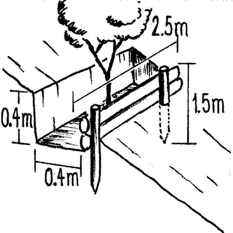
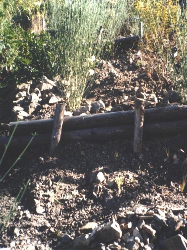
Cut-off drains at the heads of the gullies, reinforced with stones inside the channel and grassed bunds below, concentrate runoff and cascade it down over stone steps back into the waterways. Flow is controlled by stone and wooden check dams and discharged safely. Sediment is trapped behind these structures and terraces develop. Bushes or trees are planted above and below the check dams. Depending on availability of materials, wooden check dams are sometimes used and associated with tree planting (four trees above and four below each check dam).
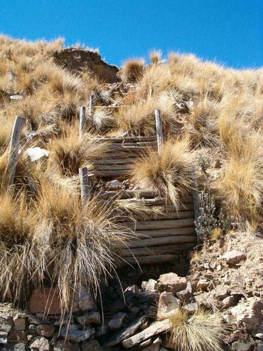
These practices are complemented by SWC measures throughout the catchment: biotrampas are staggered sediment traps located on the steep lateral slopes. They comprise ditches behind wooden barriers where soil accumulates. Biotrampas create suitable sites for tree/bush planting while stabilising the hillsides, reducing erosion, increasing infiltration and slowing siltation of the check dams in the watercourses. Supporting technologies include fenced-off areas for reforestation of the lateral slopes/upper edge of the gully, and finally large gabion dams at the outlets of the gullies, usually 10-25 m in length, but exceptionally up to 200 m.
After a few years vegetation should have stabilised the system, and effectively replaced the wooden and stone constructions. The various practices enhance each other. Establishment is labour demanding, but other costs are low, as long as the material in question is locally obtainable. Maintenance costs are also low. The technology was implemented over a period of six years, starting in 1996, through the Programa de Manejo Integral de Cuencas (PROMIC).
2.3 Fotos da tecnologia
Galeria de Mídias


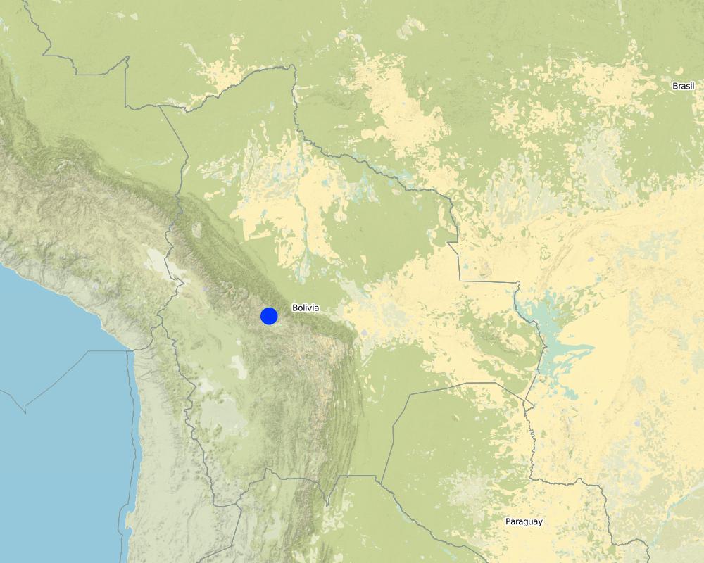
2.5 País/região/locais onde a tecnologia foi aplicada e que estão cobertos nesta avaliação
País:
Estado Plurinacional da Bolívia
Região/Estado/Província:
Cochabamba District,
Especificação adicional de localização:
Pajcha Watershed Cordillera del Tunari
Map
×2.7 Introdução da tecnologia
Especifique como a tecnologia foi introduzida:
- através de projetos/intervenções externas
3. Classificação da tecnologia de GST
3.1 Principal/principais finalidade(s) da tecnologia
- Reduz, previne, recupera a degradação do solo
3.2 Tipo(s) atualizado(s) de uso da terra onde a tecnologia foi aplicada

Terra de cultivo
- Cultura anual

Pastagem
Comentários:
Major land use problems (compiler’s opinion): Deforestation, overgrazing and poorly managed channel irrigation in areas with steep slopes: poorly structured soils and
extreme climatic variability causing erosion gullies, landslides, downstream flooding and sedimentation of agricultural land and settlements - including the city of Cochabamba.
Other grazingland: extensive grazing
3.3 Mais informações sobre o uso da terra
Abastecimento de água para a terra na qual a tecnologia é aplicada:
- Precipitação natural
Especifique:
Longest growing period in days: 210 Longest growing period from month to month: Oct - Apr
3.4 Grupo de GST ao qual pertence a tecnologia
- Medidas de curva de nível
- Desvio e drenagem de água
- Sediment traps
3.5 Difusão da tecnologia
Comentários:
Total area covered by the SLM Technology is 6 m2.
3.6 Medidas de GST contendo a tecnologia
3.7 Principais tipos de degradação da terra abordados pela tecnologia

Erosão do solo pela água
- Wg: Erosão por ravinas/ravinamento
- Wm: movimento de massas/deslizamentos
- Wo: efeitos de degradação externa

Degradação biológica
- Bq: quantidade/ declínio da biomassa
Comentários:
Main type of degradation addressed: Wg: gully erosion / gullying, Wm: mass movements / landslides, Wo: offsite degradation effects, Bq: quantity / biomass decline
3.8 Redução, prevenção ou recuperação da degradação do solo
Especifique o objetivo da tecnologia em relação a degradação da terra:
- Recuperar/reabilitar solo severamente degradado
4. Especificações técnicas, implementação de atividades, entradas e custos
4.1 Desenho técnico da tecnologia

Autor:
Mats Gurtner
4.2 Especificações técnicas/ explicações do desenho técnico
Gully control and catchment protection: an overview of the integrated measures.
Technical knowledge required for field staff / advisors: moderate
Technical knowledge required for land users: moderate
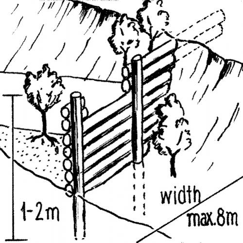
Main technical functions: reduction of slope angle, reduction of slope length, improvement of ground cover, increase in organic matter, sediment retention / trapping, sediment harvesting, control of concentrated runoff
Secondary technical functions: increase of infiltration, control of dispersed runoff
Vegetative measure: grassed bunds
Vegetative material: G : grass
Vegetative measure: aligned trees
Vegetative material: G : grass
Vegetative measure: Vegetative material: G : grass
Vegetative measure: Vegetative material: G : grass
Structural measure: cut-off drains
4.4 Atividades de implantação
| Atividade | Tipo de medida | Periodicidade | |
|---|---|---|---|
| 1. | Plant local bushes and trees in front and behind the biotrampas andthe check dams (after sedimentation). Altitude acclimatisation (2 weeks)is required for the trees before planting. | Vegetativo | |
| 2. | Cut-off drains: excavate channel above the gully. Lay stones in the bedand plant local bushes or grass on the bund below the ditch. The outletof the ditch into the gully is stabilised by a few stone steps. | Estrutural | |
| 3. | Stone check dams: excavate a ditch perpendicular to the water channel | Estrutural | during the dry season |
| 4. | Wooden check dams (up to 8 m long, 15–20 cm wide and 1 m high):soil excavation (see 2.). Fix logs with wire or nails to vertical poles.Position a bio-fibre fleece behind the dam to prevent sediment fromflowing through. | Estrutural | |
| 5. | Biotrampas: excavate soil, hammer wooden posts into the soil andfix 2–3 horizontal logs with nails or wire to the wooden posts. | Estrutural | (During dry season) |
| 6. | Plant local bushes and trees in front and behind the biotrampas andthe check dams (after sedimentation). Altitude acclimatisation (2 weeks)is required for the trees before planting. Establish fences to protect the plants. | Estrutural |
4.5 Custos e entradas necessárias para a implantação
| Especifique a entrada | Unidade | Quantidade | Custos por unidade | Custos totais por entrada | % dos custos arcados pelos usuários da terra | |
|---|---|---|---|---|---|---|
| Mão-de-obra | Labour | ha | 1,0 | 48,0 | 48,0 | |
| Equipamento | Tools | ha | 1,0 | 4,0 | 4,0 | |
| Material vegetal | Seedlings | ha | 1,0 | 19,0 | 19,0 | |
| Material de construção | Stone | ha | 1,0 | |||
| Material de construção | Wood | ha | 1,0 | 33,0 | 33,0 | |
| Material de construção | Nails, wire | ha | 1,0 | 2,0 | 2,0 | |
| Material de construção | Bio-fibre fleece | ha | 1,0 | 4,0 | 4,0 | |
| Custos totais para a implantação da tecnologia | 110,0 | |||||
4.6 Atividades recorrentes/manutenção
| Atividade | Tipo de medida | Periodicidade/frequência | |
|---|---|---|---|
| 1. | Biotrampas: pruning the trees | Vegetativo | /every three years. |
| 2. | Cut-off drains: clearing of sediment, cutting bushes and grasses. | Vegetativo | |
| 3. | Stone check dams: pruning trees and bushes. After full sedimentation, the dam may be increased in height. | Vegetativo | /every three years. |
| 4. | Wooden check dams: pruning trees and bushes | Vegetativo | /every three years |
4.7 Custos e entradas necessárias pata a manutenção/atividades recorrentes (por ano)
| Especifique a entrada | Unidade | Quantidade | Custos por unidade | Custos totais por entrada | % dos custos arcados pelos usuários da terra | |
|---|---|---|---|---|---|---|
| Mão-de-obra | Labour | ha | 1,0 | 12,0 | 12,0 | 100,0 |
| Equipamento | Tools | ha | 1,0 | 1,0 | 1,0 | 100,0 |
| Material vegetal | Seedlings | ha | 1,0 | 1,0 | 1,0 | 100,0 |
| Material de construção | Stone | ha | 1,0 | |||
| Material de construção | Wood | ha | 1,0 | 1,0 | 1,0 | 100,0 |
| Material de construção | Nails, wire | ha | 1,0 | 1,0 | 1,0 | 100,0 |
| Custos totais para a manutenção da tecnologia | 16,0 | |||||
Comentários:
Costs have been calculated for the whole catchment (6 km2) – including 100 m of cut-off drains, 6,750 m of stone
check dams, 1,500 m of wooden check dams and 770 biotrampas – and then divided by the number of hectares. Wood is not locally available (because of national park laws) and needs to be brought into the area. Establishment and maintenance costs were paid by PROMIC during their intervention period of 6 years. The (high) costs of the gabion weirs further downstream are not included as these are not always required and vary considerably in size from site to site.
5. Ambiente natural e humano
5.1 Clima
Precipitação pluviométrica anual
- <250 mm
- 251-500 mm
- 501-750 mm
- 751-1.000 mm
- 1.001-1.500 mm
- 1.501-2.000 mm
- 2.001-3.000 mm
- 3.001-4.000 mm
- > 4.000 mm
Zona agroclimática
- Subúmido
- Semiárido
5.2 Topografia
Declividade média:
- Plano (0-2%)
- Suave ondulado (3-5%)
- Ondulado (6-10%)
- Moderadamente ondulado (11-15%)
- Forte ondulado (16-30%)
- Montanhoso (31-60%)
- Escarpado (>60%)
Formas de relevo:
- Planalto/planície
- Cumes
- Encosta de serra
- Encosta de morro
- Sopés
- Fundos de vale
Zona de altitude:
- 0-100 m s.n.m.
- 101-500 m s.n.m.
- 501-1.000 m s.n.m.
- 1.001-1.500 m s.n.m.
- 1.501-2.000 m s.n.m.
- 2.001-2.500 m s.n.m.
- 2.501-3.000 m s.n.m.
- 3.001-4.000 m s.n.m.
- > 4.000 m s.n.m.
Comentários e outras especificações sobre a topografia:
Slopes on average: Also very steep and hilly (both ranked 2) and moderate and rolling (both ranked 3)
5.3 Solos
Profundidade do solo em média:
- Muito raso (0-20 cm)
- Raso (21-50 cm)
- Moderadamente profundo (51-80 cm)
- Profundo (81-120 cm)
- Muito profundo (>120 cm)
Textura do solo (solo superficial):
- Médio (limoso, siltoso)
Matéria orgânica do solo superficial:
- Alto (>3%)
- Baixo (<1%)
Caso disponível anexe a descrição completa do solo ou especifique as informações disponíveis, p. ex. tipo de solo, PH/acidez do solo, nitrogênio, capacidade de troca catiônica, salinidade, etc.
Soil depth on average: Also Very shallow (ranked 2) and shallow as well as deep (both ranked 3)
Soil fertility: Low and very low
Topsoil organic matter: High (on the cropland at high altitudes) and low (in the gullies)
Soil drainage/infiltration: Medium
5.6 Características dos usuários da terra que utilizam a tecnologia
Orientação de mercado do sistema de produção:
- Subsistência (autoabastecimento)
Rendimento não agrícola:
- 10-50% de toda renda
Indique outras características relevantes dos usuários da terra:
Market orientation: Subsistence (mostly subsistence (self-supply) with low market income)
5.7 Média da área de terra própria ou arrendada por usuários da terra que utilizam a tecnologia
- < 0,5 ha
- 0,5-1 ha
- 1-2 ha
- 2-5 ha
- 5-15 ha
- 15-50 ha
- 50-100 ha
- 100-500 ha
- 500-1.000 ha
- 1.000-10.000 ha
- > 10.000 ha
5.8 Propriedade de terra, direitos de uso da terra e de uso da água
Propriedade da terra:
- Indivíduo, intitulado
- communal grassland
Direitos do uso da terra:
- Comunitário (organizado)
- Indivíduo
6. Impactos e declarações finais
6.1 Impactos no local mostrados pela tecnologia
Impactos socioeconômicos
Produção
Produção agrícola
Comentários/especificar:
Maintained: Due to prevention of further land loss
Produção de forragens
Comentários/especificar:
Maintained: Due to prevention of further land loss
Renda e custos
Carga de trabalho
Comentários/especificar:
High labour input for establishment (though paid in this instance)
Impactos socioculturais
Instituições comunitárias
Conhecimento de GST/ degradação da terra
Impactos ecológicos
Solo
Umidade do solo
Cobertura do solo
Perda de solo
6.2 Impactos externos mostrados pela tecnologia
Cheias de jusante
Sedimentação a jusante
Benefit not for implementing farmers
Comentários/especificar:
farmers implementing SWC are not those benefiting most from the impact in the short term
6.4 Análise do custo-benefício
Como os benefícios se comparam aos custos de implantação (do ponto de vista dos usuários da terra)?
Retornos a curto prazo:
muito positivo
Retornos a longo prazo:
muito positivo
Como os benefícios se comparam aos custos recorrentes/de manutenção(do ponto de vista dos usuários da terra)?
Retornos a curto prazo:
muito positivo
Retornos a longo prazo:
muito positivo
6.5 Adoção da tecnologia
Entre todos aqueles que adotaram a tecnologia, quantos adotaram espontaneamente, ou seja, sem receber nenhum incentivo material/pagamentos?
- 0-10%
Comentários:
100% of land user families have adopted the Technology with external material support
There is no trend towards spontaneous adoption of the Technology
Comments on adoption trend: Only a few farmers have built new structures post-project. This is due to different reasons: (1) PROMIC stopped its financial support; (2) the gullied areas are not used by farmers, therefore they have little reason to protect them; (3) the catchment is w
6.7 Pontos fortes/vantagens/oportunidades da tecnologia
| Pontos fortes/vantagens/oportunidades na visão do/a compilador/a ou de outra pessoa capacitada |
|---|
|
Reduction of landslips and flooding in the valley How can they be sustained / enhanced? New small gullies may originate inside an existing gully or around it. It is important to continue to maintain the current measures and construct new, even though the subsidies of PROMIC have been terminated. |
|
The technology could be implemented by the farmers themselves as materials (except for wood) and tools are locally available How can they be sustained / enhanced? Prolong the sensitisation work to convince the farmers of the necessity and benefits of the technology. |
|
Reduction of soil loss in the watershed How can they be sustained / enhanced? Do not apply the mentioned practices in isolation but always in combination. |
| Simple technology with high positive long-term impact, especially downstream. |
6.8 Pontos fracos, desvantagens/riscos da tecnologia e formas de superá-los
| Pontos fracos/vantagens/riscos na visão do/a compilador/a ou de outra pessoa capacitada | Como eles podem ser superados? |
|---|---|
| The technology doesn’t address the root cause of human induced gully erosion | Alongside the gully control technology it is necessary to apply complementary conservation measures on the cropland above the gully to prevent new gully development. |
| High labour input for establishment of SWC measures. | An agreement on sustainable use of trees should be made with the national park authority. |
| The technology partly depends on inputs that are not available locally: timber for establishment of wooden structures (which is a significant quantity) are brought in from outside (since the area is within a national park tree felling is not allowed) |
7. Referências e links
7.2 Referências às publicações disponíveis
Título, autor, ano, ISBN:
Documentation of PROMIC (see address above)
Disponível de onde? Custos?
PROMIC, Programa de Manejo Integral
de Cuencas, Av. Atahuallpa final, Parque Tunari, casilla 4909, Cochabamba, Bolivia; promic@promic-bolivia.org; www.promic-bolivia.org
Links e módulos
Expandir tudo Recolher tudoLinks
Incentive-based catchment treatment [Estado Plurinacional da Bolívia]
A project supported, incentive-based approach: farmers are sensitised about erosion, and involved in gully control and other measures to protect catchments.
- Compilador/a: Unknown User
Módulos
Não há módulos