Gully control and catchment protection [Боливия, многонациональное государство]
- Создание:
- Обновить:
- Составитель: Georg Heim
- Редактор: –
- Рецензент: Fabian Ottiger
Control de cárcavas (spanish)
technologies_1350 - Боливия, многонациональное государство
Просмотреть разделы
Развернуть все Свернуть все1. Общая информация
1.2 Контактные данные специалистов и организаций, участвующих в описании и оценке Технологии
Специалист по УЗП:
Vargas Ivan
Cochabamba
Боливия, многонациональное государство
Название проекта, содействовавшего документированию/оценке Технологии (если применимо)
Book project: where the land is greener - Case Studies and Analysis of Soil and Water Conservation Initiatives Worldwide (where the land is greener)Название организации (-ий), содействовавших документированию/оценке Технологии (если применимо)
GEOTEST AG (GEOTEST AG) - Швейцария1.3 Условия, регламентирующие использование данных, собранных ВОКАТ
Когда были собраны данные (на местах)?
01/09/2003
Составитель и ответственный(-ые) специалист(-ы) согласны с условиями, регламентирующими использование собранных ВОКАТ данных:
Да
1.5 Ссылка на Анкету (-ы) по Подходам УЗП
Incentive-based catchment treatment [Боливия, многонациональное государство]
A project supported, incentive-based approach: farmers are sensitised about erosion, and involved in gully control and other measures to protect catchments.
- Составитель: Unknown User
2. Описание Технологии УЗП
2.1 Краткое описание Технологии
Определение Технологии:
Integrated gully treatment consisting of several simple practices including stone and wooden check dams, cut-off drains and reforestation in sediment traps (biotrampas).
2.2 Подробное описание Технологии
Описание:
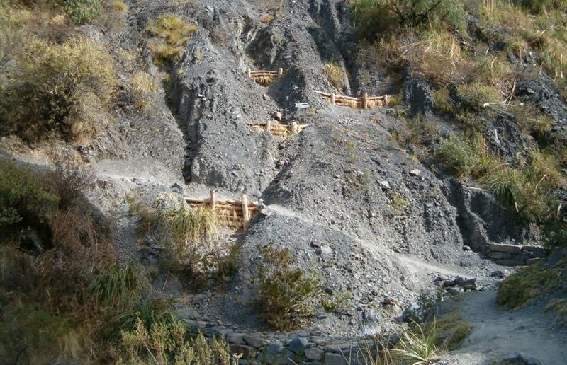
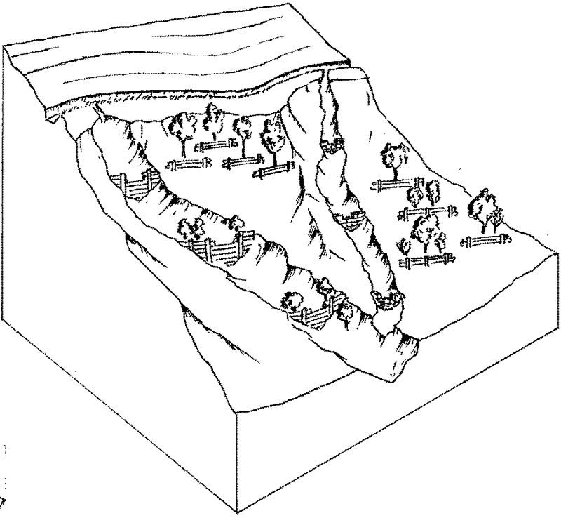
The focus of the case study is a degraded catchment, located at high altitude (2,800–4,200 m a.s.l.), home to 37 households, which is characterised by severe gullies and landslides. Gullies are continuously expanding, and constitute a significant proportion of the catchment. These cause considerable loss of cropland as well as downstream damage to the city of Cochabamba.
A combination of structural and vegetative measures was designed and implemented with the purpose of: (1) preventing affected areas from further degradation by safely discharging runoff from the surrounding area through the main gullies down to the valley; (2) gradually stabilising the land through the regeneration of vegetative cover; (3) reducing downstream damage through floods and siltation; (4) ensuring accessibility to the mountainous agricultural area during the rainy season.
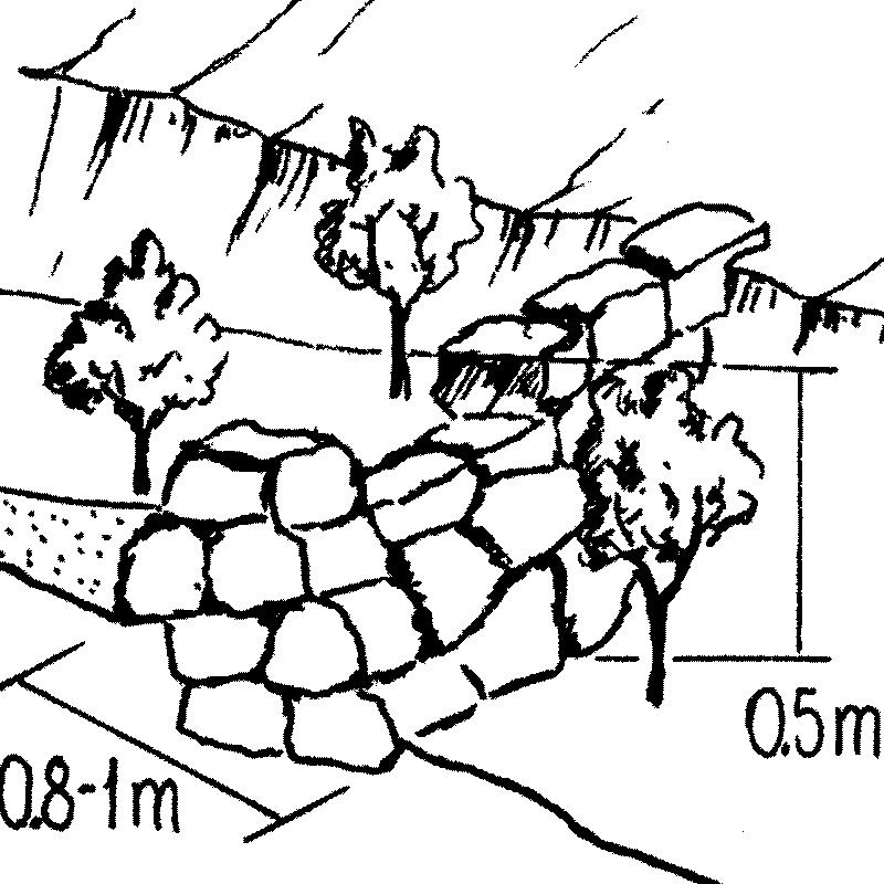
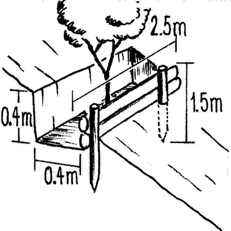
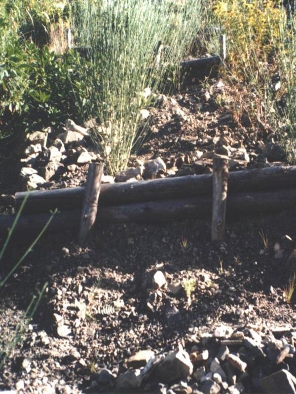
Cut-off drains at the heads of the gullies, reinforced with stones inside the channel and grassed bunds below, concentrate runoff and cascade it down over stone steps back into the waterways. Flow is controlled by stone and wooden check dams and discharged safely. Sediment is trapped behind these structures and terraces develop. Bushes or trees are planted above and below the check dams. Depending on availability of materials, wooden check dams are sometimes used and associated with tree planting (four trees above and four below each check dam).
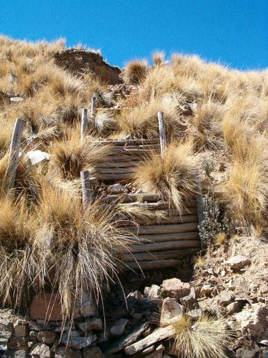
These practices are complemented by SWC measures throughout the catchment: biotrampas are staggered sediment traps located on the steep lateral slopes. They comprise ditches behind wooden barriers where soil accumulates. Biotrampas create suitable sites for tree/bush planting while stabilising the hillsides, reducing erosion, increasing infiltration and slowing siltation of the check dams in the watercourses. Supporting technologies include fenced-off areas for reforestation of the lateral slopes/upper edge of the gully, and finally large gabion dams at the outlets of the gullies, usually 10-25 m in length, but exceptionally up to 200 m.
After a few years vegetation should have stabilised the system, and effectively replaced the wooden and stone constructions. The various practices enhance each other. Establishment is labour demanding, but other costs are low, as long as the material in question is locally obtainable. Maintenance costs are also low. The technology was implemented over a period of six years, starting in 1996, through the Programa de Manejo Integral de Cuencas (PROMIC).
2.3 Фотографии, иллюстрирующие Технологию
Медиа-галерея


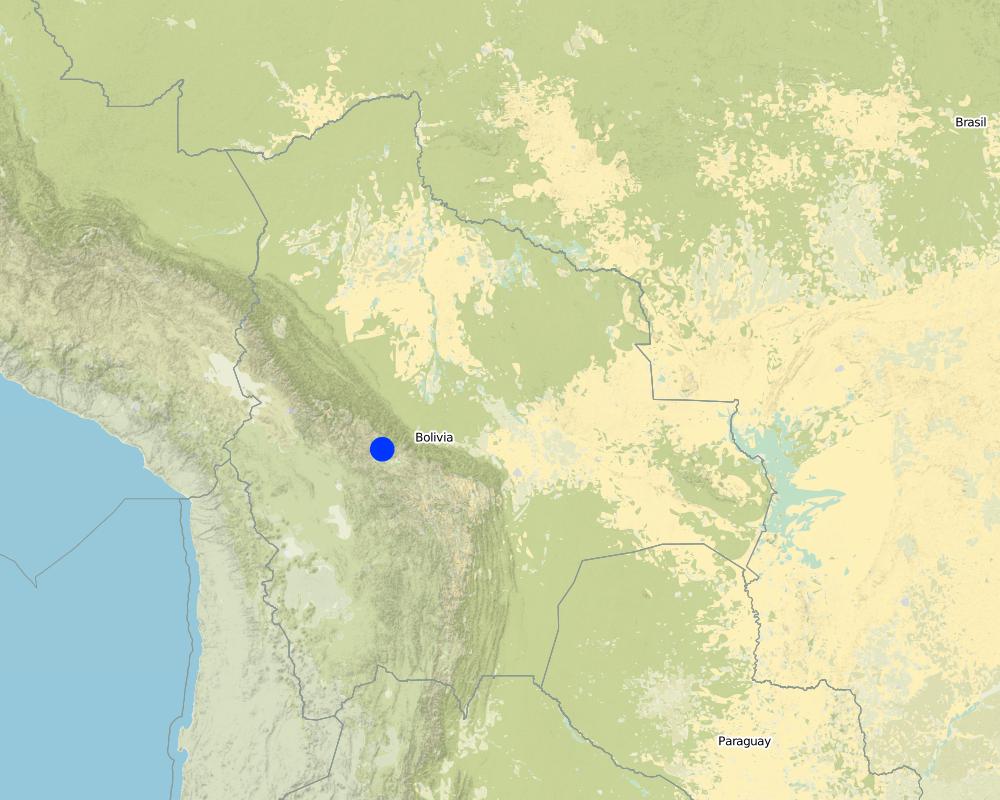
2.5 Страна/ регион/ места, где применяется Технология, информация о которых собрана в данной Анкете
Страна:
Боливия, многонациональное государство
Административная единица (Район/Область):
Cochabamba District,
Более точная привязка места:
Pajcha Watershed Cordillera del Tunari
Map
×2.7 Внедрение Технологии
Укажите, как именно Технология УЗП была внедрена:
- через проекты/ внешнее вмешательство
3. Классификация Технологии УЗП
3.1 Основные цели и задачи реализации Технологии
- снижение или предотвращение деградации земель, восстановление нарушенных земель
3.2 Текущий(-ие) тип(-ы) землепользования на территории, где применяется Технология

Пахотные угодья и плантации
- Однолетние культуры

Пастбищные угодья
Пояснения:
Major land use problems (compiler’s opinion): Deforestation, overgrazing and poorly managed channel irrigation in areas with steep slopes: poorly structured soils and
extreme climatic variability causing erosion gullies, landslides, downstream flooding and sedimentation of agricultural land and settlements - including the city of Cochabamba.
Other grazingland: extensive grazing
3.3 Дополнительная информация о землепользовании
Обеспеченность водой участков, где реализуется Технология :
- богарные земли
Поясните:
Longest growing period in days: 210 Longest growing period from month to month: Oct - Apr
3.4 Категория УЗП, к которой относится Технология
- мероприятия по влагозадержанию и снижению эрозии почв на склонах
- Водоотвод и осушение
- Sediment traps
3.5 Распределение Технологии по площади
Пояснения:
Total area covered by the SLM Technology is 6 m2.
3.6 Мероприятия УЗП, выполняемые в рамках Технологии
3.7 Основные проблемы деградации земель, на решение которых направлена Технология

водная эрозия почв
- ВЭл: овражная эрозия / оврагообразование
- ВЭо: гравитационное перемещение горных пород / оползни
- ВЭд: косвенное воздействие водной эрозии

биологическая деградация
- Бк: сокращение количества биомассы
Пояснения:
Main type of degradation addressed: Wg: gully erosion / gullying, Wm: mass movements / landslides, Wo: offsite degradation effects, Bq: quantity / biomass decline
3.8 Предотвращение и снижение деградации земель, или восстановление нарушенных земель
Укажите цель Технологии по отношению к деградации земель :
- восстановление/ реабилитация нарушенных земель
4. Технические характеристики, мероприятия по практической реализации, вложения и стоимость
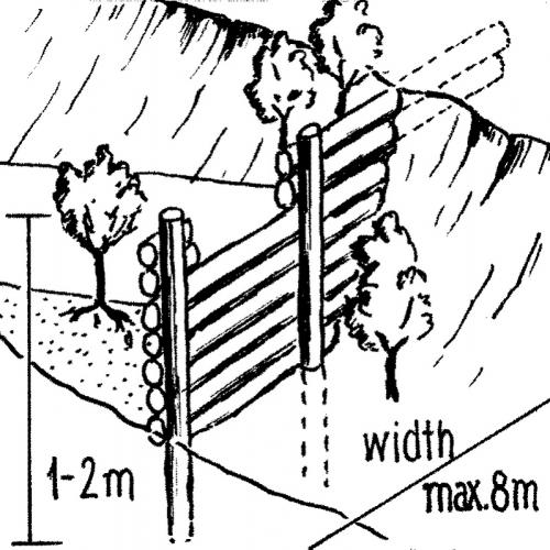
4.1 Технический рисунок, иллюстрирующий Технологию

Автор:
Mats Gurtner
4.2 Спецификация / пояснения к техническому рисунку
Gully control and catchment protection: an overview of the integrated measures.
Technical knowledge required for field staff / advisors: moderate
Technical knowledge required for land users: moderate
Main technical functions: reduction of slope angle, reduction of slope length, improvement of ground cover, increase in organic matter, sediment retention / trapping, sediment harvesting, control of concentrated runoff
Secondary technical functions: increase of infiltration, control of dispersed runoff
Vegetative measure: grassed bunds
Vegetative material: G : grass
Vegetative measure: aligned trees
Vegetative material: G : grass
Vegetative measure: Vegetative material: G : grass
Vegetative measure: Vegetative material: G : grass
Structural measure: cut-off drains
4.4 Мероприятия, необходимые для начала реализации
| Деятельность | Тип мероприятия | Сроки | |
|---|---|---|---|
| 1. | Plant local bushes and trees in front and behind the biotrampas andthe check dams (after sedimentation). Altitude acclimatisation (2 weeks)is required for the trees before planting. | Мероприятия с использованием растительности | |
| 2. | Cut-off drains: excavate channel above the gully. Lay stones in the bedand plant local bushes or grass on the bund below the ditch. The outletof the ditch into the gully is stabilised by a few stone steps. | Инженерные | |
| 3. | Stone check dams: excavate a ditch perpendicular to the water channel | Инженерные | during the dry season |
| 4. | Wooden check dams (up to 8 m long, 15–20 cm wide and 1 m high):soil excavation (see 2.). Fix logs with wire or nails to vertical poles.Position a bio-fibre fleece behind the dam to prevent sediment fromflowing through. | Инженерные | |
| 5. | Biotrampas: excavate soil, hammer wooden posts into the soil andfix 2–3 horizontal logs with nails or wire to the wooden posts. | Инженерные | (During dry season) |
| 6. | Plant local bushes and trees in front and behind the biotrampas andthe check dams (after sedimentation). Altitude acclimatisation (2 weeks)is required for the trees before planting. Establish fences to protect the plants. | Инженерные |
4.5 Вложения и затраты, необходимые для начала реализации
| Опишите затраты | Единица | Количество | Затраты на единицу | Общая стоимость на единицу | % затрат, оплаченных землепользователями | |
|---|---|---|---|---|---|---|
| Оплата труда | Labour | ha | 1,0 | 48,0 | 48,0 | |
| Оборудование | Tools | ha | 1,0 | 4,0 | 4,0 | |
| Посадочный материал | Seedlings | ha | 1,0 | 19,0 | 19,0 | |
| Строительные материалы | Stone | ha | 1,0 | |||
| Строительные материалы | Wood | ha | 1,0 | 33,0 | 33,0 | |
| Строительные материалы | Nails, wire | ha | 1,0 | 2,0 | 2,0 | |
| Строительные материалы | Bio-fibre fleece | ha | 1,0 | 4,0 | 4,0 | |
| Общая стоимость запуска Технологии | 110,0 | |||||
4.6 Поддержание/ текущее обслуживание
| Деятельность | Тип мероприятия | Сроки/ повторяемость проведения | |
|---|---|---|---|
| 1. | Biotrampas: pruning the trees | Мероприятия с использованием растительности | /every three years. |
| 2. | Cut-off drains: clearing of sediment, cutting bushes and grasses. | Мероприятия с использованием растительности | |
| 3. | Stone check dams: pruning trees and bushes. After full sedimentation, the dam may be increased in height. | Мероприятия с использованием растительности | /every three years. |
| 4. | Wooden check dams: pruning trees and bushes | Мероприятия с использованием растительности | /every three years |
4.7 Стоимость поддержания/ текущего обслуживания ( в год)
| Опишите затраты | Единица | Количество | Затраты на единицу | Общая стоимость на единицу | % затрат, оплаченных землепользователями | |
|---|---|---|---|---|---|---|
| Оплата труда | Labour | ha | 1,0 | 12,0 | 12,0 | 100,0 |
| Оборудование | Tools | ha | 1,0 | 1,0 | 1,0 | 100,0 |
| Посадочный материал | Seedlings | ha | 1,0 | 1,0 | 1,0 | 100,0 |
| Строительные материалы | Stone | ha | 1,0 | |||
| Строительные материалы | Wood | ha | 1,0 | 1,0 | 1,0 | 100,0 |
| Строительные материалы | Nails, wire | ha | 1,0 | 1,0 | 1,0 | 100,0 |
| Общая стоимость поддержания Технологии | 16,0 | |||||
Пояснения:
Costs have been calculated for the whole catchment (6 km2) – including 100 m of cut-off drains, 6,750 m of stone
check dams, 1,500 m of wooden check dams and 770 biotrampas – and then divided by the number of hectares. Wood is not locally available (because of national park laws) and needs to be brought into the area. Establishment and maintenance costs were paid by PROMIC during their intervention period of 6 years. The (high) costs of the gabion weirs further downstream are not included as these are not always required and vary considerably in size from site to site.
5. Природные и социально-экономические условия
5.1 Климат
Среднегодовое количество осадков
- < 250 мм
- 251-500 мм
- 501-750 мм
- 751-1000 мм
- 1001-1500 мм
- 1501-2000 мм
- 2001-3000 мм
- 3001-4000 мм
- > 4000 мм
Агроклиматическая зона
- Умеренно-влажная
- полузасушливая
5.2 Рельеф
Склоны (преобладающие):
- пологие (0-2%)
- покатые (3-5%)
- покато-крутые (6-10%)
- крутые (11-15%)
- очень крутые (16-30%)
- чрезвычайно крутые (31-60%)
- обрывистые (>60%)
Формы рельефа:
- плато/ равнины
- гребни хребтов/холмов
- склоны гор
- склоны холмов
- подножья
- днища долин
Зона высотной поясности:
- 0-100 м над уровнем моря
- 101-500 м н.у.м.
- 501-1000 м н.у.м.
- 1001-1500 м н.у.м.
- 1501-2000 м н.у.м.
- 2001-2500 м н.у.м.
- 2501-3000 м н.у.м.
- 3001-4000 м н.у.м.
- > 4 тыс. м н.у.м.
Комментарии и дополнительные сведения по условиям рельефа/ топографии :
Slopes on average: Also very steep and hilly (both ranked 2) and moderate and rolling (both ranked 3)
5.3 Почвы
Средняя мощность почв:
- поверхностные (0-20 см)
- неглубокие (21-50 см)
- умеренно глубокие (51-80 см)
- глубокие (81-120 см)
- очень глубокие (> 120 см)
Гранулометрический состав (верхнего горизонта):
- средние фракции (суглинистый, супесчаный)
Содержание органического вещества в верхнем горизонте:
- высокое (> 3%)
- низкое (< 1%)
Если возможно, приложите полное описание почв или укажите доступную информацию, например тип почв, рH/ кислотность почв, ёмкость катионного обмена, содержание азота, содержание солей и т.д.
Soil depth on average: Also Very shallow (ranked 2) and shallow as well as deep (both ranked 3)
Soil fertility: Low and very low
Topsoil organic matter: High (on the cropland at high altitudes) and low (in the gullies)
Soil drainage/infiltration: Medium
5.6 Характеристика землепользователей, применяющих Технологию
Рыночная ориентация производства:
- натуральное хозяйство (самообеспечение)
Доходы из других источников:
- 10-50% всех доходов
Укажите другие важные характеристики землепользователей:
Market orientation: Subsistence (mostly subsistence (self-supply) with low market income)
5.7 Средний размер земельных участков, арендуемых или находящихся в собственности землепользователей, применяющих Технологию
- < 0,5 га
- 0,5-1 га
- 1-2 га
- 2-5 га
- 5-15 га
- 15-50 га
- 50-100 га
- 100-500 га
- 500-1000 га
- 1000-10000 га
- > 10000 га
5.8 Собственность на землю, права на земле- и водопользование
Землевладелец:
- индивидуальная, оформленная в собственность
- communal grassland
Право землепользования:
- общинное (контролируемое)
- индивидуальное
6. Воздействия и заключительные положения
6.1 Влияние Технологии УЗП в пределах территории ее применения
Социально-экономическое воздействие
Продуктивность
производство сельскозяйственных культур
Комментарий/ пояснения:
Maintained: Due to prevention of further land loss
производство кормов
Комментарий/ пояснения:
Maintained: Due to prevention of further land loss
Доходы и затраты
объем работ
Комментарий/ пояснения:
High labour input for establishment (though paid in this instance)
Социальное и культурное воздействие
местное самоуправление
знания в области УЗП/ деградации земель
Экологическое воздействие
Почвы
влажность почв
почвенный покров
утрата почв
6.2 Влияние Технологии за пределами территории ее применения
подтопление ниже по течению
отложение наносов ниже по течению
Benefit not for implementing farmers
Комментарий/ пояснения:
farmers implementing SWC are not those benefiting most from the impact in the short term
6.4 Анализ эффективности затрат
Насколько получаемый результат сопоставим с первоначальными вложениями (с точки зрения землепользователей)?
Эффективность затрат в краткосрочной перспективе:
очень позитивное
Эффективность затрат в долгосрочной перспективе:
очень позитивное
Насколько получаемый результат сопоставим с текущими расходами по поддержанию технологии (с точки зрения землепользователей)?
Эффективность затрат в краткосрочной перспективе:
очень позитивное
Эффективность затрат в долгосрочной перспективе:
очень позитивное
6.5 Внедрение Технологии
Среди применяющих Технологию землепользователей, какова доля лиц, применяющих её по собственной инициативе, т.е. без какого-либо материального стимулирования со стороны?
- 0-10%
Пояснения:
100% of land user families have adopted the Technology with external material support
There is no trend towards spontaneous adoption of the Technology
Comments on adoption trend: Only a few farmers have built new structures post-project. This is due to different reasons: (1) PROMIC stopped its financial support; (2) the gullied areas are not used by farmers, therefore they have little reason to protect them; (3) the catchment is w
6.7 Сильные стороны/ преимущества/ возможности Технологии
| Сильные стороны/ преимущества/ возможности по мнению составителя или других ключевых специалистов |
|---|
|
Reduction of landslips and flooding in the valley How can they be sustained / enhanced? New small gullies may originate inside an existing gully or around it. It is important to continue to maintain the current measures and construct new, even though the subsidies of PROMIC have been terminated. |
|
The technology could be implemented by the farmers themselves as materials (except for wood) and tools are locally available How can they be sustained / enhanced? Prolong the sensitisation work to convince the farmers of the necessity and benefits of the technology. |
|
Reduction of soil loss in the watershed How can they be sustained / enhanced? Do not apply the mentioned practices in isolation but always in combination. |
| Simple technology with high positive long-term impact, especially downstream. |
6.8 Слабые стороны/ недостатки/ риски Технологии и пути их преодоления
| Слабые стороны/ недостатки/ риски по мнению составителя или ответственных специалистов | Возможные пути их преодоления/снижения? |
|---|---|
| The technology doesn’t address the root cause of human induced gully erosion | Alongside the gully control technology it is necessary to apply complementary conservation measures on the cropland above the gully to prevent new gully development. |
| High labour input for establishment of SWC measures. | An agreement on sustainable use of trees should be made with the national park authority. |
| The technology partly depends on inputs that are not available locally: timber for establishment of wooden structures (which is a significant quantity) are brought in from outside (since the area is within a national park tree felling is not allowed) |
7. Справочные материалы и ссылки
7.2 Ссылки на опубликованные материалы
Название, автор, год публикации, ISBN:
Documentation of PROMIC (see address above)
Где опубликовано? Стоимость?
PROMIC, Programa de Manejo Integral
de Cuencas, Av. Atahuallpa final, Parque Tunari, casilla 4909, Cochabamba, Bolivia; promic@promic-bolivia.org; www.promic-bolivia.org
Ссылки и модули
Развернуть все Свернуть всеСсылки
Incentive-based catchment treatment [Боливия, многонациональное государство]
A project supported, incentive-based approach: farmers are sensitised about erosion, and involved in gully control and other measures to protect catchments.
- Составитель: Unknown User
Модули
Нет модулей