Gully control and catchment protection [ບໍລີເວຍ, ລັດພູລິເນຊັນນໍ]
- ການສ້າງ:
- ປັບປູງ:
- ຜູ້ສັງລວມຂໍ້ມູນ: Georg Heim
- ບັນນາທິການ: –
- ຜູ້ທົບທວນຄືນ: Fabian Ottiger
Control de cárcavas (spanish)
technologies_1350 - ບໍລີເວຍ, ລັດພູລິເນຊັນນໍ
ເບິ່ງພາກສ່ວນ
ຂະຫຍາຍທັງໝົດ ຍຸບທັງໝົດ1. ຂໍ້ມູນທົ່ວໄປ
1.2 ຂໍ້ມູນ ການຕິດຕໍ່ພົວພັນ ຂອງບຸກຄົນທີ່ສໍາຄັນ ແລະ ສະຖາບັນ ທີ່ມີສ່ວນຮ່ວມ ໃນການປະເມີນເອກກະສານ ເຕັກໂນໂລຢີ
ຜຸ້ຊ່ຽວຊານ ດ້ານການຄຸ້ມຄອງ ທີ່ດິນແບບຍືນຍົງ:
Vargas Ivan
Cochabamba
ບໍລີເວຍ, ລັດພູລິເນຊັນນໍ
ຊື່ໂຄງການ ທີ່ອໍານວຍຄວາມສະດວກ ໃນການສ້າງເອກກະສານ/ປະເມີນ ເຕັກໂນໂລຢີ (ຖ້າກ່ຽວຂ້ອງ)
Book project: where the land is greener - Case Studies and Analysis of Soil and Water Conservation Initiatives Worldwide (where the land is greener)ຊື່ສະຖາບັນ (ຫຼາຍສະຖາບັນ) ທີ່ອໍານວຍຄວາມສະດວກ ໃນການສ້າງເອກກະສານ / ປະເມີນ ເຕັກໂນໂລຢີ (ຖ້າກ່ຽວຂ້ອງ)
GEOTEST AG (GEOTEST AG) - ສະວິດເຊີແລນ1.3 ເງື່ອນໄຂ ກ່ຽວກັບ ການນໍາໃຊ້ຂໍ້ມູນເອກະສານ ທີ່ສ້າງຂື້ນ ໂດຍຜ່ານ ອົງການພາບລວມຂອງໂລກ ທາງດ້ານແນວທາງ ແລະ ເຕັກໂນໂລຢີ ຂອງການອານຸລັກ ທໍາມະຊາດ (WOCAT)
ເມື່ອໃດທີ່ໄດ້ສັງລວມຂໍ້ມູນ (ຢູ່ພາກສະໜາມ)?
01/09/2003
ຜູ້ປ້ອນຂໍ້ມູນ ແລະ ບຸກຄົນສຳຄັນ ທີ່ໃຫ້ຂໍ້ມູນ (ຫຼາຍ) ຍິນຍອມ ຕາມເງື່ອນໄຂ ໃນການນຳໃຊ້ຂໍ້ມູນ ເພື່ອສ້າງເປັນເອກກະສານຂອງ WOCAT:
ແມ່ນ
1.5 ອ້າງອີງເຖິງແບບສອບສອບຖາມ (ຫຼາຍ) ທາງດ້ານວິທີການ ໃນການຄຸ້ມຄອງ ທີ່ດິນແບບຍືນຍົງ
Incentive-based catchment treatment [ບໍລີເວຍ, ລັດພູລິເນຊັນນໍ]
A project supported, incentive-based approach: farmers are sensitised about erosion, and involved in gully control and other measures to protect catchments.
- ຜູ້ສັງລວມຂໍ້ມູນ: Unknown User
2. ການອະທິບາຍ ເຕັກໂນໂລຢີ ຂອງການຄຸ້ມຄອງ ທີ່ດິນແບບຍືນຍົງ
2.1 ຄໍາອະທິບາຍສັ້ນຂອງ ເຕັກໂນໂລຢີ
ການກຳໜົດຄວາມໝາຍ ຂອງເຕັກໂນໂລຢີ:
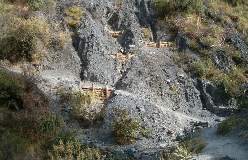
Integrated gully treatment consisting of several simple practices including stone and wooden check dams, cut-off drains and reforestation in sediment traps (biotrampas).
2.2 ການອະທິບາຍ ລາຍລະອຽດ ຂອງເຕັກໂນໂລຢີ
ການພັນລະນາ:
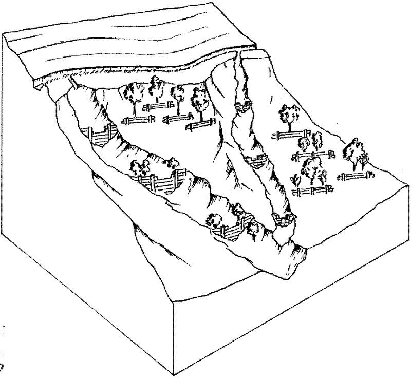
The focus of the case study is a degraded catchment, located at high altitude (2,800–4,200 m a.s.l.), home to 37 households, which is characterised by severe gullies and landslides. Gullies are continuously expanding, and constitute a significant proportion of the catchment. These cause considerable loss of cropland as well as downstream damage to the city of Cochabamba.
A combination of structural and vegetative measures was designed and implemented with the purpose of: (1) preventing affected areas from further degradation by safely discharging runoff from the surrounding area through the main gullies down to the valley; (2) gradually stabilising the land through the regeneration of vegetative cover; (3) reducing downstream damage through floods and siltation; (4) ensuring accessibility to the mountainous agricultural area during the rainy season.
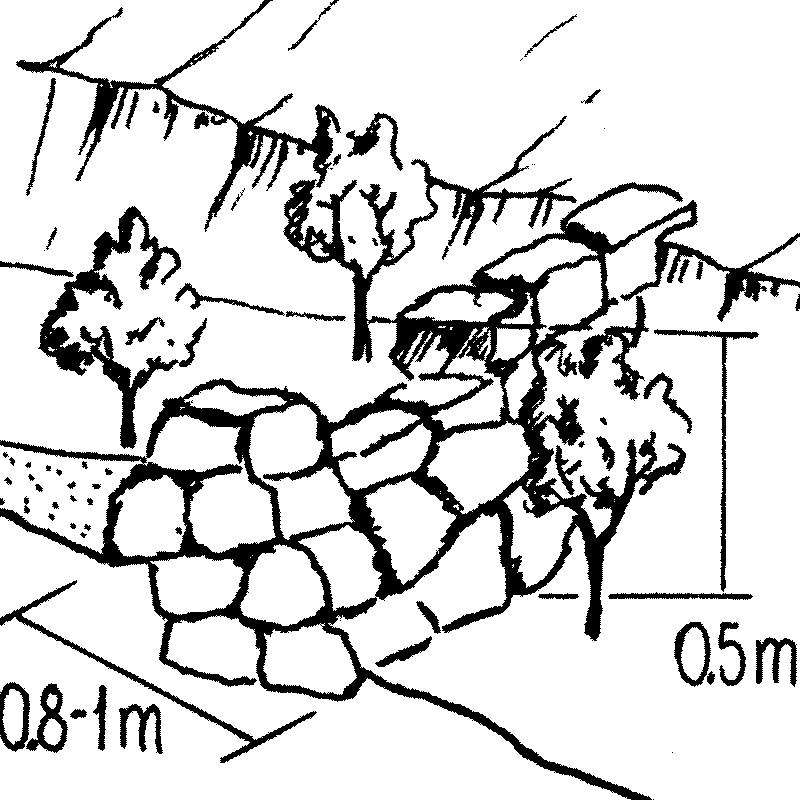
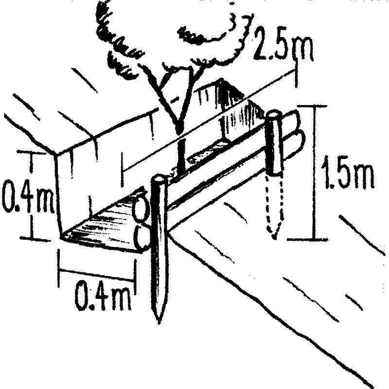
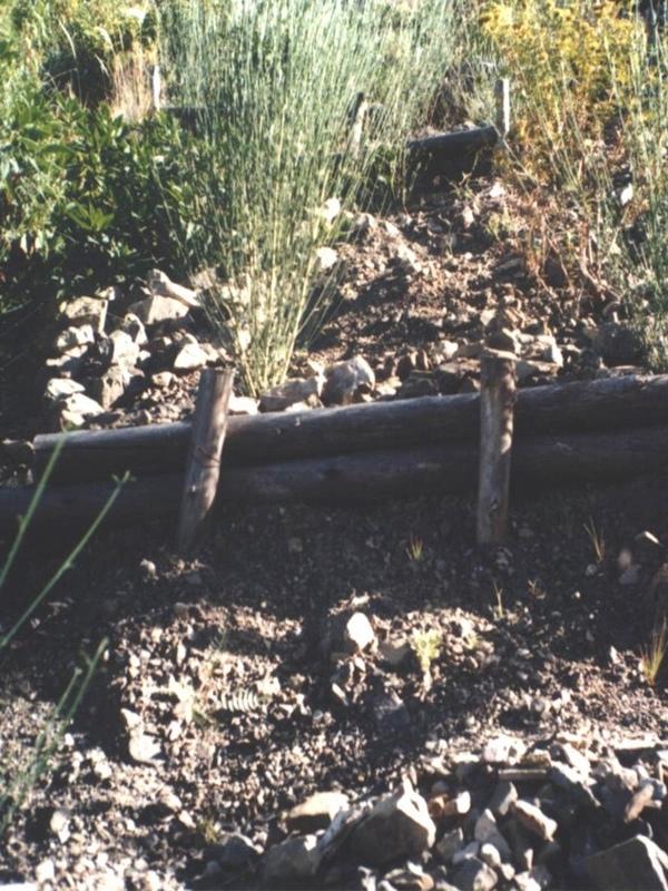
Cut-off drains at the heads of the gullies, reinforced with stones inside the channel and grassed bunds below, concentrate runoff and cascade it down over stone steps back into the waterways. Flow is controlled by stone and wooden check dams and discharged safely. Sediment is trapped behind these structures and terraces develop. Bushes or trees are planted above and below the check dams. Depending on availability of materials, wooden check dams are sometimes used and associated with tree planting (four trees above and four below each check dam).
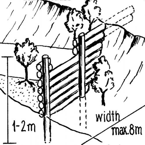
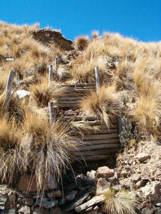
These practices are complemented by SWC measures throughout the catchment: biotrampas are staggered sediment traps located on the steep lateral slopes. They comprise ditches behind wooden barriers where soil accumulates. Biotrampas create suitable sites for tree/bush planting while stabilising the hillsides, reducing erosion, increasing infiltration and slowing siltation of the check dams in the watercourses. Supporting technologies include fenced-off areas for reforestation of the lateral slopes/upper edge of the gully, and finally large gabion dams at the outlets of the gullies, usually 10-25 m in length, but exceptionally up to 200 m.
After a few years vegetation should have stabilised the system, and effectively replaced the wooden and stone constructions. The various practices enhance each other. Establishment is labour demanding, but other costs are low, as long as the material in question is locally obtainable. Maintenance costs are also low. The technology was implemented over a period of six years, starting in 1996, through the Programa de Manejo Integral de Cuencas (PROMIC).
2.3 ຮູບພາບຂອງເຕັກໂນໂລຢີ
ສື່ຮູບພາບ


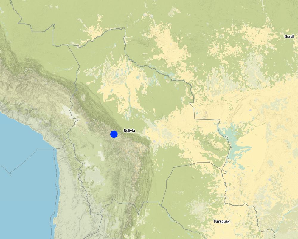
2.5 ປະເທດ / ເຂດ / ສະຖານທີ່ບ່ອນທີ່ ເຕັກໂນໂລຢີ ໄດ້ຮັບການນໍາໃຊ້ ແລະ ທີ່ຖືກປົກຄຸມດ້ວຍການປະເມີນຜົນ
ປະເທດ:
ບໍລີເວຍ, ລັດພູລິເນຊັນນໍ
ພາກພື້ນ / ລັດ / ແຂວງ:
Cochabamba District,
ຂໍ້ມູນເພີ່ມເຕີມຂອງສະຖານທີ່:
Pajcha Watershed Cordillera del Tunari
Map
×2.7 ການນໍາສະເໜີ ເຕັກໂນໂລຢີ
ໃຫ້ລະບຸ ເຕັກໂນໂລຢີ ໄດ້ຖືກຈັດຕັ້ງປະຕິບັດຄືແນວໃດ?
- ໂດຍຜ່ານໂຄງການ / ການຊ່ວຍເຫຼືອຈາກພາຍນອກ
3. ການໃຈ້ແຍກ ເຕັກໂນໂລຢີ ໃນການຄຸ້ມຄອງ ດິນແບບຍືນຍົງ
3.1 ຈຸດປະສົງຫຼັກ (ຫຼາຍ) ຂອງເຕັກໂນໂລຢີ
- ຫຼຸດຜ່ອນ, ປ້ອງກັນ, ຟື້ນຟູ ການເຊື່ອມໂຊມຂອງດິນ
3.2 ປະເພດການນໍາໃຊ້ທີ່ດິນ ໃນປະຈຸບັນ() ທີ່ເຕັກໂນໂລຢີ ໄດ້ຖືກນໍາໃຊ້

ດິນທີ່ປູກພືດ
- ການປູກພືດປະຈໍາປີ

ທົ່ງຫຍ້າລ້ຽງສັດ
ຄວາມຄິດເຫັນ:
Major land use problems (compiler’s opinion): Deforestation, overgrazing and poorly managed channel irrigation in areas with steep slopes: poorly structured soils and
extreme climatic variability causing erosion gullies, landslides, downstream flooding and sedimentation of agricultural land and settlements - including the city of Cochabamba.
Other grazingland: extensive grazing
3.3 ຂໍ້ມູນເພີ່ມເຕີມກ່ຽວກັບການນໍາໃຊ້ທີ່ດິນ
ການສະໜອງນໍ້າ ໃນພື້ນທີ່ ທີ່ໄດ້ນໍາໃຊ້ ເຕັກໂນໂລຢີ:
- ນໍ້າຝົນ
ລະບຸ ຊະນິດ:
Longest growing period in days: 210 Longest growing period from month to month: Oct - Apr
3.4 ການນໍາໃຊ້ເຕັກໂນໂລຢີ ທີ່ຢູ່ໃນກຸ່ມການຄຸ້ມຄອງ ທີ່ດິນແບບຍືນຍົງ
- ມາດຕະການ ຕັດຂວາງ ກັບຄວາມຄ້ອຍຊັນ
- ຄວາມຫຼາກຫຼາຍຂອງນໍ້າ ແລະ ການລະບາຍ
- Sediment traps
3.5 ການຂະຫຍາຍເຕັກໂນໂລຢີ
ຄວາມຄິດເຫັນ:
Total area covered by the SLM Technology is 6 m2.
3.6 ມາດຕະການ ການຄຸ້ມຄອງ ທີ່ດິນແບບຍືນຍົງ ປະກອບດ້ວຍ ເຕັກໂນໂລຢີ
3.7 ປະເພດດິນເຊື່ອມໂຊມ ຫຼັກທີ່ໄດ້ນໍາໃຊ້ ເຕັກໂນໂລຢີ

ດິນເຊາະເຈື່ອນ ໂດຍນໍ້າ
- Wg: ການເຊາະເຈື່ອນຮ່ອງນ້ຳ / ຫ້ວຍ
- Wm: ການເຄື່ອນຍ້າຍອິນຊີວັດຖຸ / ດິນເຈື່ອນ
- Wo: ຜົນກະທົບ ຂອງການເຊື່ອມໂຊມ ຕໍ່ພື້ນທີ່ພາຍນອກ

ການເຊື່ອມໂຊມ ທາງຊີວະພາບ
- Bq: ປະລິມານ / ອິນຊີວັດຖຸຫຼຸດລົງ
ຄວາມຄິດເຫັນ:
Main type of degradation addressed: Wg: gully erosion / gullying, Wm: mass movements / landslides, Wo: offsite degradation effects, Bq: quantity / biomass decline
3.8 ການປ້ອງກັນ, ການຫຼຸດຜ່ອນ, ຫຼືການຟື້ນຟູຂອງການເຊື່ອມໂຊມຂອງດິນ
ໃຫ້ລະບຸ ເປົ້າໝາຍ ເຕັກໂນໂລຢີ ທີ່ພົວພັນ ກັບຄວາມເຊື່ອມໂຊມຂອງດິນ:
- ການຟື້ນຟູ / ຟື້ນຟູດິນທີ່ຊຸດໂຊມ
4. ຂໍ້ກໍາໜົດ, ກິດຈະກໍາການປະຕິບັດ, ວັດຖຸດິບ, ແລະຄ່າໃຊ້ຈ່າຍ
4.1 ເຕັກນິກ ໃນການແຕ້ມແຜນວາດ ເຕັກໂນໂລຢີ

ຜູ້ຂຽນ:
Mats Gurtner
4.2 ການແຕ້ມແຜນວາດອະທິບາຍເຕັກນິກ
Gully control and catchment protection: an overview of the integrated measures.
Technical knowledge required for field staff / advisors: moderate
Technical knowledge required for land users: moderate
Main technical functions: reduction of slope angle, reduction of slope length, improvement of ground cover, increase in organic matter, sediment retention / trapping, sediment harvesting, control of concentrated runoff
Secondary technical functions: increase of infiltration, control of dispersed runoff
Vegetative measure: grassed bunds
Vegetative material: G : grass
Vegetative measure: aligned trees
Vegetative material: G : grass
Vegetative measure: Vegetative material: G : grass
Vegetative measure: Vegetative material: G : grass
Structural measure: cut-off drains
4.4 ການສ້າງຕັ້ງກິດຈະກໍາ
| ກິດຈະກໍາ | ປະເພດ ມາດຕະການ | ໄລຍະເວລາ | |
|---|---|---|---|
| 1. | Plant local bushes and trees in front and behind the biotrampas andthe check dams (after sedimentation). Altitude acclimatisation (2 weeks)is required for the trees before planting. | ການບໍາລຸງລ້ຽງ | |
| 2. | Cut-off drains: excavate channel above the gully. Lay stones in the bedand plant local bushes or grass on the bund below the ditch. The outletof the ditch into the gully is stabilised by a few stone steps. | ໂຄງສ້າງ | |
| 3. | Stone check dams: excavate a ditch perpendicular to the water channel | ໂຄງສ້າງ | during the dry season |
| 4. | Wooden check dams (up to 8 m long, 15–20 cm wide and 1 m high):soil excavation (see 2.). Fix logs with wire or nails to vertical poles.Position a bio-fibre fleece behind the dam to prevent sediment fromflowing through. | ໂຄງສ້າງ | |
| 5. | Biotrampas: excavate soil, hammer wooden posts into the soil andfix 2–3 horizontal logs with nails or wire to the wooden posts. | ໂຄງສ້າງ | (During dry season) |
| 6. | Plant local bushes and trees in front and behind the biotrampas andthe check dams (after sedimentation). Altitude acclimatisation (2 weeks)is required for the trees before planting. Establish fences to protect the plants. | ໂຄງສ້າງ |
4.5 ຕົ້ນທຶນ ແລະ ປັດໄຈຂາເຂົ້າທີ່ຈໍາເປັນໃນຈັດຕັ້ງປະຕິບັດ
| ລະບຸ ປັດໃຈ ນໍາເຂົ້າ ໃນການຜະລີດ | ຫົວໜ່ວຍ | ປະລິມານ | ຕົ້ນທຶນ ຕໍ່ຫົວໜ່ວຍ | ຕົ້ນທຶນທັງໝົດ ຂອງປັດໃຈຂາເຂົ້າ ໃນການຜະລິດ | % ຂອງຕົ້ນທຶນທັງໝົດ ທີ່ຜູ້ນໍາໃຊ້ທີ່ດິນ ໃຊ້ຈ່າຍເອງ | |
|---|---|---|---|---|---|---|
| ແຮງງານ | Labour | ha | 1.0 | 48.0 | 48.0 | |
| ອຸປະກອນ | Tools | ha | 1.0 | 4.0 | 4.0 | |
| ວັດສະດຸໃນການປູກ | Seedlings | ha | 1.0 | 19.0 | 19.0 | |
| ວັດສະດຸກໍ່ສ້າງ | Stone | ha | 1.0 | |||
| ວັດສະດຸກໍ່ສ້າງ | Wood | ha | 1.0 | 33.0 | 33.0 | |
| ວັດສະດຸກໍ່ສ້າງ | Nails, wire | ha | 1.0 | 2.0 | 2.0 | |
| ວັດສະດຸກໍ່ສ້າງ | Bio-fibre fleece | ha | 1.0 | 4.0 | 4.0 | |
| ຕົ້ນທຶນທັງໝົດ ໃນການຈັດຕັ້ງປະຕິບັດ ເຕັກໂນໂລຢີ | 110.0 | |||||
4.6 ບໍາລຸງຮັກສາ / ແຜນຈັດຕັ້ງປະຕິບັດ ກິດຈະກໍາ
| ກິດຈະກໍາ | ປະເພດ ມາດຕະການ | ໄລຍະເວລາ / ຄວາມຖີ່ | |
|---|---|---|---|
| 1. | Biotrampas: pruning the trees | ການບໍາລຸງລ້ຽງ | /every three years. |
| 2. | Cut-off drains: clearing of sediment, cutting bushes and grasses. | ການບໍາລຸງລ້ຽງ | |
| 3. | Stone check dams: pruning trees and bushes. After full sedimentation, the dam may be increased in height. | ການບໍາລຸງລ້ຽງ | /every three years. |
| 4. | Wooden check dams: pruning trees and bushes | ການບໍາລຸງລ້ຽງ | /every three years |
4.7 ຄ່າໃຊ້ຈ່າຍ ແລະ ປັດໄຈນໍາເຂົ້າທີ່ຈໍາເປັນສໍາລັບການບໍາລຸງຮັກສາກິດຈະກໍາ / ແຜນປະຕິບັດ (ຕໍ່ປີ)
| ລະບຸ ປັດໃຈ ນໍາເຂົ້າ ໃນການຜະລີດ | ຫົວໜ່ວຍ | ປະລິມານ | ຕົ້ນທຶນ ຕໍ່ຫົວໜ່ວຍ | ຕົ້ນທຶນທັງໝົດ ຂອງປັດໃຈຂາເຂົ້າ ໃນການຜະລິດ | % ຂອງຕົ້ນທຶນທັງໝົດ ທີ່ຜູ້ນໍາໃຊ້ທີ່ດິນ ໃຊ້ຈ່າຍເອງ | |
|---|---|---|---|---|---|---|
| ແຮງງານ | Labour | ha | 1.0 | 12.0 | 12.0 | 100.0 |
| ອຸປະກອນ | Tools | ha | 1.0 | 1.0 | 1.0 | 100.0 |
| ວັດສະດຸໃນການປູກ | Seedlings | ha | 1.0 | 1.0 | 1.0 | 100.0 |
| ວັດສະດຸກໍ່ສ້າງ | Stone | ha | 1.0 | |||
| ວັດສະດຸກໍ່ສ້າງ | Wood | ha | 1.0 | 1.0 | 1.0 | 100.0 |
| ວັດສະດຸກໍ່ສ້າງ | Nails, wire | ha | 1.0 | 1.0 | 1.0 | 100.0 |
| ຕົ້ນທຶນທັງໝົດ ທີ່ໃຊ້ໃນການບໍາລຸງຮັກສາ ເຕັກໂນໂລຢີ | 16.0 | |||||
ຄວາມຄິດເຫັນ:
Costs have been calculated for the whole catchment (6 km2) – including 100 m of cut-off drains, 6,750 m of stone
check dams, 1,500 m of wooden check dams and 770 biotrampas – and then divided by the number of hectares. Wood is not locally available (because of national park laws) and needs to be brought into the area. Establishment and maintenance costs were paid by PROMIC during their intervention period of 6 years. The (high) costs of the gabion weirs further downstream are not included as these are not always required and vary considerably in size from site to site.
5. ສະພາບແວດລ້ອມທໍາມະຊາດ ແລະ ມະນຸດ
5.1 ອາກາດ
ປະລິມານນໍ້າຝົນປະຈໍາປີ
- < 250 ມີລິແມັດ
- 251-500 ມີລິແມັດ
- 501-750 ມີລິແມັດ
- 751-1,000 ມີລິແມັດ
- 1,001-1,500 ມີລິແມັດ
- 1,501-2,000 ມີລິແມັດ
- 2,001-3,000 ມີລິແມັດ
- 3,001-4,000 ມີລິແມັດ
- > 4,000 ມີລິແມັດ
ເຂດສະພາບອາກາດກະສິກໍາ
- ເຄີ່ງຄວາມຊຸ່ມ
- ເຄິ່ງແຫ້ງແລ້ງ
5.2 ພູມິປະເທດ
ຄ່າສະເລ່ຍ ຄວາມຄ້ອຍຊັນ:
- ພື້ນທີ່ຮາບພຽງ (0-2%)
- ອ່ອນ (3-5 %)
- ປານກາງ (6-10 %)
- ມ້ວນ (11-15 %)
- ເນີນ(16-30%)
- ໍຊັນ (31-60%)
- ຊັນຫຼາຍ (>60%)
ຮູບແບບຂອງດິນ:
- ພູພຽງ / ທົ່ງພຽງ
- ສັນພູ
- ເປີ້ນພູ
- ເນີນພູ
- ຕີນພູ
- ຮ່ອມພູ
ເຂດລະດັບສູງ:
- 0-100 ແມັດ a.s.l.
- 101-500 ແມັດ a.s.l.
- 501-1,000 ແມັດ a.s.l.
- 1,001-1,500 ແມັດ a.s.l.
- 1,501-2,000 ແມັດ a.s.l.
- 2,001-2,500 ແມັດ a.s.l.
- 2,501-3,000 ແມັດ a.s.l.
- 3,001-4,000 ແມັດ a.s.l.
- > 4,000 ແມັດ a.s.l.
ຄຳເຫັນ ແລະ ຂໍ້ມູນສະເພາະ ເພີ່ມເຕີມ ກ່ຽວກັບ ພູມີປະເທດ:
Slopes on average: Also very steep and hilly (both ranked 2) and moderate and rolling (both ranked 3)
5.3 ດິນ
ຄວາມເລິກ ຂອງດິນສະເລ່ຍ:
- ຕື້ນຫຼາຍ (0-20 ຊັງຕີແມັດ)
- ຕື້ນ (21-50 ຊຕມ)
- ເລີກປານກາງ (51-80 ຊຕມ)
- ເລິກ (81-120 ຊມ)
- ເລິກຫຼາຍ (> 120 cm)
ເນື້ອດິນ (ໜ້າດິນ):
- ປານກາງ (ດິນໜຽວ, ດິນໂຄນ)
ຊັ້ນອິນຊີວັດຖຸ ເທິງໜ້າດິນ:
- ສູງ (> 3 %)
- ຕໍາ່ (<1 %)
ຖ້າເປັນໄປໄດ້ ແມ່ນໃຫ້ຕິດຄັດ ການພັນລະນາດິນ ຫຼື ຂໍ້ມູນສະເພາະຂອງດິນ, ຕົວຢ່າງ, ຄຸນລັກສະນະ ປະເພດຂອງດິນ, ຄ່າຄວາມເປັນກົດ / ເປັນດ່າງຂອງດິນ, ສານອາຫານ, ດິນເຄັມ ແລະ ອື່ນໆ.
Soil depth on average: Also Very shallow (ranked 2) and shallow as well as deep (both ranked 3)
Soil fertility: Low and very low
Topsoil organic matter: High (on the cropland at high altitudes) and low (in the gullies)
Soil drainage/infiltration: Medium
5.6 ຄຸນລັກສະນະ ຂອງຜູ້ນໍາໃຊ້ທີ່ດິນ ທີ່ໄດ້ນໍາໃຊ້ເຕັກໂນໂລຢີ
ລະບົບ ການຕະຫຼາດ ແລະ ຜົນຜະລິດ:
- ກຸ້ມຕົນເອງ (ພໍພຽງ)
ລາຍຮັບ ທີ່ບໍ່ໄດ້ມາຈາກ ການຜະລິດ ກະສິກໍາ:
- 10-50 % ຂອງລາຍຮັບທັງໝົດ
ໃຫ້ລະບຸ ຄຸນລັກສະນະ ຂອງຜູ້ນໍາໃຊ້ທີ່ດິນ:
Market orientation: Subsistence (mostly subsistence (self-supply) with low market income)
5.7 ພື້ນທີ່ສະເລ່ຍຂອງທີ່ດິນ ຫຼື ເຊົ່າໂດຍຜູ້ໃຊ້ທີ່ດິນການນໍາໃຊ້ ເຕັກໂນໂລຢີ
- <0.5 ເຮັກຕາ
- 0.5-1 ເຮັກຕາ
- 1-2 ເຮັກຕາ
- 2-5 ເຮັກຕາ
- 5-15 ເຮັກຕາ
- 15-50 ເຮັກຕາ
- 50-100 ເຮັກຕາ
- 100-500 ເຮັກຕາ
- 500-1,000 ເຮັກຕາ
- 1,000-10,000 ເຮັກຕາ
- > 10,000 ເຮັກຕາ
5.8 ເຈົ້າຂອງທີ່ດິນ, ສິດໃຊ້ທີ່ດິນ, ແລະ ສິດທິການນໍາໃຊ້ນໍ້າ
ເຈົ້າຂອງດິນ:
- ບຸກຄົນ, ທີ່ມີຕໍາແໜ່ງ
- communal grassland
ສິດທິ ໃນການນໍາໃຊ້ທີ່ດິນ:
- ຊຸມຊົນ (ທີ່ມີການຈັດຕັ້ງ)
- ບຸກຄົນ
6. ຜົນກະທົບ ແລະ ລາຍງານສະຫຼຸບ
6.1 ການສະແດງຜົນກະທົບ ພາຍໃນພື້ນທີ່ ທີ່ໄດ້ຈັດຕັ້ງປະຕິບັດ ເຕັກໂນໂລຢີ
ຜົນກະທົບທາງເສດຖະກິດສັງຄົມ
ການຜະລິດ
ການຜະລິດພືດ
ຄວາມຄິດເຫັນ / ລະບຸແຈ້ງ:
Maintained: Due to prevention of further land loss
ການຜະລິດອາຫານສັດ
ຄວາມຄິດເຫັນ / ລະບຸແຈ້ງ:
Maintained: Due to prevention of further land loss
ລາຍໄດ້ ແລະ ຄ່າໃຊ້ຈ່າຍ
ມີວຽກໜັກ
ຄວາມຄິດເຫັນ / ລະບຸແຈ້ງ:
High labour input for establishment (though paid in this instance)
ຜົນກະທົບດ້ານວັດທະນາທໍາສັງຄົມ
ສະຖາບັນ ການຈັດຕັ້ງຊຸມຊົນ
ຄວາມຮູ້ກ່ຽວກັບ ການຄຸ້ມຄອງ ທີ່ດິນແບບຍືນຍົງ / ການເຊື່ອມໂຊມຂອງດິນ
ຜົນກະທົບຕໍ່ລະບົບນິເວດ
ດິນ
ຄວາມຊຸ່ມຂອງດິນ
ການປົກຄຸມຂອງດິນ
ການສູນເສຍດິນ
6.2 ຜົນກະທົບທາງອ້ອມ ຈາກການນໍາໃຊ້ເຕັກໂນໂລຢີ
ນໍ້າຖ້ວມຢູ່ເຂດລຸ່ມນໍ້າ
ການທັບຖົມ ຂອງດິນຕະກອນ ຢູ່ເຂດລຸ່ມນໍ້າ
Benefit not for implementing farmers
ຄວາມຄິດເຫັນ / ລະບຸແຈ້ງ:
farmers implementing SWC are not those benefiting most from the impact in the short term
6.4 ການວິເຄາະຕົ້ນທຶນ ແລະ ຜົນປະໂຫຍດ
ຈະເຮັດປະໂຫຍດເພື່ອປຽບທຽບກັບຄ່າໃຊ້ຈ່າຍກັບສິ່ງກໍ່ສ້າງ (ຈາກທັດສະນະຂອງຜູ້ນຳໃຊ້ທີ່ດິນ) ໄດ້ແນວໃດ?
ຜົນຕອບແທນ ໃນໄລຍະສັ້ນ:
ຜົນກະທົບທາງບວກຫຼາຍ
ຜົນຕອບແທນ ໃນໄລຍະຍາວ:
ຜົນກະທົບທາງບວກຫຼາຍ
ຈະໄດ້ຮັບຜົນປະໂຫຍດເມື່ອປຽບທຽບກັບ / ຄ່າໃຊ້ຈ່າຍໃນການບຳລຸງຮັກສາທີເ່ກີດຂື້ນອິກ (ຈາກທັດສະນະຄະຕິຂອງຜູ້ນຳໃຊ້ທີ່ດິນ) ໄດ້ແນວໃດ?
ຜົນຕອບແທນ ໃນໄລຍະສັ້ນ:
ຜົນກະທົບທາງບວກຫຼາຍ
ຜົນຕອບແທນ ໃນໄລຍະຍາວ:
ຜົນກະທົບທາງບວກຫຼາຍ
6.5 ການປັບຕົວຮັບເອົາເຕັກໂນໂລຢີ
ທັງໝົດນັ້ນ ແມ່ນໃຜ ທີ່ເປັນຜູ້ປັບຕົວ ໃນການນໍາໃຊ້ ເຕັກໂນໂລຢີ, ມີຈັກຄົນ ທີ່ສາມາດເຮັດເອງໄດ້, ຕົວຢ່າງ, ປາດສະຈາກ ການຊ່ວຍເຫຼືອ ທາງດ້ານອຸປະກອນ / ການຈ່າຍເປັນເງິນ?
- 0-10%
ຄວາມຄິດເຫັນ:
100% of land user families have adopted the Technology with external material support
There is no trend towards spontaneous adoption of the Technology
Comments on adoption trend: Only a few farmers have built new structures post-project. This is due to different reasons: (1) PROMIC stopped its financial support; (2) the gullied areas are not used by farmers, therefore they have little reason to protect them; (3) the catchment is w
6.7 ຈຸດແຂງ / ຂໍ້ດີ / ໂອກາດ ໃນການນໍາໃຊ້ ເຕັກໂນໂລຢີ
| ຈຸດແຂງ / ຈຸດດີ / ໂອກາດ ຈາກທັດສະນະຂອງຜູ້ປ້ອນຂໍ້ມູນ ຫຼື ບຸກຄົນສຳຄັນ |
|---|
|
Reduction of landslips and flooding in the valley How can they be sustained / enhanced? New small gullies may originate inside an existing gully or around it. It is important to continue to maintain the current measures and construct new, even though the subsidies of PROMIC have been terminated. |
|
The technology could be implemented by the farmers themselves as materials (except for wood) and tools are locally available How can they be sustained / enhanced? Prolong the sensitisation work to convince the farmers of the necessity and benefits of the technology. |
|
Reduction of soil loss in the watershed How can they be sustained / enhanced? Do not apply the mentioned practices in isolation but always in combination. |
| Simple technology with high positive long-term impact, especially downstream. |
6.8 ຈຸດອ່ອນ / ຂໍ້ເສຍ / ຄວາມສ່ຽງ ໃນການນໍາໃຊ້ ເຕັກໂນໂລຢີ ແລະ ວິທີການແກ້ໄຂບັນຫາ
| ຈຸດອ່ອນ/ຂໍ້ບົກຜ່ອງ/ຄວາມສ່ຽງ ຈາກທັດສະນະຂອງຜູ້ປ້ອນຂໍ້ມູນ ຫຼື ບຸກຄົນສຳຄັນ | ມີວິທີການແກ້ໄຂຄືແນວໃດ? |
|---|---|
| The technology doesn’t address the root cause of human induced gully erosion | Alongside the gully control technology it is necessary to apply complementary conservation measures on the cropland above the gully to prevent new gully development. |
| High labour input for establishment of SWC measures. | An agreement on sustainable use of trees should be made with the national park authority. |
| The technology partly depends on inputs that are not available locally: timber for establishment of wooden structures (which is a significant quantity) are brought in from outside (since the area is within a national park tree felling is not allowed) |
7. ເອກະສານອ້າງອີງ ແລະ ການເຊື່ອມຕໍ່
7.2 ເອກກະສານອ້າງອີງທີ່ເປັນບົດລາຍງານ
ຫົວຂໍ້, ຜູ້ຂຽນ, ປີ, ISBN:
Documentation of PROMIC (see address above)
ມີຢູ່ໃສ?ມູນຄ່າເທົ່າໃດ?
PROMIC, Programa de Manejo Integral
de Cuencas, Av. Atahuallpa final, Parque Tunari, casilla 4909, Cochabamba, Bolivia; promic@promic-bolivia.org; www.promic-bolivia.org
ຂໍ້ມູນການເຊື່ອມຕໍ່ ແລະ ເນື້ອໃນ
ຂະຫຍາຍທັງໝົດ ຍຸບທັງໝົດການເຊື່ອມຕໍ່
Incentive-based catchment treatment [ບໍລີເວຍ, ລັດພູລິເນຊັນນໍ]
A project supported, incentive-based approach: farmers are sensitised about erosion, and involved in gully control and other measures to protect catchments.
- ຜູ້ສັງລວມຂໍ້ມູນ: Unknown User
ເນື້ອໃນ
ບໍ່ມີເນື້ອໃນ