Level ditches in cropland [Eslováquia]
- Criação:
- Atualização:
- Compilador/a: Zuzana Studvova
- Editor: –
- Revisor: Fabian Ottiger
Záchytné pásy na poľnohospodárskej pôde (Slovak language)
technologies_1666 - Eslováquia
Veja as seções
Expandir tudo Recolher tudo1. Informação geral
1.2 Detalhes do contato das pessoas capacitadas e instituições envolvidas na avaliação e documentação da tecnologia
Nome do projeto que facilitou a documentação/avaliação da Tecnologia (se relevante)
Preventing and Remediating degradation of soils in Europe through Land Care (EU-RECARE )Nome da(s) instituição(ões) que facilitou(ram) a documentação/ avaliação da Tecnologia (se relevante)
Slovak University of Technology (Slovak University of Technology) - Eslováquia1.3 Condições em relação ao uso da informação documentada através de WOCAT
Quando os dados foram compilados (no campo)?
22/04/2015
O compilador e a(s) pessoa(s) capacitada(s) aceitam as condições relativas ao uso de dados documentados através do WOCAT:
Sim
1.5 Referência ao(s) questionário(s) sobre as abordagens da GST
The programme of landscape revitalization and integrated river … [Eslováquia]
This approach is devoted to the implementation of 'The Landscape Revitalisation Programme and integrated river basins management of the Slovak Republic' in the Sobotište village.
- Compilador/a: Zuzana Studvova
2. Descrição da tecnologia de GST
2.1 Descrição curta da tecnologia
Definição da tecnologia:
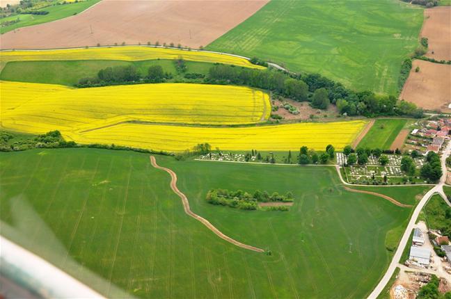
Conservation measures for eroded cropland. The technology contains level ditches of various lengths, which are digged along a contour.
2.2 Descrição detalhada da tecnologia
Descrição:
The structural measures are characterized as small technical structures to control and slow down surface runoff, created after extreme rainfall. The ditch is digged across the slope (along the contour) according to the terrain. Along the four of dithes there were also vegetative strips that should protect and retain rainfall.
Purpose of the Technology: Some damage has been observed on the farmland during storm rainfalls, long-lasting rainfalls, and periods of melting snow. The aim of the conservation measures is to eliminate hazards and damage to health and the economy, to improve the accumulation and infiltration of water into the soil, and to retard the surface runoff on the farmland.
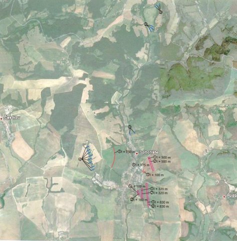
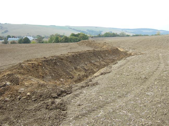
Establishment / maintenance activities and inputs: There are 7 ditches in the area (2842 m in total/ 23873 m3). In the locality of Padelky there are level ditches with lengths of 160 m + 320 m+ 830m = 1310 m; in the locality of Kubíny there are level ditches with lengths of 500 m + 100 m + 175 m = 775 m; in the locality of Šlachovec there is one ditch with the length of 750 m. The total water retention volume is 23873 m3. The ditches are in the shape of a trapezoid with a base width of 1 m, a height according to the terrain, and a slope of 1:1.5 while the digged soil is moved to the lower part of the ditch.
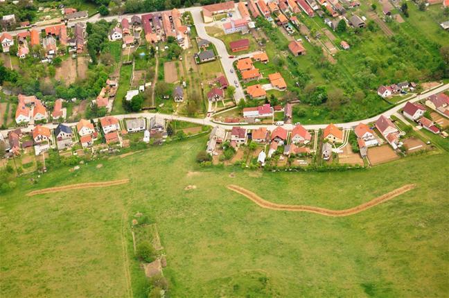
Natural / human environment: Sobotište is a village in the Teplica river basin; it is situated near the town of Senica in the Trnava region of western Slovakia. It is located in a valley at the foothills of the White Carpathians, which are part of the Carpathian Flysch Belt. The sedimentary flysh rocks are erodible, disintegrable, and sensitive to erosion.
2.3 Fotos da tecnologia
Galeria de Mídias
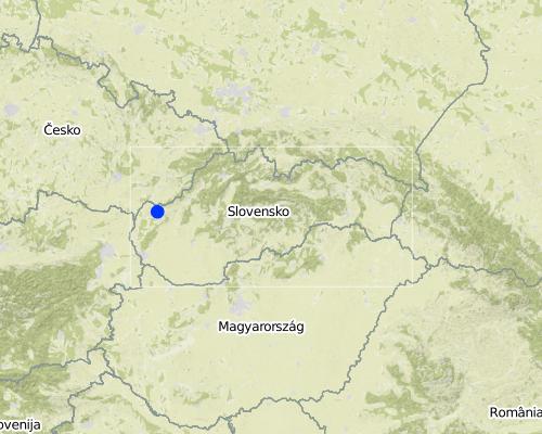
2.5 País/região/locais onde a tecnologia foi aplicada e que estão cobertos nesta avaliação
País:
Eslováquia
Região/Estado/Província:
Slovakia
Especificação adicional de localização:
Sobotište
Map
×3. Classificação da tecnologia de GST
3.2 Tipo(s) atualizado(s) de uso da terra onde a tecnologia foi aplicada

Terra de cultivo
- Cultura anual
Principais plantações (colheitas para venda e consumo próprio):
Major cash crop: Oilseed rape
Comentários:
Major land use problems (compiler’s opinion): The major problem is surface runoff that is formed by extreme rainfall whereby tillage, gully,or interrill erosion is forming.
Major land use problems (land users’ perception): There are some soil threads connected with erosion probably due to agricultural practises and heavy mechanism that are visible e.g.: people had noticed a decrease of the hills peak that is tilled. Some problems with sediments occured after heavy rains, mud flowing directly to the city (cemetery, roads etc.) from the surrounding hills and fields.
Future (final) land use (after implementation of SLM Technology): Cropland: Ca: Annual cropping
Caso o uso da terra tenha mudado devido a implementação da tecnologia, indique seu uso anterior à implementação da tecnologia:
Cropland: Ca: Annual cropping
3.3 Mais informações sobre o uso da terra
Abastecimento de água para a terra na qual a tecnologia é aplicada:
- Misto de precipitação natural-irrigado
Número de estações de cultivo por ano:
- 1
Especifique:
Longest growing period in days: 180Longest growing period from month to month: April to September
3.4 Grupo de GST ao qual pertence a tecnologia
- Medidas de curva de nível
3.5 Difusão da tecnologia
Comentários:
Total area covered by the SLM Technology is 12.4 m2.
Total area of the cropland cover is 12.37 km2 and the eroded area was estimated as 40 % (4.948 km2). This technology is used in the locality of Padelky and Kubina. Together 7 ditches were built. The area of the village 32.3 km2.
3.6 Medidas de GST contendo a tecnologia

Medidas vegetativas
- V2: gramíneas e plantas herbáceas perenes

Medidas estruturais
- S4: Valas de nível, fossos
Comentários:
Main measures: structural measures
Secondary measures: vegetative measures
Type of vegetative measures: aligned: -contour
3.7 Principais tipos de degradação da terra abordados pela tecnologia

Erosão do solo pela água
- Wt: Perda do solo superficial/erosão de superfície
- Wo: efeitos de degradação externa
Comentários:
Main type of degradation addressed: Wt: loss of topsoil / surface erosion
Main causes of degradation: Heavy / extreme rainfall (intensity/amounts) (Slope in connection with heavy rainfall results in surface runoff that causes erosion and mud floods in the part of the city and nearby roads), other natural causes (avalanches, volcanic eruptions, mud flows, highly susceptible natural resources, extreme topography, etc.) specify (mud flows)
Secondary causes of degradation: soil management (tillage along the slopes, deep tillage), land tenure (Land belongs to private owners and there is often a problem to get permission to use their land for other purposes, or to built conservation measures. The process of land consolidation is too long.), governance / institutional (Legislation: The financial support from the state is mainly focused on flood protection for the main rivers.)
3.8 Redução, prevenção ou recuperação da degradação do solo
Especifique o objetivo da tecnologia em relação a degradação da terra:
- Prevenir degradação do solo
- Reduzir a degradação do solo
Comentários:
Main goals: mitigation / reduction of land degradation
Secondary goals: prevention of land degradation
4. Especificações técnicas, implementação de atividades, entradas e custos
4.2 Especificações técnicas/ explicações do desenho técnico
There are 7 ditches in the area (2842 m in total/ 23873 m3). In the locality of Padelky there are level ditches with lengths of 160 m + 320 m+ 830m = 1310 m; in the locality of Kubíny there are level ditches with lengths of 500 m + 100 m + 175 m = 775 m; in the locality of Šlachovec there is one ditch with the length of 750 m. The total water retention volume is 23873 m3. The ditches are in the shape of a trapezoid with a base width of 1 m, a height according to the terrain, and a slope of 1:1.5 while the digged soil is moved to the lower part of the ditch.
Location: Sobotište. Myjava, Slovakia
Technical knowledge required for field staff / advisors: moderate
Technical knowledge required for land users: low
Main technical functions: control of concentrated runoff: retain / trap
Secondary technical functions: reduction of slope length, sediment retention / trapping, sediment harvesting
Aligned: -contour
Vegetative material: O : other
Number of plants per (ha): -
Vertical interval between rows / strips / blocks (m): -
Spacing between rows / strips / blocks (m): -
Vertical interval within rows / strips / blocks (m): -
Width within rows / strips / blocks (m): 40
Other species: Red clover, seeded along the ditch
Retention/infiltration ditch/pit, sediment/sand trap
Depth of ditches/pits/dams (m): 1
Width of ditches/pits/dams (m): 1
Length of ditches/pits/dams (m): various, 2842 m in total
Construction material (earth): The excavated earth is placed on the lower part and mechanically compacted to hold retained water.
Specification of dams/ pans/ ponds: Capacity 23873m3
Catchment area: 12 ham2
4.3 Informação geral em relação ao cálculo de entradas e custos
Outro/moeda nacional (especifique):
Eur
Indique a taxa cambial do dólar norte americano para a moeda local (se relevante): 1 USD =:
0,88
4.4 Atividades de implantação
| Atividade | Tipo de medida | Periodicidade | |
|---|---|---|---|
| 1. | Digging of the ditch for 600 mm width | Estrutural | |
| 2. | Adjustment of the ditch´s embankment | Estrutural | |
| 3. | Digging of the ditch for 600-2000 mm width | Estrutural | |
| 4. | Digging of the ditch for over 2000 mm width | Estrutural | |
| 5. | expert guarantor and planner | Estrutural | |
| 6. | Transfer | Estrutural | |
| 7. | Vegetative strips next to the ditch in 40 m width. Red clover. | Vegetativo | spring |
4.5 Custos e entradas necessárias para a implantação
| Especifique a entrada | Unidade | Quantidade | Custos por unidade | Custos totais por entrada | % dos custos arcados pelos usuários da terra | |
|---|---|---|---|---|---|---|
| Mão-de-obra | Digging of the ditch for 600 mm width | m3 | 9,9 | 18,14 | 179,59 | |
| Mão-de-obra | Adjustment of the ditch´s embankment | m2 | 3861,0 | 0,82 | 3166,02 | |
| Mão-de-obra | Digging of the ditch for 600-2000 mm width | m2 | 5253,0 | 10,24 | 53790,72 | |
| Mão-de-obra | or Digging of the ditch for over 2000 mm width | m2 | 5253,0 | 1,26 | 6618,78 | |
| Material vegetal | Seeds for vegetative strips next to the ditch in 40 m width. Red clover. | kg | 704,0 | 8,15 | 5737,6 | |
| Outros | expert guarantor and planner | person | 1,0 | 3062,61 | 3062,61 | |
| Outros | Transfer | t | 58,655 | 46,11 | 2704,58 | |
| Custos totais para a implantação da tecnologia | 75259,9 | |||||
4.7 Custos e entradas necessárias pata a manutenção/atividades recorrentes (por ano)
Comentários:
Together 7 ditches were built in the study area (1240 ha of cropland). The prices and costs were available as a summary for whole project, therefore the prices correspond for all 7 ditches together. Each of the ditches were slitly different (e.g., the length). The prices are valid for the year 2011. The prices are mostly given for m3 as a unit. (The prices were calculated with the 20% VAT)
4.8 Fatores mais importantes que afetam os custos
Descreva os fatores mais determinantes que afetam os custos:
The costs differ from project to project, it depends on the design, building company atc.
5. Ambiente natural e humano
5.1 Clima
Precipitação pluviométrica anual
- <250 mm
- 251-500 mm
- 501-750 mm
- 751-1.000 mm
- 1.001-1.500 mm
- 1.501-2.000 mm
- 2.001-3.000 mm
- 3.001-4.000 mm
- > 4.000 mm
Zona agroclimática
- Subúmido
Thermal climate class: temperate
5.2 Topografia
Declividade média:
- Plano (0-2%)
- Suave ondulado (3-5%)
- Ondulado (6-10%)
- Moderadamente ondulado (11-15%)
- Forte ondulado (16-30%)
- Montanhoso (31-60%)
- Escarpado (>60%)
Formas de relevo:
- Planalto/planície
- Cumes
- Encosta de serra
- Encosta de morro
- Sopés
- Fundos de vale
Zona de altitude:
- 0-100 m s.n.m.
- 101-500 m s.n.m.
- 501-1.000 m s.n.m.
- 1.001-1.500 m s.n.m.
- 1.501-2.000 m s.n.m.
- 2.001-2.500 m s.n.m.
- 2.501-3.000 m s.n.m.
- 3.001-4.000 m s.n.m.
- > 4.000 m s.n.m.
Comentários e outras especificações sobre a topografia:
Slopes on average: Flat (59%), gentle, (23%) and moderate (9%)
5.3 Solos
Profundidade do solo em média:
- Muito raso (0-20 cm)
- Raso (21-50 cm)
- Moderadamente profundo (51-80 cm)
- Profundo (81-120 cm)
- Muito profundo (>120 cm)
Textura do solo (solo superficial):
- Grosso/fino (arenoso)
Caso disponível anexe a descrição completa do solo ou especifique as informações disponíveis, p. ex. tipo de solo, PH/acidez do solo, nitrogênio, capacidade de troca catiônica, salinidade, etc.
Soil depth on average: Moderately deep (75%), shallow (17%) and very shallow (5%)
Soil texture is coarse/light (34%), fine/heavy (12%) and medium (5%)
Soil fertiliy is medium
Top soil organic matter is unknown
Soil drainage/infiltration is good
Soil water storage capacity is unknown
5.4 Disponibilidade e qualidade de água
Disponibilidade de água de superfície:
Excesso
Qualidade da água (não tratada):
Água potável boa
Comentários e outras especificações sobre a qualidade e a quantidade da água:
Ground water table is unknown
5.5 Biodiversidade
Diversidade de espécies:
- Médio
5.6 Características dos usuários da terra que utilizam a tecnologia
Orientação de mercado do sistema de produção:
- Misto (subsistência/comercial)
- Comercial/mercado
Nível relativo de riqueza:
- Média
Indivíduos ou grupos:
- Grupos/comunidade
Nível de mecanização:
- Mecanizado/motorizado
Gênero:
- Mulheres
- Homens
Indique outras características relevantes dos usuários da terra:
Land users applying the Technology are mainly common / average land users
Difference in the involvement of women and men: no.
Population density: 10-50 persons/km2
Annual population growth: > 4%; 16%
Off-farm income specification: unknown
5.7 Média da área de terra própria ou arrendada por usuários da terra que utilizam a tecnologia
- < 0,5 ha
- 0,5-1 ha
- 1-2 ha
- 2-5 ha
- 5-15 ha
- 15-50 ha
- 50-100 ha
- 100-500 ha
- 500-1.000 ha
- 1.000-10.000 ha
- > 10.000 ha
É considerado pequena, média ou grande escala (referente ao contexto local)?
- Média escala
Comentários:
There are 485 permanently occupied dwellings (2001)
5.8 Propriedade de terra, direitos de uso da terra e de uso da água
Propriedade da terra:
- Comunitário/rural
Direitos do uso da terra:
- Comunitário (organizado)
- Indivíduo
Direitos do uso da água:
- Comunitário (organizado)
- Indivíduo
5.9 Acesso a serviços e infraestrutura
Saúde:
- Pobre
- Moderado
- Bom
Educação:
- Pobre
- Moderado
- Bom
Assistência técnica:
- Pobre
- Moderado
- Bom
Emprego (p. ex. não agrícola):
- Pobre
- Moderado
- Bom
Mercados:
- Pobre
- Moderado
- Bom
Energia:
- Pobre
- Moderado
- Bom
Vias e transporte:
- Pobre
- Moderado
- Bom
Água potável e saneamento:
- Pobre
- Moderado
- Bom
Serviços financeiros:
- Pobre
- Moderado
- Bom
6. Impactos e declarações finais
6.1 Impactos no local mostrados pela tecnologia
Impactos socioeconômicos
Produção
Produção agrícola
Impactos socioculturais
Improved livelihoods and human well-being
Comentários/especificar:
The technology decreased risk of the mud flows that are capable of destroying homes, washing out roads, knocking down trees, and obstructing roadways.
Impactos ecológicos
Ciclo hídrico/escoamento
Escoamento superficial
Solo
Cobertura do solo
Perda de solo
Outros impactos ecológicos
Risk of mud flood
Hazard towards averse events
6.2 Impactos externos mostrados pela tecnologia
Danos na infraestrutura pública/privada
Comentários/especificar:
Reduced risk of flooding and damage of the gardens and household.
Reduced the hazards and damage of the surrounding area by heavy rainfall events.
6.3 Exposição e sensibilidade da tecnologia às mudanças climáticas graduais e extremos/desastres relacionados ao clima (conforme o ponto de vista dos usuários da terra)
Mudança climática gradual
Mudança climática gradual
| Estação do ano | Tipo de mudança climática/extremo | Como a tecnologia lida com isso? | |
|---|---|---|---|
| Temperatura anual | aumento | bem |
Extremos (desastres) relacionados ao clima
Desastres meteorológicos
| Como a tecnologia lida com isso? | |
|---|---|
| Temporal local | não bem |
| Tempestade de vento local | bem |
Desastres climatológicos
| Como a tecnologia lida com isso? | |
|---|---|
| Seca | bem |
Desastres hidrológicos
| Como a tecnologia lida com isso? | |
|---|---|
| Inundação geral (rio) | não bem |
Outras consequências relacionadas ao clima
Outras consequências relacionadas ao clima
| Como a tecnologia lida com isso? | |
|---|---|
| Período de crescimento reduzido | bem |
6.4 Análise do custo-benefício
Como os benefícios se comparam aos custos de implantação (do ponto de vista dos usuários da terra)?
Retornos a curto prazo:
muito positivo
Retornos a longo prazo:
positivo
Como os benefícios se comparam aos custos recorrentes/de manutenção(do ponto de vista dos usuários da terra)?
Retornos a curto prazo:
muito positivo
Retornos a longo prazo:
positivo
Comentários:
There were no maintanance required so far.
6.5 Adoção da tecnologia
Entre todos aqueles que adotaram a tecnologia, quantos adotaram espontaneamente, ou seja, sem receber nenhum incentivo material/pagamentos?
- 0-10%
Comentários:
100% of land user families have adopted the Technology with external material support
Comments on acceptance with external material support: The implementation of the technology was founded by the state (subsidy).
Comments on adoption trend: UNknown
6.7 Pontos fortes/vantagens/oportunidades da tecnologia
| Pontos fortes/vantagens/oportunidades na visão do usuário da terra |
|---|
| The technology shows to be effective, however the rainfall events that have occured so far were not that extreme as before the implementation. |
| Pontos fortes/vantagens/oportunidades na visão do compilador ou de outra pessoa capacitada |
|---|
| The technology is easy to realize. There is no extra knowledge required. The mechanism used to implement the technology is easy to provide. |
6.8 Pontos fracos, desvantagens/riscos da tecnologia e formas de superá-los
| Pontos fracos/desvantagens/riscos na visão do usuário da terra | Como eles podem ser superados? |
|---|---|
| The land users are satisfied with effectivness of the technology. |
| Pontos fracos/vantagens/riscos na visão do compilador ou de outra pessoa capacitada | Como eles podem ser superados? |
|---|---|
| I don´t see any disadvantage or weekness of the technology. |
7. Referências e links
7.2 Referências às publicações disponíveis
Título, autor, ano, ISBN:
Project documentation, Hydrotechnológia Bratislava, s.r.o., April 2011
7.3 Links para informação relevante que está disponível online
URL:
http://www.obecsobotiste.sk/Vodozadrzne-opatrenia.aspx
URL:
https://www.nku.gov.sk/documents/10157/19a2305b-d9c2-43a7-8262-743650db289b
Links e módulos
Expandir tudo Recolher tudoLinks
The programme of landscape revitalization and integrated river … [Eslováquia]
This approach is devoted to the implementation of 'The Landscape Revitalisation Programme and integrated river basins management of the Slovak Republic' in the Sobotište village.
- Compilador/a: Zuzana Studvova
Módulos
Não há módulos