Holistic demonstration [Índia]
- Criação:
- Atualização:
- Compilador/a: Unknown User
- Editor: –
- Revisores: Fabian Ottiger, Alexandra Gavilano
Samagra Jalanayan Abhivrudhi Pratyakshike (Kannada)
technologies_1084 - Índia
Veja as seções
Expandir tudo Recolher tudo1. Informação geral
1.3 Condições em relação ao uso da informação documentada através de WOCAT
O compilador e a(s) pessoa(s) capacitada(s) aceitam as condições relativas ao uso de dados documentados através do WOCAT:
Sim
2. Descrição da tecnologia de GST
2.1 Descrição curta da tecnologia
Definição da tecnologia:
Holistic demonstration includes integrated cultivation of Agri-Horti-Silvi technologies. Along with the Soil & water Conservation structures suitable to the site.
2.2 Descrição detalhada da tecnologia
Descrição:
Holistic demonstration was taken in the upper reach, middle reach and lower reach (2 hectares each) in a village in the watershed. The demonstration units includes soil & water consercvation structures also. Crop demonstration with integrated pest management, seed treatment, pitcher irrigation practices, varietal trails were implemented to increase the overall per capita income of the farmer. However, the suitable SWC was according to the site of lower reach/ upper reach or middle reach. The plot was accommodated with suitable field crops, horticultural species either on the bunds or in the fiels itself and some fodder crops, some forestry species etc.
Purpose of the Technology: The demonstration units now serve as the units of awareness brining in understanding the holistic approach and also to encourage the other farmers to replicate the same in their fields.
Establishment / maintenance activities and inputs: (1) site selection with concerned farmer, (2) design and preparation of estimates by the project staff, (3) discussion with the VWDC and community, (4) discussion regarding contribution with the farmer (5) layout and construction by the project staff with the contribution from the concerned farmers.
Natural / human environment: This technology was taken up in the semi arid condition and in the erratic rainfall condition.
2.3 Fotos da tecnologia
Galeria de Mídias
2.5 País/região/locais onde a tecnologia foi aplicada e que estão cobertos nesta avaliação
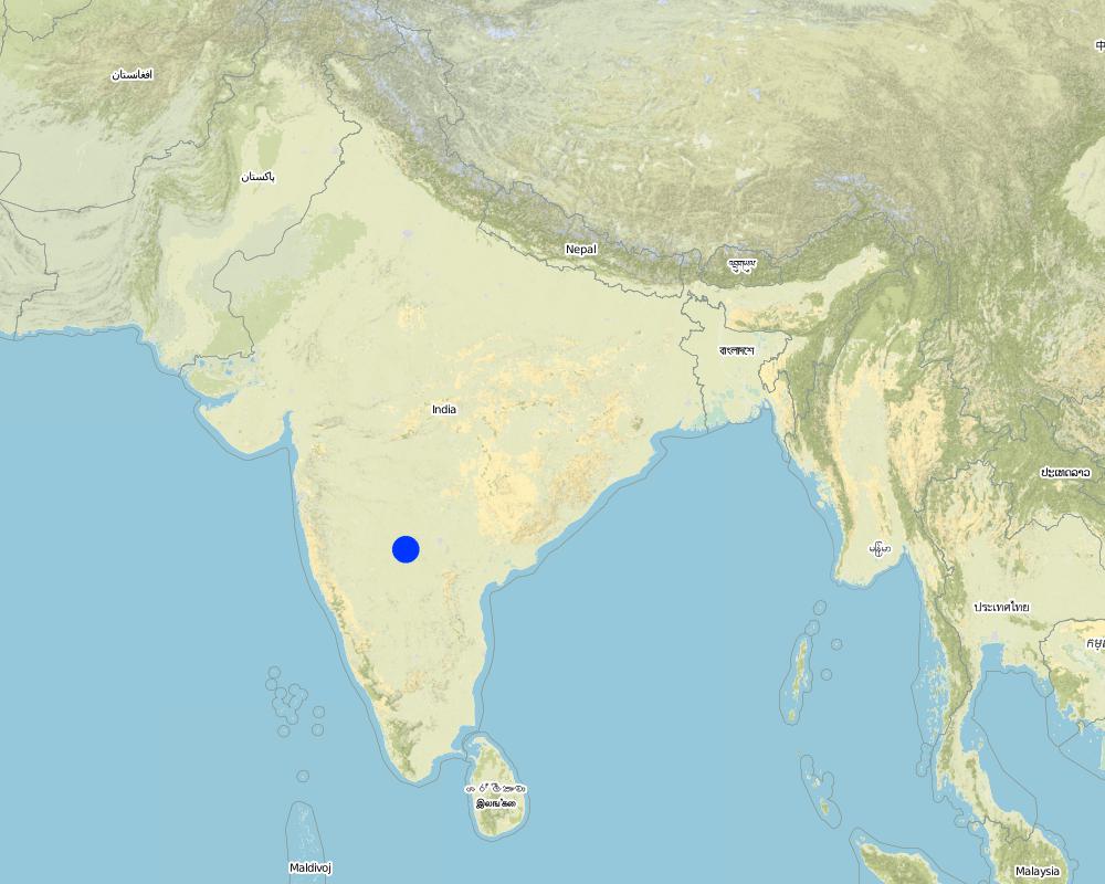
País:
Índia
Região/Estado/Província:
Karnataka
Especificação adicional de localização:
Chitapur taluk of Gulbarga district
Especifique a difusão da tecnologia:
- Uniformemente difundida numa área
Se a Tecnologia estiver uniformemente distribuída por uma área, especifique a área coberta (em km2):
0,12
Se a área precisa não for conhecida, indicar a área aproximada coberta:
- < 0,1 km2 (10 ha)
Comentários:
Total area covered by the SLM Technology is 0.12 km2.
The technology area comprises of 2 ha area each in upper reach, middle reach and lower reach in a village of the watershed. In this area cultivation of agri-horti-silvi practices, agronomic trials, in-situ conservation etc were taken with active involvement of the the farmers.
Map
×2.6 Data da implementação
Caso o ano exato seja desconhecido, indique a data aproximada:
- mais de 50 anos atrás (tradicional)
2.7 Introdução da tecnologia
Especifique como a tecnologia foi introduzida:
- através de projetos/intervenções externas
Comentários (tipos de projeto, etc.):
Mainly from the SWC specialist
3. Classificação da tecnologia de GST
3.1 Principal/principais finalidade(s) da tecnologia
- Melhora a produção
- Reduz, previne, recupera a degradação do solo
3.2 Tipo(s) atualizado(s) de uso da terra onde a tecnologia foi aplicada
Uso do solo misturado dentro da mesma unidade de terra:
Sim
Especificar o uso misto da terra (culturas/ pastoreio/ árvores):
- Agrossilvipecuária

Terra de cultivo
- Cultura anual
- Cultura perene (não lenhosa)
- Cultura de árvores e arbustos
Cultivo anual - Especificar culturas:
- cereais - sorgo
- culturas forrageiras - gramíneas
- Legumes e leguminosas - outras
- legumes e leguminosas - ervilhas
- culturas de sementes - sésamo, papoula, mostarda, outros
Cultivo perene (sem lã) - Especificar culturas:
- plantas medicinais, aromáticas, agrotóxicas - perenes
Cultivo de árvores e arbustos - Especificar culturas:
- cítrico
- frutas, outros
- manga, mangostão, goiaba
- frutas de pomóideas (maçãs, peras, marmelos, etc.)
- Tree croppisapota (cf. Sapotaceae family), drumstick (cf. Moringa oleifera), Tamarind, Gliricidia (Gliricidia sepium perennial, medium-sized (2-15 m high) legume tree) pongama (legume)
Número de estações de cultivo por ano:
- 2
Especifique:
Longest growing period in days: 120 Longest growing period from month to month: Jun - Oct Second longest growing period in days: 120 Second longest growing period from month to month: Nov - Feb

Pastagem
Pastagem extensiva:
- Pastoralismo semi-nômade
- cattle

Floresta/bosques
- Plantação de árvores, reflorestamento
Tipo de árvore:
- Azadirachta indica
- Bambu de bambu
- Tectona grandis
Produtos e serviços:
- Madeira
- Lenha
- Frutas e nozes
- Conservação/proteção da natureza
Comentários:
Major land use problems (compiler’s opinion): Crop land : Low yields due to erosion, less soil moisture, shallow to medium soils. Poor and erratic rainfall, water holding capacity is less.
Major land use problems (land users’ perception): Crop land - Uncertain rainfall, more soil loss and poor yields.
Semi-nomadism / pastoralism: the village cattle are let free for grazing on the common land for some time in the day and they go back and then I is again stall feeding.
Plantation forestry: Yes
Other type of forest: others (scattered)
Type of cropping system and major crops comments: During kharif (monsoon) season the main crop is redgram (Tur), in addition few cereals were taken, followed by jowar in the major rabi (post-monsoon) crop. No cultivation was o\bserved in summer, farmer are now cultivating vegetable and fruit crop,
Trees/ shrubs species: Neem, Glyricdia, Pongamia, Bamboo
Fruit trees / shrubs species: Mango. Tamarind, Lime, Sapota, Clustard apple
Grass species: Napiar
3.4 Abastecimento de água
Abastecimento de água para a terra na qual a tecnologia é aplicada:
- Precipitação natural
Comentários:
Water supply: Also mixed rainfed - irrigated and post-flooding (both ranked 2)
3.5 Grupo de GST ao qual pertence a tecnologia
- Perturbação mínima ao solo
- Gestão integrada de pragas e doenças (inclusive agricultura orgânica)
- Gestão de irrigação (inclusive abastecimento de água, drenagem)
3.6 Medidas de GST contendo a tecnologia
3.7 Principais tipos de degradação da terra abordados pela tecnologia

Erosão do solo pela água
- Wt: Perda do solo superficial/erosão de superfície
- Wg: Erosão por ravinas/ravinamento
Comentários:
Main type of degradation addressed: Wg: gully erosion / gullying
Secondary types of degradation addressed: Wt: loss of topsoil / surface erosion
Main causes of degradation: other natural causes (avalanches, volcanic eruptions, mud flows, highly susceptible natural resources, extreme topography, etc.) specify, poverty / wealth (lack of captial)
Secondary causes of degradation: other human induced causes (specify) (other (migration)), labour availability (lack of labour, cost of labour), education, access to knowledge and support services (lack of knowledge)
3.8 Redução, prevenção ou recuperação da degradação do solo
Especifique o objetivo da tecnologia em relação a degradação da terra:
- Reduzir a degradação do solo
- Recuperar/reabilitar solo severamente degradado
Comentários:
Main goals: mitigation / reduction of land degradation
Secondary goals: rehabilitation / reclamation of denuded land
4. Especificações técnicas, implementação de atividades, entradas e custos
4.1 Desenho técnico da tecnologia
Especificações técnicas (relacionada ao desenho técnico):
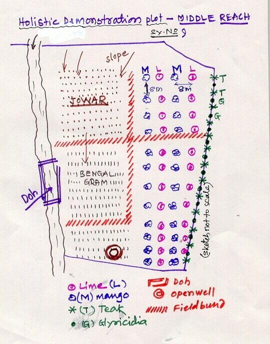
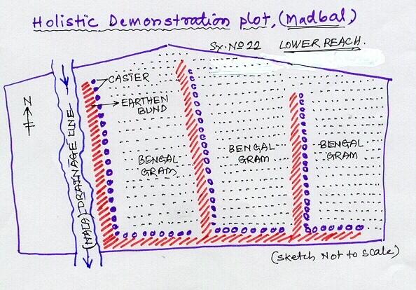
Lower Reach holistic demonstration plot showing various soil & moisture conservation structures, field crops and bund stabilization by vegetation.
Location: Bennur-B nala watershed Chitapur taluk. Chitapur taluk, Gulbarga District (Karnataka state
Date: 20.4.2004
Technical knowledge required for field staff / advisors: high
Technical knowledge required for land users: high
Main technical functions: increase in organic matter, water harvesting / increase water supply, increase in soil fertility
Secondary technical functions: control of dispersed runoff: retain / trap, control of concentrated runoff: retain / trap, improvement of ground cover, sediment retention / trapping, sediment harvesting
Mixed cropping / intercropping
Material/ species: saplings
Quantity/ density: 100
Remarks: layout
Contour planting / strip cropping
Material/ species: sapplings
Quantity/ density: 360
Remarks: layout
Legume inter-planting
Quantity/ density: 200
Remarks: layout
Agronomic measure: others (vermicompost)
Material/ species: material
Minimum tillage
Remarks: material
Aligned: -contour
Vegetative material: G : grass
Number of plants per (ha): 100
Vertical interval between rows / strips / blocks (m): 1
Vertical interval within rows / strips / blocks (m): 0.5
Scattered / dispersed
Vegetative material: T : trees / shrubs
Number of plants per (ha): 500
Trees/ shrubs species: Neem, Glyricdia, Pongamia, Bamboo
Fruit trees / shrubs species: Mango. Tamarind, Lime, Sapota, Clustard apple
Grass species: Napiar
Slope (which determines the spacing indicated above): 3.00%
If the original slope has changed as a result of the Technology, the slope today is (see figure below): 2.00%
Gradient along the rows / strips: 1.00%
Dam/ pan/ pond
Vertical interval between structures (m): 4
Spacing between structures (m): 50
Depth of ditches/pits/dams (m): 3
Width of ditches/pits/dams (m): 12
Length of ditches/pits/dams (m): 12
Height of bunds/banks/others (m): 3
Width of bunds/banks/others (m): 12
Length of bunds/banks/others (m): 12
Bund/ bank: semi-circular/V shaped trapezoidal
Vertical interval between structures (m): 4
Spacing between structures (m): 50
Depth of ditches/pits/dams (m): 0
Width of ditches/pits/dams (m): 3
Length of ditches/pits/dams (m): 50
Height of bunds/banks/others (m): 0.9
Width of bunds/banks/others (m): 3
Length of bunds/banks/others (m): 50
Structural measure: pit, sediment sand / trap
Vertical interval between structures (m): 1
Spacing between structures (m): 30-40
Depth of ditches/pits/dams (m): 0.3
Width of ditches/pits/dams (m): 0.3
Length of ditches/pits/dams (m): 6
Height of bunds/banks/others (m): 0.9
Width of bunds/banks/others (m): 3
Length of bunds/banks/others (m): 50
Structural measure: other (brushwood dam)
Vertical interval between structures (m): 1
Spacing between structures (m): 80
Depth of ditches/pits/dams (m): 0
Width of ditches/pits/dams (m): 1
Length of ditches/pits/dams (m): 6
Height of bunds/banks/others (m): 0.9
Width of bunds/banks/others (m): 0
Length of bunds/banks/others (m): 0
Slope (which determines the spacing indicated above): 1%
If the original slope has changed as a result of the Technology, the slope today is: 2%
Lateral gradient along the structure: 1%
For water harvesting: the ratio between the area where the harvested water is applied and the total area from which water is collected is: 1:10
Vegetation is used for stabilisation of structures.
Change of land use type: Multidimensional participatory holistic farming system, fallow to cultivable land
Autor:
GK Ron, JPO KWDP Danida Bijapu
4.2 Informação geral em relação ao cálculo de entradas e custos
Outro/moeda nacional (especifique):
Rupees
Se for relevante, indique a taxa de câmbio do USD para moeda local (por exemplo, 1 USD = 79,9 Real): 1 USD =:
46,0
Indique a média salarial da mão-de-obra contratada por dia:
0.73
4.3 Atividades de implantação
| Atividade | Periodicidade (estação do ano) | |
|---|---|---|
| 1. | Digging of pits | Sumer |
| 2. | Procurement of seed/ seedlings | Before rainy season |
| 3. | Sowing of grass, shrub seeds | After first shower |
| 4. | Planting of sappling | After first shower |
| 5. | Survey/ layout | April |
| 6. | Excavation of ditches | may |
| 7. | Transportation of stones to the site | May |
| 8. | Construction of bunds, farm pond | may |
| 9. | Construction of brushwood dam, doh | June |
| 10. | Training, capacity building of the farmer | february - March |
| 11. | Establishment of sructural measures | April-June |
| 12. | establishment of vegetative measures | July-September |
4.4 Custos e entradas necessárias para a implantação
| Especifique a entrada | Unidade | Quantidade | Custos por unidade | Custos totais por entrada | % dos custos arcados pelos usuários da terra | |
|---|---|---|---|---|---|---|
| Mão-de-obra | Labour | ha | 1,0 | 510,0 | 510,0 | 10,0 |
| Material vegetal | Seeds | ha | 1,0 | 114,0 | 114,0 | 3,0 |
| Material vegetal | Seedlings | ha | 1,0 | 169,0 | 169,0 | 74,0 |
| Fertilizantes e biocidas | fertilizer | ha | 1,0 | 157,0 | 157,0 | |
| Fertilizantes e biocidas | Biocides | ha | 1,0 | 76,0 | 76,0 | |
| Fertilizantes e biocidas | Compost/manure | ha | 1,0 | 15,0 | 15,0 | 10,0 |
| Material de construção | Stone | ha | 1,0 | 110,0 | 110,0 | 3,0 |
| Material de construção | Wood | ha | 1,0 | 10,0 | 10,0 | 3,0 |
| Material de construção | Earth | ha | 1,0 | 26,0 | 26,0 | 2,0 |
| Outros | Pitcher pots | ha | 1,0 | 72,0 | 72,0 | |
| Custos totais para a implantação da tecnologia | 1259,0 | |||||
| Custos totais para o estabelecimento da Tecnologia em USD | 27,37 | |||||
Comentários:
Duration of establishment phase: 36 month(s)
4.5 Atividades recorrentes/manutenção
| Atividade | Periodicidade/frequência | |
|---|---|---|
| 1. | Mulching | Summer / each cropping season |
| 2. | Across slope ploughing | Summer / each cropping season |
| 3. | In-situ maisture conservation | before sowing / |
| 4. | Watering | summer /once in 10 days |
| 5. | Weeding, mulching | 2-3 months after planting /twice in a year |
| 6. | Re-seeding of grass/ shrub | before first shower /up to 2 years |
| 7. | casualty replacement | before first shower /1, 2, and 3rd years |
| 8. | fencing | during sumer period /every summer season of 2nd, 3rd and 4th year |
| 9. | Repair of breaches in bund | July to september/as required |
| 10. | Desilting of traps | October-November/annual |
| 11. | Refresher interaction with farmer | / seasonally |
| 12. | Rgular meetings | / as and when required |
4.6 Custos e entradas necessárias pata a manutenção/atividades recorrentes (por ano)
| Especifique a entrada | Unidade | Quantidade | Custos por unidade | Custos totais por entrada | % dos custos arcados pelos usuários da terra | |
|---|---|---|---|---|---|---|
| Mão-de-obra | Labour | ha | 1,0 | 51,0 | 51,0 | 100,0 |
| Material vegetal | Seeds | ha | 1,0 | 11,1 | 11,1 | 100,0 |
| Material vegetal | Seedlings | ha | 1,0 | 16,9 | 16,9 | 100,0 |
| Fertilizantes e biocidas | Fertilizer | ha | 1,0 | 15,7 | 15,7 | |
| Fertilizantes e biocidas | Biocides | ha | 1,0 | 7,6 | 7,6 | |
| Material de construção | Stone | ha | 1,0 | 11,0 | 11,0 | 100,0 |
| Material de construção | Wood | ha | 1,0 | 1,0 | 1,0 | 100,0 |
| Material de construção | Earth | ha | 1,0 | 2,6 | 2,6 | 100,0 |
| Outros | Pitcher pots | ha | 1,0 | 7,2 | 7,2 | 100,0 |
| Custos totais para a manutenção da tecnologia | 124,1 | |||||
| Custos totais de manutenção da Tecnologia em USD | 2,7 | |||||
4.7 Fatores mais importantes que afetam os custos
Descreva os fatores mais determinantes que afetam os custos:
Non availability of stones, boulders
5. Ambiente natural e humano
5.1 Clima
Precipitação pluviométrica anual
- <250 mm
- 251-500 mm
- 501-750 mm
- 751-1.000 mm
- 1.001-1.500 mm
- 1.501-2.000 mm
- 2.001-3.000 mm
- 3.001-4.000 mm
- > 4.000 mm
Especificações/comentários sobre a pluviosidade:
750-800 mm
5.2 Topografia
Declividade média:
- Plano (0-2%)
- Suave ondulado (3-5%)
- Ondulado (6-10%)
- Moderadamente ondulado (11-15%)
- Forte ondulado (16-30%)
- Montanhoso (31-60%)
- Escarpado (>60%)
Formas de relevo:
- Planalto/planície
- Cumes
- Encosta de serra
- Encosta de morro
- Sopés
- Fundos de vale
Zona de altitude:
- 0-100 m s.n.m.
- 101-500 m s.n.m.
- 501-1.000 m s.n.m.
- 1.001-1.500 m s.n.m.
- 1.501-2.000 m s.n.m.
- 2.001-2.500 m s.n.m.
- 2.501-3.000 m s.n.m.
- 3.001-4.000 m s.n.m.
- > 4.000 m s.n.m.
Comentários e outras especificações sobre a topografia:
Altitudinal zone: 101-500 m a.s.l. (422.8 m a.s.l.)
Landforms: Plateu/plains (3-4% slope, ranked 1), ridges (ranked 2)
Slopes on average: Gentle (3-4%)
5.3 Solos
Profundidade do solo em média:
- Muito raso (0-20 cm)
- Raso (21-50 cm)
- Moderadamente profundo (51-80 cm)
- Profundo (81-120 cm)
- Muito profundo (>120 cm)
Textura do solo (solo superficial):
- Grosso/fino (arenoso)
- Médio (limoso, siltoso)
Matéria orgânica do solo superficial:
- Baixo (<1%)
Caso disponível anexe a descrição completa do solo ou especifique as informações disponíveis, p. ex. tipo de solo, PH/acidez do solo, nitrogênio, capacidade de troca catiônica, salinidade, etc.
Soil depth on average: Moderately deep (60 cm, ranked 1) and deep (ranked 2)
Soil fertility: Medium (eroded soils)
Topsoil organic matter: Low (absence of vegetation)
Soil drainage/infiltration: Poor (high run-off from stony surface)
Soil water storage capacity: Very low
5.6 Características dos usuários da terra que utilizam a tecnologia
Orientação de mercado do sistema de produção:
- Subsistência (autoabastecimento)
- misto (subsistência/comercial)
Rendimento não agrícola:
- Menos de 10% de toda renda
Nível relativo de riqueza:
- Muito pobre
- Pobre
Indique outras características relevantes dos usuários da terra:
Population density: 50-100 persons/km2
Annual population growth: 0.5% - 1%
7% of the land users are average wealthy and own 26% of the land.
65% of the land users are poor and own 58% of the land.
28% of the land users are poor and own 16% of the land.
Off-farm income specification: Off season employment
5.7 Área média de terrenos utilizados pelos usuários de terrenos que aplicam a Tecnologia
- < 0,5 ha
- 0,5-1 ha
- 1-2 ha
- 2-5 ha
- 5-15 ha
- 15-50 ha
- 50-100 ha
- 100-500 ha
- 500-1.000 ha
- 1.000-10.000 ha
- > 10.000 ha
Comentários:
Average area of land owned or leased by land users applying the Technology:
Cropland: 0.5-1 ha: Joint farmers, land shared by brothers (ranked 1), 1-2 ha (ranked 2), 2-5 ha (ranked 3)
Grazing land: 0.5-1 ha: Not much grazing land is available in the village.
5.8 Propriedade de terra, direitos de uso da terra e de uso da água
Propriedade da terra:
- Indivíduo, intitulado
Direitos do uso da terra:
- Indivíduo
6. Impactos e declarações finais
6.1 Impactos no local mostrados pela tecnologia
Impactos socioeconômicos
Produção
Produção agrícola
Comentários/especificar:
Drought from last 3 years
Produção de forragens
Qualidade da forragem
Produção de madeira
Área de produção
Comentários/especificar:
SWC takes small piece of cultivable land
Renda e custos
Rendimento agrícola
Impactos socioculturais
Instituições comunitárias
Comentários/especificar:
Village watershed development committee, users groups etc.
Instituições nacionais
Conhecimento de GST/ degradação da terra
Atenuação de conflitos
Comentários/especificar:
Project support is expected by most of the farmers at a time.
Impactos ecológicos
Solo
Umidade do solo
Cobertura do solo
Comentários/especificar:
Area was previously barren
Perda de solo
Comentários/especificar:
Good vegetative cover
Biodiversidade: vegetação, animais
Biomassa/carbono acima do solo
Comentários/especificar:
Ground cover established with vegetative hedges.
Clima e redução de riscos de desastre
Velocidade do vento
Outros impactos ecológicos
Soil fertility
Comentários/especificar:
Introduction of legume species (glyricidia)
Biodiversity
Waterlogging
Comentários/especificar:
Not a genereal problem. But only on this plot.
6.2 Impactos externos mostrados pela tecnologia
Caudal confiável e estável em período seco
Cheias de jusante
Comentários/especificar:
In-situ conservation
Sedimentos transportados pelo vento
Comentários/especificar:
Establishment of ground covers
6.4 Análise do custo-benefício
Como os benefícios se comparam aos custos de implantação (do ponto de vista dos usuários da terra)?
Retornos a curto prazo:
neutro/balanceado
Retornos a longo prazo:
positivo
Como os benefícios se comparam aos custos recorrentes/de manutenção(do ponto de vista dos usuários da terra)?
Retornos a curto prazo:
positivo
Retornos a longo prazo:
positivo
6.5 Adoção da tecnologia
Se disponível, determine a quantidade (número de unidades familiares e/ou área abordada):
452
De todos aqueles que adotaram a Tecnologia, quantos o fizeram espontaneamente, ou seja, sem receber nenhum incentivo/ pagamento material?
- 0-10%
Comentários:
60% of land user families have adopted the Technology with external material support
417 land user families have adopted the Technology with external material support
Comments on acceptance with external material support: survey results
5% of land user families have adopted the Technology without any external material support
35 land user families have adopted the Technology without any external material support
Comments on spontaneous adoption: survey results
There is a moderate trend towards spontaneous adoption of the Technology
Comments on adoption trend: Overall returns fro\m the piece of land is increased owing to horticulture and agriculture crops. Biomass increases. This is seen by other farmers and they are motivated to go for its adaption.
6.7 Pontos fortes/vantagens/oportunidades da tecnologia
| Pontos fortes/vantagens/oportunidades na visão do usuário da terra |
|---|
|
Economic sustainability How can they be sustained / enhanced? vegetative and green manure vermicompost etc. |
| Pontos fortes/vantagens/oportunidades na visão do compilador ou de outra pessoa capacitada |
|---|
|
Effective SWC How can they be sustained / enhanced? maibntenance by the individual farmers |
|
water harvesting How can they be sustained / enhanced? Desilting structure |
|
Integrated approach How can they be sustained / enhanced? regular contact |
|
increased production How can they be sustained / enhanced? Integrated cultivation |
6.8 Pontos fracos, desvantagens/riscos da tecnologia e formas de superá-los
| Pontos fracos/desvantagens/riscos na visão do usuário da terra | Como eles podem ser superados? |
|---|---|
| Production (benefits) adversly affected due to drought. | Due to longer dry spel in the area (last three years) |
| Pontos fracos/vantagens/riscos na visão do compilador ou de outra pessoa capacitada | Como eles podem ser superados? |
|---|---|
| Non-availability of agricultural improved seed material at local level | by linkage of VWDCs with the Agricultural Research Station and Krishi Vignyan Kendra. |
| conflicts | demands by more number of farmers could not be met by the project at a time. |
7. Referências e links
7.1 Métodos/fontes de informação
Links e módulos
Expandir tudo Recolher tudoLinks
Não há links
Módulos
Não há módulos