Shelterbelts [Índia]
- Criação:
- Atualização:
- Compilador/a: Unknown User
- Editor: –
- Revisores: Fabian Ottiger, Alexandra Gavilano
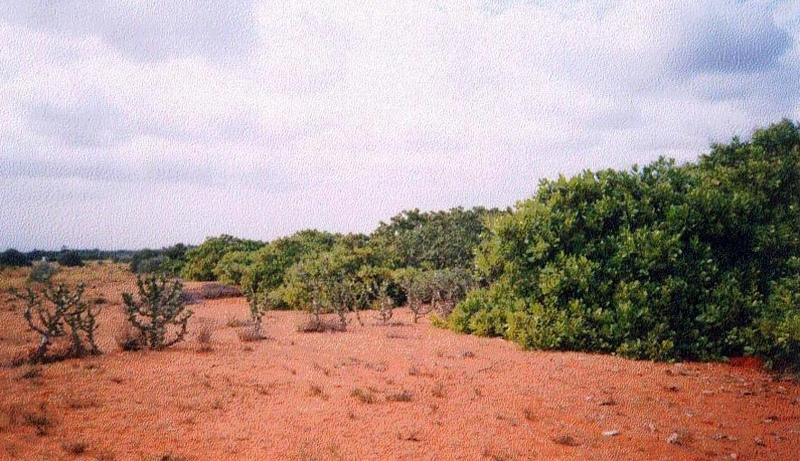
Line, Shelterbelts in Theri land
technologies_1473 - Índia
Veja as seções
Expandir tudo Recolher tudo1. Informação geral
1.3 Condições em relação ao uso da informação documentada através de WOCAT
O/a compilador/a e a(s) pessoa(s) capacitada(s) aceitam as condições relativas ao uso de dados documentados através da WOCAT:
Sim
2. Descrição da tecnologia de GST
2.1 Descrição curta da tecnologia
Definição da tecnologia:
Cultivation of tree belts across the direction of wind at appropriate intervals in the deposition zone, with a view to arrest wind erosion and facilitate stabilisation of dunes through interbelt development.
2.2 Descrição detalhada da tecnologia
Descrição:
The technology comprises establishment of 5 row shelterbelts at 160 m intervals. 3 row intermediary shelterbelts are introduced in between existing shelterbelts at 80 m interval. Land owners are encouraged to cultivate tree crops in between the belts.
Purpose of the Technology: Shelterbelts are useful in reducing wind velocity, there by arresting shifting of sand dunes, deposition of sand on fields, habitation, wells, roads etc. Cultivation of area between tree belts is made possible leading to increase in productivity from these lands.
Establishment / maintenance activities and inputs: The shelterbelts comprise tree species of different heights planted in rows (5 and 3 row deep) in a straight line across the wind direction. Six month old seedlings are planted in pits of volume 1 cuft to 1.5 cuft, which are filled with tank silt. One borewell is provided for one km length for life saving irrigation.
Natural / human environment: The environment is arid and forms the deposition zone wherein sand lifted from the impact zone is deposited. Sand dunes cover the area.
2.3 Fotos da tecnologia
Galeria de Mídias
2.5 País/região/locais onde a tecnologia foi aplicada e que estão cobertos nesta avaliação
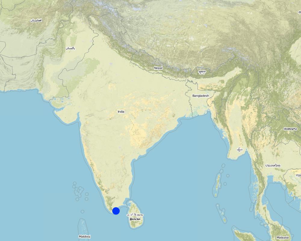
País:
Índia
Região/Estado/Província:
Tirunelveli district, Tamil nadu state
Comentários:
Total area covered by the SLM Technology is 100 km2.
The technology was implemented in the sand dune belt locally known as 'theri', located between the western mountain range and east coast of south India. The technology was initially implemented by the Government of Tamil nadu state in 1978 till 1985. The Danida supported project implemented by the department of Agricultural Engineering began activities to strengthen existing shelter belts, introduce inter belts and mass plantation from 1991 till 1999. The technology was initially implemented in an area much wider than the their lands, but experience showed that the shelterbelts was not the best methodology for low wind agricultural areas, so a shift to agro forestry and mass planting occurred.
Map
×2.6 Data da implementação
Caso o ano exato seja desconhecido, indique a data aproximada:
- menos de 10 anos atrás (recentemente)
2.7 Introdução da tecnologia
Especifique como a tecnologia foi introduzida:
- através de projetos/intervenções externas
Comentários (tipos de projeto, etc.):
The Department of Agriculture Engineering implemented shelterbelts since 1958 in neighbouring Madurai district. The technology was introduced to Tirunelveli district by the department in 1978 wherein 5 row shelterbelts were established.
3. Classificação da tecnologia de GST
3.1 Principal/principais finalidade(s) da tecnologia
- Melhora a produção
- Preserva ecossistema
3.2 Tipo(s) atualizado(s) de uso da terra onde a tecnologia foi aplicada
Uso do solo misturado dentro da mesma unidade de terra:
Sim
Especificar o uso misto da terra (culturas/ pastoreio/ árvores):
- Agrossilvipecuária

Terra de cultivo
Número de estações de cultivo por ano:
- 1
Especifique:
Longest growing period in days: 100 Longest growing period from month to month: Oct - Dec

Pastagem

Floresta/bosques
- Plantação de árvores, reflorestamento
Produtos e serviços:
- Proteção contra desastres naturais
Comentários:
Major land use problems (compiler’s opinion): Crops cannot be cultivated due to sand deposition. Grass cover cannot develop due to shifting of dunes. Hence the area is neglected and degrades further. Only hardy species (ef. Palymra) and coarse grasses survive. Predominant land use is open grazing.
Major land use problems (land users’ perception): Land cannot be cultivated economically due to arid conditions, shifting dunes and open grazing.
Type of cropping system and major crops comments: Cultivation is practiced only in years of good rainfall. Single crop of pulse (black gram ) is taken.
3.4 Abastecimento de água
Abastecimento de água para a terra na qual a tecnologia é aplicada:
- Precipitação natural
Comentários:
Water supply: Also mixed rainfed - irrigated (ranked 2)
3.5 Grupo de GST ao qual pertence a tecnologia
- Quebra-vento/cerca de árvores
3.7 Principais tipos de degradação da terra abordados pela tecnologia

Erosão do solo pelo vento
- Ed: deflação e deposição
- Eo: efeitos de degradação externa
Comentários:
Main type of degradation addressed: Eo: offsite degradation effects
Secondary types of degradation addressed: Ed: deflation and deposition
4. Especificações técnicas, implementação de atividades, entradas e custos
4.1 Desenho técnico da tecnologia
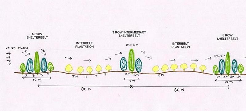
Especificações técnicas (relacionada ao desenho técnico):
Technical Drawing - Shelterbelt
Technical knowledge required for field staff / advisors: high
Technical knowledge required for land users: moderate
Main technical functions: reduction in wind speed
Secondary technical functions: improvement of ground cover, arresting movement of sand
Slope (which determines the spacing indicated above): 2.00%
Autor:
David Gandhi, India
4.2 Informação geral em relação ao cálculo de entradas e custos
Outro/moeda nacional (especifique):
Indian Rupee
Se for relevante, indique a taxa de câmbio do USD para moeda local (por exemplo, 1 USD = 79,9 Real): 1 USD =:
48,85
Indique a média salarial da mão-de-obra contratada por dia:
1.00
4.3 Atividades de implantação
| Atividade | Periodicidade (estação do ano) | |
|---|---|---|
| 1. | Nursery raising | May-Nov |
| 2. | Pitting | Oct-Nov |
| 3. | Filling of pits | Nov-Dec at plantation |
| 4. | Life watering | Nov-Dec at plantation |
| 5. | Periodic watering | weekly during 1st year, except monsoon |
| 6. | Provision of shade to saplings | at planting |
4.4 Custos e entradas necessárias para a implantação
Comentários:
Duration of establishment phase: 60 month(s)
4.5 Atividades recorrentes/manutenção
| Atividade | Periodicidade/frequência | |
|---|---|---|
| 1. | Watering | 2 & 3rd year after plantation /fortnightly, except monsoon |
| 2. | Casualty replacement | 2nd year /monsoon |
| 3. | Watch & ward | upto 5th year /full time watchman |
4.7 Fatores mais importantes que afetam os custos
Descreva os fatores mais determinantes que afetam os custos:
The above costs cover an establishment period of 5 years for 1 hectare (250 plants) of shelterbelt; year 1: pitting, planting, watering. Year 2 & 3: periodic watering, watch and ward, prunng, gap filling. Year 4 & 5: watch and ward, pruning. Of the total number of 391 mandays/ha. of shelterbelt, 288 mandays go towards periodic watering over the first 3 years. Watering of plants is essential due to the semi-arid climate and sandy soil. In addition, as supportive technology for provision of water, one borewell with handpump was established per kilometer of shelterbelt.
5. Ambiente natural e humano
5.1 Clima
Precipitação pluviométrica anual
- <250 mm
- 251-500 mm
- 501-750 mm
- 751-1.000 mm
- 1.001-1.500 mm
- 1.501-2.000 mm
- 2.001-3.000 mm
- 3.001-4.000 mm
- > 4.000 mm
Especifique a média pluviométrica anual em mm (se conhecida):
559,00
Especificações/comentários sobre a pluviosidade:
30 years average
Zona agroclimática
- Semiárido
Since past few years, arid conditions prevail
5.2 Topografia
Declividade média:
- Plano (0-2%)
- Suave ondulado (3-5%)
- Ondulado (6-10%)
- Moderadamente ondulado (11-15%)
- Forte ondulado (16-30%)
- Montanhoso (31-60%)
- Escarpado (>60%)
Formas de relevo:
- Planalto/planície
- Cumes
- Encosta de serra
- Encosta de morro
- Sopés
- Fundos de vale
Zona de altitude:
- 0-100 m s.n.m.
- 101-500 m s.n.m.
- 501-1.000 m s.n.m.
- 1.001-1.500 m s.n.m.
- 1.501-2.000 m s.n.m.
- 2.001-2.500 m s.n.m.
- 2.501-3.000 m s.n.m.
- 3.001-4.000 m s.n.m.
- > 4.000 m s.n.m.
Comentários e outras especificações sobre a topografia:
Landforms: Plateau/plains (undulating terrain)
Slopes on average: Gentle (undulating)
5.3 Solos
Profundidade do solo em média:
- Muito raso (0-20 cm)
- Raso (21-50 cm)
- Moderadamente profundo (51-80 cm)
- Profundo (81-120 cm)
- Muito profundo (>120 cm)
Textura do solo (solo superficial):
- Grosso/fino (arenoso)
Matéria orgânica do solo superficial:
- Baixo (<1%)
Caso disponível anexe a descrição completa do solo ou especifique as informações disponíveis, p. ex. tipo de solo, PH/acidez do solo, nitrogênio, capacidade de troca catiônica, salinidade, etc.
Soil depth on average: Very deep (due to deposition by wind)
Soil texture: Coarse/light (sandy soil),
Soil fertility: Very low (low organic matter)
Topsoil organic matter: Low (low vegetative cover)
Soil drainage/infiltration: Good (permeability is high)
Soil water storage capacity: Very low (sandy soil, low organic matter)
5.6 Características dos usuários da terra que utilizam a tecnologia
Rendimento não agrícola:
- >50% de toda renda
Nível relativo de riqueza:
- Pobre
- Média
Nível de mecanização:
- Trabalho manual
Indique outras características relevantes dos usuários da terra:
Population density: 50-100 persons/km2
Annual population growth: 1% - 2%
38% of the land users are average wealthy (traders, labor).
42% of the land users are poor (small farmers, without water source).
20% of the land users are poor (small farmers, without water source).
Off-farm income specification: traders, employed in cashew processing plants, small industries, nearby towns, migration.
Level of mechanization: Manual work (in addition bullocks are used for ploughing)
5.8 Propriedade de terra, direitos de uso da terra e de uso da água
Propriedade da terra:
- Indivíduo, intitulado
Direitos do uso da terra:
- Acesso livre (não organizado)
6. Impactos e declarações finais
6.4 Análise do custo-benefício
Como os benefícios se comparam aos custos de implantação (do ponto de vista dos usuários da terra)?
Retornos a curto prazo:
muito negativo
Retornos a longo prazo:
positivo
Como os benefícios se comparam aos custos recorrentes/de manutenção(do ponto de vista dos usuários da terra)?
Retornos a curto prazo:
levemente negativo
Retornos a longo prazo:
muito positivo
6.5 Adoção da tecnologia
De todos aqueles que adotaram a Tecnologia, quantos o fizeram espontaneamente, ou seja, sem receber nenhum incentivo/ pagamento material?
- 0-10%
Comentários:
100% of land user families have adopted the Technology with external material support
5000 land user families have adopted the Technology with external material support
Comments on acceptance with external material support: estimates
There is a little trend towards spontaneous adoption of the Technology
Comments on adoption trend: Farmers are in favour of raising orchards to combat wind erosion and increase production in place of shelterbelts..
7. Referências e links
7.1 Métodos/fontes de informação
7.2 Referências às publicações disponíveis
Título, autor, ano, ISBN:
Review Reports
Disponível de onde? Custos?
Chief Engineer, Agriculture Engineering Department, Anna Salai-439, Nandanam, Chennai-600035
Título, autor, ano, ISBN:
Project Implementation Plans, Project documents
Disponível de onde? Custos?
Programme Coordinator, WDCU, 11/1 Sarvapriya Vihar, New Delhi-110016.
Links e módulos
Expandir tudo Recolher tudoLinks
Não há links
Módulos
Não há módulos