Shelterbelts [Inde]
- Création :
- Mise à jour :
- Compilateur : Unknown User
- Rédacteur : –
- Examinateurs : Fabian Ottiger, Alexandra Gavilano
Line, Shelterbelts in Theri land
technologies_1473 - Inde
Voir les sections
Développer tout Réduire tout1. Informations générales
1.3 Conditions relatives à l'utilisation par WOCAT des données documentées
Le compilateur et la(les) personne(s) ressource(s) acceptent les conditions relatives à l'utilisation par WOCAT des données documentées:
Oui
2. Description de la Technologie de GDT
2.1 Courte description de la Technologie
Définition de la Technologie:
Cultivation of tree belts across the direction of wind at appropriate intervals in the deposition zone, with a view to arrest wind erosion and facilitate stabilisation of dunes through interbelt development.
2.2 Description détaillée de la Technologie
Description:
The technology comprises establishment of 5 row shelterbelts at 160 m intervals. 3 row intermediary shelterbelts are introduced in between existing shelterbelts at 80 m interval. Land owners are encouraged to cultivate tree crops in between the belts.
Purpose of the Technology: Shelterbelts are useful in reducing wind velocity, there by arresting shifting of sand dunes, deposition of sand on fields, habitation, wells, roads etc. Cultivation of area between tree belts is made possible leading to increase in productivity from these lands.
Establishment / maintenance activities and inputs: The shelterbelts comprise tree species of different heights planted in rows (5 and 3 row deep) in a straight line across the wind direction. Six month old seedlings are planted in pits of volume 1 cuft to 1.5 cuft, which are filled with tank silt. One borewell is provided for one km length for life saving irrigation.
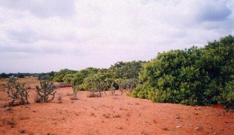
Natural / human environment: The environment is arid and forms the deposition zone wherein sand lifted from the impact zone is deposited. Sand dunes cover the area.
2.3 Photos de la Technologie
Galerie Médias
2.5 Pays/ région/ lieux où la Technologie a été appliquée et qui sont couverts par cette évaluation
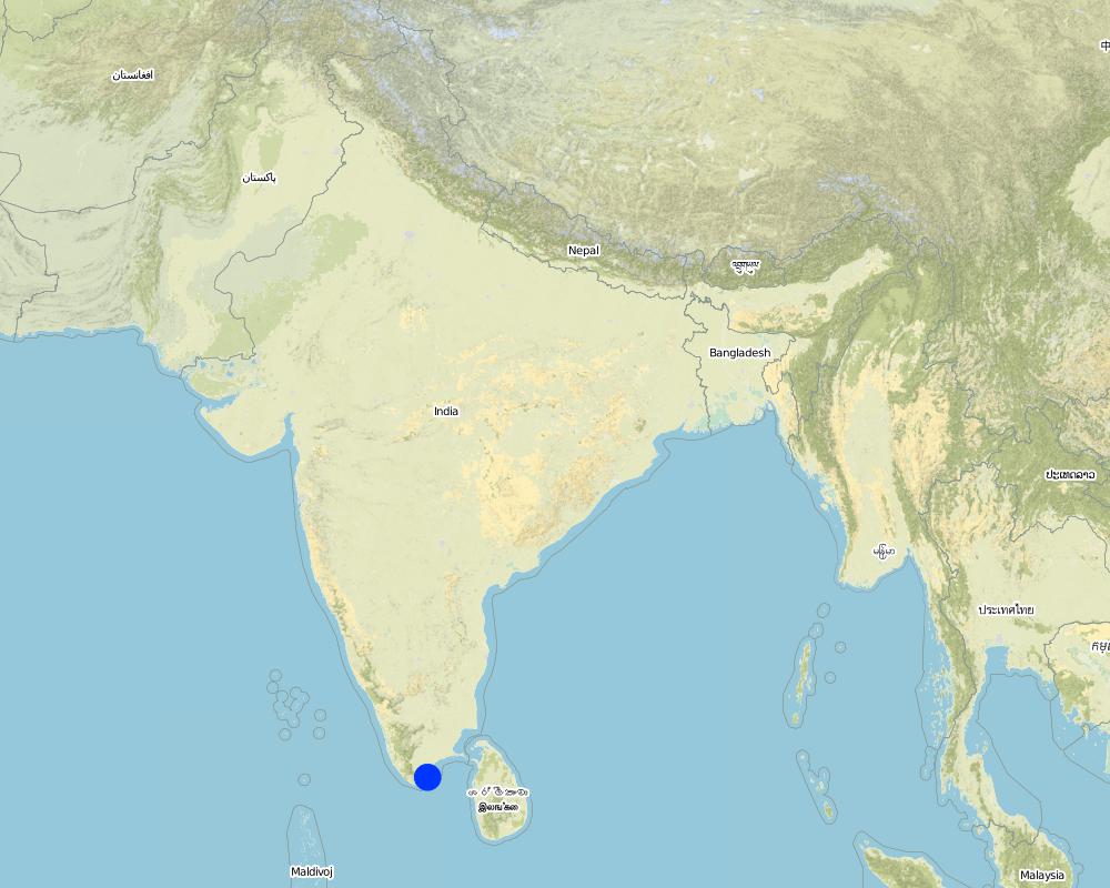
Pays:
Inde
Région/ Etat/ Province:
Tirunelveli district, Tamil nadu state
Commentaires:
Total area covered by the SLM Technology is 100 km2.
The technology was implemented in the sand dune belt locally known as 'theri', located between the western mountain range and east coast of south India. The technology was initially implemented by the Government of Tamil nadu state in 1978 till 1985. The Danida supported project implemented by the department of Agricultural Engineering began activities to strengthen existing shelter belts, introduce inter belts and mass plantation from 1991 till 1999. The technology was initially implemented in an area much wider than the their lands, but experience showed that the shelterbelts was not the best methodology for low wind agricultural areas, so a shift to agro forestry and mass planting occurred.
Map
×2.6 Date de mise en œuvre de la Technologie
Si l'année précise est inconnue, indiquez la date approximative: :
- il y a moins de 10 ans (récemment)
2.7 Introduction de la Technologie
Spécifiez comment la Technologie a été introduite: :
- par le biais de projets/ d'interventions extérieures
Commentaires (type de projet, etc.) :
The Department of Agriculture Engineering implemented shelterbelts since 1958 in neighbouring Madurai district. The technology was introduced to Tirunelveli district by the department in 1978 wherein 5 row shelterbelts were established.
3. Classification de la Technologie de GDT
3.1 Principal(aux) objectif(s) de la Technologie
- améliorer la production
- préserver l'écosystème
3.2 Type(s) actuel(s) d'utilisation des terres, là où la Technologie est appliquée
Les divers types d'utilisation des terres au sein du même unité de terrain: :
Oui
Précisez l'utilisation mixte des terres (cultures/ pâturages/ arbres):
- Agro-sylvo-pastoralisme

Terres cultivées
Nombre de période de croissance par an: :
- 1
Précisez:
Longest growing period in days: 100 Longest growing period from month to month: Oct - Dec

Pâturages

Forêts/ bois
- Plantations d'arbres, boisements
Produits et services:
- Protection contre les aléas naturels
Commentaires:
Major land use problems (compiler’s opinion): Crops cannot be cultivated due to sand deposition. Grass cover cannot develop due to shifting of dunes. Hence the area is neglected and degrades further. Only hardy species (ef. Palymra) and coarse grasses survive. Predominant land use is open grazing.
Major land use problems (land users’ perception): Land cannot be cultivated economically due to arid conditions, shifting dunes and open grazing.
Type of cropping system and major crops comments: Cultivation is practiced only in years of good rainfall. Single crop of pulse (black gram ) is taken.
3.4 Approvisionnement en eau
Approvisionnement en eau des terres sur lesquelles est appliquée la Technologie:
- pluvial
Commentaires:
Water supply: Also mixed rainfed - irrigated (ranked 2)
3.5 Groupe de GDT auquel appartient la Technologie
- brise-vent/ plantations abris
3.7 Principaux types de dégradation des terres traités par la Technologie

érosion éolienne des sols
- Ed: déflation et déposition
- Eo: effets hors site de la dégradation
Commentaires:
Main type of degradation addressed: Eo: offsite degradation effects
Secondary types of degradation addressed: Ed: deflation and deposition
4. Spécifications techniques, activités, intrants et coûts de mise en œuvre
4.1 Dessin technique de la Technologie
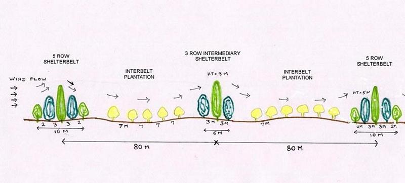
Spécifications techniques (associées au dessin technique):
Technical Drawing - Shelterbelt
Technical knowledge required for field staff / advisors: high
Technical knowledge required for land users: moderate
Main technical functions: reduction in wind speed
Secondary technical functions: improvement of ground cover, arresting movement of sand
Slope (which determines the spacing indicated above): 2.00%
Auteur:
David Gandhi, India
4.2 Informations générales sur le calcul des intrants et des coûts
autre/ monnaie nationale (précisez):
Indian Rupee
Indiquez le taux de change des USD en devise locale, le cas échéant (p.ex. 1 USD = 79.9 réal brésilien): 1 USD = :
48,85
Indiquez le coût salarial moyen de la main d'œuvre par jour:
1.00
4.3 Activités de mise en place/ d'établissement
| Activité | Calendrier des activités (saisonnier) | |
|---|---|---|
| 1. | Nursery raising | May-Nov |
| 2. | Pitting | Oct-Nov |
| 3. | Filling of pits | Nov-Dec at plantation |
| 4. | Life watering | Nov-Dec at plantation |
| 5. | Periodic watering | weekly during 1st year, except monsoon |
| 6. | Provision of shade to saplings | at planting |
4.4 Coûts et intrants nécessaires à la mise en place
Commentaires:
Duration of establishment phase: 60 month(s)
4.5 Activités d'entretien/ récurrentes
| Activité | Calendrier/ fréquence | |
|---|---|---|
| 1. | Watering | 2 & 3rd year after plantation /fortnightly, except monsoon |
| 2. | Casualty replacement | 2nd year /monsoon |
| 3. | Watch & ward | upto 5th year /full time watchman |
4.7 Facteurs les plus importants affectant les coûts
Décrivez les facteurs les plus importants affectant les coûts :
The above costs cover an establishment period of 5 years for 1 hectare (250 plants) of shelterbelt; year 1: pitting, planting, watering. Year 2 & 3: periodic watering, watch and ward, prunng, gap filling. Year 4 & 5: watch and ward, pruning. Of the total number of 391 mandays/ha. of shelterbelt, 288 mandays go towards periodic watering over the first 3 years. Watering of plants is essential due to the semi-arid climate and sandy soil. In addition, as supportive technology for provision of water, one borewell with handpump was established per kilometer of shelterbelt.
5. Environnement naturel et humain
5.1 Climat
Précipitations annuelles
- < 250 mm
- 251-500 mm
- 501-750 mm
- 751-1000 mm
- 1001-1500 mm
- 1501-2000 mm
- 2001-3000 mm
- 3001-4000 mm
- > 4000 mm
Spécifiez la pluviométrie moyenne annuelle (si connue), en mm:
559,00
Spécifications/ commentaires sur les précipitations:
30 years average
Zone agro-climatique
- semi-aride
Since past few years, arid conditions prevail
5.2 Topographie
Pentes moyennes:
- plat (0-2 %)
- faible (3-5%)
- modéré (6-10%)
- onduleux (11-15%)
- vallonné (16-30%)
- raide (31-60%)
- très raide (>60%)
Reliefs:
- plateaux/ plaines
- crêtes
- flancs/ pentes de montagne
- flancs/ pentes de colline
- piémonts/ glacis (bas de pente)
- fonds de vallée/bas-fonds
Zones altitudinales:
- 0-100 m
- 101-500 m
- 501-1000 m
- 1001-1500 m
- 1501-2000 m
- 2001-2500 m
- 2501-3000 m
- 3001-4000 m
- > 4000 m
Commentaires et précisions supplémentaires sur la topographie:
Landforms: Plateau/plains (undulating terrain)
Slopes on average: Gentle (undulating)
5.3 Sols
Profondeur moyenne du sol:
- très superficiel (0-20 cm)
- superficiel (21-50 cm)
- modérément profond (51-80 cm)
- profond (81-120 cm)
- très profond (>120 cm)
Texture du sol (de la couche arable):
- grossier/ léger (sablonneux)
Matière organique de la couche arable:
- faible (<1%)
Si disponible, joignez une description complète du sol ou précisez les informations disponibles, par ex., type de sol, pH/ acidité du sol, capacité d'échange cationique, azote, salinité, etc.
Soil depth on average: Very deep (due to deposition by wind)
Soil texture: Coarse/light (sandy soil),
Soil fertility: Very low (low organic matter)
Topsoil organic matter: Low (low vegetative cover)
Soil drainage/infiltration: Good (permeability is high)
Soil water storage capacity: Very low (sandy soil, low organic matter)
5.6 Caractéristiques des exploitants des terres appliquant la Technologie
Revenus hors exploitation:
- > 50% de tous les revenus
Niveau relatif de richesse:
- pauvre
- moyen
Niveau de mécanisation:
- travail manuel
Indiquez toute autre caractéristique pertinente des exploitants des terres:
Population density: 50-100 persons/km2
Annual population growth: 1% - 2%
38% of the land users are average wealthy (traders, labor).
42% of the land users are poor (small farmers, without water source).
20% of the land users are poor (small farmers, without water source).
Off-farm income specification: traders, employed in cashew processing plants, small industries, nearby towns, migration.
Level of mechanization: Manual work (in addition bullocks are used for ploughing)
5.8 Propriété foncière, droits d’utilisation des terres et de l'eau
Propriété foncière:
- individu, avec titre de propriété
Droits d’utilisation des terres:
- accès libre (non organisé)
6. Impacts et conclusions
6.4 Analyse coûts-bénéfices
Quels sont les bénéfices comparativement aux coûts de mise en place (du point de vue des exploitants des terres)?
Rentabilité à court terme:
très négative
Rentabilité à long terme:
positive
Quels sont les bénéfices comparativement aux coûts d'entretien récurrents (du point de vue des exploitants des terres)?
Rentabilité à court terme:
légèrement négative
Rentabilité à long terme:
très positive
6.5 Adoption de la Technologie
De tous ceux qui ont adopté la Technologie, combien d'entre eux l'ont fait spontanément, à savoir sans recevoir aucune incitation matérielle, ou aucune rémunération? :
- 0-10%
Commentaires:
100% of land user families have adopted the Technology with external material support
5000 land user families have adopted the Technology with external material support
Comments on acceptance with external material support: estimates
There is a little trend towards spontaneous adoption of the Technology
Comments on adoption trend: Farmers are in favour of raising orchards to combat wind erosion and increase production in place of shelterbelts..
7. Références et liens
7.1 Méthodes/ sources d'information
7.2 Références des publications disponibles
Titre, auteur, année, ISBN:
Review Reports
Disponible à partir d'où? Coût?
Chief Engineer, Agriculture Engineering Department, Anna Salai-439, Nandanam, Chennai-600035
Titre, auteur, année, ISBN:
Project Implementation Plans, Project documents
Disponible à partir d'où? Coût?
Programme Coordinator, WDCU, 11/1 Sarvapriya Vihar, New Delhi-110016.
Liens et modules
Développer tout Réduire toutLiens
Aucun lien
Modules
Aucun module trouvé