Shelterbelts [ອິນເດຍ]
- ການສ້າງ:
- ປັບປູງ:
- ຜູ້ສັງລວມຂໍ້ມູນ: Unknown User
- ບັນນາທິການ: –
- ຜູ້ທົບທວນຄືນ: Fabian Ottiger, Alexandra Gavilano
Line, Shelterbelts in Theri land
technologies_1473 - ອິນເດຍ
ເບິ່ງພາກສ່ວນ
ຂະຫຍາຍທັງໝົດ ຍຸບທັງໝົດ1. ຂໍ້ມູນທົ່ວໄປ
1.3 ເງື່ອນໄຂ ກ່ຽວກັບ ການນໍາໃຊ້ຂໍ້ມູນເອກະສານ ທີ່ສ້າງຂື້ນ ໂດຍຜ່ານ ອົງການພາບລວມຂອງໂລກ ທາງດ້ານແນວທາງ ແລະ ເຕັກໂນໂລຢີ ຂອງການອານຸລັກ ທໍາມະຊາດ (WOCAT)
ຜູ້ປ້ອນຂໍ້ມູນ ແລະ ບຸກຄົນສຳຄັນ ທີ່ໃຫ້ຂໍ້ມູນ (ຫຼາຍ) ຍິນຍອມ ຕາມເງື່ອນໄຂ ໃນການນຳໃຊ້ຂໍ້ມູນ ເພື່ອສ້າງເປັນເອກກະສານຂອງ WOCAT:
ແມ່ນ
2. ການອະທິບາຍ ເຕັກໂນໂລຢີ ຂອງການຄຸ້ມຄອງ ທີ່ດິນແບບຍືນຍົງ
2.1 ຄໍາອະທິບາຍສັ້ນຂອງ ເຕັກໂນໂລຢີ
ການກຳໜົດຄວາມໝາຍ ຂອງເຕັກໂນໂລຢີ:
Cultivation of tree belts across the direction of wind at appropriate intervals in the deposition zone, with a view to arrest wind erosion and facilitate stabilisation of dunes through interbelt development.
2.2 ການອະທິບາຍ ລາຍລະອຽດ ຂອງເຕັກໂນໂລຢີ
ການພັນລະນາ:
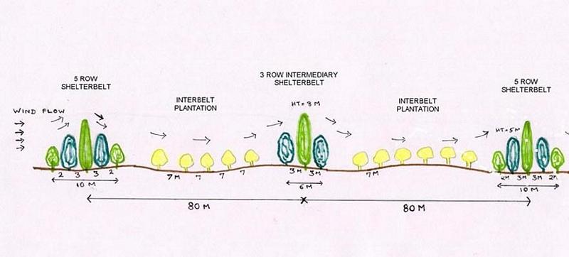
The technology comprises establishment of 5 row shelterbelts at 160 m intervals. 3 row intermediary shelterbelts are introduced in between existing shelterbelts at 80 m interval. Land owners are encouraged to cultivate tree crops in between the belts.
Purpose of the Technology: Shelterbelts are useful in reducing wind velocity, there by arresting shifting of sand dunes, deposition of sand on fields, habitation, wells, roads etc. Cultivation of area between tree belts is made possible leading to increase in productivity from these lands.
Establishment / maintenance activities and inputs: The shelterbelts comprise tree species of different heights planted in rows (5 and 3 row deep) in a straight line across the wind direction. Six month old seedlings are planted in pits of volume 1 cuft to 1.5 cuft, which are filled with tank silt. One borewell is provided for one km length for life saving irrigation.
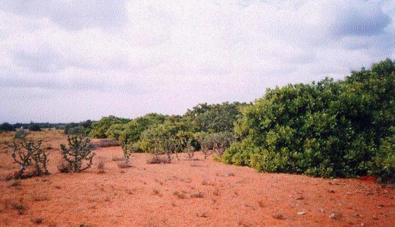
Natural / human environment: The environment is arid and forms the deposition zone wherein sand lifted from the impact zone is deposited. Sand dunes cover the area.
2.3 ຮູບພາບຂອງເຕັກໂນໂລຢີ
ສື່ຮູບພາບ
2.5 ປະເທດ / ເຂດ / ສະຖານທີ່ບ່ອນທີ່ ເຕັກໂນໂລຢີ ໄດ້ຮັບການນໍາໃຊ້ ແລະ ທີ່ຖືກປົກຄຸມດ້ວຍການປະເມີນຜົນ
ປະເທດ:
ອິນເດຍ
ພາກພື້ນ / ລັດ / ແຂວງ:
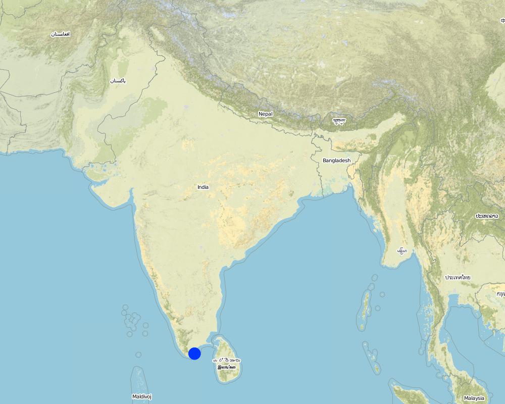
Tirunelveli district, Tamil nadu state
ຄວາມຄິດເຫັນ:
Total area covered by the SLM Technology is 100 km2.
The technology was implemented in the sand dune belt locally known as 'theri', located between the western mountain range and east coast of south India. The technology was initially implemented by the Government of Tamil nadu state in 1978 till 1985. The Danida supported project implemented by the department of Agricultural Engineering began activities to strengthen existing shelter belts, introduce inter belts and mass plantation from 1991 till 1999. The technology was initially implemented in an area much wider than the their lands, but experience showed that the shelterbelts was not the best methodology for low wind agricultural areas, so a shift to agro forestry and mass planting occurred.
Map
×2.6 ວັນທີໃນການຈັດຕັ້ງປະຕິບັດ
ຖ້າຫາກວ່າ ບໍ່ຮູ້ຈັກ ປີທີ່ຊັດເຈນ ແມ່ນໃຫ້ປະມານ ວັນທີເອົາ:
- ຕໍ່າກວ່າ 10 ປີ ຜ່ານມາ (ມາເຖິງປະຈຸບັນ)
2.7 ການນໍາສະເໜີ ເຕັກໂນໂລຢີ
ໃຫ້ລະບຸ ເຕັກໂນໂລຢີ ໄດ້ຖືກຈັດຕັ້ງປະຕິບັດຄືແນວໃດ?
- ໂດຍຜ່ານໂຄງການ / ການຊ່ວຍເຫຼືອຈາກພາຍນອກ
ຄວາມຄິດເຫັນ (ປະເພດ ໂຄງການ ແລະ ອື່ນໆ):
The Department of Agriculture Engineering implemented shelterbelts since 1958 in neighbouring Madurai district. The technology was introduced to Tirunelveli district by the department in 1978 wherein 5 row shelterbelts were established.
3. ການໃຈ້ແຍກ ເຕັກໂນໂລຢີ ໃນການຄຸ້ມຄອງ ດິນແບບຍືນຍົງ
3.1 ຈຸດປະສົງຫຼັກ (ຫຼາຍ) ຂອງເຕັກໂນໂລຢີ
- ປັບປຸງ ການຜະລິດ
- ການອະນຸລັກ ລະບົບນິເວດ
3.2 ປະເພດການນໍາໃຊ້ທີ່ດິນ ໃນປະຈຸບັນ() ທີ່ເຕັກໂນໂລຢີ ໄດ້ຖືກນໍາໃຊ້
ການນຳໃຊ້ທີ່ດິນ ປະສົມພາຍໃນພື້ນທີ່ດຽວກັນ:
ແມ່ນ
ລະບຸການນຳໃຊ້ທີ່ດິນແບບປະສົມ (ຜົນລະປູກ / ທົ່ງຫຍ້າລ້ຽງສັດ / ຕົ້ນໄມ້):
- ປ່າໄມ້-ທົ່ງຫຍ້າ

ດິນທີ່ປູກພືດ
ຈໍານວນ ລະດູການ ປູກໃນປີໜຶ່ງ:
- 1
ລະບຸ ຊະນິດ:
Longest growing period in days: 100 Longest growing period from month to month: Oct - Dec

ທົ່ງຫຍ້າລ້ຽງສັດ

ປ່າໄມ້ / ປ່າ
- ການປູກຕົ້ນໄມ້, ການປູກປ່າ
ຜົນຜະລິດ ແລະ ການບໍລິການ:
- ປ້ອງກັນ ການຄຸກຄາມ ທາງທໍາມະຊາດ
ຄວາມຄິດເຫັນ:
Major land use problems (compiler’s opinion): Crops cannot be cultivated due to sand deposition. Grass cover cannot develop due to shifting of dunes. Hence the area is neglected and degrades further. Only hardy species (ef. Palymra) and coarse grasses survive. Predominant land use is open grazing.
Major land use problems (land users’ perception): Land cannot be cultivated economically due to arid conditions, shifting dunes and open grazing.
Type of cropping system and major crops comments: Cultivation is practiced only in years of good rainfall. Single crop of pulse (black gram ) is taken.
3.4 ການສະໜອງນ້ຳ
ການສະໜອງນໍ້າ ໃນພື້ນທີ່ ທີ່ໄດ້ນໍາໃຊ້ ເຕັກໂນໂລຢີ:
- ນໍ້າຝົນ
ຄວາມຄິດເຫັນ:
Water supply: Also mixed rainfed - irrigated (ranked 2)
3.5 ການນໍາໃຊ້ເຕັກໂນໂລຢີ ທີ່ຢູ່ໃນກຸ່ມການຄຸ້ມຄອງ ທີ່ດິນແບບຍືນຍົງ
- ແລວກັນລົມ / ພາຍຸ
3.7 ປະເພດດິນເຊື່ອມໂຊມ ຫຼັກທີ່ໄດ້ນໍາໃຊ້ ເຕັກໂນໂລຢີ

ດິນເຊາະເຈື່ອນ ໂດຍລົມ
- Ed: ການສູນເສຍຈາກລົມ ແລະ ການທັບຖົມ
- Eo: ຜົນກະທົບຈາກການເຊື່ອມໂຊມທາງອ້ອມ
ຄວາມຄິດເຫັນ:
Main type of degradation addressed: Eo: offsite degradation effects
Secondary types of degradation addressed: Ed: deflation and deposition
4. ຂໍ້ກໍາໜົດ, ກິດຈະກໍາການປະຕິບັດ, ວັດຖຸດິບ, ແລະຄ່າໃຊ້ຈ່າຍ
4.1 ເຕັກນິກ ໃນການແຕ້ມແຜນວາດ ເຕັກໂນໂລຢີ
ຄຸນລັກສະນະ ຂອງເຕັກນິກ (ທີ່ກ່ຽວຂ້ອງ ກັບການແຕ້ມແຜນວາດ ທາງດ້ານເຕັກນີກ):
Technical Drawing - Shelterbelt
Technical knowledge required for field staff / advisors: high
Technical knowledge required for land users: moderate
Main technical functions: reduction in wind speed
Secondary technical functions: improvement of ground cover, arresting movement of sand
Slope (which determines the spacing indicated above): 2.00%
ຜູ້ຂຽນ:
David Gandhi, India
4.2 ຂໍ້ມູນທົ່ວໄປກ່ຽວກັບການຄິດໄລ່ປັດໃຈຂາເຂົ້າໃນການຜະລິດ ແລະ ມູນຄ່າອື່ນໆ
ສະກຸນເງິນອື່ນໆ / ປະເທດອື່ນໆ (ລະບຸ):
Indian Rupee
ຖ້າກ່ຽວຂ້ອງ, ໃຫ້ລະບຸອັດຕາແລກປ່ຽນຈາກ USD ເປັນສະກຸນເງິນທ້ອງຖິ່ນ (ເຊັ່ນ: 1 USD = 79.9 Brazilian Real): 1 USD =:
48.85
ລະບຸ ຄ່າຈ້າງ ຄ່າແຮງງານສະເລ່ຍ ຕໍ່ ວັນ:
1.00
4.3 ການສ້າງຕັ້ງກິດຈະກໍາ
| ກິດຈະກໍາ | Timing (season) | |
|---|---|---|
| 1. | Nursery raising | May-Nov |
| 2. | Pitting | Oct-Nov |
| 3. | Filling of pits | Nov-Dec at plantation |
| 4. | Life watering | Nov-Dec at plantation |
| 5. | Periodic watering | weekly during 1st year, except monsoon |
| 6. | Provision of shade to saplings | at planting |
4.4 ຕົ້ນທຶນ ແລະ ປັດໄຈຂາເຂົ້າທີ່ຈໍາເປັນໃນຈັດຕັ້ງປະຕິບັດ
ຄວາມຄິດເຫັນ:
Duration of establishment phase: 60 month(s)
4.5 ບໍາລຸງຮັກສາ / ແຜນຈັດຕັ້ງປະຕິບັດ ກິດຈະກໍາ
| ກິດຈະກໍາ | ໄລຍະເວລາ / ຄວາມຖີ່ | |
|---|---|---|
| 1. | Watering | 2 & 3rd year after plantation /fortnightly, except monsoon |
| 2. | Casualty replacement | 2nd year /monsoon |
| 3. | Watch & ward | upto 5th year /full time watchman |
4.7 ປັດໄຈ ທີ່ສໍາຄັນ ທີ່ສົ່ງຜົນກະທົບ ຕໍ່ຄ່າໃຊ້ຈ່າຍ
ໃຫ້ອະທິບາຍ ປັດໃຈ ທີ່ສົ່ງຜົນກະທົບ ຕໍ່ຕົ້ນທຶນ ໃນການຈັດຕັ້ງປະຕິບັດ:
The above costs cover an establishment period of 5 years for 1 hectare (250 plants) of shelterbelt; year 1: pitting, planting, watering. Year 2 & 3: periodic watering, watch and ward, prunng, gap filling. Year 4 & 5: watch and ward, pruning. Of the total number of 391 mandays/ha. of shelterbelt, 288 mandays go towards periodic watering over the first 3 years. Watering of plants is essential due to the semi-arid climate and sandy soil. In addition, as supportive technology for provision of water, one borewell with handpump was established per kilometer of shelterbelt.
5. ສະພາບແວດລ້ອມທໍາມະຊາດ ແລະ ມະນຸດ
5.1 ອາກາດ
ປະລິມານນໍ້າຝົນປະຈໍາປີ
- < 250 ມີລິແມັດ
- 251-500 ມີລິແມັດ
- 501-750 ມີລິແມັດ
- 751-1,000 ມີລິແມັດ
- 1,001-1,500 ມີລິແມັດ
- 1,501-2,000 ມີລິແມັດ
- 2,001-3,000 ມີລິແມັດ
- 3,001-4,000 ມີລິແມັດ
- > 4,000 ມີລິແມັດ
ໃຫ້ລະບຸສະເລ່ຍ ປະລິມານນໍ້າຝົນຕົກປະຈໍາປີ ເປັນມິນລິແມັດ (ຖ້າຫາກຮູ້ຈັກ):
559.00
ຂໍ້ມູນສະເພາະ / ຄວາມເຫັນກ່ຽວກັບ ປະລິມານນໍ້າຝົນ:
30 years average
ເຂດສະພາບອາກາດກະສິກໍາ
- ເຄິ່ງແຫ້ງແລ້ງ
Since past few years, arid conditions prevail
5.2 ພູມິປະເທດ
ຄ່າສະເລ່ຍ ຄວາມຄ້ອຍຊັນ:
- ພື້ນທີ່ຮາບພຽງ (0-2%)
- ອ່ອນ (3-5 %)
- ປານກາງ (6-10 %)
- ມ້ວນ (11-15 %)
- ເນີນ(16-30%)
- ໍຊັນ (31-60%)
- ຊັນຫຼາຍ (>60%)
ຮູບແບບຂອງດິນ:
- ພູພຽງ / ທົ່ງພຽງ
- ສັນພູ
- ເປີ້ນພູ
- ເນີນພູ
- ຕີນພູ
- ຮ່ອມພູ
ເຂດລະດັບສູງ:
- 0-100 ແມັດ a.s.l.
- 101-500 ແມັດ a.s.l.
- 501-1,000 ແມັດ a.s.l.
- 1,001-1,500 ແມັດ a.s.l.
- 1,501-2,000 ແມັດ a.s.l.
- 2,001-2,500 ແມັດ a.s.l.
- 2,501-3,000 ແມັດ a.s.l.
- 3,001-4,000 ແມັດ a.s.l.
- > 4,000 ແມັດ a.s.l.
ຄຳເຫັນ ແລະ ຂໍ້ມູນສະເພາະ ເພີ່ມເຕີມ ກ່ຽວກັບ ພູມີປະເທດ:
Landforms: Plateau/plains (undulating terrain)
Slopes on average: Gentle (undulating)
5.3 ດິນ
ຄວາມເລິກ ຂອງດິນສະເລ່ຍ:
- ຕື້ນຫຼາຍ (0-20 ຊັງຕີແມັດ)
- ຕື້ນ (21-50 ຊຕມ)
- ເລີກປານກາງ (51-80 ຊຕມ)
- ເລິກ (81-120 ຊມ)
- ເລິກຫຼາຍ (> 120 cm)
ເນື້ອດິນ (ໜ້າດິນ):
- ຫຍາບ / ເບົາ (ດິນຊາຍ)
ຊັ້ນອິນຊີວັດຖຸ ເທິງໜ້າດິນ:
- ຕໍາ່ (<1 %)
ຖ້າເປັນໄປໄດ້ ແມ່ນໃຫ້ຕິດຄັດ ການພັນລະນາດິນ ຫຼື ຂໍ້ມູນສະເພາະຂອງດິນ, ຕົວຢ່າງ, ຄຸນລັກສະນະ ປະເພດຂອງດິນ, ຄ່າຄວາມເປັນກົດ / ເປັນດ່າງຂອງດິນ, ສານອາຫານ, ດິນເຄັມ ແລະ ອື່ນໆ.
Soil depth on average: Very deep (due to deposition by wind)
Soil texture: Coarse/light (sandy soil),
Soil fertility: Very low (low organic matter)
Topsoil organic matter: Low (low vegetative cover)
Soil drainage/infiltration: Good (permeability is high)
Soil water storage capacity: Very low (sandy soil, low organic matter)
5.6 ຄຸນລັກສະນະ ຂອງຜູ້ນໍາໃຊ້ທີ່ດິນ ທີ່ໄດ້ນໍາໃຊ້ເຕັກໂນໂລຢີ
ລາຍຮັບ ທີ່ບໍ່ໄດ້ມາຈາກ ການຜະລິດ ກະສິກໍາ:
- > 50 % ຂອງລາຍຮັບທັງໝົດ
ລະດັບຄວາມຮັ່ງມີ:
- ທຸກຍາກ
- ສະເລ່ຍ
ລະດັບ ການຫັນເປັນກົນຈັກ:
- ການໃຊ້ແຮງງານຄົນ
ໃຫ້ລະບຸ ຄຸນລັກສະນະ ຂອງຜູ້ນໍາໃຊ້ທີ່ດິນ:
Population density: 50-100 persons/km2
Annual population growth: 1% - 2%
38% of the land users are average wealthy (traders, labor).
42% of the land users are poor (small farmers, without water source).
20% of the land users are poor (small farmers, without water source).
Off-farm income specification: traders, employed in cashew processing plants, small industries, nearby towns, migration.
Level of mechanization: Manual work (in addition bullocks are used for ploughing)
5.8 ເຈົ້າຂອງທີ່ດິນ, ສິດໃຊ້ທີ່ດິນ, ແລະ ສິດທິການນໍາໃຊ້ນໍ້າ
ເຈົ້າຂອງດິນ:
- ບຸກຄົນ, ທີ່ມີຕໍາແໜ່ງ
ສິດທິ ໃນການນໍາໃຊ້ທີ່ດິນ:
- ເປີດກວ້າງ (ບໍ່ມີການຈັດຕັ້ງ)
6. ຜົນກະທົບ ແລະ ລາຍງານສະຫຼຸບ
6.4 ການວິເຄາະຕົ້ນທຶນ ແລະ ຜົນປະໂຫຍດ
ຈະເຮັດປະໂຫຍດເພື່ອປຽບທຽບກັບຄ່າໃຊ້ຈ່າຍກັບສິ່ງກໍ່ສ້າງ (ຈາກທັດສະນະຂອງຜູ້ນຳໃຊ້ທີ່ດິນ) ໄດ້ແນວໃດ?
ຜົນຕອບແທນ ໃນໄລຍະສັ້ນ:
ຜົນກະທົບທາງລົບຫຼາຍ
ຜົນຕອບແທນ ໃນໄລຍະຍາວ:
ຜົນກະທົບທາງບວກ
ຈະໄດ້ຮັບຜົນປະໂຫຍດເມື່ອປຽບທຽບກັບ / ຄ່າໃຊ້ຈ່າຍໃນການບຳລຸງຮັກສາທີເ່ກີດຂື້ນອິກ (ຈາກທັດສະນະຄະຕິຂອງຜູ້ນຳໃຊ້ທີ່ດິນ) ໄດ້ແນວໃດ?
ຜົນຕອບແທນ ໃນໄລຍະສັ້ນ:
ຜົນກະທົບທາງລົບເລັກນ້ອຍ
ຜົນຕອບແທນ ໃນໄລຍະຍາວ:
ຜົນກະທົບທາງບວກຫຼາຍ
6.5 ການປັບຕົວຮັບເອົາເຕັກໂນໂລຢີ
ທັງໝົດນັ້ນ ແມ່ນໃຜ ໄດ້ປັບຕົວເຂົ້າ ໃນການນໍາໃຊ້ ເຕັກໂນໂລຢີ, ມີຈັກຄົນ ທີ່ສາມາດເຮັດເອງໄດ້, ຕົວຢ່າງ, ປາດສະຈາກ ການຊ່ວຍເຫຼືອ ທາງດ້ານອຸປະກອນ / ການຈ່າຍເປັນເງິນ?
- 0-10%
ຄວາມຄິດເຫັນ:
100% of land user families have adopted the Technology with external material support
5000 land user families have adopted the Technology with external material support
Comments on acceptance with external material support: estimates
There is a little trend towards spontaneous adoption of the Technology
Comments on adoption trend: Farmers are in favour of raising orchards to combat wind erosion and increase production in place of shelterbelts..
7. ເອກະສານອ້າງອີງ ແລະ ການເຊື່ອມຕໍ່
7.1 ວິທີການ / ແຫຼ່ງຂໍ້ມູນ
7.2 ເອກກະສານອ້າງອີງທີ່ເປັນບົດລາຍງານ
ຫົວຂໍ້, ຜູ້ຂຽນ, ປີ, ISBN:
Review Reports
ມີຢູ່ໃສ?ມູນຄ່າເທົ່າໃດ?
Chief Engineer, Agriculture Engineering Department, Anna Salai-439, Nandanam, Chennai-600035
ຫົວຂໍ້, ຜູ້ຂຽນ, ປີ, ISBN:
Project Implementation Plans, Project documents
ມີຢູ່ໃສ?ມູນຄ່າເທົ່າໃດ?
Programme Coordinator, WDCU, 11/1 Sarvapriya Vihar, New Delhi-110016.
ຂໍ້ມູນການເຊື່ອມຕໍ່ ແລະ ເນື້ອໃນ
ຂະຫຍາຍທັງໝົດ ຍຸບທັງໝົດການເຊື່ອມຕໍ່
ບໍ່ມີຂໍ້ມູນການເຊື່ອມຕໍ່
ເນື້ອໃນ
ບໍ່ມີເນື້ອໃນ