Rehabilitation of degraded communal grazing land [Nepal]
- Criação:
- Atualização:
- Compilador/a: Nicole Guedel
- Editor: –
- Revisores: David Streiff, Alexandra Gavilano
Kshetigrasta samudayik charan bhumi ko punaruththan (Nepali)
technologies_1492 - Nepal
Veja as seções
Expandir tudo Recolher tudo1. Informação geral
1.2 Detalhes do contato das pessoas capacitadas e instituições envolvidas na avaliação e documentação da tecnologia
Especialista em GST:
Especialista em GST:
Nome do projeto que facilitou a documentação/avaliação da Tecnologia (se relevante)
People and Resource Dynamics Project, Nepal (PARDYP)Nome da(s) instituição(ões) que facilitou(ram) a documentação/ avaliação da Tecnologia (se relevante)
ICIMOD International Centre for Integrated Mountain Development (ICIMOD) - Nepal1.3 Condições em relação ao uso da informação documentada através de WOCAT
O/a compilador/a e a(s) pessoa(s) capacitada(s) aceitam as condições relativas ao uso de dados documentados através da WOCAT:
Sim
2. Descrição da tecnologia de GST
2.1 Descrição curta da tecnologia
Definição da tecnologia:
Rehabilitation measures, including eyebrow pits and live fencing, were implemented on degraded communal grazing land to reestablish a protective vegetative cover
2.2 Descrição detalhada da tecnologia
Descrição:
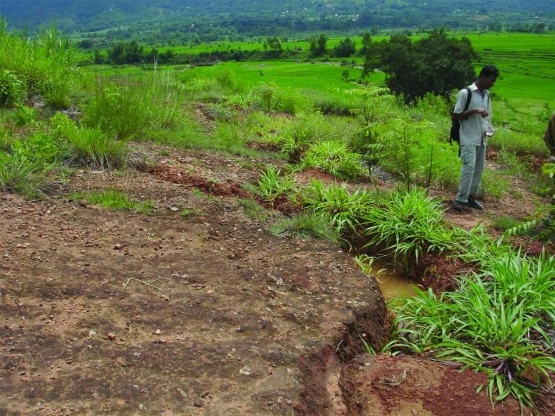
An area of heavily degraded grazing land was rehabilitated by establishing eyebrow pits to control and harvest runoff, planting trees and grasses, and fencing the site to control grazing. The main purpose was to re-establish vegetative cover on the almost bare, overgrazed site. The site is community land of the 40 households (240 people) of Dhotra village in the Jhikhu Khola watershed. These people are very dependent on this area due to the lack of alternative grazing sites. The rehabilitation site is surrounded by irrigated cropland downstream, grazing land, and degraded sal (Shorea robusta) dominated forest. Rainfed forward-sloping terraces immediately adjoin the site.
About 130 eyebrow pits were dug, together with catch drainage trenches. Several species of grass and fodder were planted along the ridges of the eyebrows and drainage trenches. Contour hedgerows were established between the eyebrow pits and trenches, and trees were planted just below the pits. The maintenance is quite easy: the vegetation needs to be cut back from time to time and the pits cleaned before the pre-monsoon period. The remaining bare areas should be revisited each year and replanted.
The area has a distinct dry season from November to May and a wet monsoon period from June to October. Annual rainfall is around 1200 mm. The site has red soils that are highly weathered and, if not properly managed, are very susceptible to erosion.
2.3 Fotos da tecnologia
Galeria de Mídias
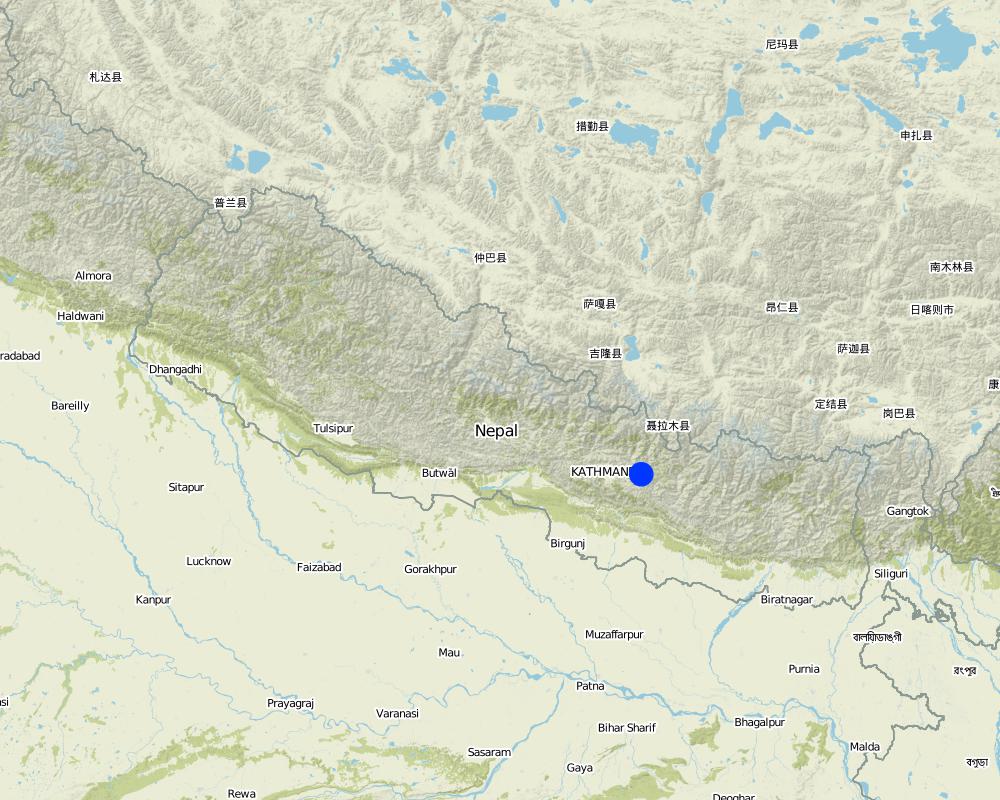
2.5 País/região/locais onde a tecnologia foi aplicada e que estão cobertos nesta avaliação
País:
Nepal
Região/Estado/Província:
Kavre Palanchok/ Dhotra village, Jhikhu Khola watershed
Especifique a difusão da tecnologia:
- Uniformemente difundida numa área
Se a Tecnologia estiver uniformemente distribuída por uma área, especifique a área coberta (em km2):
0,019
Se a área precisa não for conhecida, indicar a área aproximada coberta:
- < 0,1 km2 (10 ha)
Comentários:
Total area covered by the SLM Technology is 0.019 km2.
Map
×2.6 Data da implementação
Caso o ano exato seja desconhecido, indique a data aproximada:
- menos de 10 anos atrás (recentemente)
2.7 Introdução da tecnologia
Especifique como a tecnologia foi introduzida:
- através de projetos/intervenções externas
Comentários (tipos de projeto, etc.):
The hedgerow technology came from the Philliphines, modified from the SALT (Sloping agriculture land technology) technology. The eye brow pit technology was implemented by the Department of Soil Conservation and Watershed Management in Nepal and was adapted from them. Villagers approached the People and Resource Dynamics Project (PARDYP) for advice. PARDYP assisted, based on experiences made before with rehabilitation experiments under similar conditions. Mainly developed according to theoretical and site specific knowledge.
3. Classificação da tecnologia de GST
3.1 Principal/principais finalidade(s) da tecnologia
- Reduz, previne, recupera a degradação do solo
3.2 Tipo(s) atualizado(s) de uso da terra onde a tecnologia foi aplicada

Pastagem
Pastagem extensiva:
- Fazenda pecuária
Comentários:
Major land use problems (compiler’s opinion): The major land use problem is the small per capita landholding size for cropping. These holdings are mostly rainfed, have a low soil fertility status and acidity problems, and are susceptible to erosion. Intense rainfall at the beginning of the rainy season causes considerable soil loss (rill and gully erosion).
Major land use problems (land users’ perception): Overgrazing leading to lack of vegetation.
Ranching: Yes
Future (final) land use (after implementation of SLM Technology): Forests / woodlands: Fp: Plantations, afforestations
Number of growing seasons per year: 3
Longest growing period in days: 150; Longest growing period from month to month: Jun - Oct; Second longest growing period in days: 120; Second longest growing period from month to month: Nov - Feb
3.3 O uso do solo mudou devido à implementação da Tecnologia?
O uso do solo mudou devido à implementação da Tecnologia?
- Sim (Por favor, preencha as perguntas abaixo com relação ao uso do solo antes da implementação da Tecnologia)
Pastagem
- Extensive grazing
3.4 Abastecimento de água
Abastecimento de água para a terra na qual a tecnologia é aplicada:
- Precipitação natural
3.5 Grupo de GST ao qual pertence a tecnologia
- Solo/cobertura vegetal melhorada
- Desvio e drenagem de água
3.6 Medidas de GST contendo a tecnologia

Medidas vegetativas
- V1: cobertura de árvores/arbustos

Medidas estruturais
- S4: Valas de nível, fossos

Medidas de gestão
- M5: Controle/mudança de composição de espécies
Comentários:
Main measures: vegetative measures, structural measures
Secondary measures: management measures
Type of vegetative measures: aligned: -contour, in blocks
3.7 Principais tipos de degradação da terra abordados pela tecnologia

Erosão do solo pela água
- Wt: Perda do solo superficial/erosão de superfície

Deteriorização física do solo
- Pc: Compactação
Comentários:
Main type of degradation addressed: Wt: loss of topsoil / surface erosion
Secondary types of degradation addressed: Pc: compaction
Main causes of degradation: overgrazing (insufficient forage supply from the private land.), education, access to knowledge and support services (identification of appropriate SWC technologies and appropriate collaborators)
Secondary causes of degradation: deforestation / removal of natural vegetation (incl. forest fires) (for daily household needs ( litter , firewood, timber), other natural causes (avalanches, volcanic eruptions, mud flows, highly susceptible natural resources, extreme topography, etc.) specify (excessive rainfall during pre-monsoon and monsoon), poverty / wealth (to buy planting materials and for logistics), labour availability (for community level social work)
3.8 Redução, prevenção ou recuperação da degradação do solo
Especifique o objetivo da tecnologia em relação a degradação da terra:
- Recuperar/reabilitar solo severamente degradado
4. Especificações técnicas, implementação de atividades, entradas e custos
4.1 Desenho técnico da tecnologia
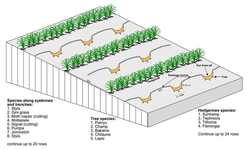
Especificações técnicas (relacionada ao desenho técnico):
Technical drawing of layout of vegetative and structural measures.
Location: "Dhotra" village, near Dhulikhel. Kabhre Palanchok district
Date: July 2004
Technical knowledge required for field staff / advisors: low
Technical knowledge required for land users: low
Main technical functions: improvement of ground cover, increase / maintain water stored in soil, water harvesting / increase water supply
Secondary technical functions: reduction of slope angle, reduction of slope length, increase in organic matter
Aligned: -contour
Vegetative material: G : grass
Spacing between rows / strips / blocks (m): 6 m
In blocks
Vegetative material: T : trees / shrubs
Number of plants per (ha): 120
Spacing between rows / strips / blocks (m): 6 m
Vertical interval within rows / strips / blocks (m): 4 m
Trees/ shrubs species: Prunus cerasoides, Michelia champaca, Melia azedarach, Schima wallichii,Cherospondias axillaries
Grass species: Stylosanthes guianensis, Panicum maximum, Pennisetum purpureum, Melinis minutiflora, Brachiaria decu
Slope (which determines the spacing indicated above): 20.00%
Gradient along the rows / strips: 2.00%
Wall/ barrier
Spacing between structures (m): 5-10 m
Height of bunds/banks/others (m): 1-2 m
Width of bunds/banks/others (m): 1 m
Length of bunds/banks/others (m): 1.5-4 m
Bund/ bank: semi-circular/V shaped trapezoidal
Spacing between structures (m): 6 m
Depth of ditches/pits/dams (m): 40-50 cm
Width of ditches/pits/dams (m): 1-1.5m
Length of ditches/pits/dams (m): 2-2.5 m
Height of bunds/banks/others (m): 10-30
Width of bunds/banks/others (m): 1-1.5 m
Length of bunds/banks/others (m): 1-2 m
Structural measure: diversion ditch / cut-off drain
Spacing between structures (m): 6 m
Depth of ditches/pits/dams (m): 0-30 cm
Width of ditches/pits/dams (m): 10-30 cm
Construction material (earth): soil resulting from the digging activities were used to construct eyebrow shaped bunds.
Slope (which determines the spacing indicated above): 20%
Lateral gradient along the structure: 2%
Vegetation is used for stabilisation of structures.
Other type of management: closing for change of management / intensity level - grazing as well as "symbolic" fencing by small living fence to delineate SWC area.
Autor:
A.K. Thaku, Madhav Dhakal
4.2 Informação geral em relação ao cálculo de entradas e custos
Especifique a moeda utilizada para os cálculos de custo:
- USD
Indique a média salarial da mão-de-obra contratada por dia:
2.00
4.3 Atividades de implantação
| Atividade | Periodicidade (estação do ano) | |
|---|---|---|
| 1. | Planting of tree seedlings and cuttings and sowing of grass seeds. | before onset of monsoon (June) |
| 2. | Drawing layout of eyebrow terraces, drainage ditches, hedgerows on the bare land | before onset of monsoon (June) |
| 3. | Digging holes for eyebrow pits, drainage ditches | before onset of monsoon (June) |
| 4. | Making sure that all livestock is stall- fed | All the time |
| 5. | Establishing small live fences with grasses and shrub cuttings | before onset of monsoon (June) |
4.4 Custos e entradas necessárias para a implantação
| Especifique a entrada | Unidade | Quantidade | Custos por unidade | Custos totais por entrada | % dos custos arcados pelos usuários da terra | |
|---|---|---|---|---|---|---|
| Mão-de-obra | Eyebrow terraces and vegetative measure | Persons/day | 52,0 | 2,0 | 104,0 | 100,0 |
| Material vegetal | Seeds | ha | 1,0 | 6,0 | 6,0 | |
| Material vegetal | Seedlings | ha | 1,0 | 23,0 | 23,0 | |
| Fertilizantes e biocidas | Fertilizer | ha | 1,0 | 12,0 | 12,0 | |
| Outros | Transportation | ha | 1,0 | 41,0 | 41,0 | |
| Outros | Lunch, tea for farmers | ha | 1,0 | 47,0 | 47,0 | |
| Custos totais para a implantação da tecnologia | 233,0 | |||||
| Custos totais para o estabelecimento da Tecnologia em USD | 233,0 | |||||
Comentários:
Duration of establishment phase: 12 month(s)
4.5 Atividades recorrentes/manutenção
| Atividade | Periodicidade/frequência | |
|---|---|---|
| 1. | cutting vegetation | 3 times /year |
| 2. | planting vegetation in any gaps | before monsun /annual |
| 3. | Cleaning of sediment-filled pits | oncea year, before onset of monsoon |
4.6 Custos e entradas necessárias pata a manutenção/atividades recorrentes (por ano)
Comentários:
Machinery/ tools: hoe, spade,sickle, hoe, spade
All costs and amounts were roughly estimated by the technicians and authors in 2004.
5. Ambiente natural e humano
5.1 Clima
Precipitação pluviométrica anual
- <250 mm
- 251-500 mm
- 501-750 mm
- 751-1.000 mm
- 1.001-1.500 mm
- 1.501-2.000 mm
- 2.001-3.000 mm
- 3.001-4.000 mm
- > 4.000 mm
Zona agroclimática
- úmido
Thermal climate class: subtropics
5.2 Topografia
Declividade média:
- Plano (0-2%)
- Suave ondulado (3-5%)
- Ondulado (6-10%)
- Moderadamente ondulado (11-15%)
- Forte ondulado (16-30%)
- Montanhoso (31-60%)
- Escarpado (>60%)
Formas de relevo:
- Planalto/planície
- Cumes
- Encosta de serra
- Encosta de morro
- Sopés
- Fundos de vale
Zona de altitude:
- 0-100 m s.n.m.
- 101-500 m s.n.m.
- 501-1.000 m s.n.m.
- 1.001-1.500 m s.n.m.
- 1.501-2.000 m s.n.m.
- 2.001-2.500 m s.n.m.
- 2.501-3.000 m s.n.m.
- 3.001-4.000 m s.n.m.
- > 4.000 m s.n.m.
Comentários e outras especificações sobre a topografia:
Altitudinal zone: 900 m a.s.l.
Slopes on average: Also very steep
5.3 Solos
Profundidade do solo em média:
- Muito raso (0-20 cm)
- Raso (21-50 cm)
- Moderadamente profundo (51-80 cm)
- Profundo (81-120 cm)
- Muito profundo (>120 cm)
Textura do solo (solo superficial):
- Fino/pesado (argila)
Matéria orgânica do solo superficial:
- Baixo (<1%)
Caso disponível anexe a descrição completa do solo ou especifique as informações disponíveis, p. ex. tipo de solo, PH/acidez do solo, nitrogênio, capacidade de troca catiônica, salinidade, etc.
Soil depth on average is variable
Soil texture: red soils with high clay content
Soil fertility was very low before implementation of rehabilitation activities
Topsoil organic matter was low before implementation of rehabilitation activities
Soil drainage / infiltration was poor before implementation of rehabilitation activities
Soil water storage capacity was very low before implementation of rehabilitation activities
5.4 Disponibilidade e qualidade de água
Disponibilidade de água de superfície:
Precário/nenhum
Qualidade da água (não tratada):
Água potável precária (tratamento necessário)
Comentários e outras especificações sobre a qualidade e a quantidade da água:
Water quality (untreated): More in rainy season (June- September), less in April/May
5.6 Características dos usuários da terra que utilizam a tecnologia
Orientação de mercado do sistema de produção:
- Subsistência (autoabastecimento)
Rendimento não agrícola:
- 10-50% de toda renda
Nível relativo de riqueza:
- Pobre
Indivíduos ou grupos:
- Grupos/comunidade
Gênero:
- Mulheres
- Homens
Indique outras características relevantes dos usuários da terra:
Land users applying the Technology are mainly common / average land users
Population density: 200-500 persons/km2
Annual population growth: 2% - 3%
95% of the land users are average wealthy.
3% of the land users are poor.
2% of the land users are poor.
Off-farm income specification: In most farm households, off-farm income plays at least a minor and
increasingly a major role. Occasional opportunities for off-farm income present themselves in the form of daily
labour wages. Some households’ members receive regular salaries, whilst an increasing number of Nepalis are
working in India, the Middle East, Malaysia, and elsewhere and sending remittance incomes home.
5.7 Área média de terrenos utilizados pelos usuários de terrenos que aplicam a Tecnologia
- < 0,5 ha
- 0,5-1 ha
- 1-2 ha
- 2-5 ha
- 5-15 ha
- 15-50 ha
- 50-100 ha
- 100-500 ha
- 500-1.000 ha
- 1.000-10.000 ha
- > 10.000 ha
É considerado pequena, média ou grande escala (referente ao contexto local)?
- Pequena escala
Comentários:
Only limited grazing area for whole village
5.8 Propriedade de terra, direitos de uso da terra e de uso da água
Propriedade da terra:
- Estado
Direitos do uso da terra:
- Comunitário (organizado)
5.9 Acesso a serviços e infraestrutura
Saúde:
- Pobre
- Moderado
- Bom
Educação:
- Pobre
- Moderado
- Bom
Assistência técnica:
- Pobre
- Moderado
- Bom
Emprego (p. ex. não agrícola):
- Pobre
- Moderado
- Bom
Mercados:
- Pobre
- Moderado
- Bom
Energia:
- Pobre
- Moderado
- Bom
Vias e transporte:
- Pobre
- Moderado
- Bom
Água potável e saneamento:
- Pobre
- Moderado
- Bom
Serviços financeiros:
- Pobre
- Moderado
- Bom
6. Impactos e declarações finais
6.1 Impactos no local mostrados pela tecnologia
Impactos socioeconômicos
Renda e custos
Rendimento agrícola
Comentários/especificar:
Increased carrying capacity of land; about $17 was collected from selling grass seeds and grass
Impactos socioculturais
Instituições comunitárias
Comentários/especificar:
collected money used for social work
Conhecimento de GST/ degradação da terra
Atenuação de conflitos
Comentários/especificar:
At the beginning a few people opposed the activities
Impactos ecológicos
Ciclo hídrico/escoamento
Drenagem de excesso de água
Solo
Umidade do solo
Cobertura do solo
Comentários/especificar:
about 80 percent bare land covered by the various grasses
Perda de solo
6.2 Impactos externos mostrados pela tecnologia
Sedimentação a jusante
Comentários/especificar:
into irrigation canal downstream
6.3 Exposição e sensibilidade da tecnologia às mudanças climáticas graduais e extremos/desastres relacionados ao clima (conforme o ponto de vista dos usuários da terra)
Mudança climática gradual
Mudança climática gradual
| Estação do ano | aumento ou diminuição | Como a tecnologia lida com isso? | |
|---|---|---|---|
| Temperatura anual | aumento | bem |
Extremos (desastres) relacionados ao clima
Desastres meteorológicos
| Como a tecnologia lida com isso? | |
|---|---|
| Temporal local | não bem |
| Tempestade de vento local | não conhecido |
Desastres climatológicos
| Como a tecnologia lida com isso? | |
|---|---|
| Seca | não bem |
Desastres hidrológicos
| Como a tecnologia lida com isso? | |
|---|---|
| Inundação geral (rio) | não conhecido |
Outras consequências relacionadas ao clima
Outras consequências relacionadas ao clima
| Como a tecnologia lida com isso? | |
|---|---|
| Período de crescimento reduzido | não bem |
6.4 Análise do custo-benefício
Como os benefícios se comparam aos custos de implantação (do ponto de vista dos usuários da terra)?
Retornos a curto prazo:
neutro/balanceado
Retornos a longo prazo:
positivo
Como os benefícios se comparam aos custos recorrentes/de manutenção(do ponto de vista dos usuários da terra)?
Retornos a curto prazo:
neutro/balanceado
Retornos a longo prazo:
positivo
Comentários:
The high establishment costs of the technology means that the shortterm benefit for the community only matches the costs involved. In the long-term the environmental benefit of rehabilitated land is high and economically it is positive.
6.5 Adoção da tecnologia
- > 50%
Se disponível, determine a quantidade (número de unidades familiares e/ou área abordada):
40 households in an area of 0.019 sq km
De todos aqueles que adotaram a Tecnologia, quantos o fizeram espontaneamente, ou seja, sem receber nenhum incentivo/ pagamento material?
- 0-10%
Comentários:
100% of land user families have adopted the Technology with external material support
40 land user families have adopted the Technology with external material support
Comments on acceptance with external material support: survey results
There is no trend towards spontaneous adoption of the Technology
Comments on adoption trend: No initiative could be seen in the area , but inerst is there.
6.7 Pontos fortes/vantagens/oportunidades da tecnologia
| Pontos fortes/vantagens/oportunidades na visão do usuário da terra |
|---|
|
The technology already started generating income from the degraded land. How can they be sustained / enhanced? In the long run, by selling grass and grass seed, funds can be generated. |
|
The technology is effective against land degradation. How can they be sustained / enhanced? More tree and fruit species should be added and grass species multiplied to cover the remaining bare land |
| Pontos fortes/vantagens/oportunidades na visão do/a compilador/a ou de outra pessoa capacitada |
|---|
|
The technology package is easy to apply as it does not need much knowledge and is cost effective. How can they be sustained / enhanced? Regular maintenance of the structure and grasses is required |
|
Improvement can be seen fast and easily; the vegetation cover increased and the loss of top soil decreased. How can they be sustained / enhanced? As above |
7. Referências e links
7.1 Métodos/fontes de informação
7.2 Referências às publicações disponíveis
Título, autor, ano, ISBN:
Nakarmi, G. (2000) Soil Erosion Dynamics in the Middle Mountains of Nepal, a report submitted to PARDYP, ICIMOD, Kathmandu.
Disponível de onde? Custos?
ICIMOD
Título, autor, ano, ISBN:
Schreier, H.; Brown, S.; Shah, P. B.; Shrestha, B.; Merz, J. (2002) Jhikhu Khola Watershed – Nepal, CD ROM. Vancouver: Institute for Resources and Environment, University of British Columbia.
Disponível de onde? Custos?
ICIMOD
Título, autor, ano, ISBN:
Shrestha, B. (2004) Progress Report PARDYP-Nepal. Paper presented at the PARDYP – Access Mid Year Meeting, 19-22 July 2004, ICIMOD, Kathmandu.
Links e módulos
Expandir tudo Recolher tudoLinks
Não há links
Módulos
Não há módulos