Vegetated graded soil bund [Etiópia]
- Criação:
- Atualização:
- Compilador/a: Gizaw Desta Gessesse
- Editor: –
- Revisores: Deborah Niggli, Alexandra Gavilano
Yeafer Erken (Amharic)
technologies_1601 - Etiópia
Veja as seções
Expandir tudo Recolher tudo1. Informação geral
1.2 Detalhes do contato das pessoas capacitadas e instituições envolvidas na avaliação e documentação da tecnologia
Nome do projeto que facilitou a documentação/avaliação da Tecnologia (se relevante)
Water and Land Resource Centre Project (WLRC)1.3 Condições em relação ao uso da informação documentada através de WOCAT
O/a compilador/a e a(s) pessoa(s) capacitada(s) aceitam as condições relativas ao uso de dados documentados através da WOCAT:
Sim
1.4 Declaração de sustentabilidade da tecnologia descrita
A tecnologia descrita aqui é problemática em relação a degradação da terra de forma que não pode ser declarada uma tecnologia de gestão sustentável de terra?
Não
1.5 Referência ao(s) questionário(s) sobre abordagens GST (documentado(s) usando WOCAT)
Community Organizations and Mobilization for Soil and Water … [Etiópia]
Community mobilization for soil and water conservation work in a watershed planning unit is an approach for collective action by organizing all active labor forces living in the kebele/peasant association into development group of 20-30 members and further divide into 1:5 work force to implement construction of soil and water …
- Compilador/a: Gizaw Desta Gessesse
'Cut and Carry' Grazing system or 'Zero Grazing' … [Etiópia]
Cut and carry grazing system (alternatively called zero grazing) is an approach where the community is consulted to identify and agree on areas to be closed and protected from free grazing; establish user groups are established to share the fodder biomass harvested from communal closed areas equitably; they utilize tree/shrub …
- Compilador/a: Gizaw Desta Gessesse
2. Descrição da tecnologia de GST
2.1 Descrição curta da tecnologia
Definição da tecnologia:
Vegetated graded soil bund is a soil conservation practice meant for cultivated lands and constructed by excavating graded channel on upper side and develop embankment on lower side which is planted with grass or shrub species in order to control soil erosion and drain excess runoff implemented through community mobilization.
2.2 Descrição detalhada da tecnologia
Descrição:
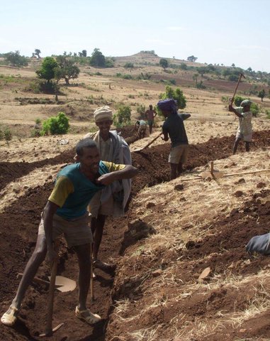
Vegetated graded soil bund is a practice or soil conservation technology for cultivated lands and constructed by excavating graded channel and form embankment. It is practiced in areas where there is excess runoff to be disposed and where there is no stones available for construction. The design specifications (ditch gradient, width and height) and layout (spacing/vertical interval) vary on the amount of excess runoff and slope of the land. Soil bund construction begins from top of the catchment. Cut off drains are constructed on top of the catchment and where needed to drain excess runoff to well stabilized natural or man-made waterways. this helps to reduce runoff impact on gullies. The bund ditch/channel should be sufficient enough to drain excess runoff safely without causing channel erosion and creating downstream damages. At same time the embankment should be stable to withstand overflows and damage due to free grazing. One technique to stabilize bunds is to plant the embankment with grass and shrub species of multiple economic value in order to compensate production area lost by bund construction. Often, the species are preferably used for livestock feed. Thus, free grazing has to be controlled. To protect damage of channels and embankments by extreme runoff and floods, frequent supervision and maintenance is required.
The purposes are:
1) Reduce nutrient loss and soil erosion by shortening the slope length,
2) Safely drain excess runoff from upstream of gully into protected waterways,
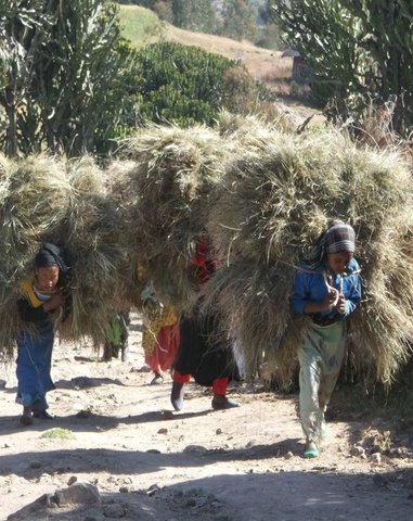
4) Produce biomass of fodder and cash values.
Vegetated graded bunds are established by doing surveying using hand level to determine the layout of the technology along the slope. During the surveying, the position of bunds (spacing) and cutoff drains and connection to waterways are determined. Bunds are laid following 0.05% gradient and up to 80 m maximum length. The specifications of the structure are: height of bund is a minimum of 60 cm after compaction; depending on the soil, base width range between 1.0 and 1.5m; top width is between 30 and 50 cm. The construction is made across different parcels owned by different land users. If there is no natural waterways and where it is appropriate, paved waterways are constructed at every 80 m or less bund length to dispose drainage water. At the beginning of the rainy season, the embankments are covered with grass and/or shrubs either by direct sowing of seeds or planting the seedlings raised in the nurseries. Monitoring of damages due to flooding and animals, maintenance of the structure as well as replanting of dead seedlings on bunds is required to sustain the soil conservation technology.
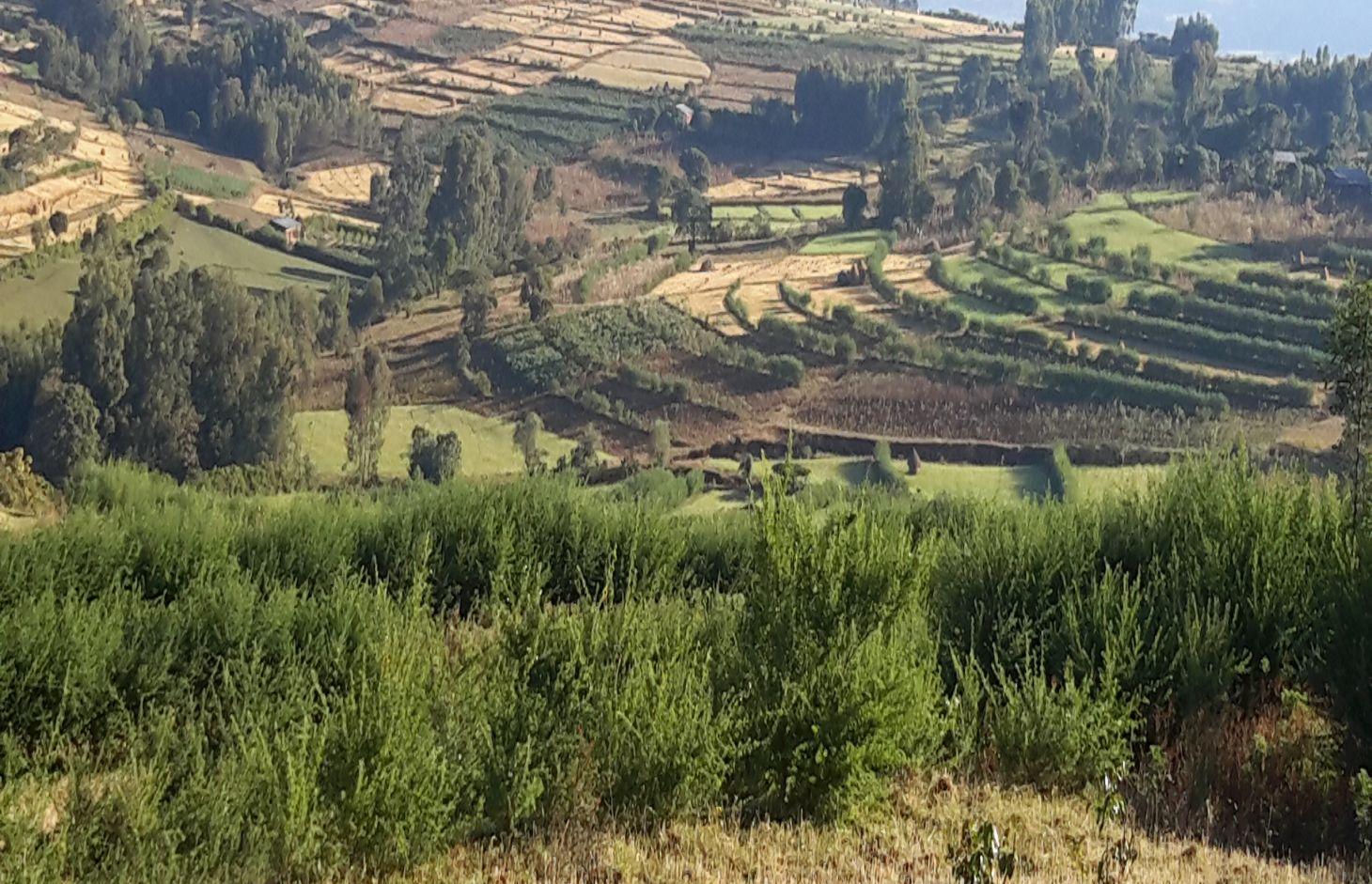
The technology is appropriately applied in high rainfall and sub-humid areas of the sub-tropics, particularly where the soil is moderately deep and poorly drained. It is constructed on cultivated lands having slopes in the range of 3-15%. The practice can be constructed by land users. It also requires collective decision and actions to drain excess runoff through waterways. The living condition depends on subsistence crop-livestock mixed farming. On average households have 5-6 family size. Crop production is meant for home consumption with small surplus for local market. The services related to water supply, energy supply, and infrastructure are low. Besides it is an asset, animals often used to cope shocks during drought periods.
2.3 Fotos da tecnologia
Galeria de Mídias
2.5 País/região/locais onde a tecnologia foi aplicada e que estão cobertos nesta avaliação
País:
Etiópia
Região/Estado/Província:
Amhara National Regional State (ANRS)
Especificação adicional de localização:
Mecha, Bahirdar Zuria and Yilmana Densa
Comentários:
Total area covered by the SLM Technology is 20 km2.
The technology is applied on specific conditions within the watersheds or area of adoption
2.6 Data da implementação
Caso o ano exato seja desconhecido, indique a data aproximada:
- menos de 10 anos atrás (recentemente)
2.7 Introdução da tecnologia
Especifique como a tecnologia foi introduzida:
- através de projetos/intervenções externas
Comentários (tipos de projeto, etc.):
The soil bunds are introduced before 30-40 years, however the integration of structural and combination of vegetative measures are applied in three years period in the WLRC learning watersheds.
3. Classificação da tecnologia de GST
3.1 Principal/principais finalidade(s) da tecnologia
- Reduz, previne, recupera a degradação do solo
3.2 Tipo(s) atualizado(s) de uso da terra onde a tecnologia foi aplicada

Terra de cultivo
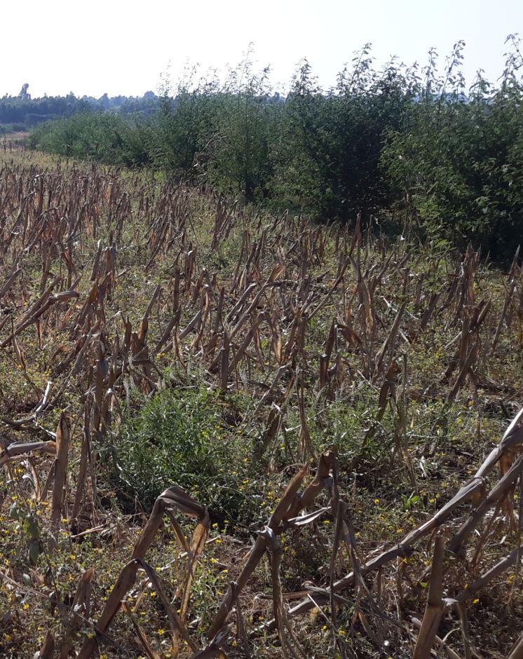
- Cultura anual
- Cultura perene (não lenhosa)
- Cultura de árvores e arbustos
- Rhamnus, Napier grass
- Cordia Africana, Polycantha, Sesbania Susban, Pigeon pea, Treelucer
Número de estações de cultivo por ano:
- 1
Especifique:
Longest growing period in days: 210, Longest growing period from month to month: June-December; Second longest growing period in days: 180, Second longest growing period from month to month: June-November

Pastagem
- free grazing
Comentários:
Major land use problems (compiler’s opinion): Land degradation due to sheet erosion, rills and gullies, soil nutrient depletion, overgrazing, shortage of fuel wood, excessive removal of crop residuals, loss of vegetation and deforestation
Major land use problems (land users’ perception): Soil erosion, soil nutrient depletion, shortage of pasture
3.4 Abastecimento de água
Abastecimento de água para a terra na qual a tecnologia é aplicada:
- Irrigação completa
3.5 Grupo de GST ao qual pertence a tecnologia
- Medidas de curva de nível
3.6 Medidas de GST contendo a tecnologia

Medidas vegetativas
- V1: cobertura de árvores/arbustos
- V2: gramíneas e plantas herbáceas perenes

Medidas estruturais
- S2: Barragens, bancos
- S3: Valas graduadas, canais, vias navegáveis
Comentários:
Type of vegetative measures: aligned: -graded strips
3.7 Principais tipos de degradação da terra abordados pela tecnologia

Erosão do solo pela água
- Wt: Perda do solo superficial/erosão de superfície
- Wo: efeitos de degradação externa

Degradação da água
- Hs: mudança na quantidade de água de superfície
Comentários:
Main causes of degradation: soil management (High tillage frequency on annual basis and steep slope cultivation), crop management (annual, perennial, tree/shrub) (The cropping system is cereal based that induce erosion), overgrazing (Livestock graze on crop residues after harvesting of crops), Heavy / extreme rainfall (intensity/amounts) (Extreme rainfall cause for high erosion), other natural causes (avalanches, volcanic eruptions, mud flows, highly susceptible natural resources, extreme topography, etc.) specify (Steep slopes or rugged topography), population pressure (Result in expansion of crop lands to steeper slopes)
Secondary causes of degradation: deforestation / removal of natural vegetation (incl. forest fires) (Deforestation of scattered trees in the farm and forests upstream of crop lands), land tenure (Insecure tenure play role not to invest on long term), poverty / wealth (Poor can not afford to invest on soil conservation on his parcel), education, access to knowledge and support services, governance / institutional
3.8 Redução, prevenção ou recuperação da degradação do solo
Especifique o objetivo da tecnologia em relação a degradação da terra:
- Reduzir a degradação do solo
4. Especificações técnicas, implementação de atividades, entradas e custos
4.1 Desenho técnico da tecnologia
Especificações técnicas (relacionada ao desenho técnico):
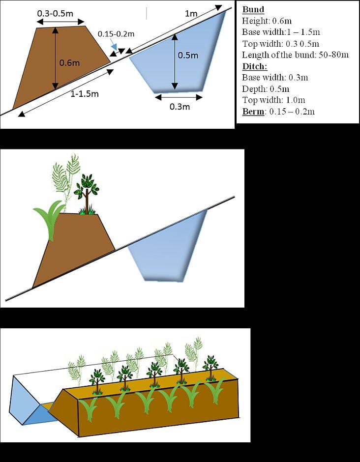
Vegetated graded soil bund showing the excavated ditch or channel and the embankment planted with grass and shrubs
Location: Amhara Region. Mecha, Yilmana Densa, Bahir Dar Zuria and Dessie Z
Technical knowledge required for field staff / advisors: high (Layout and design specification of soil bunds and cutoff drains vary on soil types, slopes, and rainfall conditions. Experts thus should acquire knowledge on specific hydrologic conditions)
Technical knowledge required for land users: moderate (Land users need skill to layout and construct bunds, monitor structures before the occurrence of excessive damage, and do regular maintenance)
Main technical functions: control of dispersed runoff: impede / retard, reduction of slope length, sediment retention / trapping, sediment harvesting, increase of biomass (quantity)
Secondary technical functions: control of dispersed runoff: retain / trap, reduction of slope angle, increase / maintain water stored in soil, increase of groundwater level / recharge of groundwater
Aligned: -graded strips
Vegetative material: T : trees / shrubs, C : perennial crops, G : grass
Number of plants per (ha): T=5333, C=160, G=1600
Vertical interval between rows / strips / blocks (m): 1-1.5
Spacing between rows / strips / blocks (m): 10-20
Vertical interval within rows / strips / blocks (m): T=0.3, C=5, G=0.5
Width within rows / strips / blocks (m): 0.3
Trees/ shrubs species: Cordia Africana, Polycantha, Sesbania Susban, Pigeon pea, Treelucer
Perennial crops species: Rhamnus
Grass species: Napier grass
Slope (which determines the spacing indicated above): 3-15%
Gradient along the rows / strips: 0.05%
Diversion ditch/ drainage
Depth of ditches/pits/dams (m): 0.3-0.7
Width of ditches/pits/dams (m): 1.2-2.8
Length of ditches/pits/dams (m): 100-250
Waterway
Depth of ditches/pits/dams (m): 0.3
Width of ditches/pits/dams (m): 1.5-2.0
Bund/ bank: graded
Vertical interval between structures (m): 1-1.5
Spacing between structures (m): 10-20
Depth of ditches/pits/dams (m): 0.5
Width of ditches/pits/dams (m): 0.3
Height of bunds/banks/others (m): 0.6
Width of bunds/banks/others (m): 1-1.5
Length of bunds/banks/others (m): 50-80
Construction material (earth): in-situ excavated soil
Slope (which determines the spacing indicated above): 3-15%
Lateral gradient along the structure: 0.05%
Vegetation is used for stabilisation of structures.
Autor:
Bekure Melesse, WLRC, P.O.Box 8707, Addis Ababa, Ethiopia
4.2 Informação geral em relação ao cálculo de entradas e custos
Outro/moeda nacional (especifique):
ETH BIRR
Se for relevante, indique a taxa de câmbio do USD para moeda local (por exemplo, 1 USD = 79,9 Real): 1 USD =:
20,0
Indique a média salarial da mão-de-obra contratada por dia:
2.50
4.3 Atividades de implantação
| Atividade | Periodicidade (estação do ano) | |
|---|---|---|
| 1. | Preparing planting materials | January-May |
| 2. | Preparation of planting materials | January-May |
| 3. | Transportation of grass splits/cuttings | Start of rainy season/July |
| 4. | Transporting tree seedlings | Start of rain season/July |
| 5. | Planting grass splits/cuttings | Start of rainy season/July |
| 6. | Sowing seeds on bunds | Start of rainy season/July |
| 7. | Planting tree seedlings on bunds | Starting of rainy season/July |
| 8. | Surveying (layout of structures) | After crop harvest and before first tillage operation |
| 9. | Construction of cutoff drains | January-April |
| 10. | Construction of bunds (ditch and embankment) | January-April |
| 11. | Construction of waterways | January - April |
4.4 Custos e entradas necessárias para a implantação
| Especifique a entrada | Unidade | Quantidade | Custos por unidade | Custos totais por entrada | % dos custos arcados pelos usuários da terra | |
|---|---|---|---|---|---|---|
| Mão-de-obra | labour | ha | 1,0 | 1107,0 | 1107,0 | 79,0 |
| Equipamento | animal traction | ha | 1,0 | 4,0 | 4,0 | 100,0 |
| Equipamento | tools | ha | 1,0 | 300,6 | 300,6 | 50,0 |
| Material vegetal | seedlings | ha | 1,0 | 32,0 | 32,0 | 100,0 |
| Material vegetal | seeds | ha | 1,0 | 9,0 | 9,0 | 100,0 |
| Material vegetal | compost manure | ha | 1,0 | 2,0 | 2,0 | 100,0 |
| Material de construção | stone | ha | 1,0 | 1300,0 | 1300,0 | 100,0 |
| Material de construção | wood | ha | 1,0 | 110,0 | 110,0 | 100,0 |
| Material de construção | earth | ha | 1,0 | 25,2 | 25,2 | 100,0 |
| Custos totais para a implantação da tecnologia | 2889,8 | |||||
| Custos totais para o estabelecimento da Tecnologia em USD | 144,49 | |||||
Comentários:
Duration of establishment phase: 15 month(s)
4.5 Atividades recorrentes/manutenção
| Atividade | Periodicidade/frequência | |
|---|---|---|
| 1. | Preparation of planting materials | January - May |
| 2. | Transportation of seedlings | July |
| 3. | Re-plantation of seedlings and grass splits | July |
| 4. | Maintenance of bunds, cutoff drain and waterways | January-April |
4.6 Custos e entradas necessárias pata a manutenção/atividades recorrentes (por ano)
| Especifique a entrada | Unidade | Quantidade | Custos por unidade | Custos totais por entrada | % dos custos arcados pelos usuários da terra | |
|---|---|---|---|---|---|---|
| Mão-de-obra | labour | ha | 1,0 | 279,0 | 279,0 | 100,0 |
| Material vegetal | seedlings | ha | 1,0 | 20,0 | 20,0 | 100,0 |
| Custos totais para a manutenção da tecnologia | 299,0 | |||||
| Custos totais de manutenção da Tecnologia em USD | 14,95 | |||||
Comentários:
Machinery/ tools: Cart, plastic tubes, spade, pickaxe, hand level, graduated ranging pole, spade, pickaxe, crowbar, hammer
The costs are calculated based on the labour, seedling/seed, grass splits required per hectare
4.7 Fatores mais importantes que afetam os custos
Descreva os fatores mais determinantes que afetam os custos:
The cost variation in implementing vegetated soil bund is dependent upon availability of stones, workability of the soil, cost of seeds or seedlings for plantation, and distance for transporting seedlings.
5. Ambiente natural e humano
5.1 Clima
Precipitação pluviométrica anual
- <250 mm
- 251-500 mm
- 501-750 mm
- 751-1.000 mm
- 1.001-1.500 mm
- 1.501-2.000 mm
- 2.001-3.000 mm
- 3.001-4.000 mm
- > 4.000 mm
Especificações/comentários sobre a pluviosidade:
Monsoon, 5-6 months rain and 6-7 dry months
Zona agroclimática
- Subúmido
Thermal climate class: subtropics. he lowest temperature is above 5oc but below 18oc etween November to January
5.2 Topografia
Declividade média:
- Plano (0-2%)
- Suave ondulado (3-5%)
- Ondulado (6-10%)
- Moderadamente ondulado (11-15%)
- Forte ondulado (16-30%)
- Montanhoso (31-60%)
- Escarpado (>60%)
Formas de relevo:
- Planalto/planície
- Cumes
- Encosta de serra
- Encosta de morro
- Sopés
- Fundos de vale
Zona de altitude:
- 0-100 m s.n.m.
- 101-500 m s.n.m.
- 501-1.000 m s.n.m.
- 1.001-1.500 m s.n.m.
- 1.501-2.000 m s.n.m.
- 2.001-2.500 m s.n.m.
- 2.501-3.000 m s.n.m.
- 3.001-4.000 m s.n.m.
- > 4.000 m s.n.m.
5.3 Solos
Profundidade do solo em média:
- Muito raso (0-20 cm)
- Raso (21-50 cm)
- Moderadamente profundo (51-80 cm)
- Profundo (81-120 cm)
- Muito profundo (>120 cm)
Textura do solo (solo superficial):
- Médio (limoso, siltoso)
- Fino/pesado (argila)
Matéria orgânica do solo superficial:
- Médio (1-3%)
- Baixo (<1%)
5.4 Disponibilidade e qualidade de água
Lençol freático:
5-50 m
Disponibilidade de água de superfície:
Médio
Qualidade da água (não tratada):
Água potável precária (tratamento necessário)
5.5 Biodiversidade
Diversidade de espécies:
- Baixo
5.6 Características dos usuários da terra que utilizam a tecnologia
Orientação de mercado do sistema de produção:
- Subsistência (autoabastecimento)
- misto (subsistência/comercial)
Rendimento não agrícola:
- Menos de 10% de toda renda
Nível relativo de riqueza:
- Pobre
- Média
Indivíduos ou grupos:
- Indivíduo/unidade familiar
Nível de mecanização:
- Trabalho manual
- Tração animal
Gênero:
- Mulheres
- Homens
Indique outras características relevantes dos usuários da terra:
Land users applying the Technology are mainly common / average land users
Difference in the involvement of women and men: Women are involved in the construction of bunds with role of collecting stones, stabilize/compact the embankments and sometimes help men in excavating the earth
Population density: 200-500 persons/km2
Annual population growth: 2% - 3%
80% of the land users are average wealthy.
20% of the land users are poor.
Off-farm income specification: Land users often do not have access to off-farm income unless those who are young and own small size of land go for seasonal labor to towns during the slack period
5.7 Área média de terrenos utilizados pelos usuários de terrenos que aplicam a Tecnologia
- < 0,5 ha
- 0,5-1 ha
- 1-2 ha
- 2-5 ha
- 5-15 ha
- 15-50 ha
- 50-100 ha
- 100-500 ha
- 500-1.000 ha
- 1.000-10.000 ha
- > 10.000 ha
É considerado pequena, média ou grande escala (referente ao contexto local)?
- Pequena escala
5.8 Propriedade de terra, direitos de uso da terra e de uso da água
Propriedade da terra:
- Estado
Direitos do uso da terra:
- Indivíduo
Direitos do uso da água:
- Acesso livre (não organizado)
- Comunitário (organizado)
5.9 Acesso a serviços e infraestrutura
Saúde:
- Pobre
- Moderado
- Bom
Educação:
- Pobre
- Moderado
- Bom
Assistência técnica:
- Pobre
- Moderado
- Bom
Emprego (p. ex. não agrícola):
- Pobre
- Moderado
- Bom
Mercados:
- Pobre
- Moderado
- Bom
Energia:
- Pobre
- Moderado
- Bom
Vias e transporte:
- Pobre
- Moderado
- Bom
Água potável e saneamento:
- Pobre
- Moderado
- Bom
Serviços financeiros:
- Pobre
- Moderado
- Bom
6. Impactos e declarações finais
6.1 Impactos no local mostrados pela tecnologia
Impactos socioeconômicos
Produção
Produção agrícola
Comentários/especificar:
Crop yield increase on sedimentation area of bunds
Produção de forragens
Comentários/especificar:
Introduction of fodder crops on bunds
Qualidade da forragem
Comentários/especificar:
Introduction of high value forage crops
Área de produção
Comentários/especificar:
The area used for ditch construction can be taken as a loss of land
Gestão de terra
Comentários/especificar:
In slope classes where spacing is narrow farm operation will be hindered
Renda e custos
Rendimento agrícola
Comentários/especificar:
Increase in income due to yield increase and fodder production
Impactos socioculturais
Instituições comunitárias
Comentários/especificar:
Watershed users committee established to regulate the development
Conhecimento de GST/ degradação da terra
Comentários/especificar:
Field staffs and land users aware of erosion and soil conservation
Atenuação de conflitos
contribution to human well-being
Comentários/especificar:
The technology aim to reduce the soil loss and improving the soil moisture to produce crops. On the other hand, the fodder production on bunds increase livestock productivity. Through improving crop and livestock productivity the livelihood of the watershed people is improved in long terms.
Impactos ecológicos
Ciclo hídrico/escoamento
Quantidade de água
Comentários/especificar:
Overall effect of bunds show increase in surface water downstreams
Escoamento superficial
Comentários/especificar:
reduction of concentrated runoff
Solo
Umidade do solo
Comentários/especificar:
Increase the rate of infiltration
Perda de solo
Comentários/especificar:
Soil loss is reduced by breaking the slope length
6.2 Impactos externos mostrados pela tecnologia
Caudal confiável e estável em período seco
Comentários/especificar:
In good drainage soils it increases infiltrated water and interflows
Cheias de jusante
Comentários/especificar:
Since it helps to reduce concentration of runoff it contributes to reduce flooding
Sedimentação a jusante
Comentários/especificar:
The main function of bunds is to reduce soil loss
Danos em áreas vizinhas
Comentários/especificar:
All fields are treated with integrated bund, cutoff drain and waterways
6.3 Exposição e sensibilidade da tecnologia às mudanças climáticas graduais e extremos/desastres relacionados ao clima (conforme o ponto de vista dos usuários da terra)
Extremos (desastres) relacionados ao clima
Desastres meteorológicos
| Como a tecnologia lida com isso? | |
|---|---|
| Temporal local | bem |
Desastres hidrológicos
| Como a tecnologia lida com isso? | |
|---|---|
| Inundação geral (rio) | não bem |
Comentários:
The technology has sufficient drainage ditch to tolerate excess runoff occurred during heavy rainfall events. However, it is sensitive to floods unless flood management measures such as strong cutoff drains and waterways are implemented
6.4 Análise do custo-benefício
Como os benefícios se comparam aos custos de implantação (do ponto de vista dos usuários da terra)?
Retornos a curto prazo:
levemente positivo
Retornos a longo prazo:
positivo
Como os benefícios se comparam aos custos recorrentes/de manutenção(do ponto de vista dos usuários da terra)?
Retornos a curto prazo:
positivo
Retornos a longo prazo:
muito positivo
Comentários:
The short term economic benefits of the technology includes increase in fodder production and slightly crop productivity due to improved soil moisture. Whereas the long term benefit can be obtained as a result of increased yield on areas where sediment accumulation occurs as well as production of fodder on soil bunds for livestock feed
6.5 Adoção da tecnologia
Comentários:
The technology is implemented using community mobilization approach which involves all land users. All land users, who cultivate land in areas where bunds are suitable, implemented the technology. All parcels are covered with the technology/bunds except homesteads and degraded hillsides and gullies which are treated with different SLM technologies
Since the approach encourages collective action (through community organizations) to integrate different SLM technologies in the watershed level, there is no attempt by individual land users. However, there are motivations and implementation of land users on adjacent watersheds to implement the technology.
There is a moderate trend towards spontaneous adoption of the Technology
The trend is at increasing rate although land users need material support such as multipurpose seedlings to stabilize bunds. There is shortage of supply of fodder seeds. Community nurseries are inadequate and not well supported to raise seedlings to meet community demands.
6.7 Pontos fortes/vantagens/oportunidades da tecnologia
| Pontos fortes/vantagens/oportunidades na visão do usuário da terra |
|---|
| Increase in fodder production for livestock feed |
| Reduce conflict among adjacent land users (i.e., upstream and downstream land users) that arise due to concentrated runoff |
| Reduce soil erosion |
| Pontos fortes/vantagens/oportunidades na visão do/a compilador/a ou de outra pessoa capacitada |
|---|
| The technology reduces soil loss and associated nutrient loss significantly in the first 3 to 4 years and further reduce siltation of reservoirs and land degradation |
| Increase the soil moisture in the landscape/watershed |
| Improves the greenness, soil carbon and micro-climate |
| Increase level of awareness of land users to produce fodder and diversify production and income |
| Reduce the concentration of runoff and safely drain without causing damage |
6.8 Pontos fracos, desvantagens/riscos da tecnologia e formas de superá-los
| Pontos fracos/desvantagens/riscos na visão do usuário da terra | Como eles podem ser superados? |
|---|---|
| Hinder farm operations like turning oxen become difficult while ploughing | It can be sustained through proper layout and allow space for human and animal paths |
| Plantation on bunds harbor birds | This can be avoided by harvesting the mature branches of the shrubs for livestock feed on seasonal basis. |
| Appearance of new weeds species along the drainage ditches | Regular weed monitoring and manual control |
| Hinders livestock to graze on crop residues | Try to use cut and carry grazing system (both crop residues and fodders) and develop forage development strategies in every possible niches |
| Pontos fracos/vantagens/riscos na visão do/a compilador/a ou de outra pessoa capacitada | Como eles podem ser superados? |
|---|---|
| High labor requirement to establish and maintain the technology | Increase the awareness level of land users and strength collective actions and local organizational setups |
| Small land loss for construction | Introduce production options (like fodder production) on bunds to compensate the lost land |
| It requires some years to accumulate sediment on bund area and form bench | It can be improved by modifying the design of drainage ditchs |
7. Referências e links
7.1 Métodos/fontes de informação
- visitas de campo, pesquisas de campo
- entrevistas com usuários de terras
Quando os dados foram compilados (no campo)?
12/05/2014
7.2 Referências às publicações disponíveis
Título, autor, ano, ISBN:
Vegetated Graded Soil Bund: A Technique to Reduce Runoff Impact and Increase Soil Moisture Storage and Fodder Biomass, WLRC Brief No. 4
Disponível de onde? Custos?
WWW.wlrc-eth.org
Links e módulos
Expandir tudo Recolher tudoLinks
Community Organizations and Mobilization for Soil and Water … [Etiópia]
Community mobilization for soil and water conservation work in a watershed planning unit is an approach for collective action by organizing all active labor forces living in the kebele/peasant association into development group of 20-30 members and further divide into 1:5 work force to implement construction of soil and water …
- Compilador/a: Gizaw Desta Gessesse
'Cut and Carry' Grazing system or 'Zero Grazing' … [Etiópia]
Cut and carry grazing system (alternatively called zero grazing) is an approach where the community is consulted to identify and agree on areas to be closed and protected from free grazing; establish user groups are established to share the fodder biomass harvested from communal closed areas equitably; they utilize tree/shrub …
- Compilador/a: Gizaw Desta Gessesse
Módulos
Não há módulos