Lining irrigation canals [Mali]
- Criação:
- Atualização:
- Compilador/a: Dieter Nill
- Editor: –
- Revisores: Deborah Niggli, Alexandra Gavilano
Revêtement des canaux d’irrigation (French)
technologies_1651 - Mali
Veja as seções
Expandir tudo Recolher tudo1. Informação geral
1.2 Detalhes do contato das pessoas capacitadas e instituições envolvidas na avaliação e documentação da tecnologia
Especialista em GST:
Traore Minamba
IICEM
Mali
Nome do projeto que facilitou a documentação/avaliação da Tecnologia (se relevante)
Manual of Good Practices in Small Scale Irrigation in the Sahel (GIZ )Nome da(s) instituição(ões) que facilitou(ram) a documentação/ avaliação da Tecnologia (se relevante)
Deutsche Gesellschaft für Internationale Zusammenarbeit (GIZ) - Alemanha1.3 Condições em relação ao uso da informação documentada através de WOCAT
O compilador e a(s) pessoa(s) capacitada(s) aceitam as condições relativas ao uso de dados documentados através do WOCAT:
Sim
1.4 Declaração de sustentabilidade da tecnologia descrita
A tecnologia descrita aqui é problemática em relação a degradação da terra de forma que não pode ser declarada uma tecnologia de gestão sustentável de terra?
Não
2. Descrição da tecnologia de GST
2.1 Descrição curta da tecnologia
Definição da tecnologia:
Lining canals is a powerful way to save irrigation water by minimising seepage losses, and to reduce pumping time and costs.
2.2 Descrição detalhada da tecnologia
Descrição:
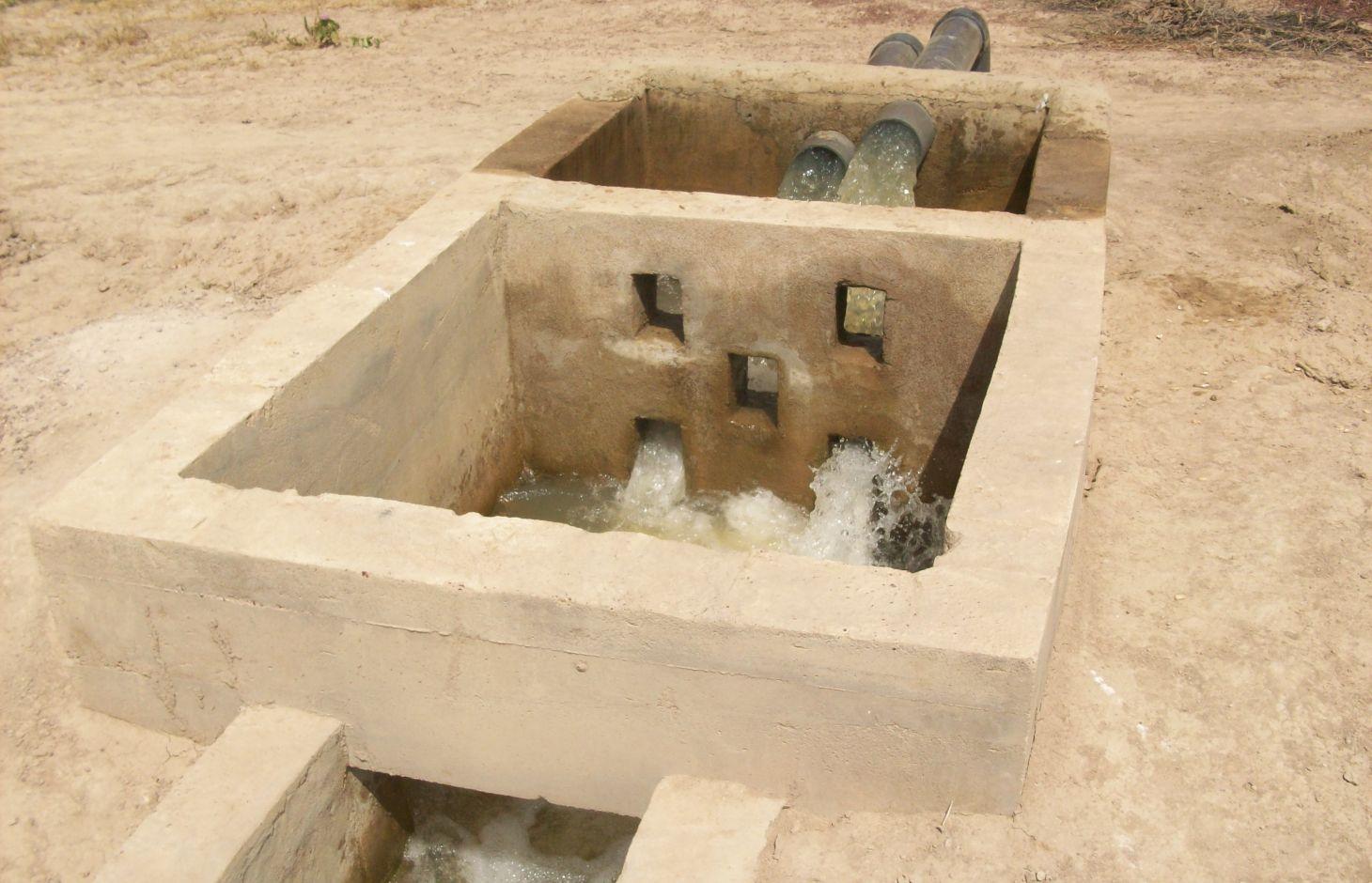
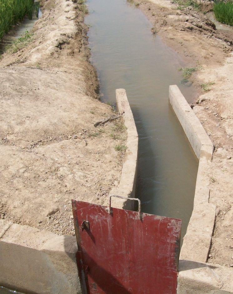
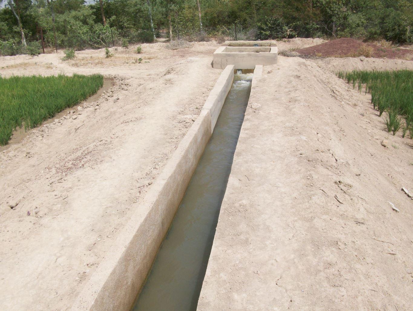
The irrigation area’s main earthen canals have their inverts lined in concrete and their sides lined with solid cement blocks. Concrete support posts are set at intervals and capped in concrete. Each lined main canal should be no longer than two kilometres. The main canal’s turnouts into the secondary canals are built in cement and are equipped with gates that can be opened and closed as required.
Each turnout’s outflow area is protected by a rockfill structure that is built right up to the top of the canal wall to prevent the canal banks at the head of the secondary canals from becoming degraded.
Lining is mainly used to improve the efficiency of existing irrigation systems. Once the canal has been lined, yields increase by between 35% and 80%. This is because crops receive the water they need to ripen as and when it is required. Often, lining also makes it possible to extend the irrigated area. Pumping hours per hectare are considerably reduced (by 25% in the rainy season) because the canals ensure the correct distribution of irrigation water. Consequently, irrigation costs per tonne of produce drop due to the reduction in pumping hours and the costs of periodical maintenance and increases in yields.
Together with the growers, a memorandum of understanding was drawn up with IICEM and then signed by the mayor. The memorandum describes all the activities that form part of the collaboration between IICEM and the various beneficiaries. The works were carried out either in-company or constituted part of the highly labour-intensive work (HLIW).
a) Work delivered in-company (turnkey basis): Works are carried out in several stages: 1) Identifying the sites requiring lining. This involves locating the sites to develop and making contact with the NGOs that represent the project in the region, as well as regional directorates of rural engineering and economic operators working with the farming organisations in question. 2) The delimited sites chosen for development must undergo technical studies, which are entrusted to engineering consultancies recruited through an open tender process in accordance with the terms of reference for the studies to be conducted. 3) The technical feasibility studies comprise topographical, geotechnical, soil and environmental studies, as well as the creation of a development plan and quantification of materials required for the construction work. 4) Drawing up the invitation to tender (ITT) documents and communicating the tender process to businesses. In lieu of a ToR, an ITT is created by the project according to the requirements of the site. It is then published so that interested consultancies can put forward their bids. 5) Works are carried out under the control and supervision of the oversight office to ensure they adhere to professional standards.
b) Highly labour-intensive work: 1) The same as above. 2) Topographical surveys are carried out by IICEM specialists to calculate the calibration of the canals to ensure they are able to submerge plots over a large area. 3) After calibrating the schemes (energy dissipation basin and division box, main canal and secondary canal turnout, channel), a work plan is drawn up. This uses the measurements calculated to quantify construction material and equipment requirements. 4) Teams of (preferably local) builders are recruited to line the canals. The teams comprise master builders, reinforcing ironworkers, bricklayers and surveyors. 5) The materials and equipment required for each site are provided by an appropriate supplier recruited through a tendering process. 6) Provision of labour and farmer participation. Only the building contractors are paid for working on the project. Labour is supplied by the local community who are provided with lunch to maintain motivation and to prevent lost time caused by workers going off-site. 7) In villages where schemes are proposed, teams of shift workers from the local community are set up and trained in proper conduct for working on a canal lining project and in the keeping of a construction project log book.
Once the canal lining works are complete, IICEM provides a pump unit and subsidises the required fuel and consumables for one growing season. Training in how to run and maintain pump units is provided for the local beneficiaries tasked with their upkeep. Furthermore, training in the management and maintenance of irrigation schemes is delivered to the farming organisations’ steering committee.
The lifespan of a canal lining ranges from 10 to 20 years if small repairs are regularly undertaken. Ensuring linings are impermeable is of the utmost importance because water penetrating through micro-cracks as it flows through the network can lead to rapid and major water loss. It is therefore essential that producers can maintain installations and repair cracks.
The Sahel is a region where the population has always faced a high degree of climate variability, manifested both in terms of time (unexpected dry spells can occur during the rainy season) and in terms of space (rainfall can vary greatly from one area to another). The population is mainly composed of small farmers and livestock keepers.
Over the last two decades, the effects of climate change have exacerbated the already difficult conditions. Accord¬ing to projections made by climatologists, the Sahel will experience a rise in temperatures combined with highly variable rainfall and an increase in extreme weather events.
The Soil and Water conservation and rehabilitation techniques have helped people in the Sahel to manage their ecosystems more effectively and improve their productive land. As a result, communities are better prepared to cope with environmental changes (changes in the climate, land degradation, etc.) and the im¬pact of shocks, particularly droughts
2.3 Fotos da tecnologia
Galeria de Mídias
2.5 País/região/locais onde a tecnologia foi aplicada e que estão cobertos nesta avaliação
País:
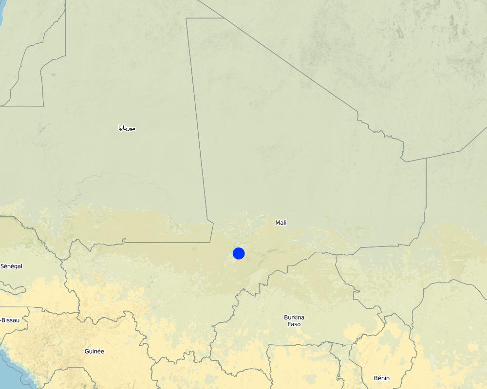
Mali
Região/Estado/Província:
Mali
Especificação adicional de localização:
Mopti, Timbuktu, Gao, Sikasso
Especifique a difusão da tecnologia:
- Uniformemente difundida numa área
Se a Tecnologia estiver uniformemente distribuída por uma área, especifique a área coberta (em km2):
12,0
Comentários:
Total area covered by the SLM Technology is 12 km2.
Around 50 sites covering approximately 1200 hectares have had their canals lined
Map
×2.6 Data da implementação
Caso o ano exato seja desconhecido, indique a data aproximada:
- menos de 10 anos atrás (recentemente)
2.7 Introdução da tecnologia
Especifique como a tecnologia foi introduzida:
- através de projetos/intervenções externas
Comentários (tipos de projeto, etc.):
This kind of practice has been carried out by IICEM since 2009.
3. Classificação da tecnologia de GST
3.1 Principal/principais finalidade(s) da tecnologia
- Melhora a produção
- Preserva ecossistema
3.2 Tipo(s) atualizado(s) de uso da terra onde a tecnologia foi aplicada
Uso do solo misturado dentro da mesma unidade de terra:
Sim
Especificar o uso misto da terra (culturas/ pastoreio/ árvores):
- Agropecuária (incl. agricultura e pecuária)

Terra de cultivo
- Cultura anual
Número de estações de cultivo por ano:
- 1
Especifique:
Longest growing period in days: 120Longest growing period from month to month: August-November

Pastagem

Vias navegáveis, corpo d'água, zonas úmidas
- Linhas de drenagem, vias navegáveis
Comentários:
Major land use problems (compiler’s opinion): unequal distribution of irrigation water, ineffective irrigation systems (water loss)
Livestock density: 1-10 LU /km2
3.4 Abastecimento de água
Abastecimento de água para a terra na qual a tecnologia é aplicada:
- Misto de precipitação natural-irrigado
3.5 Grupo de GST ao qual pertence a tecnologia
- Gestão de pastoralismo e pastagem
- Gestão de irrigação (inclusive abastecimento de água, drenagem)
- Desvio e drenagem de água
3.6 Medidas de GST contendo a tecnologia

Medidas estruturais
- S3: Valas graduadas, canais, vias navegáveis
3.7 Principais tipos de degradação da terra abordados pela tecnologia

Erosão do solo pela água
- Wr: erosão das margens

Deteriorização química do solo
- Cn: declínio de fertilidade e teor reduzido de matéria orgânica (não causado pela erosão)

Degradação biológica
- Bc: redução da cobertura vegetal

Degradação da água
- Ha: aridificação
Comentários:
Main causes of degradation: soil management (Unadapted landuse methods, reduced or abandoned fallow periods), crop management (annual, perennial, tree/shrub) (Neglect of fallow periods and crop rotation), over abstraction / excessive withdrawal of water (for irrigation, industry, etc.), droughts (due to heat waves), population pressure (rapidly growing population increasing pressure on land), land tenure (insecure access to land and collectively managed communal land), poverty / wealth (very poor population)
Secondary causes of degradation: deforestation / removal of natural vegetation (incl. forest fires) (deforestation through overgrazing and fire wood collection), over-exploitation of vegetation for domestic use (firewood collection), overgrazing (cattle, sheep and goats), change in temperature (Climate change: heat waves), change of seasonal rainfall (more variable onset of rain), Heavy / extreme rainfall (intensity/amounts) (more variable and intensive rains), wind storms / dust storms (frequent storms), floods (due to intensive rain storms), labour availability (some migration of men to nearby cities), education, access to knowledge and support services (high level of illiteracy)
3.8 Redução, prevenção ou recuperação da degradação do solo
Especifique o objetivo da tecnologia em relação a degradação da terra:
- Prevenir degradação do solo
- Reduzir a degradação do solo
4. Especificações técnicas, implementação de atividades, entradas e custos
4.1 Desenho técnico da tecnologia
Especificações técnicas (relacionada ao desenho técnico):
The irrigation area’s main earthen canals have their inverts lined in concrete and their sides lined with solid cement blocks. Concrete support posts are set at intervals and capped in concrete. Each lined main canal should be no longer than two kilometres. The main canal’s turnouts into the secondary canals are built in cement and are equipped with gates that can be opened and closed as required. Each turnout’s outflow area is protected by a rockfill structure that is built right up to the top of the canal wall to prevent the canal banks at the head of the secondary canals from becoming degraded.
Technical knowledge required for field staff / advisors: high
Technical knowledge required for land users: low
Main technical functions: water harvesting / increase water supply, water spreading
Autor:
Minamba Traore, IICEM
4.2 Informação geral em relação ao cálculo de entradas e custos
Outro/moeda nacional (especifique):
CFA Franc
Se for relevante, indique a taxa de câmbio do USD para moeda local (por exemplo, 1 USD = 79,9 Real): 1 USD =:
512,0
4.3 Atividades de implantação
| Atividade | Periodicidade (estação do ano) | |
|---|---|---|
| 1. | Identifying the sites requiring lining | |
| 2. | Launching the invitation to tender for the technical studies / Undertaking topographical surveys to calibrate schemes | |
| 3. | Performing the technical studies / Quantifying building material requirements | |
| 4. | Drawing up the invitation to tender (ITT) documents and communicating the tender process to businesses / Recruitment of masons, bricklayers and reinforcing ironworkers | |
| 5. | Delivery of works under the supervision of the oversight office / Invitation to tender for the provision of materials and equipment | |
| 6. | Provision of labour and farmer participation | |
| 7. | Training workers from the local community in building site conduct |
4.5 Atividades recorrentes/manutenção
| Atividade | Periodicidade/frequência | |
|---|---|---|
| 1. | small repairs are regularly undertaken |
4.7 Fatores mais importantes que afetam os custos
Descreva os fatores mais determinantes que afetam os custos:
Around 50 sites covering approximately 1,200 hectares have had their canals lined. Total costs: 1,587,865.50 US Dollar
5. Ambiente natural e humano
5.1 Clima
Precipitação pluviométrica anual
- <250 mm
- 251-500 mm
- 501-750 mm
- 751-1.000 mm
- 1.001-1.500 mm
- 1.501-2.000 mm
- 2.001-3.000 mm
- 3.001-4.000 mm
- > 4.000 mm
Zona agroclimática
- Semiárido
5.2 Topografia
Declividade média:
- Plano (0-2%)
- Suave ondulado (3-5%)
- Ondulado (6-10%)
- Moderadamente ondulado (11-15%)
- Forte ondulado (16-30%)
- Montanhoso (31-60%)
- Escarpado (>60%)
Formas de relevo:
- Planalto/planície
- Cumes
- Encosta de serra
- Encosta de morro
- Sopés
- Fundos de vale
Zona de altitude:
- 0-100 m s.n.m.
- 101-500 m s.n.m.
- 501-1.000 m s.n.m.
- 1.001-1.500 m s.n.m.
- 1.501-2.000 m s.n.m.
- 2.001-2.500 m s.n.m.
- 2.501-3.000 m s.n.m.
- 3.001-4.000 m s.n.m.
- > 4.000 m s.n.m.
5.3 Solos
Profundidade do solo em média:
- Muito raso (0-20 cm)
- Raso (21-50 cm)
- Moderadamente profundo (51-80 cm)
- Profundo (81-120 cm)
- Muito profundo (>120 cm)
Textura do solo (solo superficial):
- Médio (limoso, siltoso)
- Fino/pesado (argila)
Matéria orgânica do solo superficial:
- Médio (1-3%)
- Baixo (<1%)
5.4 Disponibilidade e qualidade de água
Lençol freático:
5-50 m
Disponibilidade de água de superfície:
Médio
Qualidade da água (não tratada):
apenas para uso agrícola (irrigação)
5.5 Biodiversidade
Diversidade de espécies:
- Médio
5.6 Características dos usuários da terra que utilizam a tecnologia
Sedentário ou nômade:
- Sedentário
Orientação de mercado do sistema de produção:
- misto (subsistência/comercial)
Rendimento não agrícola:
- 10-50% de toda renda
Nível relativo de riqueza:
- Pobre
- Média
Nível de mecanização:
- Trabalho manual
Gênero:
- Homens
Indique outras características relevantes dos usuários da terra:
Population density: < 10 persons/km2
Annual population growth: 2% - 3%
10% of the land users are rich.
50% of the land users are average wealthy.
30% of the land users are poor.
10% of the land users are poor.
5.7 Área média de terrenos utilizados pelos usuários de terrenos que aplicam a Tecnologia
- < 0,5 ha
- 0,5-1 ha
- 1-2 ha
- 2-5 ha
- 5-15 ha
- 15-50 ha
- 50-100 ha
- 100-500 ha
- 500-1.000 ha
- 1.000-10.000 ha
- > 10.000 ha
É considerado pequena, média ou grande escala (referente ao contexto local)?
- Pequena escala
5.8 Propriedade de terra, direitos de uso da terra e de uso da água
Comentários:
The irrigated land is allocated by the chief
5.9 Acesso a serviços e infraestrutura
Saúde:
- Pobre
- Moderado
- Bom
Educação:
- Pobre
- Moderado
- Bom
Assistência técnica:
- Pobre
- Moderado
- Bom
Emprego (p. ex. não agrícola):
- Pobre
- Moderado
- Bom
Mercados:
- Pobre
- Moderado
- Bom
Energia:
- Pobre
- Moderado
- Bom
Vias e transporte:
- Pobre
- Moderado
- Bom
Água potável e saneamento:
- Pobre
- Moderado
- Bom
Serviços financeiros:
- Pobre
- Moderado
- Bom
6. Impactos e declarações finais
6.1 Impactos no local mostrados pela tecnologia
Impactos socioeconômicos
Produção
Produção agrícola
Risco de falha de produção
Área de produção
Renda e custos
Carga de trabalho
Impactos socioculturais
Segurança alimentar/auto-suficiência
Atenuação de conflitos
Impactos ecológicos
Ciclo hídrico/escoamento
Quantidade de água
Colheita/recolhimento de água
6.2 Impactos externos mostrados pela tecnologia
Caudal confiável e estável em período seco
Poluição de água subterrânea/rio
Sedimentos transportados pelo vento
6.3 Exposição e sensibilidade da tecnologia às mudanças climáticas graduais e extremos/desastres relacionados ao clima (conforme o ponto de vista dos usuários da terra)
Mudança climática gradual
Mudança climática gradual
| Estação do ano | aumento ou diminuição | Como a tecnologia lida com isso? | |
|---|---|---|---|
| Temperatura anual | aumento | bem |
Extremos (desastres) relacionados ao clima
Desastres meteorológicos
| Como a tecnologia lida com isso? | |
|---|---|
| Temporal local | não bem |
| Tempestade de vento local | bem |
Desastres climatológicos
| Como a tecnologia lida com isso? | |
|---|---|
| Seca | bem |
Desastres hidrológicos
| Como a tecnologia lida com isso? | |
|---|---|
| Inundação geral (rio) | não bem |
Outras consequências relacionadas ao clima
Outras consequências relacionadas ao clima
| Como a tecnologia lida com isso? | |
|---|---|
| Período de crescimento reduzido | não conhecido |
6.4 Análise do custo-benefício
Como os benefícios se comparam aos custos de implantação (do ponto de vista dos usuários da terra)?
Retornos a curto prazo:
levemente negativo
Retornos a longo prazo:
levemente positivo
Como os benefícios se comparam aos custos recorrentes/de manutenção(do ponto de vista dos usuários da terra)?
Retornos a curto prazo:
levemente positivo
Retornos a longo prazo:
muito positivo
6.5 Adoção da tecnologia
Comentários:
Comments on spontaneous adoption: Lining of canals is an investment which is generally only feasible with external assistance.
There is no trend towards spontaneous adoption of the Technology
Comments on adoption trend: Irrigation system canals in Mopti, Timbuktu, Gao and Sikasso have been lined.
Around 50 sites covering approximately 1,200 hectares have had their canals lined. This kind of practice has been carried out by IICEM since 2009.
6.7 Pontos fortes/vantagens/oportunidades da tecnologia
| Pontos fortes/vantagens/oportunidades na visão do compilador ou de outra pessoa capacitada |
|---|
| Lining canals is a powerful way to save irrigation water by minimising seepage losses. |
| Pumping time and costs are also greatly reduced through the speedy distribution of irrigation water supplies, and reducing the use of motorised pumps lowers maintenance costs. |
| Yields increase by between 35% and 80%. Often, lining also makes it possible to extend the irrigated area. |
| Training in how to run and maintain pump units is provided for the local beneficiaries tasked with their upkeep. Furthermore, training in the management and maintenance of irrigation schemes is delivered to the farming organisations’ steering committee |
| The lifespan of a canal lining ranges from 10 to 20 years |
7. Referências e links
7.1 Métodos/fontes de informação
- visitas de campo, pesquisas de campo
- entrevistas com usuários de terras
Quando os dados foram compilados (no campo)?
01/07/2012
7.2 Referências às publicações disponíveis
Título, autor, ano, ISBN:
Manual of Good Practices in Small Scale Irrigation in the Sahel. Experiences from Mali. Published by GIZ in 2014.
Disponível de onde? Custos?
http://star-www.giz.de/starweb/giz/pub/servlet.starweb
Título, autor, ano, ISBN:
www.iicem.net
Links e módulos
Expandir tudo Recolher tudoLinks
Não há links
Módulos
Não há módulos