Lining irrigation canals [Мали]
- Создание:
- Обновить:
- Составитель: Dieter Nill
- Редактор: –
- Рецензенты: Deborah Niggli, Alexandra Gavilano
Revêtement des canaux d’irrigation (French)
technologies_1651 - Мали
Просмотреть разделы
Развернуть все Свернуть все1. Общая информация
1.2 Контактные данные специалистов и организаций, участвующих в описании и оценке Технологии
Специалист по УЗП:
Traore Minamba
IICEM
Мали
Название проекта, содействовавшего документированию/оценке Технологии (если применимо)
Manual of Good Practices in Small Scale Irrigation in the Sahel (GIZ )Название организации (-ий), содействовавших документированию/оценке Технологии (если применимо)
Deutsche Gesellschaft für Internationale Zusammenarbeit (GIZ) - Германия1.3 Условия, регламентирующие использование данных, собранных ВОКАТ
Составитель и ответственный(-ые) специалист(-ы) согласны с условиями, регламентирующими использование собранных ВОКАТ данных:
Да
1.4 Декларация по устойчивости описываемой Технологии
Вызывает ли описанная здесь Технология проблемы деградации земель настолько, что ее нельзя назвать природосберегающей?
Нет
2. Описание Технологии УЗП
2.1 Краткое описание Технологии
Определение Технологии:
Lining canals is a powerful way to save irrigation water by minimising seepage losses, and to reduce pumping time and costs.
2.2 Подробное описание Технологии
Описание:
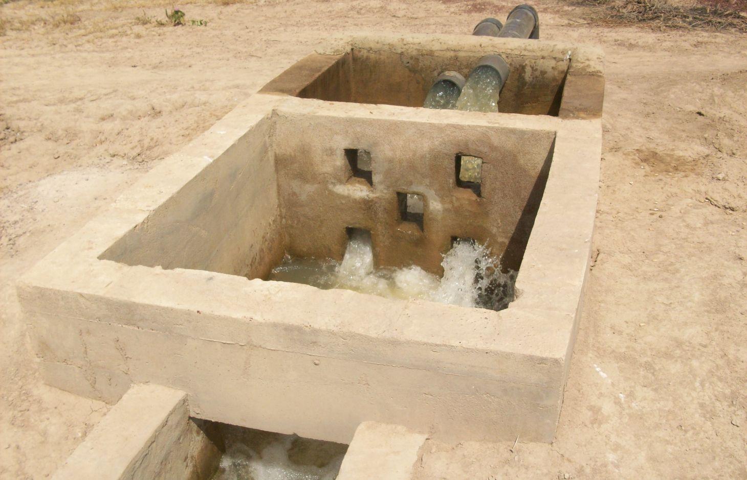
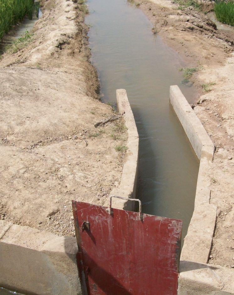
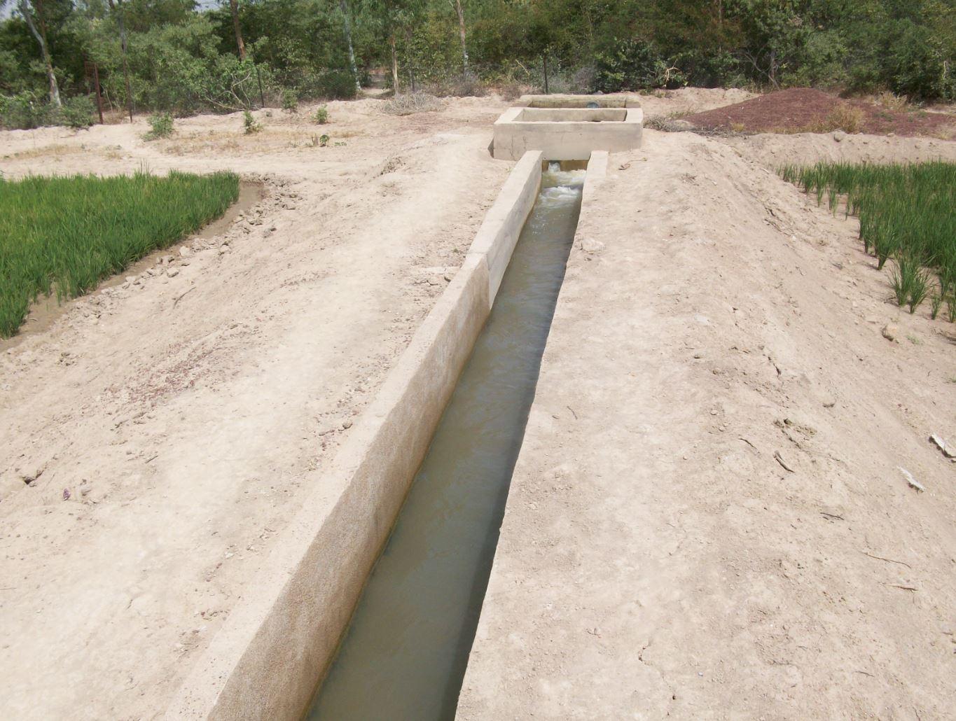
The irrigation area’s main earthen canals have their inverts lined in concrete and their sides lined with solid cement blocks. Concrete support posts are set at intervals and capped in concrete. Each lined main canal should be no longer than two kilometres. The main canal’s turnouts into the secondary canals are built in cement and are equipped with gates that can be opened and closed as required.
Each turnout’s outflow area is protected by a rockfill structure that is built right up to the top of the canal wall to prevent the canal banks at the head of the secondary canals from becoming degraded.
Lining is mainly used to improve the efficiency of existing irrigation systems. Once the canal has been lined, yields increase by between 35% and 80%. This is because crops receive the water they need to ripen as and when it is required. Often, lining also makes it possible to extend the irrigated area. Pumping hours per hectare are considerably reduced (by 25% in the rainy season) because the canals ensure the correct distribution of irrigation water. Consequently, irrigation costs per tonne of produce drop due to the reduction in pumping hours and the costs of periodical maintenance and increases in yields.
Together with the growers, a memorandum of understanding was drawn up with IICEM and then signed by the mayor. The memorandum describes all the activities that form part of the collaboration between IICEM and the various beneficiaries. The works were carried out either in-company or constituted part of the highly labour-intensive work (HLIW).
a) Work delivered in-company (turnkey basis): Works are carried out in several stages: 1) Identifying the sites requiring lining. This involves locating the sites to develop and making contact with the NGOs that represent the project in the region, as well as regional directorates of rural engineering and economic operators working with the farming organisations in question. 2) The delimited sites chosen for development must undergo technical studies, which are entrusted to engineering consultancies recruited through an open tender process in accordance with the terms of reference for the studies to be conducted. 3) The technical feasibility studies comprise topographical, geotechnical, soil and environmental studies, as well as the creation of a development plan and quantification of materials required for the construction work. 4) Drawing up the invitation to tender (ITT) documents and communicating the tender process to businesses. In lieu of a ToR, an ITT is created by the project according to the requirements of the site. It is then published so that interested consultancies can put forward their bids. 5) Works are carried out under the control and supervision of the oversight office to ensure they adhere to professional standards.
b) Highly labour-intensive work: 1) The same as above. 2) Topographical surveys are carried out by IICEM specialists to calculate the calibration of the canals to ensure they are able to submerge plots over a large area. 3) After calibrating the schemes (energy dissipation basin and division box, main canal and secondary canal turnout, channel), a work plan is drawn up. This uses the measurements calculated to quantify construction material and equipment requirements. 4) Teams of (preferably local) builders are recruited to line the canals. The teams comprise master builders, reinforcing ironworkers, bricklayers and surveyors. 5) The materials and equipment required for each site are provided by an appropriate supplier recruited through a tendering process. 6) Provision of labour and farmer participation. Only the building contractors are paid for working on the project. Labour is supplied by the local community who are provided with lunch to maintain motivation and to prevent lost time caused by workers going off-site. 7) In villages where schemes are proposed, teams of shift workers from the local community are set up and trained in proper conduct for working on a canal lining project and in the keeping of a construction project log book.
Once the canal lining works are complete, IICEM provides a pump unit and subsidises the required fuel and consumables for one growing season. Training in how to run and maintain pump units is provided for the local beneficiaries tasked with their upkeep. Furthermore, training in the management and maintenance of irrigation schemes is delivered to the farming organisations’ steering committee.
The lifespan of a canal lining ranges from 10 to 20 years if small repairs are regularly undertaken. Ensuring linings are impermeable is of the utmost importance because water penetrating through micro-cracks as it flows through the network can lead to rapid and major water loss. It is therefore essential that producers can maintain installations and repair cracks.
The Sahel is a region where the population has always faced a high degree of climate variability, manifested both in terms of time (unexpected dry spells can occur during the rainy season) and in terms of space (rainfall can vary greatly from one area to another). The population is mainly composed of small farmers and livestock keepers.
Over the last two decades, the effects of climate change have exacerbated the already difficult conditions. Accord¬ing to projections made by climatologists, the Sahel will experience a rise in temperatures combined with highly variable rainfall and an increase in extreme weather events.
The Soil and Water conservation and rehabilitation techniques have helped people in the Sahel to manage their ecosystems more effectively and improve their productive land. As a result, communities are better prepared to cope with environmental changes (changes in the climate, land degradation, etc.) and the im¬pact of shocks, particularly droughts
2.3 Фотографии, иллюстрирующие Технологию
Медиа-галерея
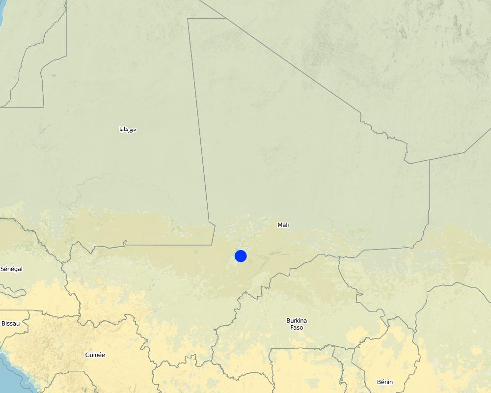
2.5 Страна/ регион/ места, где применяется Технология, информация о которых собрана в данной Анкете
Страна:
Мали
Административная единица (Район/Область):
Mali
Более точная привязка места:
Mopti, Timbuktu, Gao, Sikasso
Охарактеризуйте пространственное распространение Технологии :
- равномерно-однородное применение на определенной площади
Если технология равномерно занимает территорию, укажите площадь покрытия (в км2):
12,0
Пояснения:
Total area covered by the SLM Technology is 12 km2.
Around 50 sites covering approximately 1200 hectares have had their canals lined
Map
×2.6 Сколько лет применяется данная Технология
Если год начала применения Технологии достоверно неизвестен, дайте примерную оценку:
- менее 10 лет назад (недавняя)
2.7 Внедрение Технологии
Укажите, как именно Технология УЗП была внедрена:
- через проекты/ внешнее вмешательство
Пояснения (тип проекта и т.д.):
This kind of practice has been carried out by IICEM since 2009.
3. Классификация Технологии УЗП
3.1 Основные цели и задачи реализации Технологии
- повышение производства
- сохранение экосистем
3.2 Текущий(-ие) тип(-ы) землепользования на территории, где применяется Технология
Комбинированное землепользование в пределах одной и той же земельной единицы:
Да
Укажите сочетания типов землепользования (посевы / пастбища / деревья):
- Агро-пастбищное хозяйство ( включая растениеводство-животноводство)

Пахотные угодья и плантации
- Однолетние культуры
Число урожаев за год:
- 1
Поясните:
Longest growing period in days: 120Longest growing period from month to month: August-November

Пастбищные угодья

Водотоки, водные объекты, водно-болотные угодья
- Дренажные канавы, водотоки
Пояснения:
Major land use problems (compiler’s opinion): unequal distribution of irrigation water, ineffective irrigation systems (water loss)
Livestock density: 1-10 LU /km2
3.4 Водоснабжение
Обеспеченность водой участков, где реализуется Технология :
- сочетание богарных и орошаемых земель
3.5 Категория УЗП, к которой относится Технология
- Кочевое животноводство и пастбищное хозяйство
- Управление орошением (включая водоснабжение и дренаж)
- Водоотвод и осушение
3.6 Мероприятия УЗП, выполняемые в рамках Технологии

инженерные мероприятия
- И3: Ступенчатые канавы (арыки), каналы, водотоки
3.7 Основные проблемы деградации земель, на решение которых направлена Технология

водная эрозия почв
- ВЭрб: эрозия речных берегов

ухудшение химических свойств почв
- Хп: Снижение плодородия и уменьшение содержания органического вещества (вызванное не эрозией, а другими причинами)

биологическая деградация
- Бр: сокращение растительного покрова

деградация водных ресурсов
- Ва: почвенная засуха
Пояснения:
Main causes of degradation: soil management (Unadapted landuse methods, reduced or abandoned fallow periods), crop management (annual, perennial, tree/shrub) (Neglect of fallow periods and crop rotation), over abstraction / excessive withdrawal of water (for irrigation, industry, etc.), droughts (due to heat waves), population pressure (rapidly growing population increasing pressure on land), land tenure (insecure access to land and collectively managed communal land), poverty / wealth (very poor population)
Secondary causes of degradation: deforestation / removal of natural vegetation (incl. forest fires) (deforestation through overgrazing and fire wood collection), over-exploitation of vegetation for domestic use (firewood collection), overgrazing (cattle, sheep and goats), change in temperature (Climate change: heat waves), change of seasonal rainfall (more variable onset of rain), Heavy / extreme rainfall (intensity/amounts) (more variable and intensive rains), wind storms / dust storms (frequent storms), floods (due to intensive rain storms), labour availability (some migration of men to nearby cities), education, access to knowledge and support services (high level of illiteracy)
3.8 Предотвращение и снижение деградации земель, или восстановление нарушенных земель
Укажите цель Технологии по отношению к деградации земель :
- предотвращение деградации земель
- снижение деградации земель
4. Технические характеристики, мероприятия по практической реализации, вложения и стоимость
4.1 Технический рисунок, иллюстрирующий Технологию
Спецификация (пояснения к техническому рисунку):
The irrigation area’s main earthen canals have their inverts lined in concrete and their sides lined with solid cement blocks. Concrete support posts are set at intervals and capped in concrete. Each lined main canal should be no longer than two kilometres. The main canal’s turnouts into the secondary canals are built in cement and are equipped with gates that can be opened and closed as required. Each turnout’s outflow area is protected by a rockfill structure that is built right up to the top of the canal wall to prevent the canal banks at the head of the secondary canals from becoming degraded.
Technical knowledge required for field staff / advisors: high
Technical knowledge required for land users: low
Main technical functions: water harvesting / increase water supply, water spreading
Автор:
Minamba Traore, IICEM
4.2 Общая информация по необходимым вложениям и стоимости
другая/ национальная валюта (название):
CFA Franc
Если это необходимо, укажите обменный курс от доллара США к местной валюте (например, 1 доллар США = 79,9 бразильского реала): 1 доллар США =:
512,0
4.3 Мероприятия, необходимые для начала реализации
| Деятельность | Время (сессия) | |
|---|---|---|
| 1. | Identifying the sites requiring lining | |
| 2. | Launching the invitation to tender for the technical studies / Undertaking topographical surveys to calibrate schemes | |
| 3. | Performing the technical studies / Quantifying building material requirements | |
| 4. | Drawing up the invitation to tender (ITT) documents and communicating the tender process to businesses / Recruitment of masons, bricklayers and reinforcing ironworkers | |
| 5. | Delivery of works under the supervision of the oversight office / Invitation to tender for the provision of materials and equipment | |
| 6. | Provision of labour and farmer participation | |
| 7. | Training workers from the local community in building site conduct |
4.5 Поддержание/ текущее обслуживание
| Деятельность | Сроки/ повторяемость проведения | |
|---|---|---|
| 1. | small repairs are regularly undertaken |
4.7 Наиболее значимые факторы, влияющие на стоимость затрат
Опишите наиболее значимые факторы, влияющие на стоимость затрат:
Around 50 sites covering approximately 1,200 hectares have had their canals lined. Total costs: 1,587,865.50 US Dollar
5. Природные и социально-экономические условия
5.1 Климат
Среднегодовое количество осадков
- < 250 мм
- 251-500 мм
- 501-750 мм
- 751-1000 мм
- 1001-1500 мм
- 1501-2000 мм
- 2001-3000 мм
- 3001-4000 мм
- > 4000 мм
Агроклиматическая зона
- полузасушливая
5.2 Рельеф
Склоны (преобладающие):
- пологие (0-2%)
- покатые (3-5%)
- покато-крутые (6-10%)
- крутые (11-15%)
- очень крутые (16-30%)
- чрезвычайно крутые (31-60%)
- обрывистые (>60%)
Формы рельефа:
- плато/ равнины
- гребни хребтов/холмов
- склоны гор
- склоны холмов
- подножья
- днища долин
Зона высотной поясности:
- 0-100 м над уровнем моря
- 101-500 м н.у.м.
- 501-1000 м н.у.м.
- 1001-1500 м н.у.м.
- 1501-2000 м н.у.м.
- 2001-2500 м н.у.м.
- 2501-3000 м н.у.м.
- 3001-4000 м н.у.м.
- > 4 тыс. м н.у.м.
5.3 Почвы
Средняя мощность почв:
- поверхностные (0-20 см)
- неглубокие (21-50 см)
- умеренно глубокие (51-80 см)
- глубокие (81-120 см)
- очень глубокие (> 120 см)
Гранулометрический состав (верхнего горизонта):
- средние фракции (суглинистый, супесчаный)
- тонкодисперсный/ тяжёлый (глинистый)
Содержание органического вещества в верхнем горизонте:
- среднее (1-3%)
- низкое (< 1%)
5.4 Доступность и качество воды
Уровень грунтовых вод:
5-50 м
Доступность поверхностных вод:
средняя
Качество воды (без обработки):
исключительно для сельскохозяйственного использования (орошение)
5.5 Биоразнообразие
Видовое разнообразие:
- средняя
5.6 Характеристика землепользователей, применяющих Технологию
Осёдлый или кочевой:
- Осёдлый
Рыночная ориентация производства:
- смешанный (натуральный / коммерческий)
Доходы из других источников:
- 10-50% всех доходов
Относительный уровень достатка:
- плохой
- средний
Уровень механизации:
- ручной труд
Пол:
- мужчины
Укажите другие важные характеристики землепользователей:
Population density: < 10 persons/km2
Annual population growth: 2% - 3%
10% of the land users are rich.
50% of the land users are average wealthy.
30% of the land users are poor.
10% of the land users are poor.
5.7 Средняя площадь земель, используемых землепользователями с применением Технологии
- < 0,5 га
- 0,5-1 га
- 1-2 га
- 2-5 га
- 5-15 га
- 15-50 га
- 50-100 га
- 100-500 га
- 500-1000 га
- 1000-10000 га
- > 10000 га
Считается ли это мелким, средним или крупным хозяйством (по местным масштабам)?
- мелкое
5.8 Собственность на землю, права на земле- и водопользование
Пояснения:
The irrigated land is allocated by the chief
5.9 Доступ к базовым услугам и инфраструктуре
медицинское обслуживание:
- плохой
- средний
- хорошая
образование:
- плохой
- средний
- хорошая
технические консультации:
- плохой
- средний
- хорошая
занятость (вне хозяйства):
- плохой
- средний
- хорошая
рынки:
- плохой
- средний
- хорошая
электроснабжение:
- плохой
- средний
- хорошая
транспорт и дорожная сеть:
- плохой
- средний
- хорошая
водоснабжение и канализация:
- плохой
- средний
- хорошая
финансовые услуги:
- плохой
- средний
- хорошая
6. Воздействия и заключительные положения
6.1 Влияние Технологии УЗП в пределах территории ее применения
Социально-экономическое воздействие
Продуктивность
производство сельскозяйственных культур
риск потери продуктивности
площадь, используемая для производства продукции
Доходы и затраты
объем работ
Социальное и культурное воздействие
продовольственная безопасность/ самообеспечение
смягчение конфликтов
Экологическое воздействие
Водный цикл/ поверхностный сток
количество воды
сбор воды/ водоудержание
6.2 Влияние Технологии за пределами территории ее применения
надежность и постоянство водотоков
загрязнение подземных/ речных вод
отложения, переносимые ветром
6.3 Подверженность и чувствительность Технологии УЗП к постепенным изменениям климата и экстремальным погодным явлениям/ стихийным бедствиям, связанным с изменением климата (в понимании землепользователей)
Постепенное изменение климата
Постепенное изменение климата
| Сезон | увеличение или уменьшение | Насколько успешно Технология справляется с этим? | |
|---|---|---|---|
| среднегодовые температуры | увеличилось | хорошо |
Экстремальные явления, связанные с изменением климата (стихийные бедствия)
Погодные стихийные бедствия
| Насколько успешно Технология справляется с этим? | |
|---|---|
| местные ливневые дожди | плохо |
| местные ураганы | хорошо |
Стихийные бедствия климатического характера
| Насколько успешно Технология справляется с этим? | |
|---|---|
| засухи | хорошо |
Гидрологические стихийные бедствия
| Насколько успешно Технология справляется с этим? | |
|---|---|
| регулярные наводнения (выход рек из берегов) | плохо |
Другие воздействия, связанные с изменением климата
Другие воздействия, связанные с изменением климата
| Насколько успешно Технология справляется с этим? | |
|---|---|
| сокращение вегетационного периода | не известно |
6.4 Анализ эффективности затрат
Насколько получаемый результат сопоставим с первоначальными вложениями (с точки зрения землепользователей)?
Эффективность затрат в краткосрочной перспективе:
слабо отрицательное
Эффективность затрат в долгосрочной перспективе:
слабо позитивное
Насколько получаемый результат сопоставим с текущими расходами по поддержанию технологии (с точки зрения землепользователей)?
Эффективность затрат в краткосрочной перспективе:
слабо позитивное
Эффективность затрат в долгосрочной перспективе:
очень позитивное
6.5 Внедрение Технологии
Пояснения:
Comments on spontaneous adoption: Lining of canals is an investment which is generally only feasible with external assistance.
There is no trend towards spontaneous adoption of the Technology
Comments on adoption trend: Irrigation system canals in Mopti, Timbuktu, Gao and Sikasso have been lined.
Around 50 sites covering approximately 1,200 hectares have had their canals lined. This kind of practice has been carried out by IICEM since 2009.
6.7 Сильные стороны/ преимущества/ возможности Технологии
| Сильные стороны/ преимущества/ возможности по мнению составителя или других ключевых специалистов |
|---|
| Lining canals is a powerful way to save irrigation water by minimising seepage losses. |
| Pumping time and costs are also greatly reduced through the speedy distribution of irrigation water supplies, and reducing the use of motorised pumps lowers maintenance costs. |
| Yields increase by between 35% and 80%. Often, lining also makes it possible to extend the irrigated area. |
| Training in how to run and maintain pump units is provided for the local beneficiaries tasked with their upkeep. Furthermore, training in the management and maintenance of irrigation schemes is delivered to the farming organisations’ steering committee |
| The lifespan of a canal lining ranges from 10 to 20 years |
7. Справочные материалы и ссылки
7.1 Методы сбора/ источники информации
- выезды на места, полевые обследования
- опросы землепользователей
Когда были собраны данные (на местах)?
01/07/2012
7.2 Ссылки на опубликованные материалы
Название, автор, год публикации, ISBN:
Manual of Good Practices in Small Scale Irrigation in the Sahel. Experiences from Mali. Published by GIZ in 2014.
Где опубликовано? Стоимость?
http://star-www.giz.de/starweb/giz/pub/servlet.starweb
Название, автор, год публикации, ISBN:
www.iicem.net
Ссылки и модули
Развернуть все Свернуть всеСсылки
Нет ссылок
Модули
Нет модулей