Gully treatment [Afeganistão]
- Criação:
- Atualização:
- Compilador/a: Bettina Wolfgramm
- Editores: Reto Zehnder, Roziya Kirgizbekova, Aslam Qadamov
- Revisor: William Critchley
Check dam
technologies_542 - Afeganistão
Veja as seções
Expandir tudo Recolher tudo1. Informação geral
1.2 Detalhes do contato das pessoas capacitadas e instituições envolvidas na avaliação e documentação da tecnologia
Pessoa(s) capacitada(s)
usuário de terra:
Mohammad Azim Habibullah
Natural Resources Management Comittee (NRMC)
Sari Joy Village, Takhar Province
Afeganistão
Especialista em GST:
Especialista em GST:
Researcher:
Nome do projeto que facilitou a documentação/avaliação da Tecnologia (se relevante)
Potential and limitations for improved natural resource management (NRM) in mountain communities in the Rustaq district, Afghanistan (Rustaq NRM Study)Nome do projeto que facilitou a documentação/avaliação da Tecnologia (se relevante)
Livelihood Improvement Project Takhar, Afghanistan (LIPT)Nome da(s) instituição(ões) que facilitou(ram) a documentação/ avaliação da Tecnologia (se relevante)
Terre des Hommes (Terre des Hommes) - SuíçaNome da(s) instituição(ões) que facilitou(ram) a documentação/ avaliação da Tecnologia (se relevante)
Swiss Agency for Development and Cooperation (DEZA / COSUDE / DDC / SDC) - SuíçaNome da(s) instituição(ões) que facilitou(ram) a documentação/ avaliação da Tecnologia (se relevante)
CDE Centre for Development and Environment (CDE Centre for Development and Environment) - SuíçaNome da(s) instituição(ões) que facilitou(ram) a documentação/ avaliação da Tecnologia (se relevante)
Bern University of Applied Sciences, School of Agricultural, Forest and Food Sciences (HAFL) - Suíça1.3 Condições em relação ao uso da informação documentada através de WOCAT
Quando os dados foram compilados (no campo)?
17/10/2016
O/a compilador/a e a(s) pessoa(s) capacitada(s) aceitam as condições relativas ao uso de dados documentados através da WOCAT:
Sim
1.4 Declaração de sustentabilidade da tecnologia descrita
A tecnologia descrita aqui é problemática em relação a degradação da terra de forma que não pode ser declarada uma tecnologia de gestão sustentável de terra?
Não
Comentários:
SLM practices documented in the frame of the Rustaq NRM study were established only recently (1-3 years ago). It is too early for a final judgment on the sustainability of these technologies within the human and natural environment of Chokar watershed.
2. Descrição da tecnologia de GST
2.1 Descrição curta da tecnologia
Definição da tecnologia:
Small check dams made of stone, together with planting of trees, slow water flow and reduce further erosion in a gully, leading to its restoration.
2.2 Descrição detalhada da tecnologia
Descrição:
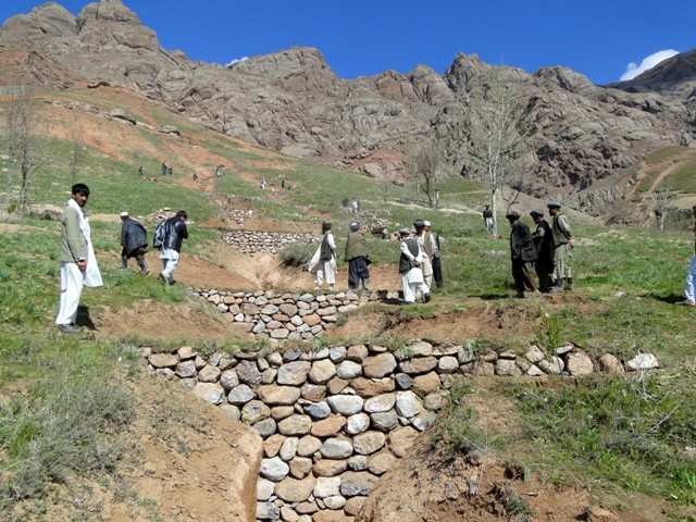
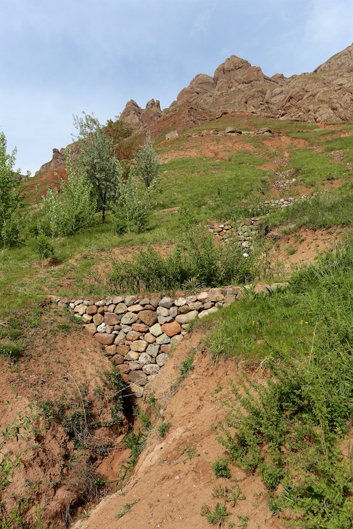
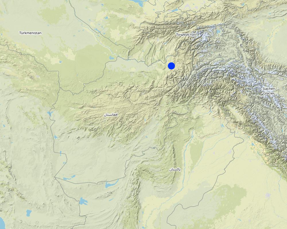
Project supported implementation of gully treatment has taken place in the villages Sari Joy and Jawaz Khana, located in Chokar watershed of Rustaq District in Northern Afghanistan. The Chokar watershed is a mountainous area situated between 600 m and 2,500 m above sea level. The climate is semi-arid with harsh and cold weather in winter and hot and dry summers. The annual precipitation in average years is 580 mm. Land degradation affects all forms of land use and includes sparse vegetation cover, severe topsoil erosion from water, and poor soil fertility. Unsustainable agricultural practices, together with over-exploitation and high pressure on the natural resources, are adversely impacting the socio-economic well-being of local communities, as well as contributing to the risk of being adversely affected by drought, and also leading to landslides and flash foods triggered by heavy rainfall. The data used for the documentation of the technology are based on field research conducted in Chokar watershed, namely in the villages of Sari Joy and Jawaz Khana. These villages represent the upper and the middle zone of Chokar watershed, respectively. They differ considerably in access to services and infrastructure, but in general are poorly served. The communities depend on land resources for sustaining their livelihoods. In a good year with high yields, wheat self-sufficiency lasts about 5 months. The villages are home to ethnic Qarluq communities. Since 2012 the Livelihood Improvement Project Takhar (LIPT) implemented by Terre des hommes (Tdh) Switzerland has initiated a range of NRM interventions.
The Livelihood Improvement Project in Takhar supported Natural Resources Management Committees to rehabilitate two gullies with check dams and trees in Sari Joy and Jawaz Khana. The check dams are made of stone walls built across the widest section of the gully. Jute bags filled with soil are used in the narrower sections of the gully to form a solid barrier for soil to accumulate. Tree seedlings and cuttings of Russian willow and acacia are planted between the check dams to stabilize the soil. During the first 2-3 years, the trees need to be protected from grazing, and from cutting for fuelwood. Watering of the trees may also be required during the dry season, especially in Jawaz Khana, to support their survival. Such methods of gully rehabilitation are feasible in the area, since the construction and planting materials are locally available. However, the costs for establishing the check dams remain relatively high and the local villages have contributed mainly with labour inputs, while the costs for construction material were provided by the project.
Check dams inside the gully slow the water flow and help its infiltration into the soil. The structures also collect sediment and reduce further erosion of the gully bed, and prevent its expansion in the area. Well managed check dams, after several years, can produce trees for fuelwood and grass for animal fodder.
Rehabilitation of gullies is an innovative practice for the local land users, but it is supported by the local communities for its visible impact on preventing further erosion and loss of community land used for crop cultivation, forest and orchards. After taking part in the design and implementation of rehabilitation activities, the local land users expressed that they had acquired useful skills and will be able to conduct these works independently if the material resources are available.
Women support the work by preparing and bringing food to the workers in the field. Women are also occasionally involved in filling the jute bags with soil and bring the bags to the gully. This requires significant inputs, bearing in mind that gullies are often formed in very steep areas where there are no roads - and thus the food and other material can be delivered only by foot or with a donkey.
2.3 Fotos da tecnologia
Galeria de Mídias
2.5 País/região/locais onde a tecnologia foi aplicada e que estão cobertos nesta avaliação
País:
Afeganistão
Região/Estado/Província:
Takhar Province, Rustaq District
Especificação adicional de localização:
Sari Joy and Jawaz Khana Villages
Comentários:
This documentation is based on the experiences of SLM implementers from Sari Joy (1 treated gully) and Jawaz Khana (1 treated gully).
Map
×2.6 Data da implementação
Caso o ano exato seja desconhecido, indique a data aproximada:
- menos de 10 anos atrás (recentemente)
2.7 Introdução da tecnologia
Especifique como a tecnologia foi introduzida:
- através de projetos/intervenções externas
Comentários (tipos de projeto, etc.):
Livelihood Improvement Project Takhar (LIPT) supported by Swiss Development Cooperation (SDC) from 2012-17.
3. Classificação da tecnologia de GST
3.1 Principal/principais finalidade(s) da tecnologia
- Reduz, previne, recupera a degradação do solo
- Protege uma bacia/zonas a jusante – em combinação com outra tecnologia
- Reduzir riscos de desastre
3.2 Tipo(s) atualizado(s) de uso da terra onde a tecnologia foi aplicada

Terra de cultivo
- Cultura anual
- Cultura perene (não lenhosa)

Misto (plantação, pastagem, árvores) inclusive agrofloresta
- Agrofloresta
- Silvipecuária
3.3 Mais informações sobre o uso da terra
Abastecimento de água para a terra na qual a tecnologia é aplicada:
- Misto de precipitação natural-irrigado
Número de estações de cultivo por ano:
- 1
3.4 Grupo de GST ao qual pertence a tecnologia
- Medidas de curva de nível
- Gestão de água de superfície (nascente, rio, lagos, mar)
3.5 Difusão da tecnologia
Especifique a difusão da tecnologia:
- Aplicado em pontos específicos/concentrado numa pequena área
3.6 Medidas de GST contendo a tecnologia

Medidas vegetativas
- V1: cobertura de árvores/arbustos

Medidas estruturais
- S6: Muros, barreiras, paliçadas, cercas
3.7 Principais tipos de degradação da terra abordados pela tecnologia

Erosão do solo pela água
- Wt: Perda do solo superficial/erosão de superfície
- Wg: Erosão por ravinas/ravinamento
- Wm: movimento de massas/deslizamentos
3.8 Redução, prevenção ou recuperação da degradação do solo
Especifique o objetivo da tecnologia em relação a degradação da terra:
- Reduzir a degradação do solo
- Recuperar/reabilitar solo severamente degradado
4. Especificações técnicas, implementação de atividades, entradas e custos
4.1 Desenho técnico da tecnologia
Autor:
Aslam Qadamov; Roziya Kirgizbekova
Data:
03/04/2017
4.2 Especificações técnicas/ explicações do desenho técnico
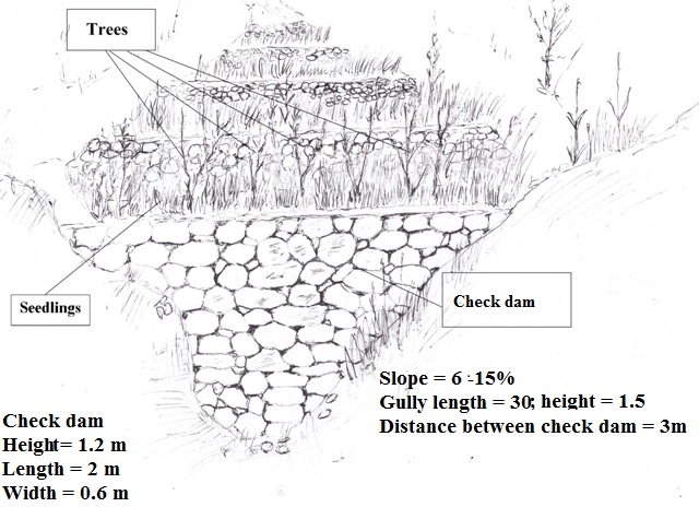
A check dam is a permanent structure across a gully. The size of the check dam and the spacing of check dams depends on the steepness of the slope and length of the gully. To rehabilitate a gully on a slope of 6 - 15 % steepness and 30 meters in length there are 10 check dams built inside the gully at a distance of 3 meters apart. The measurements of the check dam are: 1.2 m x 2 m x 0.6 m. The dam is built from stones or boulders either available locally or transported to the gully site. The upper part of the gully is planted with rows of tree cuttings (7 pieces) and saplings (3 pieces).
4.3 Informação geral em relação ao cálculo de entradas e custos
Especifique como custos e entradas foram calculados:
- Por unidade de tecnologia
Especifique a unidade:
gully
Especifique volume, comprimento, etc (se relevante):
30 meter length, 1,5 meter depth, 6-15% slope
Especifique a moeda utilizada para os cálculos de custo:
- Dólares norte-americanos
Indique a taxa cambial do dólar norte americano para a moeda local (se relevante): 1 USD =:
67,0
Indique a média salarial da mão-de-obra contratada por dia:
5.2-5.3 USD
4.4 Atividades de implantação
| Atividade | Tipo de medida | Periodicidade | |
|---|---|---|---|
| 1. | Design of the check dam | Estrutural | Winter |
| 2. | Digging the gully for preparation of construction work | Estrutural | Spring |
| 3. | Construction of the stone wall accross the gully | Estrutural | Spring |
| 4. | Filling the upper part of the stone wall with soil | Estrutural | Spring |
| 5. | Planting of tree seedlings and cuttings on upper part of the wall | Vegetativo | Spring |
4.5 Custos e entradas necessárias para a implantação
| Especifique a entrada | Unidade | Quantidade | Custos por unidade | Custos totais por entrada | % dos custos arcados pelos usuários da terra | |
|---|---|---|---|---|---|---|
| Mão-de-obra | Design of the check dam | person-day | 2,0 | 5,3 | 10,6 | |
| Mão-de-obra | Digging the gully for preparation of construction work | person-day | 8,0 | 5,3 | 42,4 | |
| Mão-de-obra | Construction of stone wall | person-day | 12,0 | 5,3 | 63,6 | |
| Mão-de-obra | Planting of tree seedlings and cuttings | person-day | 2,0 | 5,3 | 10,6 | 100,0 |
| Equipamento | Meter | piece | 1,0 | 2,2 | 2,2 | |
| Equipamento | Shovel | piece | 2,0 | 3,8 | 7,6 | |
| Equipamento | Axe | piece | 1,0 | 2,2 | 2,2 | |
| Equipamento | Wheelbarrow | piece | 1,0 | 38,0 | 38,0 | |
| Equipamento | Rope | meter | 100,0 | 0,07 | 7,0 | |
| Equipamento | Pick axe | piece | 1,0 | 3,0 | 3,0 | |
| Equipamento | Hammer | piece | 1,0 | 2,2 | 2,2 | |
| Material vegetal | Cuttings | piece | 100,0 | 0,37 | 37,0 | 50,0 |
| Material vegetal | Seedlings | piece | 10,0 | 0,6 | 6,0 | 50,0 |
| Material de construção | Stone | cubic meter | 6,0 | 7,49 | 44,94 | |
| Custos totais para a implantação da tecnologia | 277,34 | |||||
Se o usuário da terra arca com menos que 100% dos custos, indique quem cobre os custos remanescentes:
Livelihood Improvement Project Takhar (LIPT) implemented by Terre des hommes (Tdh) Switzerland
4.6 Atividades recorrentes/manutenção
| Atividade | Tipo de medida | Periodicidade/frequência | |
|---|---|---|---|
| 1. | Protecting the trees from animals | Gestão | Continious |
| 2. | Watering the trees | Vegetativo | During dry season |
4.7 Custos e entradas necessárias pata a manutenção/atividades recorrentes (por ano)
| Especifique a entrada | Unidade | Quantidade | Custos por unidade | Custos totais por entrada | % dos custos arcados pelos usuários da terra | |
|---|---|---|---|---|---|---|
| Mão-de-obra | Protecting the trees from animals | person day | 45,0 | 1,3 | 58,5 | 100,0 |
| Mão-de-obra | Watering the trees | person day | 10,0 | 5,3 | 53,0 | 100,0 |
| Custos totais para a manutenção da tecnologia | 111,5 | |||||
4.8 Fatores mais importantes que afetam os custos
Descreva os fatores mais determinantes que afetam os custos:
Due to the remoteness of the villages where the technology has been implemented, all the inputs for establishment, such as agricultural equipment, plant material, fertilizers, construction material, etc., are purchased in Rustaq town. The expenses for traveling and delivering the inputs affect the establishment costs.
5. Ambiente natural e humano
5.1 Clima
Precipitação pluviométrica anual
- <250 mm
- 251-500 mm
- 501-750 mm
- 751-1.000 mm
- 1.001-1.500 mm
- 1.501-2.000 mm
- 2.001-3.000 mm
- 3.001-4.000 mm
- > 4.000 mm
Especifique a média pluviométrica anual em mm (se conhecida):
564,00
Especificações/comentários sobre a pluviosidade:
Average annual precipitation for the area is 564 mm, with minimum in dry years (e.g. 2000 and 2001) of 270 mm and maximum in wet years (e.g. 2009 and 2010) of 830 mm. The data set shows an absolute maximum for annual rainfall for 1986, 1024 mm, and the absolute minimum for 2001, 269 mm. The data series covers the period from 1979 to 2014.
Indique o nome da estação meteorológica de referência considerada:
Climate Forecast System Reanalysis (CFSR), http://rda.ucar.edu/pub/cfsr.html
Zona agroclimática
- Semiárido
Derived from the publicly available dataset on length of growing period (LGP) (Fischer 2009 / IIASA-FAO). Internet link: http://tiles.arcgis.com/tiles/P8Cok4qAP1sTVE59/arcgis/rest/services/Length_of_growing_period/MapServer
5.2 Topografia
Declividade média:
- Plano (0-2%)
- Suave ondulado (3-5%)
- Ondulado (6-10%)
- Moderadamente ondulado (11-15%)
- Forte ondulado (16-30%)
- Montanhoso (31-60%)
- Escarpado (>60%)
Formas de relevo:
- Planalto/planície
- Cumes
- Encosta de serra
- Encosta de morro
- Sopés
- Fundos de vale
Zona de altitude:
- 0-100 m s.n.m.
- 101-500 m s.n.m.
- 501-1.000 m s.n.m.
- 1.001-1.500 m s.n.m.
- 1.501-2.000 m s.n.m.
- 2.001-2.500 m s.n.m.
- 2.501-3.000 m s.n.m.
- 3.001-4.000 m s.n.m.
- > 4.000 m s.n.m.
5.3 Solos
Profundidade do solo em média:
- Muito raso (0-20 cm)
- Raso (21-50 cm)
- Moderadamente profundo (51-80 cm)
- Profundo (81-120 cm)
- Muito profundo (>120 cm)
Textura do solo (solo superficial):
- Grosso/fino (arenoso)
- Médio (limoso, siltoso)
Textura do solo (>20 cm abaixo da superfície):
- Grosso/fino (arenoso)
- Médio (limoso, siltoso)
Matéria orgânica do solo superficial:
- Baixo (<1%)
Caso disponível anexe a descrição completa do solo ou especifique as informações disponíveis, p. ex. tipo de solo, PH/acidez do solo, nitrogênio, capacidade de troca catiônica, salinidade, etc.
Local land users differentiate between the following soil types where gully rehabilitation is implemented:
- Red: shallow; texture medium, coarse; low organic matter
- Light: moderately deep; texture medium; medium, low organic matter
5.4 Disponibilidade e qualidade de água
Lençol freático:
5-50 m
Disponibilidade de água de superfície:
Médio
Qualidade da água (não tratada):
Água potável boa
A salinidade da água é um problema?
Não
Ocorre inundação da área?
Sim
Regularidade:
Esporadicamente
Comentários e outras especificações sobre a qualidade e a quantidade da água:
Floods occur mainly during the rainy seasons in spring and autumn. Availability of surface water differs for the study villages Sari Joy and Jawaz Khana. Sari Joy has sources and good surface water availability. Jawaz Khana has poor water availability as water has to be fetched from a lower stream.
5.5 Biodiversidade
Diversidade de espécies:
- Baixo
Diversidade de habitat:
- Baixo
5.6 Características dos usuários da terra que utilizam a tecnologia
Sedentário ou nômade:
- Sedentário
Orientação de mercado do sistema de produção:
- Subsistência (autoabastecimento)
- Misto (subsistência/comercial)
Rendimento não agrícola:
- 10-50% de toda renda
- >50% de toda renda
Nível relativo de riqueza:
- Pobre
- Média
Indivíduos ou grupos:
- Grupos/comunidade
Nível de mecanização:
- Trabalho manual
- Tração animal
Gênero:
- Mulheres
- Homens
Idade dos usuários da terra:
- meia-idade
- idosos
Indique outras características relevantes dos usuários da terra:
The land users in the area where the Technology is applied belong to the Uzbek ethnic minority group Qarluq.
Although the men are generally the main land users, however, women and children also take active part in the related work. The functions of men and women are clearly distinguished within the Afghan society. At the same time within the family this division of work and functions also results in men and women working hand-in-hand. An improvement of the family’s livelihood situation is expected to positively affect all family members. While, it is recognized that the involvement of women is key in order to secure basic human rights for everyone, to achieve good governance, sustainable development, and to efficiently contribute to poverty reduction (SDC 2004), it is also clear that a context sensitive approach is of high importance.
Women in rural Afghanistan are involved in many production and income generating activities that contribute to the overall household income, however, very few women own resources such as land and livestock, and their income generating options are fewer in comparison to that of men.
5.7 Média da área de terra própria ou arrendada por usuários da terra que utilizam a tecnologia
- < 0,5 ha
- 0,5-1 ha
- 1-2 ha
- 2-5 ha
- 5-15 ha
- 15-50 ha
- 50-100 ha
- 100-500 ha
- 500-1.000 ha
- 1.000-10.000 ha
- > 10.000 ha
É considerado pequena, média ou grande escala (referente ao contexto local)?
- Média escala
5.8 Propriedade de terra, direitos de uso da terra e de uso da água
Propriedade da terra:
- Comunitário/rural
Direitos do uso da terra:
- Comunitário (organizado)
6. Impactos e declarações finais
6.1 Impactos no local mostrados pela tecnologia
Impactos socioeconômicos
Produção
Produção agrícola
Comentários/especificar:
Treatment of gullies on cropland, forest (mixed) land and grazing land protects the land from further erosion and protects the crop.
Produção de forragens
Produção animal
Diversidade de produtos
Área de produção
Comentários/especificar:
Through implementation of gully treatment the area that was lost to gully formation can be used for production purposes again.
Impactos ecológicos
Ciclo hídrico/escoamento
Escoamento superficial
Solo
Perda de solo
Biodiversidade: vegetação, animais
Cobertura vegetal
6.2 Impactos externos mostrados pela tecnologia
Cheias de jusante
Sedimentação a jusante
Capacidade de tamponamento/filtragem
Comentários relativos à avaliação de impacto:
Based on the Land User Protocols: Individual SLM implementers were asked to rate the benefits for their Technology. They were asked to indicate production increase of crops; fodder; animals; wood; non-wood forest products; increase in product diversity; or production area. The most important increase they rated with 3, the second most with 2, others with 1 point. Averages of the points given by all SLM implementers are reflected here.
Based on the Land User Protocols: Individual SLM implementers were asked to rate the on-site and off-site impacts of the Technology on water; soil; and vegetation. They were asked to indicate the strength of impacts with three, two or one points. Averages of the points given by all implementers are reflected here.
6.3 Exposição e sensibilidade da tecnologia às mudanças climáticas graduais e extremos/desastres relacionados ao clima (conforme o ponto de vista dos usuários da terra)
Extremos (desastres) relacionados ao clima
Desastres meteorológicos
| Como a tecnologia lida com isso? | |
|---|---|
| Temporal local | muito bem |
Desastres climatológicos
| Como a tecnologia lida com isso? | |
|---|---|
| Seca | bem |
Comentários:
SLM implementers from three villages were asked to jointly discuss and rate how much the SLM technology reduced the lands vulnerability to drought and local rainstorms. Only vulnerability to the most prevalent climate extremes (drought and local rainstorms) was discussed. SLM technologies were rated as reducing vulnerability poorly , well, or very well. The average points reflected here are from multi-criteria matrices compiled in three villages where the SLM technology had been implemented.
6.4 Análise do custo-benefício
Como os benefícios se comparam aos custos de implantação (do ponto de vista dos usuários da terra)?
Retornos a curto prazo:
muito positivo
Retornos a longo prazo:
muito positivo
Comentários:
SLM implementers from three villages were asked to jointly discuss and rate the SLM technologies short term (1-3 years) and long-term (10 years) return. As most of the technologies have only been implemented 1-2 years ago, it is too early to compare benefits to maintenance costs. Farmers have little experience so far on the actual benefits of the SLM technologies. The ratings are mostly based on expected benefits and not on actual benefits.
6.5 Adoção da tecnologia
- 1-10%
Se disponível, determine a quantidade (número de unidades familiares e/ou área abordada):
2 households
Entre todos aqueles que adotaram a tecnologia, quantos adotaram espontaneamente, ou seja, sem receber nenhum incentivo material/pagamentos?
- 0-10%
Comentários:
2 land users replicated the technology without receiving financial support.
6.6 Adaptação
A tecnologia foi recentemente modificada para adaptar-se as condições variáveis?
Não
6.7 Pontos fortes/vantagens/oportunidades da tecnologia
| Pontos fortes/vantagens/oportunidades na visão do usuário da terra |
|---|
| Through the technology implementation expansion of the gully is halted and loss of land is prevented. |
| The land is less vulnerable to heavy rainfall. Agricultural land, houses and local infrastructure are protected from flood damage during the rainy season. |
| The grass which grows on the rehabilitated gullies can be used for livestock fodder. |
| Pontos fortes/vantagens/oportunidades na visão do/a compilador/a ou de outra pessoa capacitada |
|---|
| Expansion of the production area to be used for cultivation or reforestation in a long-term perspective |
6.8 Pontos fracos, desvantagens/riscos da tecnologia e formas de superá-los
| Pontos fracos/desvantagens/riscos na visão do usuário da terra | Como eles podem ser superados? |
|---|---|
| Requires significant resources to cover all the costs for establishment | |
| Establishment of check dams is highly labour intensive |
| Pontos fracos/vantagens/riscos na visão do/a compilador/a ou de outra pessoa capacitada | Como eles podem ser superados? |
|---|---|
| Requires continuous maintenance to prevent damage to the constructed check dams. Protection of the trees from grazing and illegal logging is needed. | |
| Technical knowledge and support is required to design and construct the gullies in accordance with local conditions and available material |
7. Referências e links
7.1 Métodos/fontes de informação
- visitas de campo, pesquisas de campo
No field visits were conducted.
- entrevistas com usuários de terras
Focus group discussions (FGD) were organized by the CDE team to collect information from SLM implementers. 3 land users who have implemented the technology participated in the FGDs held in Sari Joy and Jawaz Khana.
Interviews were conducted by the HAFL team to collect information from persons representing the study villages. Very detailed interviews were conducted with 40 persons interested in terrace implementation, of which 17 persons are from households that already have implemented terraces.
- entrevistas com especialistas em GST
Close collaboration took place during the compilation of this material with the technical staff of the LIPT project in Rustaq.
- compilação de relatórios e outra documentação existente
Information provided in the reports of the LIPT project in Rustaq served as an initial source of information during the preparatory phase and also solidifying the description of the technology and area of implementation. Other background papers on Afghanistan were referred to for general information on agriculture and natural resource management in Afghanistan.
7.2 Referências às publicações disponíveis
Título, autor, ano, ISBN:
Guidelines for Focus Groups Discussions
Título, autor, ano, ISBN:
Methods section of the Rustaq NRM study
Links e módulos
Expandir tudo Recolher tudoLinks
Não há links
Módulos
Não há módulos