Gully treatment [Afghanistan]
- Création :
- Mise à jour :
- Compilateur : Bettina Wolfgramm
- Rédacteurs : Reto Zehnder, Roziya Kirgizbekova, Aslam Qadamov
- Examinateur : William Critchley
Check dam
technologies_542 - Afghanistan
Voir les sections
Développer tout Réduire tout1. Informations générales
1.2 Coordonnées des personnes-ressources et des institutions impliquées dans l'évaluation et la documentation de la Technologie
Personne(s)-ressource(s) clé(s)
exploitant des terres:
Mohammad Azim Habibullah
Natural Resources Management Comittee (NRMC)
Sari Joy Village, Takhar Province
Afghanistan
Spécialiste GDT:
Spécialiste GDT:
Researcher:
Nom du projet qui a facilité la documentation/ l'évaluation de la Technologie (si pertinent)
Potential and limitations for improved natural resource management (NRM) in mountain communities in the Rustaq district, Afghanistan (Rustaq NRM Study)Nom du projet qui a facilité la documentation/ l'évaluation de la Technologie (si pertinent)
Livelihood Improvement Project Takhar, Afghanistan (LIPT)Nom du ou des institutions qui ont facilité la documentation/ l'évaluation de la Technologie (si pertinent)
Terre des Hommes (Terre des Hommes) - SuisseNom du ou des institutions qui ont facilité la documentation/ l'évaluation de la Technologie (si pertinent)
Swiss Agency for Development and Cooperation (DEZA / COSUDE / DDC / SDC) - SuisseNom du ou des institutions qui ont facilité la documentation/ l'évaluation de la Technologie (si pertinent)
CDE Centre for Development and Environment (CDE Centre for Development and Environment) - SuisseNom du ou des institutions qui ont facilité la documentation/ l'évaluation de la Technologie (si pertinent)
Bern University of Applied Sciences, School of Agricultural, Forest and Food Sciences (HAFL) - Suisse1.3 Conditions relatives à l'utilisation par WOCAT des données documentées
Quand les données ont-elles été compilées (sur le terrain)?
17/10/2016
Le compilateur et la(les) personne(s) ressource(s) acceptent les conditions relatives à l'utilisation par WOCAT des données documentées:
Oui
1.4 Déclaration sur la durabilité de la Technologie décrite
Est-ce que la Technologie décrite ici pose problème par rapport à la dégradation des terres, de telle sorte qu'elle ne peut pas être déclarée comme étant une technologie de gestion durable des terres?
Non
Commentaires:
SLM practices documented in the frame of the Rustaq NRM study were established only recently (1-3 years ago). It is too early for a final judgment on the sustainability of these technologies within the human and natural environment of Chokar watershed.
2. Description de la Technologie de GDT
2.1 Courte description de la Technologie
Définition de la Technologie:
Small check dams made of stone, together with planting of trees, slow water flow and reduce further erosion in a gully, leading to its restoration.
2.2 Description détaillée de la Technologie
Description:
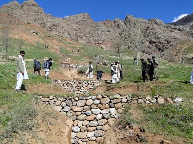
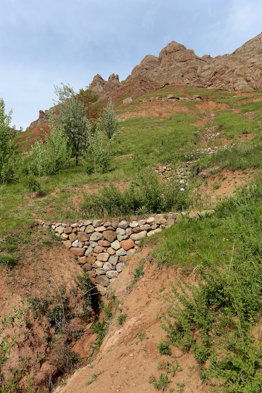
Project supported implementation of gully treatment has taken place in the villages Sari Joy and Jawaz Khana, located in Chokar watershed of Rustaq District in Northern Afghanistan. The Chokar watershed is a mountainous area situated between 600 m and 2,500 m above sea level. The climate is semi-arid with harsh and cold weather in winter and hot and dry summers. The annual precipitation in average years is 580 mm. Land degradation affects all forms of land use and includes sparse vegetation cover, severe topsoil erosion from water, and poor soil fertility. Unsustainable agricultural practices, together with over-exploitation and high pressure on the natural resources, are adversely impacting the socio-economic well-being of local communities, as well as contributing to the risk of being adversely affected by drought, and also leading to landslides and flash foods triggered by heavy rainfall. The data used for the documentation of the technology are based on field research conducted in Chokar watershed, namely in the villages of Sari Joy and Jawaz Khana. These villages represent the upper and the middle zone of Chokar watershed, respectively. They differ considerably in access to services and infrastructure, but in general are poorly served. The communities depend on land resources for sustaining their livelihoods. In a good year with high yields, wheat self-sufficiency lasts about 5 months. The villages are home to ethnic Qarluq communities. Since 2012 the Livelihood Improvement Project Takhar (LIPT) implemented by Terre des hommes (Tdh) Switzerland has initiated a range of NRM interventions.
The Livelihood Improvement Project in Takhar supported Natural Resources Management Committees to rehabilitate two gullies with check dams and trees in Sari Joy and Jawaz Khana. The check dams are made of stone walls built across the widest section of the gully. Jute bags filled with soil are used in the narrower sections of the gully to form a solid barrier for soil to accumulate. Tree seedlings and cuttings of Russian willow and acacia are planted between the check dams to stabilize the soil. During the first 2-3 years, the trees need to be protected from grazing, and from cutting for fuelwood. Watering of the trees may also be required during the dry season, especially in Jawaz Khana, to support their survival. Such methods of gully rehabilitation are feasible in the area, since the construction and planting materials are locally available. However, the costs for establishing the check dams remain relatively high and the local villages have contributed mainly with labour inputs, while the costs for construction material were provided by the project.
Check dams inside the gully slow the water flow and help its infiltration into the soil. The structures also collect sediment and reduce further erosion of the gully bed, and prevent its expansion in the area. Well managed check dams, after several years, can produce trees for fuelwood and grass for animal fodder.
Rehabilitation of gullies is an innovative practice for the local land users, but it is supported by the local communities for its visible impact on preventing further erosion and loss of community land used for crop cultivation, forest and orchards. After taking part in the design and implementation of rehabilitation activities, the local land users expressed that they had acquired useful skills and will be able to conduct these works independently if the material resources are available.
Women support the work by preparing and bringing food to the workers in the field. Women are also occasionally involved in filling the jute bags with soil and bring the bags to the gully. This requires significant inputs, bearing in mind that gullies are often formed in very steep areas where there are no roads - and thus the food and other material can be delivered only by foot or with a donkey.
2.3 Photos de la Technologie
Galerie Médias
2.5 Pays/ région/ lieux où la Technologie a été appliquée et qui sont couverts par cette évaluation
Pays:
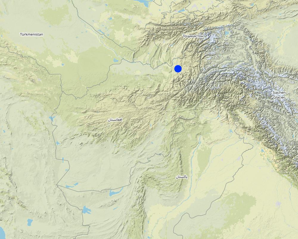
Afghanistan
Région/ Etat/ Province:
Takhar Province, Rustaq District
Autres spécifications du lieu:
Sari Joy and Jawaz Khana Villages
Commentaires:
This documentation is based on the experiences of SLM implementers from Sari Joy (1 treated gully) and Jawaz Khana (1 treated gully).
Map
×2.6 Date de mise en œuvre de la Technologie
Si l'année précise est inconnue, indiquez la date approximative: :
- il y a moins de 10 ans (récemment)
2.7 Introduction de la Technologie
Spécifiez comment la Technologie a été introduite: :
- par le biais de projets/ d'interventions extérieures
Commentaires (type de projet, etc.) :
Livelihood Improvement Project Takhar (LIPT) supported by Swiss Development Cooperation (SDC) from 2012-17.
3. Classification de la Technologie de GDT
3.1 Principal(aux) objectif(s) de la Technologie
- réduire, prévenir, restaurer les terres dégradées
- protéger un bassin versant/ des zones situées en aval - en combinaison avec d'autres technologies
- réduire les risques de catastrophes
3.2 Type(s) actuel(s) d'utilisation des terres, là où la Technologie est appliquée

Terres cultivées
- Cultures annuelles
- Cultures pérennes (non ligneuses)

Mixte (cultures/ pâturages/ arbres), incluant l'agroforesterie
- Agroforesterie
- Sylvo-pastoralisme
3.3 Informations complémentaires sur l'utilisation des terres
Approvisionnement en eau des terres sur lesquelles est appliquée la Technologie:
- mixte: pluvial-irrigué
Nombre de période de croissance par an: :
- 1
3.4 Groupe de GDT auquel appartient la Technologie
- mesures en travers de la pente
- gestion des eaux de surface (sources, rivières, lacs, mers)
3.5 Diffusion de la Technologie
Spécifiez la diffusion de la Technologie:
- appliquée en des points spécifiques ou concentrée sur une petite surface
3.6 Mesures de GDT constituant la Technologie

pratiques végétales
- V1: Couverture d’arbres et d’arbustes

structures physiques
- S6: Murs, barrières, palissades, clôtures
3.7 Principaux types de dégradation des terres traités par la Technologie

érosion hydrique des sols
- Wt: perte de la couche superficielle des sols (couche arable)/ érosion de surface
- Wg: ravinement/ érosion en ravines
- Wm: mouvements de masse/ glissements de terrain
3.8 Prévention, réduction de la dégradation ou réhabilitation des terres dégradées
Spécifiez l'objectif de la Technologie au regard de la dégradation des terres:
- réduire la dégradation des terres
- restaurer/ réhabiliter des terres sévèrement dégradées
4. Spécifications techniques, activités, intrants et coûts de mise en œuvre
4.1 Dessin technique de la Technologie
Auteur:
Aslam Qadamov; Roziya Kirgizbekova
Date:
03/04/2017
4.2 Spécification/ explications techniques du dessin technique
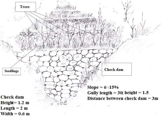
A check dam is a permanent structure across a gully. The size of the check dam and the spacing of check dams depends on the steepness of the slope and length of the gully. To rehabilitate a gully on a slope of 6 - 15 % steepness and 30 meters in length there are 10 check dams built inside the gully at a distance of 3 meters apart. The measurements of the check dam are: 1.2 m x 2 m x 0.6 m. The dam is built from stones or boulders either available locally or transported to the gully site. The upper part of the gully is planted with rows of tree cuttings (7 pieces) and saplings (3 pieces).
4.3 Informations générales sur le calcul des intrants et des coûts
Spécifiez la manière dont les coûts et les intrants ont été calculés:
- par entité de la Technologie
Précisez l'unité:
gully
Spécifiez le volume, la longueur, etc. (si pertinent):
30 meter length, 1,5 meter depth, 6-15% slope
Indiquez la monnaie utilisée pour le calcul des coûts:
- dollars US
Indiquer le taux de change du dollars en monnaie locale (si pertinent): 1 USD= :
67,0
Indiquez le coût salarial moyen de la main d'œuvre par jour:
5.2-5.3 USD
4.4 Activités de mise en place/ d'établissement
| Activité | Type de mesures | Calendrier | |
|---|---|---|---|
| 1. | Design of the check dam | Structurel | Winter |
| 2. | Digging the gully for preparation of construction work | Structurel | Spring |
| 3. | Construction of the stone wall accross the gully | Structurel | Spring |
| 4. | Filling the upper part of the stone wall with soil | Structurel | Spring |
| 5. | Planting of tree seedlings and cuttings on upper part of the wall | Végétale | Spring |
4.5 Coûts et intrants nécessaires à la mise en place
| Spécifiez les intrants | Unité | Quantité | Coûts par unité | Coût total par intrant | % des coût supporté par les exploitants des terres | |
|---|---|---|---|---|---|---|
| Main d'œuvre | Design of the check dam | person-day | 2,0 | 5,3 | 10,6 | |
| Main d'œuvre | Digging the gully for preparation of construction work | person-day | 8,0 | 5,3 | 42,4 | |
| Main d'œuvre | Construction of stone wall | person-day | 12,0 | 5,3 | 63,6 | |
| Main d'œuvre | Planting of tree seedlings and cuttings | person-day | 2,0 | 5,3 | 10,6 | 100,0 |
| Equipements | Meter | piece | 1,0 | 2,2 | 2,2 | |
| Equipements | Shovel | piece | 2,0 | 3,8 | 7,6 | |
| Equipements | Axe | piece | 1,0 | 2,2 | 2,2 | |
| Equipements | Wheelbarrow | piece | 1,0 | 38,0 | 38,0 | |
| Equipements | Rope | meter | 100,0 | 0,07 | 7,0 | |
| Equipements | Pick axe | piece | 1,0 | 3,0 | 3,0 | |
| Equipements | Hammer | piece | 1,0 | 2,2 | 2,2 | |
| Matériel végétal | Cuttings | piece | 100,0 | 0,37 | 37,0 | 50,0 |
| Matériel végétal | Seedlings | piece | 10,0 | 0,6 | 6,0 | 50,0 |
| Matériaux de construction | Stone | cubic meter | 6,0 | 7,49 | 44,94 | |
| Coût total de mise en place de la Technologie | 277,34 | |||||
Si le coût n'est pas pris en charge à 100% par l'exploitant des terres, indiquez qui a financé le coût restant:
Livelihood Improvement Project Takhar (LIPT) implemented by Terre des hommes (Tdh) Switzerland
4.6 Activités d'entretien/ récurrentes
| Activité | Type de mesures | Calendrier/ fréquence | |
|---|---|---|---|
| 1. | Protecting the trees from animals | Modes de gestion | Continious |
| 2. | Watering the trees | Végétale | During dry season |
4.7 Coûts et intrants nécessaires aux activités d'entretien/ récurrentes (par an)
| Spécifiez les intrants | Unité | Quantité | Coûts par unité | Coût total par intrant | % des coût supporté par les exploitants des terres | |
|---|---|---|---|---|---|---|
| Main d'œuvre | Protecting the trees from animals | person day | 45,0 | 1,3 | 58,5 | 100,0 |
| Main d'œuvre | Watering the trees | person day | 10,0 | 5,3 | 53,0 | 100,0 |
| Coût total d'entretien de la Technologie | 111,5 | |||||
4.8 Facteurs les plus importants affectant les coûts
Décrivez les facteurs les plus importants affectant les coûts :
Due to the remoteness of the villages where the technology has been implemented, all the inputs for establishment, such as agricultural equipment, plant material, fertilizers, construction material, etc., are purchased in Rustaq town. The expenses for traveling and delivering the inputs affect the establishment costs.
5. Environnement naturel et humain
5.1 Climat
Précipitations annuelles
- < 250 mm
- 251-500 mm
- 501-750 mm
- 751-1000 mm
- 1001-1500 mm
- 1501-2000 mm
- 2001-3000 mm
- 3001-4000 mm
- > 4000 mm
Spécifiez la pluviométrie moyenne annuelle (si connue), en mm:
564,00
Spécifications/ commentaires sur les précipitations:
Average annual precipitation for the area is 564 mm, with minimum in dry years (e.g. 2000 and 2001) of 270 mm and maximum in wet years (e.g. 2009 and 2010) of 830 mm. The data set shows an absolute maximum for annual rainfall for 1986, 1024 mm, and the absolute minimum for 2001, 269 mm. The data series covers the period from 1979 to 2014.
Indiquez le nom de la station météorologique de référence considérée:
Climate Forecast System Reanalysis (CFSR), http://rda.ucar.edu/pub/cfsr.html
Zone agro-climatique
- semi-aride
Derived from the publicly available dataset on length of growing period (LGP) (Fischer 2009 / IIASA-FAO). Internet link: http://tiles.arcgis.com/tiles/P8Cok4qAP1sTVE59/arcgis/rest/services/Length_of_growing_period/MapServer
5.2 Topographie
Pentes moyennes:
- plat (0-2 %)
- faible (3-5%)
- modéré (6-10%)
- onduleux (11-15%)
- vallonné (16-30%)
- raide (31-60%)
- très raide (>60%)
Reliefs:
- plateaux/ plaines
- crêtes
- flancs/ pentes de montagne
- flancs/ pentes de colline
- piémonts/ glacis (bas de pente)
- fonds de vallée/bas-fonds
Zones altitudinales:
- 0-100 m
- 101-500 m
- 501-1000 m
- 1001-1500 m
- 1501-2000 m
- 2001-2500 m
- 2501-3000 m
- 3001-4000 m
- > 4000 m
5.3 Sols
Profondeur moyenne du sol:
- très superficiel (0-20 cm)
- superficiel (21-50 cm)
- modérément profond (51-80 cm)
- profond (81-120 cm)
- très profond (>120 cm)
Texture du sol (de la couche arable):
- grossier/ léger (sablonneux)
- moyen (limoneux)
Texture du sol (> 20 cm sous la surface):
- grossier/ léger (sablonneux)
- moyen (limoneux)
Matière organique de la couche arable:
- faible (<1%)
Si disponible, joignez une description complète du sol ou précisez les informations disponibles, par ex., type de sol, pH/ acidité du sol, capacité d'échange cationique, azote, salinité, etc.
Local land users differentiate between the following soil types where gully rehabilitation is implemented:
- Red: shallow; texture medium, coarse; low organic matter
- Light: moderately deep; texture medium; medium, low organic matter
5.4 Disponibilité et qualité de l'eau
Profondeur estimée de l’eau dans le sol:
5-50 m
Disponibilité de l’eau de surface:
moyenne
Qualité de l’eau (non traitée):
eau potable
La salinité de l'eau est-elle un problème? :
Non
La zone est-elle inondée?
Oui
Régularité:
épisodiquement
Commentaires et précisions supplémentaires sur la qualité et la quantité d'eau:
Floods occur mainly during the rainy seasons in spring and autumn. Availability of surface water differs for the study villages Sari Joy and Jawaz Khana. Sari Joy has sources and good surface water availability. Jawaz Khana has poor water availability as water has to be fetched from a lower stream.
5.5 Biodiversité
Diversité des espèces:
- faible
Diversité des habitats:
- faible
5.6 Caractéristiques des exploitants des terres appliquant la Technologie
Sédentaire ou nomade:
- Sédentaire
Orientation du système de production:
- subsistance (auto-approvisionnement)
- mixte (de subsistance/ commercial)
Revenus hors exploitation:
- 10-50% de tous les revenus
- > 50% de tous les revenus
Niveau relatif de richesse:
- pauvre
- moyen
Individus ou groupes:
- groupe/ communauté
Niveau de mécanisation:
- travail manuel
- traction animale
Genre:
- femmes
- hommes
Age des exploitants des terres:
- personnes d'âge moyen
- personnes âgées
Indiquez toute autre caractéristique pertinente des exploitants des terres:
The land users in the area where the Technology is applied belong to the Uzbek ethnic minority group Qarluq.
Although the men are generally the main land users, however, women and children also take active part in the related work. The functions of men and women are clearly distinguished within the Afghan society. At the same time within the family this division of work and functions also results in men and women working hand-in-hand. An improvement of the family’s livelihood situation is expected to positively affect all family members. While, it is recognized that the involvement of women is key in order to secure basic human rights for everyone, to achieve good governance, sustainable development, and to efficiently contribute to poverty reduction (SDC 2004), it is also clear that a context sensitive approach is of high importance.
Women in rural Afghanistan are involved in many production and income generating activities that contribute to the overall household income, however, very few women own resources such as land and livestock, and their income generating options are fewer in comparison to that of men.
5.7 Superficie moyenne des terres détenues ou louées par les exploitants appliquant la Technologie
- < 0,5 ha
- 0,5-1 ha
- 1-2 ha
- 2-5 ha
- 5-15 ha
- 15-50 ha
- 50-100 ha
- 100-500 ha
- 500-1 000 ha
- 1 000-10 000 ha
- > 10 000 ha
Cette superficie est-elle considérée comme de petite, moyenne ou grande dimension (en se référant au contexte local)?
- moyenne dimension
5.8 Propriété foncière, droits d’utilisation des terres et de l'eau
Propriété foncière:
- communauté/ village
Droits d’utilisation des terres:
- communautaire (organisé)
6. Impacts et conclusions
6.1 Impacts sur site que la Technologie a montrés
Impacts socio-économiques
Production
production agricole
Commentaires/ spécifiez:
Treatment of gullies on cropland, forest (mixed) land and grazing land protects the land from further erosion and protects the crop.
production fourragère
production animale
diversité des produits
surface de production
Commentaires/ spécifiez:
Through implementation of gully treatment the area that was lost to gully formation can be used for production purposes again.
Impacts écologiques
Cycle de l'eau/ ruissellement
ruissellement de surface
Sols
perte en sol
Biodiversité: végétale, animale
Couverture végétale
6.2 Impacts hors site que la Technologie a montrés
inondations en aval
envasement en aval
capacité tampon/de filtration
Commentaires concernant l'évaluation des impacts:
Based on the Land User Protocols: Individual SLM implementers were asked to rate the benefits for their Technology. They were asked to indicate production increase of crops; fodder; animals; wood; non-wood forest products; increase in product diversity; or production area. The most important increase they rated with 3, the second most with 2, others with 1 point. Averages of the points given by all SLM implementers are reflected here.
Based on the Land User Protocols: Individual SLM implementers were asked to rate the on-site and off-site impacts of the Technology on water; soil; and vegetation. They were asked to indicate the strength of impacts with three, two or one points. Averages of the points given by all implementers are reflected here.
6.3 Exposition et sensibilité de la Technologie aux changements progressifs et aux évènements extrêmes/catastrophes liés au climat (telles que perçues par les exploitants des terres)
Extrêmes climatiques (catastrophes)
Catastrophes météorologiques
| Comment la Technologie fait-elle face à cela? | |
|---|---|
| pluie torrentielle locale | très bien |
Catastrophes climatiques
| Comment la Technologie fait-elle face à cela? | |
|---|---|
| sécheresse | bien |
Commentaires:
SLM implementers from three villages were asked to jointly discuss and rate how much the SLM technology reduced the lands vulnerability to drought and local rainstorms. Only vulnerability to the most prevalent climate extremes (drought and local rainstorms) was discussed. SLM technologies were rated as reducing vulnerability poorly , well, or very well. The average points reflected here are from multi-criteria matrices compiled in three villages where the SLM technology had been implemented.
6.4 Analyse coûts-bénéfices
Quels sont les bénéfices comparativement aux coûts de mise en place (du point de vue des exploitants des terres)?
Rentabilité à court terme:
très positive
Rentabilité à long terme:
très positive
Commentaires:
SLM implementers from three villages were asked to jointly discuss and rate the SLM technologies short term (1-3 years) and long-term (10 years) return. As most of the technologies have only been implemented 1-2 years ago, it is too early to compare benefits to maintenance costs. Farmers have little experience so far on the actual benefits of the SLM technologies. The ratings are mostly based on expected benefits and not on actual benefits.
6.5 Adoption de la Technologie
- 1-10%
Si disponible, quantifiez (nombre de ménages et/ou superficie couverte):
2 households
Parmi tous ceux qui ont adopté la Technologie, combien d'entre eux l'ont fait spontanément, à savoir sans recevoir aucune incitation matérielle ou aucun paiement?
- 0-10%
Commentaires:
2 land users replicated the technology without receiving financial support.
6.6 Adaptation
La Technologie a-t-elle été récemment modifiée pour s'adapter à l'évolution des conditions?
Non
6.7 Points forts/ avantages/ possibilités de la Technologie
| Points forts/ avantages/ possibilités du point de vue de l'exploitant des terres |
|---|
| Through the technology implementation expansion of the gully is halted and loss of land is prevented. |
| The land is less vulnerable to heavy rainfall. Agricultural land, houses and local infrastructure are protected from flood damage during the rainy season. |
| The grass which grows on the rehabilitated gullies can be used for livestock fodder. |
| Points forts/ avantages/ possibilités du point de vue du compilateur ou d'une autre personne ressource clé |
|---|
| Expansion of the production area to be used for cultivation or reforestation in a long-term perspective |
6.8 Faiblesses/ inconvénients/ risques de la Technologie et moyens de les surmonter
| Faiblesses/ inconvénients/ risques du point de vue de l’exploitant des terres | Comment peuvent-ils être surmontés? |
|---|---|
| Requires significant resources to cover all the costs for establishment | |
| Establishment of check dams is highly labour intensive |
| Faiblesses/ inconvénients/ risques du point de vue du compilateur ou d'une autre personne ressource clé | Comment peuvent-ils être surmontés? |
|---|---|
| Requires continuous maintenance to prevent damage to the constructed check dams. Protection of the trees from grazing and illegal logging is needed. | |
| Technical knowledge and support is required to design and construct the gullies in accordance with local conditions and available material |
7. Références et liens
7.1 Méthodes/ sources d'information
- visites de terrain, enquêtes sur le terrain
No field visits were conducted.
- interviews/entretiens avec les exploitants des terres
Focus group discussions (FGD) were organized by the CDE team to collect information from SLM implementers. 3 land users who have implemented the technology participated in the FGDs held in Sari Joy and Jawaz Khana.
Interviews were conducted by the HAFL team to collect information from persons representing the study villages. Very detailed interviews were conducted with 40 persons interested in terrace implementation, of which 17 persons are from households that already have implemented terraces.
- interviews/ entretiens avec les spécialistes/ experts de GDT
Close collaboration took place during the compilation of this material with the technical staff of the LIPT project in Rustaq.
- compilation à partir de rapports et d'autres documents existants
Information provided in the reports of the LIPT project in Rustaq served as an initial source of information during the preparatory phase and also solidifying the description of the technology and area of implementation. Other background papers on Afghanistan were referred to for general information on agriculture and natural resource management in Afghanistan.
7.2 Références des publications disponibles
Titre, auteur, année, ISBN:
Guidelines for Focus Groups Discussions
Titre, auteur, année, ISBN:
Methods section of the Rustaq NRM study
Liens et modules
Développer tout Réduire toutLiens
Aucun lien
Modules
Aucun module trouvé