Gully treatment [阿富汗]
- 创建:
- 更新:
- 编制者: Bettina Wolfgramm
- 编辑者: Reto Zehnder, Roziya Kirgizbekova, Aslam Qadamov
- 审查者: William Critchley
Check dam
technologies_542 - 阿富汗
查看章节
全部展开 全部收起1. 一般信息
1.2 参与该技术评估和文件编制的资源人员和机构的联系方式
关键资源人
土地使用者:
Mohammad Azim Habibullah
Natural Resources Management Comittee (NRMC)
Sari Joy Village, Takhar Province
阿富汗
SLM专业人员:
SLM专业人员:
Researcher:
有助于对技术进行记录/评估的项目名称(如相关)
Potential and limitations for improved natural resource management (NRM) in mountain communities in the Rustaq district, Afghanistan (Rustaq NRM Study)有助于对技术进行记录/评估的项目名称(如相关)
Livelihood Improvement Project Takhar, Afghanistan (LIPT)有助于对技术进行记录/评估的机构名称(如相关)
Terre des Hommes (Terre des Hommes) - 瑞士有助于对技术进行记录/评估的机构名称(如相关)
Swiss Agency for Development and Cooperation (DEZA / COSUDE / DDC / SDC) - 瑞士有助于对技术进行记录/评估的机构名称(如相关)
CDE Centre for Development and Environment (CDE Centre for Development and Environment) - 瑞士有助于对技术进行记录/评估的机构名称(如相关)
Bern University of Applied Sciences, School of Agricultural, Forest and Food Sciences (HAFL) - 瑞士1.3 关于使用通过WOCAT记录的数据的条件
(现场)数据是什么时候汇编的?:
17/10/2016
编制者和关键资源人员接受有关使用通过WOCAT记录数据的条件。:
是
1.4 所述技术的可持续性声明
这里所描述的技术在土地退化方面是否存在问题,导致无法被认为是一种可持续的土地管理技术?:
否
注释:
SLM practices documented in the frame of the Rustaq NRM study were established only recently (1-3 years ago). It is too early for a final judgment on the sustainability of these technologies within the human and natural environment of Chokar watershed.
2. SLM技术的说明
2.1 技术简介
技术定义:
Small check dams made of stone, together with planting of trees, slow water flow and reduce further erosion in a gully, leading to its restoration.
2.2 技术的详细说明
说明:
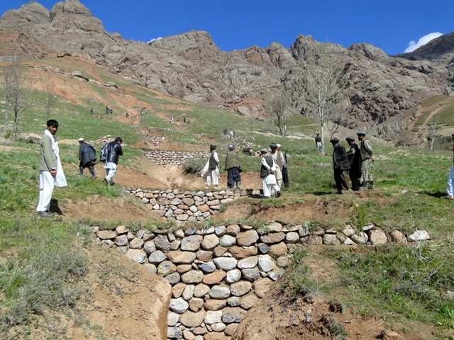
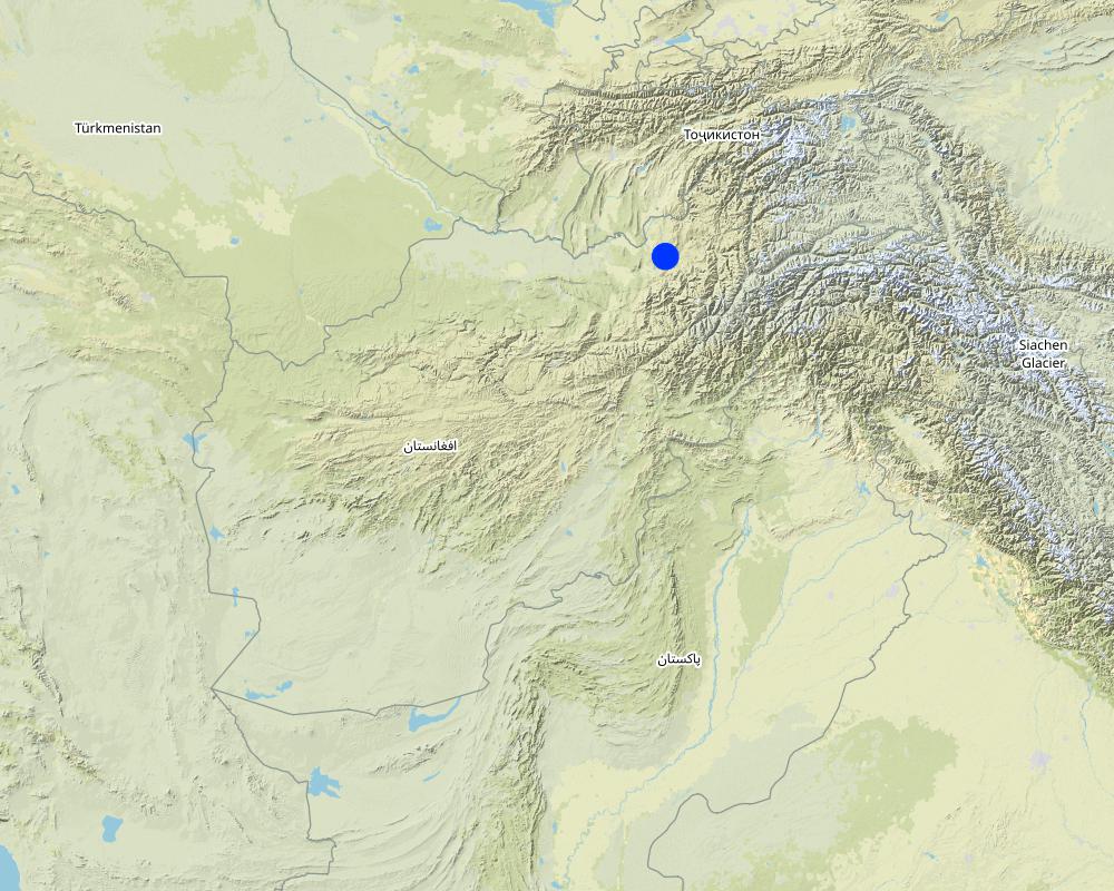
Project supported implementation of gully treatment has taken place in the villages Sari Joy and Jawaz Khana, located in Chokar watershed of Rustaq District in Northern Afghanistan. The Chokar watershed is a mountainous area situated between 600 m and 2,500 m above sea level. The climate is semi-arid with harsh and cold weather in winter and hot and dry summers. The annual precipitation in average years is 580 mm. Land degradation affects all forms of land use and includes sparse vegetation cover, severe topsoil erosion from water, and poor soil fertility. Unsustainable agricultural practices, together with over-exploitation and high pressure on the natural resources, are adversely impacting the socio-economic well-being of local communities, as well as contributing to the risk of being adversely affected by drought, and also leading to landslides and flash foods triggered by heavy rainfall. The data used for the documentation of the technology are based on field research conducted in Chokar watershed, namely in the villages of Sari Joy and Jawaz Khana. These villages represent the upper and the middle zone of Chokar watershed, respectively. They differ considerably in access to services and infrastructure, but in general are poorly served. The communities depend on land resources for sustaining their livelihoods. In a good year with high yields, wheat self-sufficiency lasts about 5 months. The villages are home to ethnic Qarluq communities. Since 2012 the Livelihood Improvement Project Takhar (LIPT) implemented by Terre des hommes (Tdh) Switzerland has initiated a range of NRM interventions.
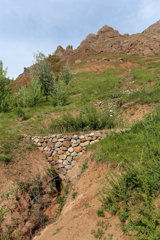
The Livelihood Improvement Project in Takhar supported Natural Resources Management Committees to rehabilitate two gullies with check dams and trees in Sari Joy and Jawaz Khana. The check dams are made of stone walls built across the widest section of the gully. Jute bags filled with soil are used in the narrower sections of the gully to form a solid barrier for soil to accumulate. Tree seedlings and cuttings of Russian willow and acacia are planted between the check dams to stabilize the soil. During the first 2-3 years, the trees need to be protected from grazing, and from cutting for fuelwood. Watering of the trees may also be required during the dry season, especially in Jawaz Khana, to support their survival. Such methods of gully rehabilitation are feasible in the area, since the construction and planting materials are locally available. However, the costs for establishing the check dams remain relatively high and the local villages have contributed mainly with labour inputs, while the costs for construction material were provided by the project.
Check dams inside the gully slow the water flow and help its infiltration into the soil. The structures also collect sediment and reduce further erosion of the gully bed, and prevent its expansion in the area. Well managed check dams, after several years, can produce trees for fuelwood and grass for animal fodder.
Rehabilitation of gullies is an innovative practice for the local land users, but it is supported by the local communities for its visible impact on preventing further erosion and loss of community land used for crop cultivation, forest and orchards. After taking part in the design and implementation of rehabilitation activities, the local land users expressed that they had acquired useful skills and will be able to conduct these works independently if the material resources are available.
Women support the work by preparing and bringing food to the workers in the field. Women are also occasionally involved in filling the jute bags with soil and bring the bags to the gully. This requires significant inputs, bearing in mind that gullies are often formed in very steep areas where there are no roads - and thus the food and other material can be delivered only by foot or with a donkey.
2.3 技术照片
媒体库
2.5 已应用该技术的、本评估所涵盖的国家/地区/地点
国家:
阿富汗
区域/州/省:
Takhar Province, Rustaq District
有关地点的进一步说明:
Sari Joy and Jawaz Khana Villages
注释:
This documentation is based on the experiences of SLM implementers from Sari Joy (1 treated gully) and Jawaz Khana (1 treated gully).
Map
×2.6 实施日期
如果不知道确切的年份,请说明大概的日期:
- 不到10年前(最近)
2.7 技术介绍
详细说明该技术是如何引入的:
- 通过项目/外部干预
注释(项目类型等):
Livelihood Improvement Project Takhar (LIPT) supported by Swiss Development Cooperation (SDC) from 2012-17.
3. SLM技术的分类
3.1 该技术的主要目的
- 减少、预防、恢复土地退化
- 结合其他技术保护流域/下游区域
- 降低灾害风险
3.2 应用该技术的当前土地利用类型

农田
- 一年一作
- 多年一作(非木材)

混合(作物/放牧/树木),包括农林
- 农林业
- 林牧业
3.3 有关土地利用的更多信息
该技术所应用土地的供水:
- 混合雨水灌溉
每年的生长季节数:
- 1
3.4 该技术所属的SLM组
- 横坡措施
- 地表水管理(泉、河、湖、海)
3.5 技术传播
具体说明该技术的分布:
- 适用于特定场所/集中在较小区域
3.6 包含该技术的可持续土地管理措施

植物措施
- V1:乔木和灌木覆盖层

结构措施
- S6:墙、障碍物、栅栏、围墙
3.7 该技术强调的主要土地退化类型

土壤水蚀
- Wt:表土流失/地表侵蚀
- Wg:冲沟侵蚀/沟蚀
- Wm:块体运动/滑坡
3.8 防止、减少或恢复土地退化
具体数量名该技术与土地退化有关的目标:
- 减少土地退化
- 修复/恢复严重退化的土地
4. 技术规范、实施活动、投入和成本
4.1 该技术的技术图纸
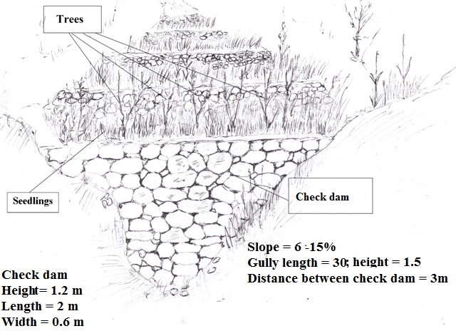
作者:
Aslam Qadamov; Roziya Kirgizbekova
日期:
03/04/2017
4.2 技术规范/技术图纸说明
A check dam is a permanent structure across a gully. The size of the check dam and the spacing of check dams depends on the steepness of the slope and length of the gully. To rehabilitate a gully on a slope of 6 - 15 % steepness and 30 meters in length there are 10 check dams built inside the gully at a distance of 3 meters apart. The measurements of the check dam are: 1.2 m x 2 m x 0.6 m. The dam is built from stones or boulders either available locally or transported to the gully site. The upper part of the gully is planted with rows of tree cuttings (7 pieces) and saplings (3 pieces).
4.3 有关投入和成本计算的一般信息
具体说明成本和投入是如何计算的:
- 每个技术单元
指定单位:
gully
指定体积、长度等(如果相关):
30 meter length, 1,5 meter depth, 6-15% slope
具体说明成本计算所用货币:
- 美元
注明美元与当地货币的汇率(如相关):1美元=:
67.0
注明雇用劳工的每日平均工资成本:
5.2-5.3 USD
4.4 技术建立活动
| 活动 | 措施类型 | 时间 | |
|---|---|---|---|
| 1. | Design of the check dam | 结构性的 | Winter |
| 2. | Digging the gully for preparation of construction work | 结构性的 | Spring |
| 3. | Construction of the stone wall accross the gully | 结构性的 | Spring |
| 4. | Filling the upper part of the stone wall with soil | 结构性的 | Spring |
| 5. | Planting of tree seedlings and cuttings on upper part of the wall | 植物性的 | Spring |
4.5 技术建立所需要的费用和投入
| 对投入进行具体说明 | 单位 | 数量 | 单位成本 | 每项投入的总成本 | 土地使用者承担的成本% | |
|---|---|---|---|---|---|---|
| 劳动力 | Design of the check dam | person-day | 2.0 | 5.3 | 10.6 | |
| 劳动力 | Digging the gully for preparation of construction work | person-day | 8.0 | 5.3 | 42.4 | |
| 劳动力 | Construction of stone wall | person-day | 12.0 | 5.3 | 63.6 | |
| 劳动力 | Planting of tree seedlings and cuttings | person-day | 2.0 | 5.3 | 10.6 | 100.0 |
| 设备 | Meter | piece | 1.0 | 2.2 | 2.2 | |
| 设备 | Shovel | piece | 2.0 | 3.8 | 7.6 | |
| 设备 | Axe | piece | 1.0 | 2.2 | 2.2 | |
| 设备 | Wheelbarrow | piece | 1.0 | 38.0 | 38.0 | |
| 设备 | Rope | meter | 100.0 | 0.07 | 7.0 | |
| 设备 | Pick axe | piece | 1.0 | 3.0 | 3.0 | |
| 设备 | Hammer | piece | 1.0 | 2.2 | 2.2 | |
| 植物材料 | Cuttings | piece | 100.0 | 0.37 | 37.0 | 50.0 |
| 植物材料 | Seedlings | piece | 10.0 | 0.6 | 6.0 | 50.0 |
| 施工材料 | Stone | cubic meter | 6.0 | 7.49 | 44.94 | |
| 技术建立所需总成本 | 277.34 | |||||
如果土地使用者负担的费用少于100%,请注明由谁负担其余费用:
Livelihood Improvement Project Takhar (LIPT) implemented by Terre des hommes (Tdh) Switzerland
4.6 维护/经常性活动
| 活动 | 措施类型 | 时间/频率 | |
|---|---|---|---|
| 1. | Protecting the trees from animals | 管理 | Continious |
| 2. | Watering the trees | 植物性的 | During dry season |
4.7 维护/经常性活动所需要的费用和投入(每年)
| 对投入进行具体说明 | 单位 | 数量 | 单位成本 | 每项投入的总成本 | 土地使用者承担的成本% | |
|---|---|---|---|---|---|---|
| 劳动力 | Protecting the trees from animals | person day | 45.0 | 1.3 | 58.5 | 100.0 |
| 劳动力 | Watering the trees | person day | 10.0 | 5.3 | 53.0 | 100.0 |
| 技术维护所需总成本 | 111.5 | |||||
4.8 影响成本的最重要因素
描述影响成本的最决定性因素:
Due to the remoteness of the villages where the technology has been implemented, all the inputs for establishment, such as agricultural equipment, plant material, fertilizers, construction material, etc., are purchased in Rustaq town. The expenses for traveling and delivering the inputs affect the establishment costs.
5. 自然和人文环境
5.1 气候
年降雨量
- < 250毫米
- 251-500毫米
- 501-750毫米
- 751-1,000毫米
- 1,001-1,500毫米
- 1,501-2,000毫米
- 2,001-3,000毫米
- 3,001-4,000毫米
- > 4,000毫米
指定年平均降雨量(若已知),单位为mm:
564.00
有关降雨的规范/注释:
Average annual precipitation for the area is 564 mm, with minimum in dry years (e.g. 2000 and 2001) of 270 mm and maximum in wet years (e.g. 2009 and 2010) of 830 mm. The data set shows an absolute maximum for annual rainfall for 1986, 1024 mm, and the absolute minimum for 2001, 269 mm. The data series covers the period from 1979 to 2014.
注明所考虑的参考气象站名称:
Climate Forecast System Reanalysis (CFSR), http://rda.ucar.edu/pub/cfsr.html
农业气候带
- 半干旱
Derived from the publicly available dataset on length of growing period (LGP) (Fischer 2009 / IIASA-FAO). Internet link: http://tiles.arcgis.com/tiles/P8Cok4qAP1sTVE59/arcgis/rest/services/Length_of_growing_period/MapServer
5.2 地形
平均坡度:
- 水平(0-2%)
- 缓降(3-5%)
- 平缓(6-10%)
- 滚坡(11-15%)
- 崎岖(16-30%)
- 陡峭(31-60%)
- 非常陡峭(>60%)
地形:
- 高原/平原
- 山脊
- 山坡
- 山地斜坡
- 麓坡
- 谷底
垂直分布带:
- 0-100 m a.s.l.
- 101-500 m a.s.l.
- 501-1,000 m a.s.l.
- 1,001-1,500 m a.s.l.
- 1,501-2,000 m a.s.l.
- 2,001-2,500 m a.s.l.
- 2,501-3,000 m a.s.l.
- 3,001-4,000 m a.s.l.
- > 4,000 m a.s.l.
5.3 土壤
平均土层深度:
- 非常浅(0-20厘米)
- 浅(21-50厘米)
- 中等深度(51-80厘米)
- 深(81-120厘米)
- 非常深(> 120厘米)
土壤质地(表土):
- 粗粒/轻(砂质)
- 中粒(壤土、粉土)
土壤质地(地表以下> 20厘米):
- 粗粒/轻(砂质)
- 中粒(壤土、粉土)
表土有机质:
- 低(<1%)
如有可能,附上完整的土壤描述或具体说明可用的信息,例如土壤类型、土壤酸碱度、阳离子交换能力、氮、盐度等。:
Local land users differentiate between the following soil types where gully rehabilitation is implemented:
- Red: shallow; texture medium, coarse; low organic matter
- Light: moderately deep; texture medium; medium, low organic matter
5.4 水资源可用性和质量
地下水位表:
5-50米
地表水的可用性:
中等
水质(未处理):
良好饮用水
水的盐度有问题吗?:
否
该区域正在发生洪水吗?:
是
规律性:
偶然
关于水质和水量的注释和进一步规范:
Floods occur mainly during the rainy seasons in spring and autumn. Availability of surface water differs for the study villages Sari Joy and Jawaz Khana. Sari Joy has sources and good surface water availability. Jawaz Khana has poor water availability as water has to be fetched from a lower stream.
5.5 生物多样性
物种多样性:
- 低
栖息地多样性:
- 低
5.6 应用该技术的土地使用者的特征
定栖或游牧:
- 定栖的
生产系统的市场定位:
- 生计(自给)
- 混合(生计/商业
非农收入:
- 收入的10-50%
- > 收入的50%
相对财富水平:
- 贫瘠
- 平均水平
个人或集体:
- 团体/社区
机械化水平:
- 手工作业
- 畜力牵引
性别:
- 女人
- 男人
土地使用者的年龄:
- 中年人
- 老年人
说明土地使用者的其他有关特征:
The land users in the area where the Technology is applied belong to the Uzbek ethnic minority group Qarluq.
Although the men are generally the main land users, however, women and children also take active part in the related work. The functions of men and women are clearly distinguished within the Afghan society. At the same time within the family this division of work and functions also results in men and women working hand-in-hand. An improvement of the family’s livelihood situation is expected to positively affect all family members. While, it is recognized that the involvement of women is key in order to secure basic human rights for everyone, to achieve good governance, sustainable development, and to efficiently contribute to poverty reduction (SDC 2004), it is also clear that a context sensitive approach is of high importance.
Women in rural Afghanistan are involved in many production and income generating activities that contribute to the overall household income, however, very few women own resources such as land and livestock, and their income generating options are fewer in comparison to that of men.
5.7 应用该技术的土地使用者拥有或租用的平均土地面积
- < 0.5 公顷
- 0.5-1 公顷
- 1-2 公顷
- 2-5公顷
- 5-15公顷
- 15-50公顷
- 50-100公顷
- 100-500公顷
- 500-1,000公顷
- 1,000-10,000公顷
- > 10,000公顷
这被认为是小规模、中规模还是大规模的(参照当地实际情况)?:
- 中等规模的
5.8 土地所有权、土地使用权和水使用权
土地所有权:
- 社区/村庄
土地使用权:
- 社区(有组织)
6. 影响和结论性说明
6.1 该技术的现场影响
社会经济效应
生产
作物生产
注释/具体说明:
Treatment of gullies on cropland, forest (mixed) land and grazing land protects the land from further erosion and protects the crop.
饲料生产
畜牧生产
产品多样性
生产区域
注释/具体说明:
Through implementation of gully treatment the area that was lost to gully formation can be used for production purposes again.
生态影响
水循环/径流
地表径流
土壤
土壤流失
生物多样性:植被、动物
植被覆盖
6.2 该技术的场外影响已经显现
下游洪水
下游淤积
缓冲/过滤能力
有关影响评估的意见:
Based on the Land User Protocols: Individual SLM implementers were asked to rate the benefits for their Technology. They were asked to indicate production increase of crops; fodder; animals; wood; non-wood forest products; increase in product diversity; or production area. The most important increase they rated with 3, the second most with 2, others with 1 point. Averages of the points given by all SLM implementers are reflected here.
Based on the Land User Protocols: Individual SLM implementers were asked to rate the on-site and off-site impacts of the Technology on water; soil; and vegetation. They were asked to indicate the strength of impacts with three, two or one points. Averages of the points given by all implementers are reflected here.
6.3 技术对渐变气候以及与气候相关的极端情况/灾害的暴露和敏感性(土地使用者认为的极端情况/灾害)
气候有关的极端情况(灾害)
气象灾害
| 该技术是如何应对的? | |
|---|---|
| 局地暴雨 | 非常好 |
气候灾害
| 该技术是如何应对的? | |
|---|---|
| 干旱 | 好 |
注释:
SLM implementers from three villages were asked to jointly discuss and rate how much the SLM technology reduced the lands vulnerability to drought and local rainstorms. Only vulnerability to the most prevalent climate extremes (drought and local rainstorms) was discussed. SLM technologies were rated as reducing vulnerability poorly , well, or very well. The average points reflected here are from multi-criteria matrices compiled in three villages where the SLM technology had been implemented.
6.4 成本效益分析
技术收益与技术建立成本相比如何(从土地使用者的角度看)?
短期回报:
非常积极
长期回报:
非常积极
注释:
SLM implementers from three villages were asked to jointly discuss and rate the SLM technologies short term (1-3 years) and long-term (10 years) return. As most of the technologies have only been implemented 1-2 years ago, it is too early to compare benefits to maintenance costs. Farmers have little experience so far on the actual benefits of the SLM technologies. The ratings are mostly based on expected benefits and not on actual benefits.
6.5 技术采用
- 1-10%
如若可行,进行量化(住户数量和/或覆盖面积):
2 households
在所有采用这项技术的人当中,有多少人是自发地采用该技术,即未获得任何物质奖励/付款?:
- 0-10%
注释:
2 land users replicated the technology without receiving financial support.
6.6 适应
最近是否对该技术进行了修改以适应不断变化的条件?:
否
6.7 该技术的优点/长处/机会
| 土地使用者眼中的长处/优势/机会 |
|---|
| Through the technology implementation expansion of the gully is halted and loss of land is prevented. |
| The land is less vulnerable to heavy rainfall. Agricultural land, houses and local infrastructure are protected from flood damage during the rainy season. |
| The grass which grows on the rehabilitated gullies can be used for livestock fodder. |
| 编制者或其他关键资源人员认为的长处/优势/机会 |
|---|
| Expansion of the production area to be used for cultivation or reforestation in a long-term perspective |
6.8 技术的弱点/缺点/风险及其克服方法
| 土地使用者认为的弱点/缺点/风险 | 如何克服它们? |
|---|---|
| Requires significant resources to cover all the costs for establishment | |
| Establishment of check dams is highly labour intensive |
| 编制者或其他关键资源人员认为的弱点/缺点/风险 | 如何克服它们? |
|---|---|
| Requires continuous maintenance to prevent damage to the constructed check dams. Protection of the trees from grazing and illegal logging is needed. | |
| Technical knowledge and support is required to design and construct the gullies in accordance with local conditions and available material |
7. 参考和链接
7.1 信息的方法/来源
- 实地考察、实地调查
No field visits were conducted.
- 与土地使用者的访谈
Focus group discussions (FGD) were organized by the CDE team to collect information from SLM implementers. 3 land users who have implemented the technology participated in the FGDs held in Sari Joy and Jawaz Khana.
Interviews were conducted by the HAFL team to collect information from persons representing the study villages. Very detailed interviews were conducted with 40 persons interested in terrace implementation, of which 17 persons are from households that already have implemented terraces.
- 与SLM专业人员/专家的访谈
Close collaboration took place during the compilation of this material with the technical staff of the LIPT project in Rustaq.
- 根据报告和其他现有文档进行编译
Information provided in the reports of the LIPT project in Rustaq served as an initial source of information during the preparatory phase and also solidifying the description of the technology and area of implementation. Other background papers on Afghanistan were referred to for general information on agriculture and natural resource management in Afghanistan.
7.2 参考可用出版物
标题、作者、年份、ISBN:
Guidelines for Focus Groups Discussions
标题、作者、年份、ISBN:
Methods section of the Rustaq NRM study
链接和模块
全部展开 全部收起链接
无链接
模块
无模块