Sunken streambed structure [Индия]
- Создание:
- Обновить:
- Составитель: David Gandhi
- Редактор: –
- Рецензенты: Fabian Ottiger, Alexandra Gavilano
DOH
technologies_1471 - Индия
Просмотреть разделы
Развернуть все Свернуть все1. Общая информация
1.2 Контактные данные специалистов и организаций, участвующих в описании и оценке Технологии
Специалист по УЗП:
Agrawal VK
Comprehensive Watershed Development Project
Индия
Специалист по УЗП:
Название проекта, содействовавшего документированию/оценке Технологии (если применимо)
Book project: Water Harvesting – Guidelines to Good Practice (Water Harvesting)Название проекта, содействовавшего документированию/оценке Технологии (если применимо)
Book project: where the land is greener - Case Studies and Analysis of Soil and Water Conservation Initiatives Worldwide (where the land is greener)1.3 Условия, регламентирующие использование данных, собранных ВОКАТ
Составитель и ответственный(-ые) специалист(-ы) согласны с условиями, регламентирующими использование собранных ВОКАТ данных:
Да
1.5 Ссылка на Анкету (ы) по Подходам УЗП (документируется с использованием ВОКАТ)
Comprehensive watershed development [Индия]
Participatory approach that includes a package of measures leading to empowerment of communities to implement and sustain watershed development.
- Составитель: David Gandhi
2. Описание Технологии УЗП
2.1 Краткое описание Технологии
Определение Технологии:
Excavations in streambeds to provide temporary storage of runoff, increasing water yields from shallow wells for supplementary irrigation.
2.2 Подробное описание Технологии
Описание:
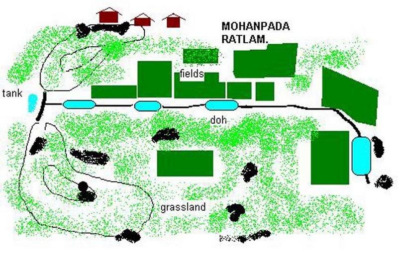
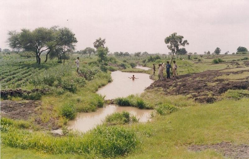
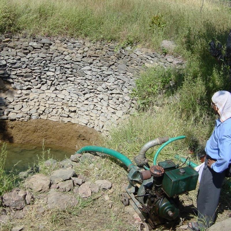
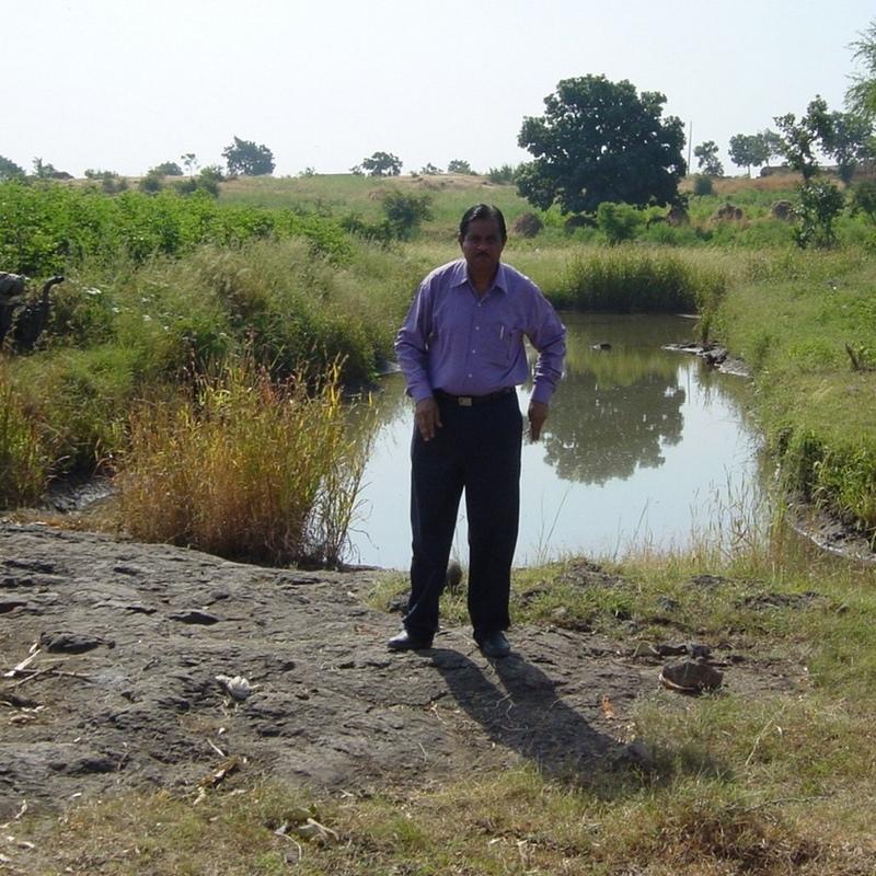
Dohs are rectangular excavations in seasonal streambeds, which are intended to capture and hold runoff to enhance groundwater recharge, thus increasing water for irrigation from nearby shallow wells. They also collect and impound subsurface flow. Dohs are built in semi-arid areas where rainfall is low and seasonal. The dimension of a typical doh is 1.0-1.5 m deep with variable length (up to 40 m) and width (up to 10 m) depending on streambed section, with an average capacity of 400 m3.
Purpose of the Technology: The excavated material is deposited along the stream banks as a barrier against siltation from surrounding areas. The slopes of the excavation are gentle (an upstream slope of 1:6 or 17% and a downstream slope of 1:8 or 12%) so that water flows into it, and excess water out again, carrying silt rather than depositing it. The sides however are steep, to increase capacity - and would benefit from stone pitching to stabilise them. A silt trap comprising a line of loose boulders is constructed upstream across the streambed. Dohs are generally built in sequence. They may be as close as a few metres apart. Bends in the stream are avoided as these are susceptible to bank erosion.
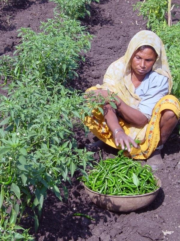
Establishment / maintenance activities and inputs: The technology is used in conjunction with shallow wells (odees), which enable farmers to harvest the increased groundwater for supplementary irrigation of annual crops- including vegetables such as chilli peppers. Water is pumped out of the wells. In the case study village, Mohanpada, each doh basically supplies an underground source of extra water to one well. Communities together with project staff carry out site selection, and then detailed design/estimates/layout is done with project technical assistance. As a supportive measure the catchment area is treated with gully plugs (small stone checks in gullies). A water harvesting tank (small reservoir or dam) may be excavated above the series of dohs where this is justified by a sufficiently large catchment area/suitable site. The capacity of the tank at Mohanpada is around 600 m3 and thus also has a positive impact on groundwater recharge.
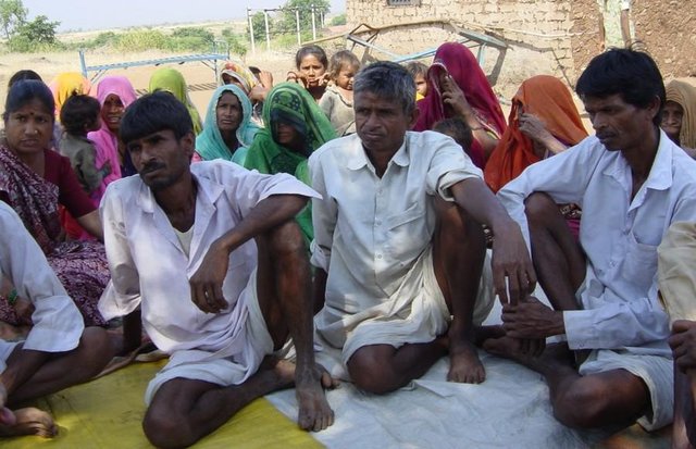
Natural / human environment: Maintenance is agreed through meetings of user groups: manual desilting is planned and repairs of gully plugs also. In summary, dohs are low cost water recharge alternatives for poorer communities, and in this case study, the extra area brought under production has meant that all families that require it, now have access to some water for irrigation.
2.3 Фотографии, иллюстрирующие Технологию
Медиа-галерея
2.5 Страна/ регион/ места, где применяется Технология, информация о которых собрана в данной Анкете
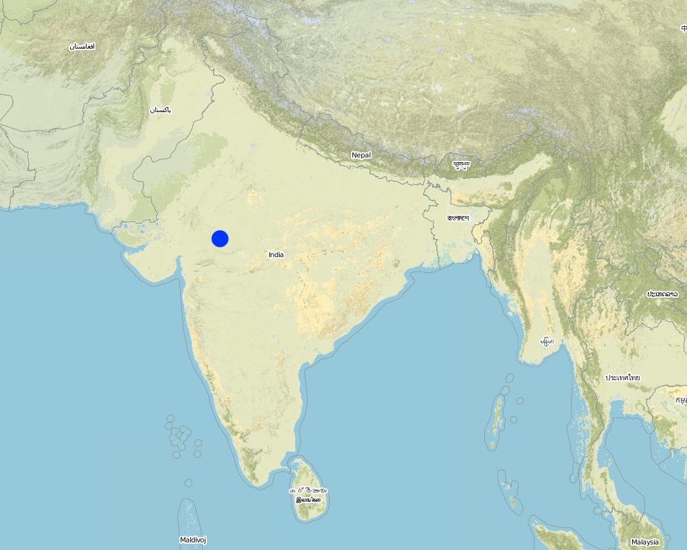
Страна:
Индия
Административная единица (Район/Область):
Madhya Pradesh
Более точная привязка места:
Ratlam, Mohanpada
Пояснения:
Total area covered by the SLM Technology is 0.1 km2.
The project area for phase 1 comprises 18 villages (3314 Households) mainly tribal. A significant portion of the area is barren and used for open grazing. The sunken wter harvesting technology was initially demonstrated in few villages as an alternative to the high cost heading type approach to water harvesting bieng implemented on a large scale by main line programmes.
Map
×2.6 Сколько лет применяется данная Технология
Если год начала применения Технологии достоверно неизвестен, дайте примерную оценку:
- более 50 лет назад (традиционная)
2.7 Внедрение Технологии
Укажите, как именно Технология УЗП была внедрена:
- через проекты/ внешнее вмешательство
Пояснения (тип проекта и т.д.):
The technology which is a modification of the traditional 'DOH' observed in river beds was implemented on an experimental basis in village Ambaohondan Tehsil 0 Mau, Dist. Indore under NWDPRA by Mr. V.K.Agrawal & Mr.V.V.Karmarkar.
3. Классификация Технологии УЗП
3.1 Основные цели и задачи реализации Технологии
- повышение производства
3.2 Текущий(-ие) тип(-ы) землепользования на территории, где применяется Технология
Комбинированное землепользование в пределах одной и той же земельной единицы:
Да
Укажите сочетания типов землепользования (посевы / пастбища / деревья):
- Агро-пастбищное хозяйство ( включая растениеводство-животноводство)

Пахотные угодья и плантации
- Однолетние культуры
Ежегодный урожай - Уточните культуры:
- волокнистые культуры - хлопок
- бобовые - зеленый горошек
- овощи - другие
- wheat, chili peppers
Число урожаев за год:
- 2
Поясните:
Longest growing period in days: 120 Longest growing period from month to month: Jul - Oct

Пастбищные угодья
- Extensive grazing
Пояснения:
Major land use problems (compiler’s opinion): There are regular poor yields of agricultural crops on the degraded, rainfed fields. A further constraint is the limited amount of water in wells, restricting both the extent of irrigation, and the number of people with access to irrigation. There is an underlying problem of poverty, which in turn leads to seasonal out-migration to find work.
Major land use problems (land users’ perception): Agricultural lands: sloping fields, soil loss, poor yields. Common lands:competition from surrounding villages for grazing resulting in low yields. Private pastures (bir): small patches which are not sufficient to meet the fodder needs. Settlement area: 28 huts already erected. Additional space not available.
Other grazingland: extensive grazing: on patches of waste lands within fields
Type of cropping system and major crops comments: During monsoon (kharif) season the main crop is cotton + maize. In addition minor pulses are taken. If water is available for irrigation, this is followed by wheat+gram in winter. Major area is fallow in winter except for the cotton crop which is of longer duration. No cultivation was observed in summer.
3.4 Водоснабжение
Обеспеченность водой участков, где реализуется Технология :
- богарные земли
Пояснения:
Water supply: Also mixed rainfed - irrigated
3.5 Категория УЗП, к которой относится Технология
- сбор атмосферных осадков
- Управление орошением (включая водоснабжение и дренаж)
- управление поверхностными водами (родники, реки, озёра, моря)
3.6 Мероприятия УЗП, выполняемые в рамках Технологии

инженерные мероприятия
Пояснения:
Main measures: structural measures
3.7 Основные проблемы деградации земель, на решение которых направлена Технология

водная эрозия почв
- ВЭл: овражная эрозия / оврагообразование

деградация водных ресурсов
- Ва: почвенная засуха
Пояснения:
Main type of degradation addressed: Wg: gully erosion / gullying, Ha: aridification
Main causes of degradation: other human induced causes (specify) (Social causes = Lack of awareness and mobilisation amongst the communities.), Top down approach (Macro planning rather than micro (village level) planning.)
3.8 Предотвращение и снижение деградации земель, или восстановление нарушенных земель
Укажите цель Технологии по отношению к деградации земель :
- снижение деградации земель
4. Технические характеристики, мероприятия по практической реализации, вложения и стоимость
4.1 Технический рисунок, иллюстрирующий Технологию
Спецификация (пояснения к техническому рисунку):
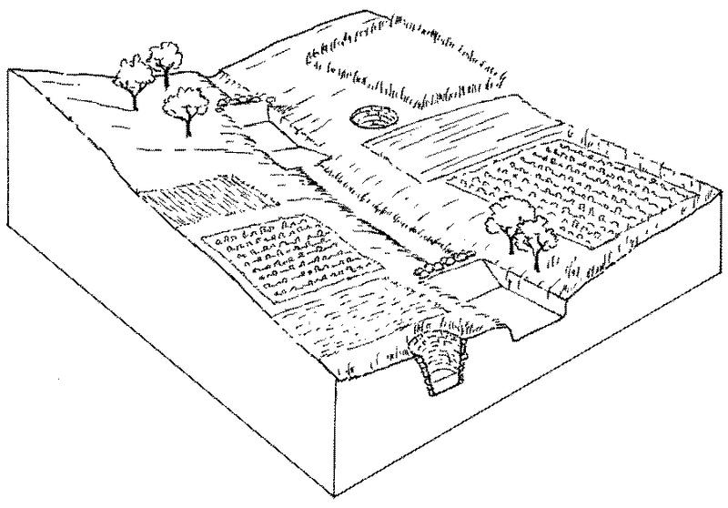
Overview of sunken streambed structures (doh) with associated wells and irrigated plots. Note that several dohs are applied in series along the waterway.
Technical knowledge required for field staff / advisors: moderate
Technical knowledge required for land users: low
Main technical functions: increase of infiltration, water harvesting / increase water supply
Secondary technical functions: control of concentrated runoff: retain / trap
Structural measure: doh (sunken streambed structure)
Structural measure: dam, gully plugs (supp.)
Construction material (stone): used for silt trap on the upstream side
Construction material (other): weathered section is excavated manually, while hard rock beds may be excavated by machine, dynamite.
Автор:
Mats Gurtner
4.2 Общая информация по необходимым вложениям и стоимости
другая/ национальная валюта (название):
Rupees
Если это необходимо, укажите обменный курс от доллара США к местной валюте (например, 1 доллар США = 79,9 бразильского реала): 1 доллар США =:
48,85
Укажите среднюю дневную заработную плату наемных работников:
1.00
4.3 Мероприятия, необходимые для начала реализации
| Деятельность | Время (сессия) | |
|---|---|---|
| 1. | Site selection with community by eye | Dry season |
| 2. | Identification of beneficiaries and user groups | Dry season |
| 3. | Design & estimation by project staff | Dry season |
| 4. | Agreement of village committee. | Dry season |
| 5. | Treatment of catchment with gully plug | Dry season |
| 6. | Excavation of Dohs (200–400 m3) as last action with silt traps upstreamof each made from loose stone. | Dry season |
| 7. | Wells (odees) may be deepened and pumps bought | Dry season |
4.4 Вложения и затраты, необходимые для начала реализации
| Опишите затраты | Единица | Количество | Затраты на единицу | Общая стоимость на единицу | % затрат, оплаченных землепользователями | |
|---|---|---|---|---|---|---|
| Оплата труда | Labour | ha | 1,0 | 225,0 | 225,0 | 25,0 |
| Оборудование | Tools | ha | 1,0 | 15,0 | 15,0 | 100,0 |
| Общая стоимость запуска Технологии | 240,0 | |||||
| Общие затраты на создание Технологии в долларах США | 4,91 | |||||
Пояснения:
Duration of establishment phase: 12 month(s)
4.5 Поддержание/ текущее обслуживание
| Деятельность | Сроки/ повторяемость проведения | |
|---|---|---|
| 1. | Maintenance of catchment treatments (desilting of gully plugs etc) | Dry Season/if required |
| 2. | Meeting of User Group | Monsoon/After heavy Showars |
| 3. | Repairs to Silt-trap | During monsoon/After heavy shower |
| 4. | Desilting of DOH | Dry Season/annual |
4.6 Стоимость поддержания/ текущего обслуживания ( в год)
| Опишите затраты | Единица | Количество | Затраты на единицу | Общая стоимость на единицу | % затрат, оплаченных землепользователями | |
|---|---|---|---|---|---|---|
| Оплата труда | Labour | ha | 1,0 | 5,0 | 5,0 | 100,0 |
| Общая стоимость поддержания Технологии | 5,0 | |||||
| Общие затраты на поддержание Технологии в долларах США | 0,1 | |||||
Пояснения:
The construction of one doh costs between US$ 200-400, depending on the size of the doh (approximately one cubic metre can be excavated per person day at a cost of one US dollar). On a per hectare basis the costs are very variable, since they are related to the extra area brought under irrigation. In this case study there are four dohs within a total village area of 50 ha. Ten of the 50 ha have been brought into irrigated production (extra to the 5 ha already irrigated) due to the four dohs and the ‘tank’ and the costs outlined above are spread over those 10 ha. In this case half of the costs are directly attributable to dohs (average capacity 400 m3 each), and half to catchment treatment where the water-harvesting tank (a reservoir of approximately 600 m3) is the main cost. Where there is underlying rock, mechanical drills and blasting by dynamite may be required, which increases the costs. That was not the case in this village. The cost of deepening/widening the five wells (odees) has not been included here: that is carried out by the villagers themselves. While the project normally pays around 85% of labour costs, here at Mohanpada village the project only needs to pay 75%, due to a high level of commitment by the villagers.
The total of 4 doh structure were constructed along a stream length of 451 m having gradient of 1.2%. Total storage capacity is 1646qm. It is observed that during past year (2002) the structures were completely filled & subsequently emptied (percolated) 5 times.
4.7 Наиболее значимые факторы, влияющие на стоимость затрат
Опишите наиболее значимые факторы, влияющие на стоимость затрат:
Presence of hard stata (bed rock) increases cost of excavation
5. Природные и социально-экономические условия
5.1 Климат
Среднегодовое количество осадков
- < 250 мм
- 251-500 мм
- 501-750 мм
- 751-1000 мм
- 1001-1500 мм
- 1501-2000 мм
- 2001-3000 мм
- 3001-4000 мм
- > 4000 мм
Укажите среднегодовое количество осадков (если известно), мм:
800,00
Пояснения/ комментарии по осадкам:
However since past 4 years rainfall has been below average
Агроклиматическая зона
- полузасушливая
Located on the tropic of cancer, characterised by hot dry summers (max 46 deg C) and cold dry winters. Monsoon (July-Sept) is characterised by high intensity showers followed by prolonged dry spells.
5.2 Рельеф
Склоны (преобладающие):
- пологие (0-2%)
- покатые (3-5%)
- покато-крутые (6-10%)
- крутые (11-15%)
- очень крутые (16-30%)
- чрезвычайно крутые (31-60%)
- обрывистые (>60%)
Формы рельефа:
- плато/ равнины
- гребни хребтов/холмов
- склоны гор
- склоны холмов
- подножья
- днища долин
Зона высотной поясности:
- 0-100 м над уровнем моря
- 101-500 м н.у.м.
- 501-1000 м н.у.м.
- 1001-1500 м н.у.м.
- 1501-2000 м н.у.м.
- 2001-2500 м н.у.м.
- 2501-3000 м н.у.м.
- 3001-4000 м н.у.м.
- > 4 тыс. м н.у.м.
Комментарии и дополнительные сведения по условиям рельефа/ топографии :
Slopes on average: Also gentle (ranked 2) and moderate (ranked 3)
5.3 Почвы
Средняя мощность почв:
- поверхностные (0-20 см)
- неглубокие (21-50 см)
- умеренно глубокие (51-80 см)
- глубокие (81-120 см)
- очень глубокие (> 120 см)
Гранулометрический состав (верхнего горизонта):
- грубый крупнозернистый/ лёгкий (песчаный)
- средние фракции (суглинистый, супесчаный)
Содержание органического вещества в верхнем горизонте:
- высокое (> 3%)
- среднее (1-3%)
Если возможно, приложите полное описание почв или укажите доступную информацию, например тип почв, рH/ кислотность почв, ёмкость катионного обмена, содержание азота, содержание солей и т.д.
Soil depth on average: Very shallow (ranked 1, eroded wastelands, fields on slopes) and shallow (ranked 2, fields in valley portion)
Soil texture: Medium (ranked 1, present in valley sections) and coarse/light (ranked 2, present along slopes)
Soil fertility: Low (ranked 1, fields along slopes,waste lands) and medium (ranked 2, fields in valley section)
Topsoil organic matter: High (ranked 1, fields along slopes, waste lands) and medium (ranked 2, fields in valley sections)
Soil drainage/infiltration: Medium
Soil water storage capacity: Low
5.6 Характеристика землепользователей, применяющих Технологию
Рыночная ориентация производства:
- смешанный (натуральный / коммерческий)
Доходы из других источников:
- 10-50% всех доходов
Относительный уровень достатка:
- очень плохой
- плохой
Уровень механизации:
- ручной труд
- тягловая сила
Укажите другие важные характеристики землепользователей:
Population density: > 500 persons/km2
Annual population growth: > 4%
1% of the land users are average wealthy (One family has bore-well).
19% of the land users are poor (Few farmers have access to shallow wells.).
80% of the land users are poor (Majority are small/marginal farmers without access to irrigation).
Off-farm income specification: some migratory work in nearby towns and in large scale mechanised farms during peak periods (note: now there is less migration as a result of increased irrigation)
5.7 Средняя площадь земель, используемых землепользователями с применением Технологии
- < 0,5 га
- 0,5-1 га
- 1-2 га
- 2-5 га
- 5-15 га
- 15-50 га
- 50-100 га
- 100-500 га
- 500-1000 га
- 1000-10000 га
- > 10000 га
5.8 Собственность на землю, права на земле- и водопользование
Землевладелец:
- общинная/ поселковая
- индивидуальная, оформленная в собственность
Право землепользования:
- неограниченное (неконтролируемое)
- индивидуальное
6. Воздействия и заключительные положения
6.1 Влияние Технологии УЗП в пределах территории ее применения
Социально-экономическое воздействие
Продуктивность
производство сельскозяйственных культур
Доходы и затраты
доходы хозяйства
экономическое неравенство
Комментарий/ пояснения:
Increased economic inequity in some villages, between those with wells and those without
Социальное и культурное воздействие
местное самоуправление
знания в области УЗП/ деградации земель
смягчение конфликтов
Комментарий/ пояснения:
Increased economic inequity in some villages, between those with wells and those without
Экологическое воздействие
Водный цикл/ поверхностный сток
уровень грунтовых/ подземных вод
Почвы
влажность почв
почвенный покров
Комментарий/ пояснения:
Where cultivated
утрата почв
Комментарий/ пояснения:
In catchment
6.2 Влияние Технологии за пределами территории ее применения
надежность и постоянство водотоков
подтопление ниже по течению
отложение наносов ниже по течению
загрязнение подземных/ речных вод
Amount of water to downstream users
6.4 Анализ эффективности затрат
Насколько получаемый результат сопоставим с первоначальными вложениями (с точки зрения землепользователей)?
Эффективность затрат в краткосрочной перспективе:
позитивное
Эффективность затрат в долгосрочной перспективе:
очень позитивное
Насколько получаемый результат сопоставим с текущими расходами по поддержанию технологии (с точки зрения землепользователей)?
Эффективность затрат в краткосрочной перспективе:
позитивное
Эффективность затрат в долгосрочной перспективе:
очень позитивное
6.5 Внедрение Технологии
Пояснения:
100% of land user families have adopted the Technology with external material support
1600 land user families have adopted the Technology with external material support
Comments on acceptance with external material support: estimates
There is a little trend towards spontaneous adoption of the Technology
Comments on adoption trend: Farmers in Mohanpada have constructed one doh with only 10 % subsidy on the total cost.
Spontaneous adoption is growing in neighbouring villages.
6.7 Сильные стороны/ преимущества/ возможности Технологии
| Сильные стороны/ преимущества/ возможности по мнению составителя или других ключевых специалистов |
|---|
|
Dohs are a low cost alternative method of increasing groundwater in a semi-arid area where production of high value legumes depends on irrigation – and dohs represent the best way in this situation of expanding the extent of irrigated land, and bringing irrigation to more families. |
|
Small, multiple recharge points for replenishing groundwater for irrigation from wells How can they be sustained / enhanced? Breaking hard pan in stream bed mechanically by drills or blasting to deepen dohs and thereby make them more effective. |
| No risk of breaches of bunds as the structures are sunken below ground. |
6.8 Слабые стороны/ недостатки/ риски Технологии и пути их преодоления
| Слабые стороны/ недостатки/ риски по мнению составителя или ответственных специалистов | Возможные пути их преодоления/снижения? |
|---|---|
| Group maintenance is required | Form user groups. |
| Villagers are more used to (and may prefer) larger and deeper ‘tanks’ | Establish more dohs to create more impact. |
| Dohs are limited in capacity and thus dry up quickly, as do the wells | Establish more dohs to create more impact. |
7. Справочные материалы и ссылки
7.1 Методы сбора/ источники информации
Ссылки и модули
Развернуть все Свернуть всеСсылки
Comprehensive watershed development [Индия]
Participatory approach that includes a package of measures leading to empowerment of communities to implement and sustain watershed development.
- Составитель: David Gandhi
Модули
Нет модулей