Farm pond [อินเดีย]
- ผู้สร้างสรรค์:
- การอัพเดท:
- ผู้รวบรวม: Channabasappa Metri
- ผู้เรียบเรียง: –
- ผู้ตรวจสอบ: Fabian Ottiger
krushi honda (Kannada)
technologies_1474 - อินเดีย
ดูส่วนย่อย
ขยายทั้งหมด ย่อทั้งหมด1. ข้อมูลทั่วไป
1.2 รายละเอียดที่ติดต่อได้ของผู้รวบรวมและองค์กรที่เกี่ยวข้องในการประเมินและการจัดเตรียมทำเอกสารของเทคโนโลยี
ผู้เชี่ยวชาญ SLM:
Benson Roland
08352 276586
Danida KWDP Bijapur
Bijapur
อินเดีย
ผู้เชี่ยวชาญ SLM:
Mujibur Rahman Syed
08352 276586
Danida KWDP Bijapur
Bijapur
อินเดีย
ผู้เชี่ยวชาญ SLM:
Thippeswamaiah
08352 276586
KWDP Daida Bijapur
Bijapur
อินเดีย
ชื่อขององค์กรซึ่งอำนวยความสะดวกในการทำเอกสารหรือการประเมินเทคโนโลยี (ถ้าเกี่ยวข้อง)
Danida assisted Karnataka Watershed Development Project, Bijapur (Danida assisted Karnataka Watershed Development Project, Bijapur) - อินเดีย1.3 เงื่อนไขการใช้ข้อมูลที่ได้บันทึกผ่านทาง WOCAT
วันที่เก็บรวบรวมข้อมูล(ภาคสนาม) :
16/02/2004
ผู้รวบรวมและวิทยากรหลักยอมรับเงื่อนไขเกี่ยวกับการใช้ข้อมูลที่ถูกบันทึกผ่านทาง WOCAT:
ใช่
1.5 อ้างอิงไปที่แบบสอบถามเรื่องแนวทาง SLM
Stakeholders participation in the project activities [อินเดีย]
SWC approach is a participatory methodology to empower the community to plan, implement, monitor, evaluate and manage the SWC technology to bring about sustainability
- ผู้รวบรวม: Pranesh Jahagirdar
2. การอธิบายลักษณะของเทคโนโลยี SLM
2.1 การอธิบายแบบสั้น ๆ ของเทคโนโลยี
คำจำกัดความของเทคโนโลยี:
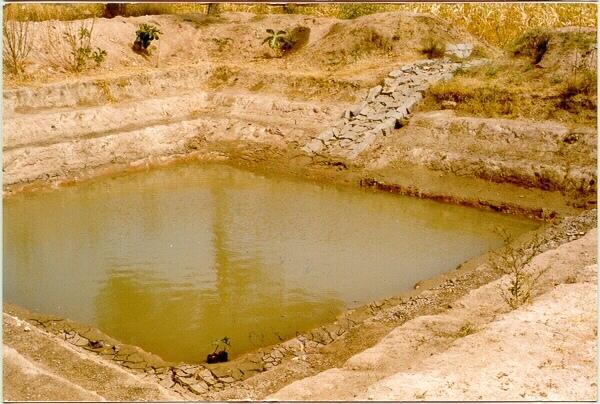
A sunken structure (12 x 12 x 3 m, more suiable), constructed by escavation in arable land with a view of temporary runoff storage tapped for protective irrigation, and to increase percolation for recharge of ground water (to convert surface to subsurface flow)
2.2 การอธิบายแบบละเอียดของเทคโนโลยี
คำอธิบาย:
A farm pond comprises of excavated portions of 12 x 12 x 3 m with the steps at 0.6m depth each. The excavated earth is deposited all around the structure as a bund, with a burm space of 1m. An inlet cum outlet provided in the course of flow of rain water to collect and dispose the excess runoff.
Purpose of the Technology: (1). For storage of exess runoff. (2) to increase percolation for ground water recharge, (3). To use for protective irrigation during dry period, (4). To stop further deepening of watercourse in arable lands
Establishment / maintenance activities and inputs: Selection of beneficiary is by the community and site selection, Design/ layout and excavation by the project staff with participation of the beneficiary. Desilting of the structure is by the beneficiary
Natural / human environment: surrounding lands are more slopy and with exposed rocks, most of the surrounding area is left for grazing
2.3 รูปภาพของเทคโนโลยี
อัลบั้มสื่อบันทึก
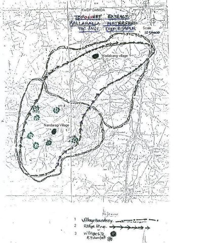
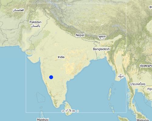
2.5 ประเทศภูมิภาค หรือสถานที่ตั้งที่เทคโนโลยีได้นำไปใช้และได้รับการครอบคลุมโดยการประเมินนี้
ประเทศ:
อินเดีย
ภูมิภาค/รัฐ/จังหวัด:
Karnataka
ข้อมูลจำเพาะเพิ่มเติมของสถานที่ตั้ง :
Bijapur district, Hadalsang village
Map
×2.6 วันที่การดำเนินการ
ถ้าไม่รู้ปีที่แน่นอน ให้ระบุวันที่โดยประมาณ:
- น้อยกว่า 10 ปี (ไม่นานนี้)
2.7 คำแนะนำของเทคโนโลยี
ให้ระบุว่าเทคโนโลยีถูกแนะนำเข้ามาอย่างไร:
- ทางโครงการหรือจากภายนอก
ความคิดเห็น (ประเภทของโครงการ เป็นต้น) :
Department of Agriculture, Govet. Of Karnataka
3. การจัดประเภทของเทคโนโลยี SLM
3.1 วัตถุประสงค์หลักของเทคโนโลยี
- ปรับปรุงการผลิตให้ดีขึ้น
- อนุรักษ์ระบบนิเวศน์
- ปรับตัวเข้ากับการเปลี่ยนแปลงภูมิอากาศของโลก สภาพภูมิอากาศที่รุนแรงและผลกระทบ
3.2 ประเภทของการใช้ที่ดินในปัจจุบันที่ได้นำเทคโนโลยีไปใช้

พื้นที่ปลูกพืช
- การปลูกพืชล้มลุกอายุปีเดียว
พืชหลัก (พืชเศรษฐกิจและพืชอาหาร):
Major cash crop: Chilli
Major food crop: Jowar
Major other crops: Brinjal, castor, lady's finger
แสดงความคิดเห็น:
Major land use problems (compiler’s opinion): The lands are very undulating (Class-V as per the Land Capability Classification), with very shallow soils, feasible for only one rainfed crops.
Major land use problems (land users’ perception): Poor yields due to shallow soils that too only one crop in one season, undulating lands leading to more runoff.
Type of cropping system and major crops comments: minor pulses - cereals (green gram-jowar)
Constraints of wastelands / deserts / glaciers / swamps: Highly eroded, unsuitable for any production purposes.
3.3 ข้อมูลเพิ่มเติมเกี่ยวกับการใช้ที่ดิน
การใช้น้ำของที่ดินที่มีการใช้เทคโนโลยีอยู่:
- จากน้ำฝน
แสดงความคิดเห็น:
Water supply: Also mixed rainfed - irrigated (ranked 2)
จำนวนของฤดูเพาะปลูกต่อปี:
- 2
ระบุ:
Longest growing period in days: 120 Longest growing period from month to month: Sep - Dec Second longest growing period in days: 90 Second longest growing period from month to month: Jul - Sep
3.4 กลุ่ม SLM ที่ตรงกับเทคโนโลยีนี้
- การเก็บเกี่ยวน้ำ
- การจัดการด้านชลประทาน (รวมถึงการลำเลียงส่งน้ำ การระบายน้ำ)
3.5 กระจายตัวของเทคโนโลยี
ระบุการกระจายตัวของเทคโนโลยี:
- กระจายไปอย่างสม่ำเสมอในพื้นที่
ถ้าหากว่าเทคโนโลยีได้มีการกระจายออกไปอย่างสม่ำเสมอในพื้นที่ ให้ระบุปริมาณพื้นที่ที่ได้รับการครอบคลุมถึง:
- < 0.1 ตร.กม.(10 เฮกตาร์)
แสดงความคิดเห็น:
Total area covered by the SLM Technology is 3 m2.
The technology area comprising of 2.8 ha within the overall watershed area of 2458 ha. The technology is useful in harvesting the excess rainwater in the arable land and re-use the for protective irigation after the rainy period.
3.6 มาตรการ SLM ที่ประกอบกันเป็นเทคโนโลยี
3.7 รูปแบบหลักของการเสื่อมโทรมของที่ดินที่ได้รับการแก้ไขโดยเทคโนโลยี

การกัดกร่อนของดินโดยน้ำ
- Wt (Loss of topsoil): การสูญเสียดินชั้นบนหรือการกัดกร่อนที่ผิวดิน
- Wg (Gully erosion): การกัดกร่อนแบบร่องธารหรือการทำให้เกิดร่องน้ำเซาะ
- Wo (Offsite degradation): ผลกระทบนอกพื้นที่
แสดงความคิดเห็น:
Main type of degradation addressed: Wt: loss of topsoil / surface erosion
Secondary types of degradation addressed: Wg: gully erosion / gullying, Wo: offsite degradation effects
Main causes of degradation: other natural causes (avalanches, volcanic eruptions, mud flows, highly susceptible natural resources, extreme topography, etc.) specify, poverty / wealth (lack of captial)
Secondary causes of degradation: other human induced causes (specify) (other (migration)), labour availability (lack of labour, cost of labour), education, access to knowledge and support services (lack of knowledge)
3.8 การป้องกัน การลดลง หรือการฟื้นฟูความเสื่อมโทรมของที่ดิน
ระบุเป้าหมายของเทคโนโลยีกับความเสื่อมโทรมของที่ดิน:
- ป้องกันความเสื่อมโทรมของที่ดิน
- ลดความเสื่อมโทรมของดิน
แสดงความคิดเห็น:
Main goals: mitigation / reduction of land degradation
Secondary goals: prevention of land degradation
4. ข้อมูลจำเพาะด้านเทคนิค กิจกรรมการนำไปปฏิบัติใช้ ปัจจัยนำเข้า และค่าใช้จ่าย
4.1 แบบแปลนทางเทคนิคของเทคโนโลยี

ผู้เขียน:
C.G Metri, JPO, KWDP Danida Bi
4.2 ข้อมูลจำเพาะด้านเทคนิคและการอธิบายแบบแปลนทางเทคนิค
The drawing showing the details of the farm pond. 12 x 12 x 3 m dimension. Five steps cutting on each side with 1:1 side slope. 1m birm (space) between the earthen bund. 1m wide spilway inlet cum outlet at suitable place of the site.
Location: Kallahalla nala watershed, Indi Taluk. Bijapur district of Karnataka state
Date: 20.4.2004
Technical knowledge required for field staff / advisors: moderate
Technical knowledge required for land users: high
Main technical functions: water harvesting / increase water supply
Secondary technical functions: increase of infiltration, increase / maintain water stored in soil
Structural measure: sediment sand / trap
Depth of ditches/pits/dams (m): 3
Width of ditches/pits/dams (m): 15
Length of ditches/pits/dams (m): 15
Height of bunds/banks/others (m): 1
Width of bunds/banks/others (m): 1
Length of bunds/banks/others (m): 15
Construction material (earth): soil excavated from the pond is used to for bunds all around the structure with 1 m birm space.
Construction material (stone): The spillway Inlet cum Outlet is constructed using stones
For water harvesting: the ratio between the area where the harvested water is applied and the total area from which water is collected is: 1:7
Vegetation is used for stabilisation of structures.
4.3 ข้อมูลทั่วไปเกี่ยวกับการคำนวณปัจจัยนำเข้าและค่าใช้จ่าย
อื่นๆ หรือสกุลเงินประจำชาติ (ระบุ):
Ruppes
ระบุอัตราแลกเปลี่ยนจากดอลลาร์สหรัฐเป็นสกุลเงินท้องถิ่น (ถ้าเกี่ยวข้อง) คือ 1 เหรียญสหรัฐ =:
46.0
ระบุค่าเฉลี่ยของค่าจ้างในการจ้างแรงงานต่อวัน:
0.73
4.4 กิจกรรมเพื่อการจัดตั้ง
| กิจกรรม | ประเภทของมาตรการ | ช่วงเวลาดำเนินการ | |
|---|---|---|---|
| 1. | selection of site and survey, preparation of estimates | ด้วยโครงสร้าง | summer |
| 2. | submission for sanction of approval | ด้วยโครงสร้าง | summer |
| 3. | Excavation of the farmpond | ด้วยโครงสร้าง | summer |
| 4. | construction of inlet/ outlet | ด้วยโครงสร้าง | before monsoon starts |
4.5 ค่าใช้จ่ายของปัจจัยนำเข้าที่จำเป็นสำหรับการจัดตั้ง
| ปัจจัยนำเข้า | หน่วย | ปริมาณ | ค่าใช้จ่ายต่อหน่วย | ค่าใช้จ่ายทั้งหมดต่อปัจจัยนำเข้า | %ของค่าใช้จ่ายที่ก่อให้เกิดขึ้นโดยผู้ใช้ที่ดิน | |
|---|---|---|---|---|---|---|
| แรงงาน | Labour | ha | 1.0 | 360.0 | 360.0 | 10.0 |
| วัสดุสำหรับก่อสร้าง | Stone | ha | 1.0 | 109.43 | 109.43 | 100.0 |
| ค่าใช้จ่ายทั้งหมดของการจัดตั้งเทคโนโลยี | 469.43 | |||||
แสดงความคิดเห็น:
Duration of establishment phase: 0 month(s)
4.6 การบำรุงรักษาสภาพหรือกิจกรรมที่เกิดขึ้นเป็นประจำ
| กิจกรรม | ประเภทของมาตรการ | ช่วงระยะเวลา/ความถี่ | |
|---|---|---|---|
| 1. | Meeting with the farmer | ด้วยโครงสร้าง | monsoon/annual |
| 2. | Desilting of farmpond | ด้วยโครงสร้าง | summer season/once in 2 years |
| 3. | Repair of Inlet/Outlet | ด้วยโครงสร้าง | summer season/Every year |
| 4. | Trimming of Bund | ด้วยโครงสร้าง | summer season/Every year |
4.7 ค่าใช้จ่ายของปัจจัยนำเข้าและกิจกรรมที่เกิดขึ้นเป็นประจำที่ต้องการการบำรุงรักษา (ต่อปี)
| ปัจจัยนำเข้า | หน่วย | ปริมาณ | ค่าใช้จ่ายต่อหน่วย | ค่าใช้จ่ายทั้งหมดต่อปัจจัยนำเข้า | %ของค่าใช้จ่ายที่ก่อให้เกิดขึ้นโดยผู้ใช้ที่ดิน | |
|---|---|---|---|---|---|---|
| แรงงาน | Labour | ha | 1.0 | 7.3 | 7.3 | 100.0 |
| ค่าใช้จ่ายทั้งหมดของการบำรุงรักษาสภาพเทคโนโลยี | 7.3 | |||||
แสดงความคิดเห็น:
12 m x 12 m x 3 m size with all side slope of 1:1 (five steps of 0.6 m deep), Inlet cum outlet spilway constructed with stones. This indicates only the actual cost of construction. (excavation / earth wotk and stone work for inlet/outlet)
4.8 ปัจจัยสำคัญที่สุดที่มีผลกระทบต่อค่าใช้จ่าย
ปัจจัยสำคัญที่สุดที่มีผลกระทบต่อค่าใช้จ่ายต่างๆ:
If the implementation site is having the hard strata, then the cost will be more.
5. สิ่งแวดล้อมทางธรรมชาติและของมนุษย์
5.1 ภูมิอากาศ
ฝนประจำปี
- < 250 ม.ม.
- 251-500 ม.ม.
- 501-750 ม.ม.
- 751-1,000 ม.ม.
- 1,001-1,500 ม.ม.
- 1,501-2,000 ม.ม.
- 2,001-3,000 ม.ม.
- 3,001-4,000 ม.ม.
- > 4,000 ม.ม.
ระบุปริมาณน้ำฝนเฉลี่ยรายปี (ถ้ารู้) :หน่วย ม.ม.
550.00
เขตภูมิอากาศเกษตร
- กึ่งแห้งแล้ง
Located on the latitude 16-49'N and longitude 75-43'E .Characterised by hot dry summer (42 °C) and cold dry winters monsoon (July-September) is characterised by high intensity showers followed by pro
5.2 สภาพภูมิประเทศ
ค่าเฉลี่ยความลาดชัน:
- ราบเรียบ (0-2%)
- ลาดที่ไม่ชัน (3-5%)
- ปานกลาง (6-10%)
- เป็นลูกคลื่น (11-15%)
- เป็นเนิน (16-30%)
- ชัน (31-60%)
- ชันมาก (>60%)
ธรณีสัณฐาน:
- ที่ราบสูง/ที่ราบ
- สันเขา
- ไหล่เขา
- ไหล่เนินเขา
- ตีนเนิน
- หุบเขา
ระดับความสูง:
- 0-100 เมตร
- 101-500 เมตร
- 501-1,000 เมตร
- 1,001-1,500 เมตร
- 1,501-2,000 เมตร
- 2,001-2,500 เมตร
- 2,501-3,000 เมตร
- 3,001-4,000 เมตร
- > 4,000 เมตร
ความคิดเห็นและข้อมูลจำเพาะเพิ่มเติมเรื่องสภาพภูมิประเทศ:
Altitudinal zone: 501-1000 m a.s.l. (594 m a.s.l.)
Slopes on average: Gentle (ridge and valley portion)
5.3 ดิน
ค่าเฉลี่ยความลึกของดิน:
- ตื้นมาก (0-20 ซ.ม.)
- ตื้น (21-50 ซ.ม.)
- ลึกปานกลาง (51-80 ซ.ม.)
- ลึก (81-120 ซ.ม.)
- ลึกมาก (>120 ซ.ม.)
เนื้อดิน (ดินชั้นบน):
- ปานกลาง (ดินร่วน ทรายแป้ง)
อินทรียวัตถุในดิน:
- ต่ำ (<1%)
(ถ้ามี) ให้แนบคำอธิบายเรื่องดินแบบเต็มหรือระบุข้อมูลที่มีอยู่ เช่น ชนิดของดิน ค่า pH ของดินหรือความเป็นกรดของดิน ความสามารถในการแลกเปลี่ยนประจุบวก ไนโตรเจน ความเค็ม เป็นต้น:
Soil depth on average: Shallow (30 cm)
Soil texture: Medium (medium in valley portion)
Soil fertility: Low (along the slope of the ridge, ranked 1) and medium (valley portion, ranked 2)
Topsoil organic matter: Low (in valley portion)
Soil water storage capacity: Low (hill portion, ranked 1) and medium (valley portion, ranked 2)
5.6 ลักษณะของผู้ใช้ที่ดินที่นำเทคโนโลยีไปปฏิบัติใช้
แนวทางการตลาดของระบบการผลิต:
- ผสม (การเลี้ยงชีพ/ทำการค้า)
รายได้ที่มาจากนอกฟาร์ม:
- 10-50% ของรายได้ทั้งหมด
ระดับของความมั่งคั่งโดยเปรียบเทียบ:
- จน
ระบุลักษณะอื่นๆที่เกี่ยวข้องของผู้ใช้ที่ดิน:
Population density: 100-200 persons/km2
Annual population growth: 3% - 4%
15% of the land users are very rich and own 5% of the land.
25% of the land users are rich and own 20% of the land.
50% of the land users are average wealthy and own 50% of the land.
10% of the land users are poor and own 15% of the land.
and own 10% of the land.
Off-farm income specification: Through sheep and goat rearing
Level of mechanization: Animal traction, (ranked 1, for ploughing, seed sowing harrowing), manual work (ranked 2, clod crushing, harvesting, threashing) and mechanised (ranked 3, Deep ploughing, levelling)
5.7 พื้นที่เฉลี่ยของที่ดินที่เป็นเจ้าของหรือเช่าโดยผู้ใช้ที่ดินที่นำเทคโนโลยีไปปฏิบัติใช้
- < 0.5 เฮกตาร์
- 0.5-1 เฮกตาร์
- 1-2 เฮกตาร์
- 2-5 เฮกตาร์
- 5-15 เฮกตาร์
- 15-50 เฮกตาร์
- 50-100 เฮกตาร์
- 100-500 เฮกตาร์
- 500-1,000 เฮกตาร์
- 1,000-10,000 เฮกตาร์
- >10,000 เฮกตาร์
แสดงความคิดเห็น:
Average area of land owned or leased by land users applying the Technology:
1-2 ha (ranked 1, marginal farmers [since the land holding decreases because of the fractionation the production and productivity also reduces])
2-5 ha (ranked 2, small farmers)
5-15 ha (ranked 3, big famers)
5.8 กรรมสิทธิ์ในที่ดิน สิทธิในการใช้ที่ดินและสิทธิในการใช้น้ำ
กรรมสิทธิ์ในที่ดิน:
- รายบุคคล ได้รับสิทธิครอบครอง
สิทธิในการใช้ที่ดิน:
- รายบุคคล
6. ผลกระทบและสรุปคำบอกกล่าว
6.1 ผลกระทบในพื้นที่ดำเนินการ (On-site) จากการใช้เทคโนโลยี
ผลกระทบทางด้านเศรษฐกิจและสังคม
การผลิต
การผลิตพืชผล
แสดงความคิดเห็น/ระบุ:
Second crop also taken
การผลิตพืชที่ใช้เลี้ยงปศุสัตว์
แสดงความคิดเห็น/ระบุ:
From trees
คุณภาพพืชที่ใช้เลี้ยงปศุสัตว์
แสดงความคิดเห็น/ระบุ:
From trees
ความหลากหลายของผลิตภัณฑ์
แสดงความคิดเห็น/ระบุ:
Difference in the crop like on bunds and in the patches of crops.
พื้นที่สำหรับการผลิต
แสดงความคิดเห็น/ระบุ:
15m x 15m land loss average land holding is very less, thus small & marginal farmers face reduction in the production area with this SWC
การจัดการที่ดิน
แสดงความคิดเห็น/ระบุ:
After implementing SWC less area is left for very small and marginal land holding.
ความเป็นประโยชน์และคุณภาพของน้ำ
การมีน้ำไว้ให้ปศุสัตว์
รายได้และค่าใช้จ่าย
รายได้จากฟาร์ม
แสดงความคิดเห็น/ระบุ:
Subsistance agriculture
ผลกระทบทางด้านเศรษฐกิจและสังคมอื่น ๆ
Input constraints
แสดงความคิดเห็น/ระบุ:
To bring new area into cultivation
ผลกระทบด้านสังคมวัฒนธรรมอื่น ๆ
SLM หรือความรู้เรื่องความเสื่อมโทรมของที่ดิน
ผลกระทบด้านนิเวศวิทยา
วัฐจักรน้ำหรือน้ำบ่า
การระบายน้ำส่วนเกิน
ดิน
ความชื้นในดิน
สิ่งปกคลุมดิน
การสูญเสียดิน
ผลกระทบด้านนิเวศวิทยาอื่น ๆ
Soil fertility
6.2 ผลกระทบนอกพื้นที่ดำเนินการ (Off-site) จากการใช้เทคโนโลยี
การไหลของน้ำคงที่และสม่ำเสมอในช่วงฤดูแล้ง
น้ำท่วมพื้นที่ท้ายน้ำ
แสดงความคิดเห็น/ระบุ:
Water storage in farm pond
6.4 การวิเคราะห์ค่าใช้จ่ายและผลประโยชน์ที่ได้รับ
ผลประโยชน์ที่ได้รับเปรียบเทียบกับค่าใช้จ่ายในการจัดตั้งเป็นอย่างไร (จากมุมมองของผู้ใช้ที่ดิน)
ผลตอบแทนระยะสั้น:
ด้านบวก
ผลตอบแทนระยะยาว:
ด้านบวก
ผลประโยชน์ที่ได้รับเปรียบเทียบกับค่าใช้จ่ายในการบำรุงรักษาหรือต้นทุนที่เกิดขึ้นซ้ำอีก เป็นอย่างไร (จากมุมมองของผู้ใช้ที่ดิน)
ผลตอบแทนระยะสั้น:
ด้านบวก
ผลตอบแทนระยะยาว:
ด้านบวก
6.5 การปรับตัวของเทคโนโลยี
แสดงความคิดเห็น:
There is a little trend towards spontaneous adoption of the Technology
Comments on adoption trend: The community is motivated with the benefits from this SWC structure. Some of them have already deepened the farmponds to increase its storage capacity.However, since most of the farmers are having very small land holdings and there was continous dry season from last three years, even if the farmers are motivated and aware of the technology of farmpond, they could not take up on their own (without financial assistance from the project.
6.7 จุดแข็ง / ข้อได้เปรียบ / โอกาสของเทคโนโลยี
| จุดแข็ง / ข้อได้เปรียบ / โอกาสในทัศนคติของผู้ใช้ที่ดิน |
|---|
|
Increased storage of water How can they be sustained / enhanced? Desilting by the farmer |
| Reduce gully formation |
|
Bring more area under irrigation How can they be sustained / enhanced? By giving life saving irrigation |
|
Economic benefits How can they be sustained / enhanced? By yields (monocropping to multiple cropping) --> more income |
|
Recycle the silt is beneficial How can they be sustained / enhanced? Other the silt would been lost every year and it is good to retain the soil fertility. |
| จุดแข็ง / ข้อได้เปรียบ / โอกาสในทัศนคติของผู้รวบรวมหรือวิทยากรหลัก |
|---|
|
Storage of water How can they be sustained / enhanced? By deepening |
|
Reduced runoff velocity How can they be sustained / enhanced? By mentainance |
|
Breaching of bunds down stream How can they be sustained / enhanced? By reducing the run-off |
|
Replicability How can they be sustained / enhanced? if a famer has his own labour/ man power then he can go for its construction. |
|
Water harvesting How can they be sustained / enhanced? recycle for protective irrigation during peak season. |
6.8 จุดอ่อน / ข้อเสียเปรียบ / ความเสี่ยงของเทคโนโลยีและวิธีการแก้ไข
| จุดอ่อน / ข้อเสียเปรียบ / ความเสี่ยงในทัศนคติของผู้ใช้ที่ดิน | มีวิธีการแก้ไขได้อย่างไร |
|---|---|
| Inability to contribute 100% towards cost of construction. | By giving schemes / financial assistance |
| Loosing of portion of cultivable land | By utilizing bunds, change in cropping system/ cropping pattern etc. |
| จุดอ่อน / ข้อเสียเปรียบ / ความเสี่ยงในทัศนคติของผู้รวบรวมหรือวิทยากรหลัก | มีวิธีการแก้ไขได้อย่างไร |
|---|---|
| Difficult to excavate in hard strata | can be done in shallow soils |
| Silt accumulation, if upper catchment is not treated | Treatment of upper catchment |
7. การอ้างอิงและการเชื่อมต่อ
7.2 การอ้างอิงถึงสิ่งตีพิมพ์
หัวข้อ, ผู้เขียน, ปี, หมายเลข ISBN:
Department Guidelines,Project Implementation plan, UAS Dharwad
ชื่อเรื่อง ผู้เขียน ปี ISBN:
In the office, personal contact
หัวข้อ, ผู้เขียน, ปี, หมายเลข ISBN:
PIP
ชื่อเรื่อง ผู้เขียน ปี ISBN:
in the office
หัวข้อ, ผู้เขียน, ปี, หมายเลข ISBN:
University of Agril. Sciences Dharwad
ชื่อเรื่อง ผู้เขียน ปี ISBN:
personal contact
ลิงก์และโมดูล
ขยายทั้งหมด ย่อทั้งหมดลิงก์
Stakeholders participation in the project activities [อินเดีย]
SWC approach is a participatory methodology to empower the community to plan, implement, monitor, evaluate and manage the SWC technology to bring about sustainability
- ผู้รวบรวม: Pranesh Jahagirdar
โมดูล
ไม่มีโมดูล