Cascading Rock Irrigation Channel [ทาจิกิสถาน]
- ผู้สร้างสรรค์:
- การอัพเดท:
- ผู้รวบรวม: Davlatbek Davlatov
- ผู้เรียบเรียง: –
- ผู้ตรวจสอบ: David Streiff, Alexandra Gavilano
Boloi Dasht (Tajik)
technologies_1454 - ทาจิกิสถาน
ดูส่วนย่อย
ขยายทั้งหมด ย่อทั้งหมด1. ข้อมูลทั่วไป
1.2 รายละเอียดที่ติดต่อได้ของผู้รวบรวมและองค์กรที่เกี่ยวข้องในการประเมินและการจัดเตรียมทำเอกสารของเทคโนโลยี
ผู้เชี่ยวชาญ SLM:
ชื่อขององค์กรซึ่งอำนวยความสะดวกในการทำเอกสารหรือการประเมินเทคโนโลยี (ถ้าเกี่ยวข้อง)
CAMP - Central Asian Mountain Partnership (CAMP - Central Asian Mountain Partnership) - คีร์กีซสถาน1.3 เงื่อนไขการใช้ข้อมูลที่ได้บันทึกผ่านทาง WOCAT
วันที่เก็บรวบรวมข้อมูล(ภาคสนาม) :
29/04/2011
ผู้รวบรวมและวิทยากรหลักยอมรับเงื่อนไขเกี่ยวกับการใช้ข้อมูลที่ถูกบันทึกผ่านทาง WOCAT:
ใช่
2. การอธิบายลักษณะของเทคโนโลยี SLM
2.1 การอธิบายแบบสั้น ๆ ของเทคโนโลยี
คำจำกัดความของเทคโนโลยี:
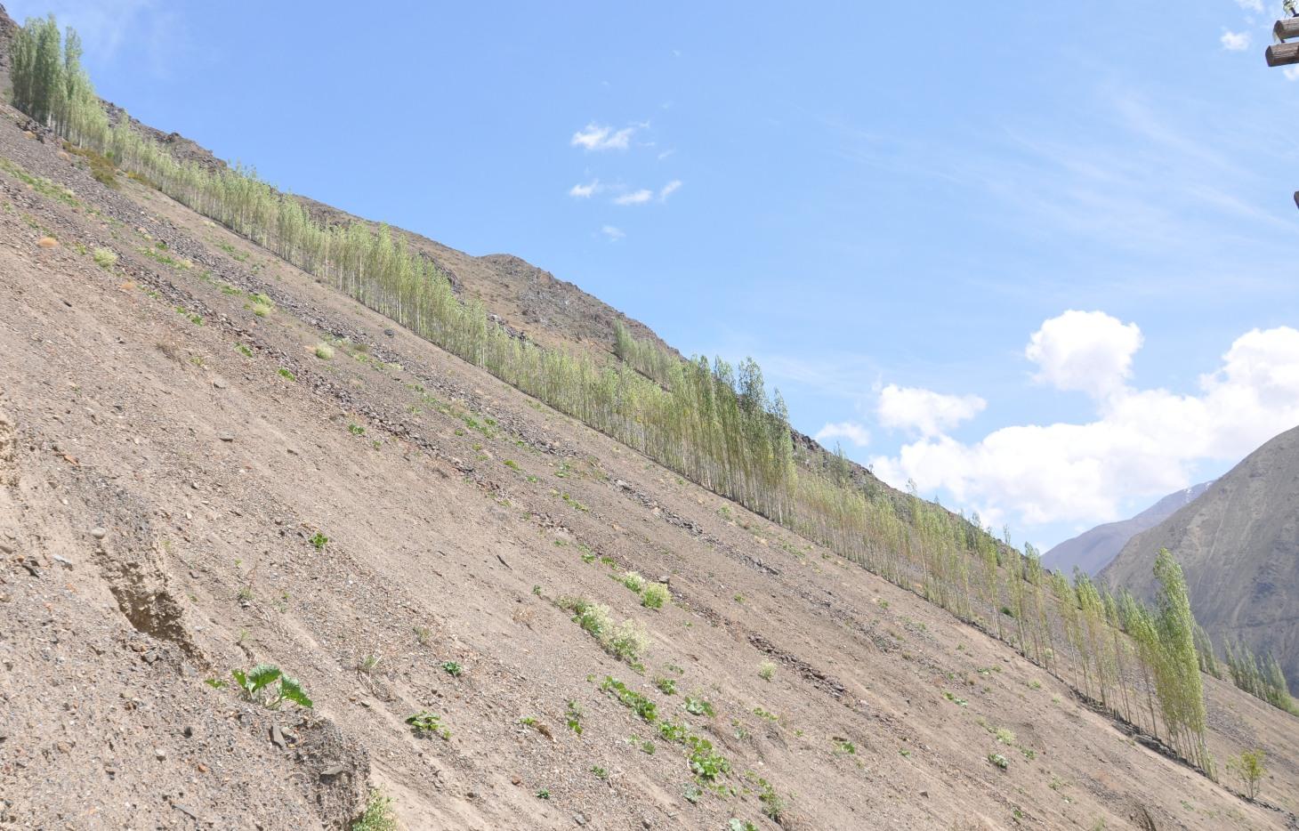
A cascading rock irrigation channel lined with fast growing poplar trees, constructed on rocky slopes to channel water runoff from the high mountains for human use at the valley floor.
2.2 การอธิบายแบบละเอียดของเทคโนโลยี
คำอธิบาย:
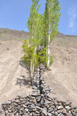
A one metre wide, 300m long, irrigation channel constructed of stones, that is built into the steep slope of a mountain gorge. The channel is 0.5m deep and is lined with poplar trees that help stabilise the structure. The water runs down the channel from the top mountains, with water splashing onto the poplar trees. At the foot of the channel the water is used to irrigated cultivated land and provide drinking water.
Purpose of the Technology: The main purpose of the cascading rock irrigation structure is to capture surface water run-off from the top of the mountain and channel it to where it can be utilised for human use such as drinking water, sanitation, and irrigation. The uneven surface of the rock channel slows the pace of the water thus preventing scouring at the foot of the channel. The channel also provides a suitable environment for the cultivation of poplar trees which in turn can help reduce water and wind erosion on the slopes, thus preventing rock and debris movement down onto the cultivated lands on the valley floor.
Establishment / maintenance activities and inputs: The channel is dug perpendicular to the steep slope and lined with stones gathered from the mountainous slopes. This activity is labour intensive, but can be more efficient with the use of donkeys. The stones are placed upon/on top of each other in the base of the channel, and used to line the sides of the channel to retain the water. The soil along the edge of the channel is cleared of debris and stone until it is suitable for the planting of poplar cuttings. The cutting are supplemented with organic fertiliser. The channel is financed by the land owner, with voluntary support from the community.
Natural / human environment: The cascading rock irrigation channel is located in a remote steep mountainous gorge where there is a shortage of land for cultivation. Water is in short supply, especially during the hot summer months. Subsequently the inhabitants have a high dependency on irrigated water from the top of the mountain range. The majority of the residents have a semi-subsistence living and are highly reliant upon the cultivated land where they grow a range of crops (e.g. wheat, potatoes. etc), fruits (e.g. apricots) and poplar trees for selling and construction purposes.
2.3 รูปภาพของเทคโนโลยี
อัลบั้มสื่อบันทึก
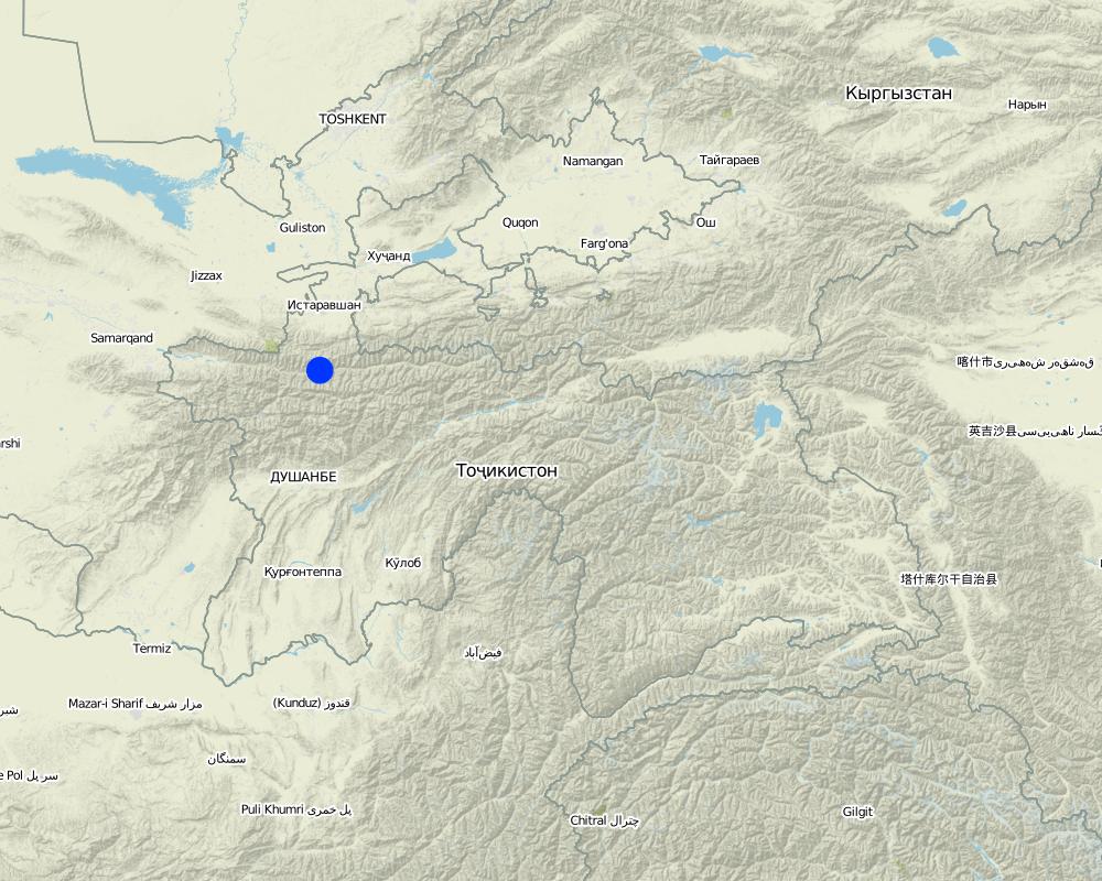
2.5 ประเทศภูมิภาค หรือสถานที่ตั้งที่เทคโนโลยีได้นำไปใช้และได้รับการครอบคลุมโดยการประเมินนี้
ประเทศ:
ทาจิกิสถาน
ภูมิภาค/รัฐ/จังหวัด:
Sogd region
ข้อมูลจำเพาะเพิ่มเติมของสถานที่ตั้ง :
Ayni
Map
×2.6 วันที่การดำเนินการ
ถ้าไม่รู้ปีที่แน่นอน ให้ระบุวันที่โดยประมาณ:
- 10-50 ปี
2.7 คำแนะนำของเทคโนโลยี
ให้ระบุว่าเทคโนโลยีถูกแนะนำเข้ามาอย่างไร:
- ด้วยการริเริ่มของผู้ใช้ที่ดินเอง
ความคิดเห็น (ประเภทของโครงการ เป็นต้น) :
The technology was constructed in 1992 and 1997 based upon ideas generated from the local inhabitants.
3. การจัดประเภทของเทคโนโลยี SLM
3.1 วัตถุประสงค์หลักของเทคโนโลยี
- ลด ป้องกัน ฟื้นฟู การเสื่อมโทรมของที่ดิน
- improved access to water
3.2 ประเภทของการใช้ที่ดินในปัจจุบันที่ได้นำเทคโนโลยีไปใช้

ป่า/พื้นที่ทำไม้
ป่ากึ่งธรรมชาติ / พื้นที่ทำไม้:
- การตัดไม้ที่มีคัดเลือก (Selective felling)
ป่า/พื้นที่ทำไม้:
- การปลูกพืชพันธุ์ท้องถิ่นชนิดเดียว
ผลิตภัณฑ์และบริการ:
- การป้องกันภัยธรรมชาติ
- construction

อื่น ๆ
ระบุ:
Wasteland: The mountain slopes are mainly devoid of vegetation.
แสดงความคิดเห็น:
Major land use problems (compiler’s opinion): Water and wind erosion, rockfalls and debris movement.
Major land use problems (land users’ perception): Debris movement due to excessive rains damaging crops and infrastructure.
Selective felling of (semi-) natural forests: Infrequent felling of poplars.
Forest products and services: timber, protection against natural hazards
Other forest products and services: construction
Future (final) land use (after implementation of SLM Technology): Forests / woodlands: Fp: Plantations, afforestations
Constraints of wastelands / deserts / glaciers / swamps
3.3 ข้อมูลเพิ่มเติมเกี่ยวกับการใช้ที่ดิน
การใช้น้ำของที่ดินที่มีการใช้เทคโนโลยีอยู่:
- จากน้ำฝน
จำนวนของฤดูเพาะปลูกต่อปี:
- 1
ระบุ:
Longest growing period in days: 180Longest growing period from month to month: March-October
3.4 กลุ่ม SLM ที่ตรงกับเทคโนโลยีนี้
- มาตรการปลูกพืชขวางความลาดชัน (cross-slope measure)
- การจัดการด้านชลประทาน (รวมถึงการลำเลียงส่งน้ำ การระบายน้ำ)
- การผันน้ำและการระบายน้ำ
3.5 กระจายตัวของเทคโนโลยี
ระบุการกระจายตัวของเทคโนโลยี:
- กระจายไปอย่างสม่ำเสมอในพื้นที่
ถ้าหากว่าเทคโนโลยีได้มีการกระจายออกไปอย่างสม่ำเสมอในพื้นที่ ให้ระบุปริมาณพื้นที่ที่ได้รับการครอบคลุมถึง:
- < 0.1 ตร.กม.(10 เฮกตาร์)
แสดงความคิดเห็น:
Long and narrow geographical areas were chosen for implementation of the technology. The technology was replicated ten times in this community area.
3.6 มาตรการ SLM ที่ประกอบกันเป็นเทคโนโลยี

มาตรการจัดการพืช
- A1: พืช/สิ่งปกคลุมดิน

มาตรการอนุรักษ์ด้วยวิธีพืช
- V1: ต้นไม้และพุ่มไม้คลุมดิน

มาตรการอนุรักษ์ด้วยโครงสร้าง
- S3: Graded ditches, channels, waterways
แสดงความคิดเห็น:
Main measures: vegetative measures, structural measures
Type of vegetative measures: aligned: -linear
3.7 รูปแบบหลักของการเสื่อมโทรมของที่ดินที่ได้รับการแก้ไขโดยเทคโนโลยี

การกัดกร่อนของดินโดยน้ำ
- Wg (Gully erosion): การกัดกร่อนแบบร่องธารหรือการทำให้เกิดร่องน้ำเซาะ
- Wm (Mass movement): การเคลื่อนตัวของมวลดินหรือดินถล่ม

การกัดกร่อนของดินโดยลม
- Ed (Deflation and deposition): การกัดกร่อนโดยลมและการทับถม
แสดงความคิดเห็น:
Main type of degradation addressed: Wm: mass movements / landslides
Secondary types of degradation addressed: Wg: gully erosion / gullying, Ed: deflation and deposition
Main causes of degradation: deforestation / removal of natural vegetation (incl. forest fires) (Removal of forest vegetation many years before.), Heavy / extreme rainfall (intensity/amounts) (Extreme events lead to debris movement covering fertile lands.)
Secondary causes of degradation: war and conflicts (Lack of natural resources during civil war led to the cutting of many of the trees preventing slope movement.)
3.8 การป้องกัน การลดลง หรือการฟื้นฟูความเสื่อมโทรมของที่ดิน
ระบุเป้าหมายของเทคโนโลยีกับความเสื่อมโทรมของที่ดิน:
- ลดความเสื่อมโทรมของดิน
4. ข้อมูลจำเพาะด้านเทคนิค กิจกรรมการนำไปปฏิบัติใช้ ปัจจัยนำเข้า และค่าใช้จ่าย
4.1 แบบแปลนทางเทคนิคของเทคโนโลยี
ผู้เขียน:
Davlatov Davlatbek, Dushanbe City,Rudaki str.131,fl.19
4.2 ข้อมูลจำเพาะด้านเทคนิคและการอธิบายแบบแปลนทางเทคนิค
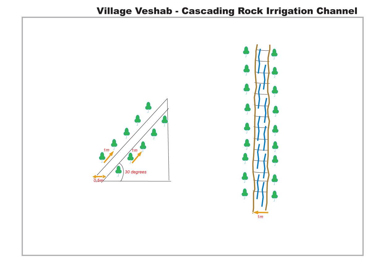
The drawing shows in plan and profile the cascading rock channel. The slope of the mountain is 30 degrees, a one metre wide channel, 0.5 m deep, is dug into the slope. The channel is lined with stones. The soil either side of the channel is cleared of rocks, and poplar branches are planted at 1m intervals lining the channel.
Location: Veshab Boloi Dasht. Ayni Sughd Region Tajikistan
Date: 2011-05-04
Technical knowledge required for land users: moderate (An understanding of how to build the basic structure without it collapsing and able to meet the discharge capacity of the water.)
Main technical functions: control of concentrated runoff: drain / divert, water harvesting / increase water supply, Prevent off site damage to cultivated land at the foot of the slope.
Secondary technical functions: Stabilisation of soil along the channel.
Aligned: -linear
Vegetative material: T : trees / shrubs
Number of plants per (ha): 600
Vertical interval within rows / strips / blocks (m): 1
Width within rows / strips / blocks (m): 1
Trees/ shrubs species: Poplars (safedor) are planted in vertical rows, 1m apart, on both sides of the 1m wide channel.
Slope (which determines the spacing indicated above): 30.00%
Waterway
Depth of ditches/pits/dams (m): 0.5
Width of ditches/pits/dams (m): 1
Length of ditches/pits/dams (m): 300
Construction material (stone): local stones and rocks
Slope (which determines the spacing indicated above): 30%
Vegetation is used for stabilisation of structures.
4.3 ข้อมูลทั่วไปเกี่ยวกับการคำนวณปัจจัยนำเข้าและค่าใช้จ่าย
ให้ระบุว่าค่าใช้จ่ายและปัจจัยนำเข้าได้รับการคำนวณอย่างไร:
- ต่อหน่วยเทคโนโลยี
อื่นๆ หรือสกุลเงินประจำชาติ (ระบุ):
Somoni
ระบุอัตราแลกเปลี่ยนจากดอลลาร์สหรัฐเป็นสกุลเงินท้องถิ่น (ถ้าเกี่ยวข้อง) คือ 1 เหรียญสหรัฐ =:
4.5
ระบุค่าเฉลี่ยของค่าจ้างในการจ้างแรงงานต่อวัน:
5.50
4.4 กิจกรรมเพื่อการจัดตั้ง
| กิจกรรม | ประเภทของมาตรการ | ช่วงเวลาดำเนินการ | |
|---|---|---|---|
| 1. | Planting Poplars | ด้วยวิธีพืช | Spring, March |
| 2. | Composting | ด้วยวิธีพืช | spring |
| 3. | Construction of rock irrigation channel | ด้วยโครงสร้าง | spring |
4.5 ค่าใช้จ่ายของปัจจัยนำเข้าที่จำเป็นสำหรับการจัดตั้ง
| ปัจจัยนำเข้า | หน่วย | ปริมาณ | ค่าใช้จ่ายต่อหน่วย | ค่าใช้จ่ายทั้งหมดต่อปัจจัยนำเข้า | %ของค่าใช้จ่ายที่ก่อให้เกิดขึ้นโดยผู้ใช้ที่ดิน | |
|---|---|---|---|---|---|---|
| แรงงาน | Planting Poplars | Persons/day | 10.0 | 25.0 | 250.0 | 100.0 |
| แรงงาน | Construction of rock irrigation channel | Persons/day | 60.0 | 25.0 | 1500.0 | 100.0 |
| อุปกรณ์ | Tools | Pieces | 3.0 | 20.0 | 60.0 | 100.0 |
| อุปกรณ์ | Donkey | Donkey/day | 20.0 | 22.5 | 450.0 | 100.0 |
| วัสดุด้านพืช | Seedlings | Unit | 1.0 | 266.0 | 266.0 | 100.0 |
| ปุ๋ยและสารฆ่า/ยับยั้งการเจริญเติบโตของสิ่งมีชีวิต (ไบโอไซด์) | Composte | per tree | 250.0 | 1.0 | 250.0 | 100.0 |
| วัสดุสำหรับก่อสร้าง | Stone | tons | 50.0 | 20.0 | 1000.0 | 100.0 |
| ค่าใช้จ่ายทั้งหมดของการจัดตั้งเทคโนโลยี | 3776.0 | |||||
แสดงความคิดเห็น:
Duration of establishment phase: 1 month(s)
4.6 การบำรุงรักษาสภาพหรือกิจกรรมที่เกิดขึ้นเป็นประจำ
| กิจกรรม | ประเภทของมาตรการ | ช่วงระยะเวลา/ความถี่ | |
|---|---|---|---|
| 1. | tree tending | ด้วยวิธีพืช | every year |
| 2. | Maintenance of channel | ด้วยโครงสร้าง | Spring |
4.7 ค่าใช้จ่ายของปัจจัยนำเข้าและกิจกรรมที่เกิดขึ้นเป็นประจำที่ต้องการการบำรุงรักษา (ต่อปี)
| ปัจจัยนำเข้า | หน่วย | ปริมาณ | ค่าใช้จ่ายต่อหน่วย | ค่าใช้จ่ายทั้งหมดต่อปัจจัยนำเข้า | %ของค่าใช้จ่ายที่ก่อให้เกิดขึ้นโดยผู้ใช้ที่ดิน | |
|---|---|---|---|---|---|---|
| แรงงาน | Tree tending | Persons/day | 7.0 | 25.0 | 175.0 | 100.0 |
| แรงงาน | Maintenance of channel | Persons/day | 10.0 | 25.0 | 250.0 | 100.0 |
| ค่าใช้จ่ายทั้งหมดของการบำรุงรักษาสภาพเทคโนโลยี | 425.0 | |||||
แสดงความคิดเห็น:
The indicative cost of the technology was calculated based on 2010 prices.
4.8 ปัจจัยสำคัญที่สุดที่มีผลกระทบต่อค่าใช้จ่าย
ปัจจัยสำคัญที่สุดที่มีผลกระทบต่อค่าใช้จ่ายต่างๆ:
There was no real cost in construction of the rock irrigation channel. All labour, animal traction and materials were sourced locally for no cost, poplar seedlings are cuttings from local poplars, and organic compost for the trees was collected from local livestock.
5. สิ่งแวดล้อมทางธรรมชาติและของมนุษย์
5.1 ภูมิอากาศ
ฝนประจำปี
- < 250 ม.ม.
- 251-500 ม.ม.
- 501-750 ม.ม.
- 751-1,000 ม.ม.
- 1,001-1,500 ม.ม.
- 1,501-2,000 ม.ม.
- 2,001-3,000 ม.ม.
- 3,001-4,000 ม.ม.
- > 4,000 ม.ม.
ข้อมูลจำเพาะ/ความคิดเห็นเรื่องปริมาณน้ำฝน:
Heavy Spring and Autumn Rain
เขตภูมิอากาศเกษตร
- กึ่งแห้งแล้ง
Thermal climate class: temperate. 4 months of snowing during the winter period.
5.2 สภาพภูมิประเทศ
ค่าเฉลี่ยความลาดชัน:
- ราบเรียบ (0-2%)
- ลาดที่ไม่ชัน (3-5%)
- ปานกลาง (6-10%)
- เป็นลูกคลื่น (11-15%)
- เป็นเนิน (16-30%)
- ชัน (31-60%)
- ชันมาก (>60%)
ธรณีสัณฐาน:
- ที่ราบสูง/ที่ราบ
- สันเขา
- ไหล่เขา
- ไหล่เนินเขา
- ตีนเนิน
- หุบเขา
ระดับความสูง:
- 0-100 เมตร
- 101-500 เมตร
- 501-1,000 เมตร
- 1,001-1,500 เมตร
- 1,501-2,000 เมตร
- 2,001-2,500 เมตร
- 2,501-3,000 เมตร
- 3,001-4,000 เมตร
- > 4,000 เมตร
ความคิดเห็นและข้อมูลจำเพาะเพิ่มเติมเรื่องสภาพภูมิประเทศ:
Altitudinal zone: This area is located at 1500m
5.3 ดิน
ค่าเฉลี่ยความลึกของดิน:
- ตื้นมาก (0-20 ซ.ม.)
- ตื้น (21-50 ซ.ม.)
- ลึกปานกลาง (51-80 ซ.ม.)
- ลึก (81-120 ซ.ม.)
- ลึกมาก (>120 ซ.ม.)
เนื้อดิน (ดินชั้นบน):
- หยาบ/เบา (ดินทราย)
อินทรียวัตถุในดิน:
- ต่ำ (<1%)
(ถ้ามี) ให้แนบคำอธิบายเรื่องดินแบบเต็มหรือระบุข้อมูลที่มีอยู่ เช่น ชนิดของดิน ค่า pH ของดินหรือความเป็นกรดของดิน ความสามารถในการแลกเปลี่ยนประจุบวก ไนโตรเจน ความเค็ม เป็นต้น:
Soil texture is rocky, shale.
Soil fertility is very low and nothing is growing on the adjacent slopes.
Soil drainage / infiltration is poor
Soil water storage capacity is very low.
5.4 ความเป็นประโยชน์และคุณภาพของน้ำ
ระดับน้ำใต้ดิน:
> 50 เมตร
น้ำไหลบ่าที่ผิวดิน:
ไม่ดีหรือไม่มีเลย
คุณภาพน้ำ (ที่ยังไม่ได้บำบัด):
เป็นน้ำเพื่อการดื่มที่ดี
5.5 ความหลากหลายทางชีวภาพ
ความหลากหลายทางชนิดพันธุ์:
- ต่ำ
ความคิดเห็นและข้อมูลจำเพาะเพิ่มเติมของความหลากหลายทางชีวภาพ:
No natural propogation/reproduction on the slope and slow growth rate without irrigation.
5.6 ลักษณะของผู้ใช้ที่ดินที่นำเทคโนโลยีไปปฏิบัติใช้
แนวทางการตลาดของระบบการผลิต:
- เพื่อการยังชีพ (หาเลี้ยงตนเอง)
- ผสม (การเลี้ยงชีพ/ทำการค้า)
รายได้ที่มาจากนอกฟาร์ม:
- > 50% ของรายได้ทั้งหมด
ระดับของความมั่งคั่งโดยเปรียบเทียบ:
- พอมีพอกิน
เป็นรายบุคคล/ครัวเรือน:
- กลุ่ม/ชุมชน
เพศ:
- หญิง
- ชาย
ระบุลักษณะอื่นๆที่เกี่ยวข้องของผู้ใช้ที่ดิน:
Land users applying the Technology are mainly common / average land users
Population density: < 10 persons/km2
Annual population growth: 1% - 2%
100% of the land users are average wealthy and own 100% of the land.
Off-farm income specification: Some of the incomes come from driving, teaching etc
Market orientation of production system: Poplars are used for personal construction projects but can be sold for $300 per tree.
5.7 พื้นที่เฉลี่ยของที่ดินที่เป็นเจ้าของหรือเช่าโดยผู้ใช้ที่ดินที่นำเทคโนโลยีไปปฏิบัติใช้
- < 0.5 เฮกตาร์
- 0.5-1 เฮกตาร์
- 1-2 เฮกตาร์
- 2-5 เฮกตาร์
- 5-15 เฮกตาร์
- 15-50 เฮกตาร์
- 50-100 เฮกตาร์
- 100-500 เฮกตาร์
- 500-1,000 เฮกตาร์
- 1,000-10,000 เฮกตาร์
- >10,000 เฮกตาร์
พิจารณาว่าเป็นขนาดเล็ก กลาง หรือขนาดใหญ่ (ซึ่งอ้างอิงถึงบริบทระดับท้องถิ่น):
- ขนาดเล็ก
5.8 กรรมสิทธิ์ในที่ดิน สิทธิในการใช้ที่ดินและสิทธิในการใช้น้ำ
กรรมสิทธิ์ในที่ดิน:
- รัฐ
สิทธิในการใช้ที่ดิน:
- เกี่ยวกับชุมชน (ถูกจัดระเบียบ)
สิทธิในการใช้น้ำ:
- เกี่ยวกับชุมชน (ถูกจัดระเบียบ)
5.9 การเข้าถึงบริการและโครงสร้างพื้นฐาน
สุขภาพ:
- จน
- ปานกลาง
- ดี
การศึกษา:
- จน
- ปานกลาง
- ดี
ความช่วยเหลือทางด้านเทคนิค:
- จน
- ปานกลาง
- ดี
การจ้างงาน (เช่น ภายนอกฟาร์ม):
- จน
- ปานกลาง
- ดี
ตลาด:
- จน
- ปานกลาง
- ดี
พลังงาน:
- จน
- ปานกลาง
- ดี
ถนนและการขนส่ง:
- จน
- ปานกลาง
- ดี
น้ำดื่มและการสุขาภิบาล:
- จน
- ปานกลาง
- ดี
บริการด้านการเงิน:
- จน
- ปานกลาง
- ดี
6. ผลกระทบและสรุปคำบอกกล่าว
6.1 ผลกระทบในพื้นที่ดำเนินการ (On-site) จากการใช้เทคโนโลยี
ผลกระทบทางด้านเศรษฐกิจและสังคม
การผลิต
การผลิตไม้
พื้นที่สำหรับการผลิต
ความเป็นประโยชน์และคุณภาพของน้ำ
การมีน้ำดื่มไว้ให้ใช้
การมีน้ำไว้ให้ปศุสัตว์
รายได้และค่าใช้จ่าย
รายได้จากฟาร์ม
ผลกระทบด้านสังคมวัฒนธรรมอื่น ๆ
ความมั่นคงด้านอาหาร / พึ่งตนเองได้
SLM หรือความรู้เรื่องความเสื่อมโทรมของที่ดิน
Livelihood and human well-being
แสดงความคิดเห็น/ระบุ:
This includes wood for construction, improved water supply for irrigation and improved water quality for drinking and sanitation.
ผลกระทบด้านนิเวศวิทยา
วัฐจักรน้ำหรือน้ำบ่า
ปริมาณน้ำ
คุณภาพน้ำ
การเก็บเกี่ยวหรือการกักเก็บน้ำ
น้ำไหลบ่าที่ผิวดิน
ดิน
การสูญเสียดิน
ลดความเสี่ยงของภัยพิบัติ
ดินถล่ม/ ซากต่าง ๆ ที่ถูกพัดพามา
ความเร็วของลม
6.2 ผลกระทบนอกพื้นที่ดำเนินการ (Off-site) จากการใช้เทคโนโลยี
น้ำที่ใช้ประโยชน์ได้
ตะกอนที่ถูกพัดพามาโดยลม
ความเสียหายต่อพื้นที่เพาะปลูกของเพื่อนบ้าน
ความเสียหายต่อโครงสร้างพื้นฐานของรัฐหรือของเอกชน
6.3 การเผชิญและความตอบสนองของเทคโนโลยีต่อการเปลี่ยนแปลงสภาพภูมิอากาศที่ค่อยเป็นค่อยไป และสภาพรุนแรงของภูมิอากาศ / ภัยพิบัติ (ที่รับรู้ได้โดยผู้ใช้ที่ดิน)
การเปลี่ยนแปลงสภาพภูมิอากาศที่ค่อยเป็นค่อยไป
การเปลี่ยนแปลงสภาพภูมิอากาศที่ค่อยเป็นค่อยไป
| ฤดู | ประเภทของการเปลี่ยนแปลงสภาพภูมิอากาศที่ค่อยเป็นค่อยไป และสภาพรุนแรงของภูมิอากาศ | เทคโนโลยีมีวิธีการรับมืออย่างไร | |
|---|---|---|---|
| อุณหภูมิประจำปี | เพิ่มขึ้น | ดี |
สภาพรุนแรงของภูมิอากาศ (ภัยพิบัติ)
ภัยพิบัติทางอุตุนิยมวิทยา
| เทคโนโลยีมีวิธีการรับมืออย่างไร | |
|---|---|
| พายุฝนประจำท้องถิ่น | ดี |
| พายุลมประจำท้องถิ่น | ดี |
ภัยพิบัติจากสภาพภูมิอากาศ
| เทคโนโลยีมีวิธีการรับมืออย่างไร | |
|---|---|
| ภัยจากฝนแล้ง | ไม่ค่อยดี |
ภัยพิบัติจากน้ำ
| เทคโนโลยีมีวิธีการรับมืออย่างไร | |
|---|---|
| น้ำท่วมตามปกติ (แม่น้ำ) | ไม่ค่อยดี |
ผลลัพธ์ตามมาที่เกี่ยวข้องกับภูมิอากาศอื่น ๆ
ผลลัพธ์ตามมาที่เกี่ยวข้องกับภูมิอากาศอื่น ๆ
| เทคโนโลยีมีวิธีการรับมืออย่างไร | |
|---|---|
| mass soil movement | ไม่ค่อยดี |
6.4 การวิเคราะห์ค่าใช้จ่ายและผลประโยชน์ที่ได้รับ
ผลประโยชน์ที่ได้รับเปรียบเทียบกับค่าใช้จ่ายในการจัดตั้งเป็นอย่างไร (จากมุมมองของผู้ใช้ที่ดิน)
ผลตอบแทนระยะสั้น:
ด้านบวกอย่างมาก
ผลตอบแทนระยะยาว:
ด้านบวกอย่างมาก
ผลประโยชน์ที่ได้รับเปรียบเทียบกับค่าใช้จ่ายในการบำรุงรักษาหรือต้นทุนที่เกิดขึ้นซ้ำอีก เป็นอย่างไร (จากมุมมองของผู้ใช้ที่ดิน)
ผลตอบแทนระยะสั้น:
ด้านบวกอย่างมาก
ผลตอบแทนระยะยาว:
ด้านบวกอย่างมาก
แสดงความคิดเห็น:
Low initial expense due to inputs easily available.
6.5 การปรับตัวของเทคโนโลยี
- 1-10%
ถ้ามีข้อมูลให้บอกปริมาณด้วย (จำนวนของครัวเรือนหรือครอบคลุมพื้นที่):
400 households
จากทั้งหมดที่ได้รับเทคโนโลยีเข้ามามีจำนวนเท่าใดที่ทำแบบทันที โดยไม่ได้รับการจูงใจด้านวัสดุหรือการเงินใด ๆ:
- 90-100%
แสดงความคิดเห็น:
5% of land user families have adopted the Technology without any external material support
400 land user families have adopted the Technology without any external material support
Comments on spontaneous adoption: Minimal replication in small areas of land, but no replication in recent years. (It appears in this area the implementation of the technology may have been optimised).
There is no trend towards spontaneous adoption of the Technology
6.7 จุดแข็ง / ข้อได้เปรียบ / โอกาสของเทคโนโลยี
| จุดแข็ง / ข้อได้เปรียบ / โอกาสในทัศนคติของผู้ใช้ที่ดิน |
|---|
|
Improved livelihoods and the variety and yield of crops. How can they be sustained / enhanced? If the water was not available through the channel then the land would have to be abandoned. |
| The poplar trees provide a good source of secondary income. |
| จุดแข็ง / ข้อได้เปรียบ / โอกาสในทัศนคติของผู้รวบรวมหรือวิทยากรหลัก |
|---|
|
It reduces soil and wind erosion from the mountain slopes. How can they be sustained / enhanced? Further planting of trees. |
| It reduces rockfalls and debris movement, thus protecting the land down slope that is used for cultivation. |
|
It provides water for irrigation and hence leads to an increase in crops yields and crop diversification down slope of the channel. These crops include wheat, potatoes, onions and some fruit trees mainly apricot. How can they be sustained / enhanced? Pipes form the channel to other areas. |
|
Increased access to clean running water has improved sanitation and hygiene conditions for the inhabitants. How can they be sustained / enhanced? Further training on hygiene and sanitation. |
| The use of uneven rocks slows down the speed of the water in the channel and prevents water erosion at the base of the slope. |
6.8 จุดอ่อน / ข้อเสียเปรียบ / ความเสี่ยงของเทคโนโลยีและวิธีการแก้ไข
| จุดอ่อน / ข้อเสียเปรียบ / ความเสี่ยงในทัศนคติของผู้ใช้ที่ดิน | มีวิธีการแก้ไขได้อย่างไร |
|---|---|
| The channel can become severely damaged after a harsh winter. | The rock lining could be cemented in but that would increase the cost, and the trees would not be able to use the water that soaks through the channel. |
| จุดอ่อน / ข้อเสียเปรียบ / ความเสี่ยงในทัศนคติของผู้รวบรวมหรือวิทยากรหลัก | มีวิธีการแก้ไขได้อย่างไร |
|---|---|
| The technology is a major construction activity that needs to be strategically positioned. | The location should be carefully considered with help of specialists. |
ลิงก์และโมดูล
ขยายทั้งหมด ย่อทั้งหมดลิงก์
ไม่มีลิงก์
โมดูล
ไม่มีโมดูล