Small Earth Dams [แซมเบีย]
- ผู้สร้างสรรค์:
- การอัพเดท:
- ผู้รวบรวม: MAIMBO MALESU
- ผู้เรียบเรียง: –
- ผู้ตรวจสอบ: David Streiff, Deborah Niggli
technologies_1331 - แซมเบีย
ดูส่วนย่อย
ขยายทั้งหมด ย่อทั้งหมด1. ข้อมูลทั่วไป
1.2 รายละเอียดที่ติดต่อได้ของผู้รวบรวมและองค์กรที่เกี่ยวข้องในการประเมินและการจัดเตรียมทำเอกสารของเทคโนโลยี
ชื่อของโครงการซึ่งอำนวยความสะดวกในการทำเอกสารหรือการประเมินเทคโนโลยี (ถ้าเกี่ยวข้อง)
Book project: Water Harvesting – Guidelines to Good Practice (Water Harvesting)ชื่อขององค์กรซึ่งอำนวยความสะดวกในการทำเอกสารหรือการประเมินเทคโนโลยี (ถ้าเกี่ยวข้อง)
International Centre for Research in Agroforestry (ICRAF) - เคนยา1.3 เงื่อนไขการใช้ข้อมูลที่ได้บันทึกผ่านทาง WOCAT
ผู้รวบรวมและวิทยากรหลักยอมรับเงื่อนไขเกี่ยวกับการใช้ข้อมูลที่ถูกบันทึกผ่านทาง WOCAT:
ใช่
2. การอธิบายลักษณะของเทคโนโลยี SLM
2.1 การอธิบายแบบสั้น ๆ ของเทคโนโลยี
คำจำกัดความของเทคโนโลยี:
Water harvesting and storage structures to impound runoff generated from upstream catchment areas.
2.2 การอธิบายแบบละเอียดของเทคโนโลยี
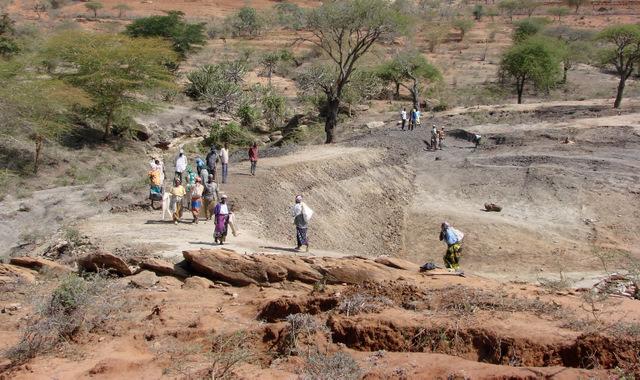
คำอธิบาย:
Small earth dams are water harvesting storage structures, constructed across narrow sections of valleys, to impound runoff generated from upstream catchment areas.
Establishment / maintenance activities and inputs: Construction of the dam wall begins with excavation of a core trench along the length of the dam wall which is filled with clay and compacted to form a ‘central core’ that anchors the wall and prevents or minimizes seepage. The upstream and downstream embankments are also built using soil with a 20-30% clay content. During construction – either by human labour, animal draught or machine (bulldozer, compacter, grader etc.) – it is critical to ensure good compaction for stability of the wall. It is common to plant Kikuyu grass (Pennisetum clandestinum) to prevent erosion of the embankment. The dam is fenced with barbed wire to prevent livestock from eroding the wall. Typical length of the embankment is 50-100 m with water depth ranging 4-8 m. An emergency spillway (vegetated or a concrete shute) is provided on either, or both sides, of the wall for safe disposal of excess water above the full supply level. The dam water has a maximum throwback of 500 m, with a capacity ranging from 50,000 – 100,000 m3.
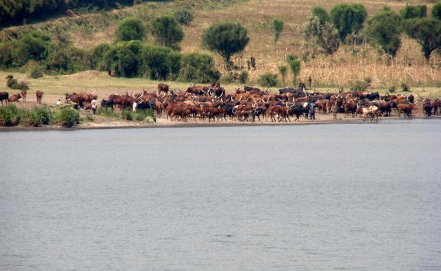
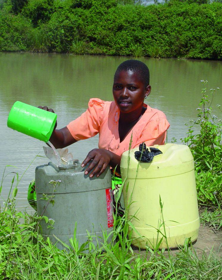
Natural / human environment: The dams are mainly used for domestic consumption, irrigation or for watering livestock. If the dams are located on communal lands, their establishment requires full consultation and involvement of the local community. The government provides technical and financial assistance for design, construction and management of these infrastructures. Community contribution includes land, labour and local resources. The community carries out periodic maintenance of the infrastructure – including vegetation management on embankment, desilting etc. – and of the catchment areas (through soil and water conservation practices).
2.3 รูปภาพของเทคโนโลยี
อัลบั้มสื่อบันทึก
2.5 ประเทศภูมิภาค หรือสถานที่ตั้งที่เทคโนโลยีได้นำไปใช้และได้รับการครอบคลุมโดยการประเมินนี้
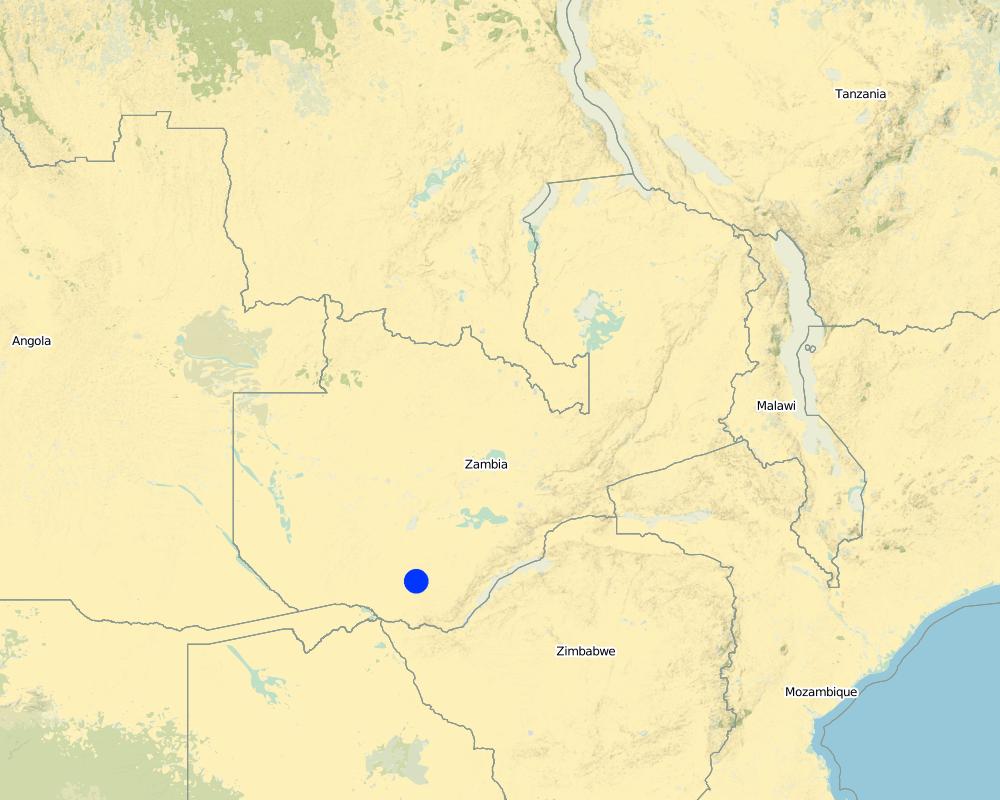
ประเทศ:
แซมเบีย
ภูมิภาค/รัฐ/จังหวัด:
Southern Province
Map
×2.6 วันที่การดำเนินการ
ถ้าไม่รู้ปีที่แน่นอน ให้ระบุวันที่โดยประมาณ:
- 10-50 ปี
2.7 คำแนะนำของเทคโนโลยี
ให้ระบุว่าเทคโนโลยีถูกแนะนำเข้ามาอย่างไร:
- ทางโครงการหรือจากภายนอก
3. การจัดประเภทของเทคโนโลยี SLM
3.1 วัตถุประสงค์หลักของเทคโนโลยี
- Access to water
3.2 ประเภทของการใช้ที่ดินในปัจจุบันที่ได้นำเทคโนโลยีไปใช้

พื้นที่ปลูกพืช
- การปลูกพืชล้มลุกอายุปีเดียว
แสดงความคิดเห็น:
Major land use problems (compiler’s opinion): water degradation, soil erosion, low surface water availability
3.3 ข้อมูลเพิ่มเติมเกี่ยวกับการใช้ที่ดิน
การใช้น้ำของที่ดินที่มีการใช้เทคโนโลยีอยู่:
- จากน้ำฝน
จำนวนของฤดูเพาะปลูกต่อปี:
- 1
ระบุ:
Longest growing period in days: 120; Longest growing period from month to month: Nov-April
3.4 กลุ่ม SLM ที่ตรงกับเทคโนโลยีนี้
- การปรับปรุงดิน / พืชคลุมดิน
- การเก็บเกี่ยวน้ำ
3.5 กระจายตัวของเทคโนโลยี
ระบุการกระจายตัวของเทคโนโลยี:
- ใช้ ณ จุดที่เฉพาะเจาะจงหรือเน้นไปยังบริเวณพื้นที่ขนาดเล็ก
แสดงความคิดเห็น:
In the study area there are over 293 dams serving a cattle population of 1.1 million and human population of nearly 1 million people
3.6 มาตรการ SLM ที่ประกอบกันเป็นเทคโนโลยี

มาตรการอนุรักษ์ด้วยวิธีพืช
- V2: หญ้าและไม้ยืนต้น

มาตรการอนุรักษ์ด้วยโครงสร้าง
- S5: เขื่อน ชั้นดินที่แน่นแข็งบ่อน้ำ
แสดงความคิดเห็น:
Secondary measures: vegetative measures
Type of vegetative measures: aligned: -contour
3.7 รูปแบบหลักของการเสื่อมโทรมของที่ดินที่ได้รับการแก้ไขโดยเทคโนโลยี

การกัดกร่อนของดินโดยน้ำ
- Wt (Loss of topsoil): การสูญเสียดินชั้นบนหรือการกัดกร่อนที่ผิวดิน
- Wg (Gully erosion): การกัดกร่อนแบบร่องธารหรือการทำให้เกิดร่องน้ำเซาะ
แสดงความคิดเห็น:
Secondary types of degradation addressed: Wg: gully erosion / gullying
Main causes of degradation: Heavy / extreme rainfall (intensity/amounts), floods
3.8 การป้องกัน การลดลง หรือการฟื้นฟูความเสื่อมโทรมของที่ดิน
ระบุเป้าหมายของเทคโนโลยีกับความเสื่อมโทรมของที่ดิน:
- ป้องกันความเสื่อมโทรมของที่ดิน
- ลดความเสื่อมโทรมของดิน
แสดงความคิดเห็น:
Secondary goals: rehabilitation / reclamation of denuded land
4. ข้อมูลจำเพาะด้านเทคนิค กิจกรรมการนำไปปฏิบัติใช้ ปัจจัยนำเข้า และค่าใช้จ่าย
4.1 แบบแปลนทางเทคนิคของเทคโนโลยี
ผู้เขียน:
Mats Gurtner, Center for Development and Environment, University of Bern
4.2 ข้อมูลจำเพาะด้านเทคนิคและการอธิบายแบบแปลนทางเทคนิค
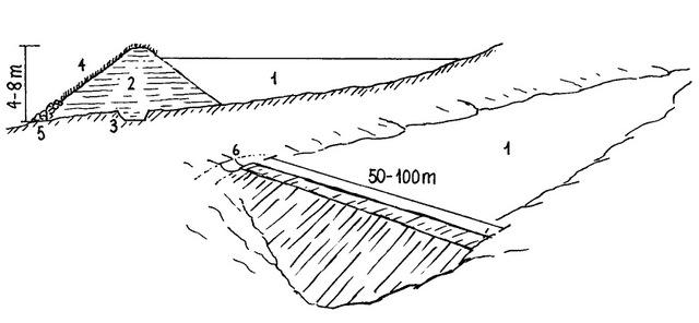
Dimensions and main components of a small dam: (1) water body; (2) dam wall (with layers of compacted soil; side slopes 3:1); (3) central core ('key'); (4) grass cover; (5) stone apron; (6) spillway
Southern Province
Technical knowledge required for field staff / advisors: high
Technical knowledge required for land users: high
Main technical functions: control of concentrated runoff: retain / trap, water harvesting / increase water supply
Aligned: -contour
Vegetative material: G : grass
Grass species: Pennisetum clandestinum
Dam/ pan/ pond
Depth of ditches/pits/dams (m): 4.00
Length of ditches/pits/dams (m): 50.00
Construction material (earth): 20-30% clay content
Specification of dams/ pans/ ponds: Capacity 100000.00m3
Dimensions of spillways: 5.00m
Vegetation is used for stabilisation of structures.
4.3 ข้อมูลทั่วไปเกี่ยวกับการคำนวณปัจจัยนำเข้าและค่าใช้จ่าย
ให้ระบุว่าค่าใช้จ่ายและปัจจัยนำเข้าได้รับการคำนวณอย่างไร:
- ต่อหน่วยเทคโนโลยี
โปรดระบุหน่วย:
Dam
ระบุปริมาตร ความยาว เป็นต้น (ถ้าเกี่ยวข้อง):
10’000 m3 (44 m long; 8 m deep)
4.4 กิจกรรมเพื่อการจัดตั้ง
| กิจกรรม | ประเภทของมาตรการ | ช่วงเวลาดำเนินการ | |
|---|---|---|---|
| 1. | Site selection in consultation with community. | ด้วยการจัดการ | |
| 2. | Dam survey and design: Topographical survey of dam area; using leveling equipment (dumpy level or theodolite); Determination of dam wall dimensions. | ด้วยการจัดการ | |
| 3. | Dam wall construction: Excavate core trench (usually 4m wide; 2m deep). Excavate and transport clay-rich soil to the dam site. Construct core and embankments (slope angles 3:1). Continuously compact placed soil. | ด้วยโครงสร้าง | |
| 4. | Construct lateral spillway(s), 5-30m wide (depending on the flood flow and the return slope). | ด้วยโครงสร้าง | |
| 5. | Design and installation of irrigation and drainage infrastructure (in case of crop production). | ด้วยโครงสร้าง | |
| 6. | Completion: plant kikuyu grass on dam embank-ment, spillway and irrigation canals and fence of; alternatively line with cement | ด้วยวิธีพืช |
4.5 ค่าใช้จ่ายของปัจจัยนำเข้าที่จำเป็นสำหรับการจัดตั้ง
| ปัจจัยนำเข้า | หน่วย | ปริมาณ | ค่าใช้จ่ายต่อหน่วย | ค่าใช้จ่ายทั้งหมดต่อปัจจัยนำเข้า | %ของค่าใช้จ่ายที่ก่อให้เกิดขึ้นโดยผู้ใช้ที่ดิน | |
|---|---|---|---|---|---|---|
| แรงงาน | Dam and spillway construction | unit | 1.0 | 2000.0 | 2000.0 | 20.0 |
| อุปกรณ์ | Tools | unit | 1.0 | 30000.0 | 30000.0 | 20.0 |
| วัสดุด้านพืช | Seeds | unit | 1.0 | 1000.0 | 1000.0 | 20.0 |
| ปุ๋ยและสารฆ่า/ยับยั้งการเจริญเติบโตของสิ่งมีชีวิต (ไบโอไซด์) | Fertilizer | unit | 1.0 | 1000.0 | 1000.0 | 20.0 |
| ปุ๋ยและสารฆ่า/ยับยั้งการเจริญเติบโตของสิ่งมีชีวิต (ไบโอไซด์) | Biocides | unit | 1.0 | 1000.0 | 1000.0 | 20.0 |
| วัสดุสำหรับก่อสร้าง | Stone | unit | 1.0 | 15000.0 | 15000.0 | 20.0 |
| ค่าใช้จ่ายทั้งหมดของการจัดตั้งเทคโนโลยี | 50000.0 | |||||
4.6 การบำรุงรักษาสภาพหรือกิจกรรมที่เกิดขึ้นเป็นประจำ
| กิจกรรม | ประเภทของมาตรการ | ช่วงระยะเวลา/ความถี่ | |
|---|---|---|---|
| 1. | Catchment conservation to minimise siltation of dam and irrigation infrastructure (continuous). | ด้วยโครงสร้าง | |
| 2. | (Re-)planting grass on dam and irrigation infrastructure (annually, using hand hoes). | ด้วยโครงสร้าง | |
| 3. | Desiliting of the dam (every 5-10 years): excavate and remove the silt deposited in the dam. | ด้วยโครงสร้าง | |
| 4. | Cleaning of dam and irrigation infra-structure (annually): remove trees/ shrubs from dam / canals. If concrete lined: repair of any damages. | ด้วยโครงสร้าง |
4.7 ค่าใช้จ่ายของปัจจัยนำเข้าและกิจกรรมที่เกิดขึ้นเป็นประจำที่ต้องการการบำรุงรักษา (ต่อปี)
| ปัจจัยนำเข้า | หน่วย | ปริมาณ | ค่าใช้จ่ายต่อหน่วย | ค่าใช้จ่ายทั้งหมดต่อปัจจัยนำเข้า | %ของค่าใช้จ่ายที่ก่อให้เกิดขึ้นโดยผู้ใช้ที่ดิน | |
|---|---|---|---|---|---|---|
| แรงงาน | Maintenance of dam | unit | 1.0 | 200.0 | 200.0 | |
| อุปกรณ์ | Tools | unit | 1.0 | 2000.0 | 2000.0 | |
| วัสดุด้านพืช | Seeds | unit | 1.0 | 300.0 | 300.0 | |
| วัสดุสำหรับก่อสร้าง | Stone | unit | 1.0 | 1500.0 | 1500.0 | |
| ค่าใช้จ่ายทั้งหมดของการบำรุงรักษาสภาพเทคโนโลยี | 4000.0 | |||||
แสดงความคิดเห็น:
Machinery/ tools: machinery, ox-ripper, hoe/pick, shovel
Establishment costs are calculated for a dam with an earthwork volume of 10’000 m3 (44 m long; 8 m deep; side slopes 3:1). 20% of costs are borne by the community (in-kind contribution: labour and local materials such as sand, stones). Construction machinery can include: tipper truck, bulldozer, motor scraper, compactor, tractor, grader
5. สิ่งแวดล้อมทางธรรมชาติและของมนุษย์
5.1 ภูมิอากาศ
ฝนประจำปี
- < 250 ม.ม.
- 251-500 ม.ม.
- 501-750 ม.ม.
- 751-1,000 ม.ม.
- 1,001-1,500 ม.ม.
- 1,501-2,000 ม.ม.
- 2,001-3,000 ม.ม.
- 3,001-4,000 ม.ม.
- > 4,000 ม.ม.
ระบุปริมาณน้ำฝนเฉลี่ยรายปี (ถ้ารู้) :หน่วย ม.ม.
700.00
เขตภูมิอากาศเกษตร
- กึ่งชุ่มชื้น
- กึ่งแห้งแล้ง
5.2 สภาพภูมิประเทศ
ค่าเฉลี่ยความลาดชัน:
- ราบเรียบ (0-2%)
- ลาดที่ไม่ชัน (3-5%)
- ปานกลาง (6-10%)
- เป็นลูกคลื่น (11-15%)
- เป็นเนิน (16-30%)
- ชัน (31-60%)
- ชันมาก (>60%)
ธรณีสัณฐาน:
- ที่ราบสูง/ที่ราบ
- สันเขา
- ไหล่เขา
- ไหล่เนินเขา
- ตีนเนิน
- หุบเขา
ระดับความสูง:
- 0-100 เมตร
- 101-500 เมตร
- 501-1,000 เมตร
- 1,001-1,500 เมตร
- 1,501-2,000 เมตร
- 2,001-2,500 เมตร
- 2,501-3,000 เมตร
- 3,001-4,000 เมตร
- > 4,000 เมตร
ความคิดเห็นและข้อมูลจำเพาะเพิ่มเติมเรื่องสภาพภูมิประเทศ:
Slopes on average: Gentle (plains), moderate (plains), rolling (plains) and hilly (valleys)
Altitudinal zone: Also 1000-1500 m a.s.l., range from 300-1200 m a.s.l.
5.3 ดิน
ค่าเฉลี่ยความลึกของดิน:
- ตื้นมาก (0-20 ซ.ม.)
- ตื้น (21-50 ซ.ม.)
- ลึกปานกลาง (51-80 ซ.ม.)
- ลึก (81-120 ซ.ม.)
- ลึกมาก (>120 ซ.ม.)
เนื้อดิน (ดินชั้นบน):
- หยาบ/เบา (ดินทราย)
- ปานกลาง (ดินร่วน ทรายแป้ง)
อินทรียวัตถุในดิน:
- ปานกลาง (1-3%)
(ถ้ามี) ให้แนบคำอธิบายเรื่องดินแบบเต็มหรือระบุข้อมูลที่มีอยู่ เช่น ชนิดของดิน ค่า pH ของดินหรือความเป็นกรดของดิน ความสามารถในการแลกเปลี่ยนประจุบวก ไนโตรเจน ความเค็ม เป็นต้น:
Soil fertility is medium
5.4 ความเป็นประโยชน์และคุณภาพของน้ำ
น้ำไหลบ่าที่ผิวดิน:
ไม่ดีหรือไม่มีเลย
5.6 ลักษณะของผู้ใช้ที่ดินที่นำเทคโนโลยีไปปฏิบัติใช้
แนวทางการตลาดของระบบการผลิต:
- ผสม (การเลี้ยงชีพ/ทำการค้า)
เป็นรายบุคคล/ครัวเรือน:
- กลุ่ม/ชุมชน
ระดับของการใช้เครื่องจักรกล:
- การใช้กำลังจากสัตว์
ระบุลักษณะอื่นๆที่เกี่ยวข้องของผู้ใช้ที่ดิน:
Land users applying the Technology are mainly disadvantaged land users
Population density: < 10 persons/km2
5.7 พื้นที่เฉลี่ยของที่ดินที่เป็นเจ้าของหรือเช่าโดยผู้ใช้ที่ดินที่นำเทคโนโลยีไปปฏิบัติใช้
- < 0.5 เฮกตาร์
- 0.5-1 เฮกตาร์
- 1-2 เฮกตาร์
- 2-5 เฮกตาร์
- 5-15 เฮกตาร์
- 15-50 เฮกตาร์
- 50-100 เฮกตาร์
- 100-500 เฮกตาร์
- 500-1,000 เฮกตาร์
- 1,000-10,000 เฮกตาร์
- >10,000 เฮกตาร์
พิจารณาว่าเป็นขนาดเล็ก กลาง หรือขนาดใหญ่ (ซึ่งอ้างอิงถึงบริบทระดับท้องถิ่น):
- ขนาดเล็ก
5.8 กรรมสิทธิ์ในที่ดิน สิทธิในการใช้ที่ดินและสิทธิในการใช้น้ำ
กรรมสิทธิ์ในที่ดิน:
- เป็นแบบชุมชนหรือหมู่บ้าน
- not titled
สิทธิในการใช้ที่ดิน:
- เกี่ยวกับชุมชน (ถูกจัดระเบียบ)
6. ผลกระทบและสรุปคำบอกกล่าว
6.1 ผลกระทบในพื้นที่ดำเนินการ (On-site) จากการใช้เทคโนโลยี
ผลกระทบทางด้านเศรษฐกิจและสังคม
การผลิต
การผลิตพืชผล
การผลิตสัตว์
ความเป็นประโยชน์และคุณภาพของน้ำ
การมีน้ำไว้ให้สำหรับการชลประทาน
คุณภาพน้ำสำหรับการชลประทาน
รายได้และค่าใช้จ่าย
รายได้จากฟาร์ม
ผลกระทบด้านสังคมวัฒนธรรมอื่น ๆ
ความมั่นคงด้านอาหาร / พึ่งตนเองได้
โอกาสทางด้านสันทนาการ
สถาบันของชุมชน
ผลกระทบด้านนิเวศวิทยา
วัฐจักรน้ำหรือน้ำบ่า
ปริมาณน้ำ
การเก็บเกี่ยวหรือการกักเก็บน้ำ
น้ำบาดาลหรือระดับน้ำในแอ่งน้ำบาดาล
ลดความเสี่ยงของภัยพิบัติ
ผลกระทบจากภัยแล้ง
6.2 ผลกระทบนอกพื้นที่ดำเนินการ (Off-site) จากการใช้เทคโนโลยี
น้ำที่ใช้ประโยชน์ได้
น้ำท่วมพื้นที่ท้ายน้ำ
6.3 การเผชิญและความตอบสนองของเทคโนโลยีต่อการเปลี่ยนแปลงสภาพภูมิอากาศที่ค่อยเป็นค่อยไป และสภาพรุนแรงของภูมิอากาศ / ภัยพิบัติ (ที่รับรู้ได้โดยผู้ใช้ที่ดิน)
การเปลี่ยนแปลงสภาพภูมิอากาศที่ค่อยเป็นค่อยไป
การเปลี่ยนแปลงสภาพภูมิอากาศที่ค่อยเป็นค่อยไป
| ฤดู | ประเภทของการเปลี่ยนแปลงสภาพภูมิอากาศที่ค่อยเป็นค่อยไป และสภาพรุนแรงของภูมิอากาศ | เทคโนโลยีมีวิธีการรับมืออย่างไร | |
|---|---|---|---|
| อุณหภูมิประจำปี | เพิ่มขึ้น | ดี |
สภาพรุนแรงของภูมิอากาศ (ภัยพิบัติ)
ภัยพิบัติทางอุตุนิยมวิทยา
| เทคโนโลยีมีวิธีการรับมืออย่างไร | |
|---|---|
| พายุฝนประจำท้องถิ่น | ไม่ค่อยดี |
| พายุลมประจำท้องถิ่น | ดี |
ภัยพิบัติจากสภาพภูมิอากาศ
| เทคโนโลยีมีวิธีการรับมืออย่างไร | |
|---|---|
| ภัยจากฝนแล้ง | ดี |
ภัยพิบัติจากน้ำ
| เทคโนโลยีมีวิธีการรับมืออย่างไร | |
|---|---|
| น้ำท่วมตามปกติ (แม่น้ำ) | ไม่ค่อยดี |
ผลลัพธ์ตามมาที่เกี่ยวข้องกับภูมิอากาศอื่น ๆ
ผลลัพธ์ตามมาที่เกี่ยวข้องกับภูมิอากาศอื่น ๆ
| เทคโนโลยีมีวิธีการรับมืออย่างไร | |
|---|---|
| ช่วงการปลูกพืชที่ลดลงมา | ดี |
6.4 การวิเคราะห์ค่าใช้จ่ายและผลประโยชน์ที่ได้รับ
ผลประโยชน์ที่ได้รับเปรียบเทียบกับค่าใช้จ่ายในการจัดตั้งเป็นอย่างไร (จากมุมมองของผู้ใช้ที่ดิน)
ผลตอบแทนระยะสั้น:
ด้านลบ
ผลตอบแทนระยะยาว:
ด้านบวกอย่างมาก
ผลประโยชน์ที่ได้รับเปรียบเทียบกับค่าใช้จ่ายในการบำรุงรักษาหรือต้นทุนที่เกิดขึ้นซ้ำอีก เป็นอย่างไร (จากมุมมองของผู้ใช้ที่ดิน)
ผลตอบแทนระยะสั้น:
เป็นกลางหรือสมดุล
ผลตอบแทนระยะยาว:
ด้านบวกอย่างมาก
6.5 การปรับตัวของเทคโนโลยี
แสดงความคิดเห็น:
Comments on adoption trend: Records of 1991 indicate at least 537 such dams exist in Zambia. In the study area there are over 293 dams serving a cattle population of 1.1 million and human population of nearly 1 million people.
6.7 จุดแข็ง / ข้อได้เปรียบ / โอกาสของเทคโนโลยี
| จุดแข็ง / ข้อได้เปรียบ / โอกาสในทัศนคติของผู้รวบรวมหรือวิทยากรหลัก |
|---|
|
Small earth dams allow for the diversification of income activities including tree nurseries, brick making, fish farming, raising ducks and geese and thus alleviate poverty improvement of access to markets will be crucial to support such income generating activities |
|
Saves people’s time by reducing the distance to fetch water for domestic use clear and equitable water use rights and agreements |
|
Reduced risk of crop failure by bridging prolonged dry periods and as such contribute to food security and climate change adaptation How can they be sustained / enhanced? combine with water saving cultivation practices such as mulching, pitting etc. |
|
Reduced damages from soil erosion and flooding by storing excessive runoff water How can they be sustained / enhanced? use an integrated watershed management approach to reduce flood and erosion risk |
|
Possibility for watering cattle near the village reduced soil compaction and erosion How can they be sustained / enhanced? regulate access of cattle to avoid degradation around the water source and protect water source from pollution |
6.8 จุดอ่อน / ข้อเสียเปรียบ / ความเสี่ยงของเทคโนโลยีและวิธีการแก้ไข
| จุดอ่อน / ข้อเสียเปรียบ / ความเสี่ยงในทัศนคติของผู้รวบรวมหรือวิทยากรหลัก | มีวิธีการแก้ไขได้อย่างไร |
|---|---|
| Dams are communally owned | requires strong organisation and commitment by community |
| Risk of siltation | de-silting and Catchment conservation is essential |
| Vulnerability to climate change | increase depth and design storage to last at least for two rainy seasons |
| Evaporation and seepage losses | maintain minimum design depth of 4 meters; if seepage is high: provide impervious material on the upstream embankment, i.e. clay or plastic lining if necessary |
7. การอ้างอิงและการเชื่อมต่อ
7.2 การอ้างอิงถึงสิ่งตีพิมพ์
หัวข้อ, ผู้เขียน, ปี, หมายเลข ISBN:
Nissen-Petersen E. 2006. Water from small dams. A handbook for technicians, farmers and others on site investigations, designs, cost estimations, construction and maintenance of small earth dams
หัวข้อ, ผู้เขียน, ปี, หมายเลข ISBN:
Morris P. H. 1991. Statement of Policy: Progress Review of the Drought Relief Dam Cons/ruction Project, Southern Province. Part 1 — Main Report. Irrigation and Land Husbandry Branch, Department of Agriculture, Chôma
หัวข้อ, ผู้เขียน, ปี, หมายเลข ISBN:
Sichingabula H.M. 1997. Problems of sedimentation in small dams in Zambia. Human Impact on Erosion and Sedimentation (Proceedings of the Rabat Symposium, April 1997. IAHS Publ. no. 245, 1997
7.3 เชื่อมโยงกับข้อมูลที่มีอยู่บนออนไลน์
ชื่อเรื่องหรือคำอธิบาย:
The Jesuit Centre for Theological Reflection. 2010. Social Conditions Programme.
URL:
http://www.mywage.org/zambia/main/minimum-wage/comparitive-minimum-wage
ลิงก์และโมดูล
ขยายทั้งหมด ย่อทั้งหมดลิงก์
ไม่มีลิงก์
โมดูล
ไม่มีโมดูล