Boundary Trees-Windbreakers [เคนยา]
- ผู้สร้างสรรค์:
- การอัพเดท:
- ผู้รวบรวม: Paul Kahiga
- ผู้เรียบเรียง: –
- ผู้ตรวจสอบ: Deborah Niggli, Alexandra Gavilano
Windbreaker
technologies_1738 - เคนยา
ดูส่วนย่อย
ขยายทั้งหมด ย่อทั้งหมด1. ข้อมูลทั่วไป
1.2 รายละเอียดที่ติดต่อได้ของผู้รวบรวมและองค์กรที่เกี่ยวข้องในการประเมินและการจัดเตรียมทำเอกสารของเทคโนโลยี
Gathenya Mwangi
Jomo Kenyatta University of Agriculture and Technology
เคนยา
ผู้เชี่ยวชาญ SLM:
Home Patrick
Jomo Kenyatta University of Agriculture and Technology
เคนยา
ผู้เชี่ยวชาญ SLM:
Chege Timothy
Jomo Kenyatta University of Agriculture and Technology
เคนยา
ผู้เชี่ยวชาญ SLM:
Abamba Omwange
Jomo Kenyatta University of Agriculture and Technology
เคนยา
ผู้เชี่ยวชาญ SLM:
Baobab Kimengich
Jomo Kenyatta University of Agriculture and Technology
เคนยา
ผู้เชี่ยวชาญ SLM:
Wamuongo Jane
Kenya Agricultural Research Institute
เคนยา
ผู้เชี่ยวชาญ SLM:
Karanja Andrew
Kenya Agricultural Research Institute
เคนยา
ผู้เชี่ยวชาญ SLM:
Namirembe Sarah
World Agroforestry Centre - ICRAF
เคนยา
ชื่อขององค์กรซึ่งอำนวยความสะดวกในการทำเอกสารหรือการประเมินเทคโนโลยี (ถ้าเกี่ยวข้อง)
Jomo Kenyatta University (Jomo Kenyatta University) - เคนยาชื่อขององค์กรซึ่งอำนวยความสะดวกในการทำเอกสารหรือการประเมินเทคโนโลยี (ถ้าเกี่ยวข้อง)
KARI Headquarters (KARI Headquarters) - เคนยาชื่อขององค์กรซึ่งอำนวยความสะดวกในการทำเอกสารหรือการประเมินเทคโนโลยี (ถ้าเกี่ยวข้อง)
International Centre for Research in Agroforestry (ICRAF) - เคนยา1.3 เงื่อนไขการใช้ข้อมูลที่ได้บันทึกผ่านทาง WOCAT
ผู้รวบรวมและวิทยากรหลักยอมรับเงื่อนไขเกี่ยวกับการใช้ข้อมูลที่ถูกบันทึกผ่านทาง WOCAT:
ใช่
1.4 การเปิดเผยเรื่องความยั่งยืนของเทคโนโลยีที่ได้อธิบายไว้
เทคโนโลยีที่ได้อธิบายไว้นี้เป็นปัญหาของความเสื่อมโทรมโทรมของที่ดินหรือไม่ จึงไม่ได้รับการยอมรับว่าเป็นเทคโนโลยีเพื่อการจัดการที่ดินอย่างยั่งยืน:
ไม่ใช่
2. การอธิบายลักษณะของเทคโนโลยี SLM
2.1 การอธิบายแบบสั้น ๆ ของเทคโนโลยี
คำจำกัดความของเทคโนโลยี:
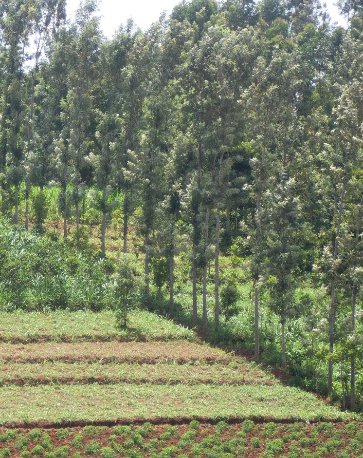
Windbreaks are narrow strips of trees, shrubs and/or grasses planted to protect fields, homes, canals, and other areas from the wind and blowing sand.
2.2 การอธิบายแบบละเอียดของเทคโนโลยี
คำอธิบาย:
Where wind is a major cause of soil erosion and moisture loss, windbreaks can make a significant contribution to sustainable production. They also be used to act as shelter-belts, a type of windbreak, are long, multiple rows of trees and shrubs, usually along sea coasts, to protect agricultural fields from inundation by tidal waves.
Purpose of the Technology: Windbreaks can make a significant contribution to sustainable production
Where wind is a major cause of soil erosion and moisture loss
It improves the microclimate in a given protected area by decreasing water evaporation from the soil and plants
Establishment / maintenance activities and inputs: Trees ( mainly Grivelia robusta) are planted in rows. They are maintained by regular pruning from the tender age to old age. Also, regular replacement of old trees. The trees are closely planted, about 1m apart and a maximum height of about 10m. The trees are always planted along the edges of the fields to protect the effects of mainly wind and the tidal waves. Surveying of the planting lines should be done to ensure they are linear
Natural / human environment: The trees are used as boundaries, firewood, timber and fence posts, they should be environmental friendly.
2.3 รูปภาพของเทคโนโลยี
อัลบั้มสื่อบันทึก
2.5 ประเทศภูมิภาค หรือสถานที่ตั้งที่เทคโนโลยีได้นำไปใช้และได้รับการครอบคลุมโดยการประเมินนี้
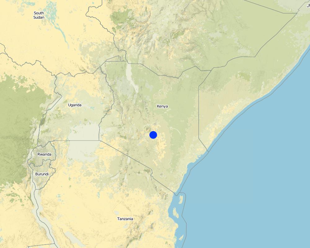
ประเทศ:
เคนยา
ภูมิภาค/รัฐ/จังหวัด:
Eastern Province
ข้อมูลจำเพาะเพิ่มเติมของสถานที่ตั้ง :
Mbeere South District
ระบุการกระจายตัวของเทคโนโลยี:
- กระจายไปอย่างสม่ำเสมอในพื้นที่
If precise area is not known, indicate approximate area covered:
- 0.1-1 ตร.กม.
Map
×2.6 วันที่การดำเนินการ
ถ้าไม่รู้ปีที่แน่นอน ให้ระบุวันที่โดยประมาณ:
- 10-50 ปี
2.7 คำแนะนำของเทคโนโลยี
ให้ระบุว่าเทคโนโลยีถูกแนะนำเข้ามาอย่างไร:
- ด้วยการริเริ่มของผู้ใช้ที่ดินเอง
3. การจัดประเภทของเทคโนโลยี SLM
3.1 วัตถุประสงค์หลักของเทคโนโลยี
- ปรับปรุงการผลิตให้ดีขึ้น
- ลด ป้องกัน ฟื้นฟู การเสื่อมโทรมของที่ดิน
- ปรับตัวเข้ากับการเปลี่ยนแปลงภูมิอากาศของโลก สภาพภูมิอากาศที่รุนแรงและผลกระทบ
- สร้างผลกระทบทางด้านเศรษฐกิจที่เป็นประโยชน์
3.2 ประเภทของการใช้ที่ดินในปัจจุบันที่ได้นำเทคโนโลยีไปใช้

พื้นที่ปลูกพืช
- การปลูกพืชล้มลุกอายุปีเดียว
จำนวนของฤดูเพาะปลูกต่อปี:
- 2

ป่า/พื้นที่ทำไม้
- ป่า/พื้นที่ทำไม้
Type of tree:
- Grevillea robusta
ผลิตภัณฑ์และบริการ:
- การอนุรักษ์ / ป้องกันธรรมชาติ
- การป้องกันภัยธรรมชาติ
แสดงความคิดเห็น:
Major land use problems (compiler’s opinion): There is a lot of wind erosion that leads to low land productivity.
Major land use problems (land users’ perception): Soil erosion of the top soil.
Future (final) land use (after implementation of SLM Technology): Cropland: Ca: Annual cropping
3.3 Has land use changed due to the implementation of the Technology?
พื้นที่ปลูกพืช
- การปลูกพืชล้มลุกอายุปีเดียว
3.4 การใช้น้ำ
การใช้น้ำของที่ดินที่มีการใช้เทคโนโลยีอยู่:
- น้ำฝนร่วมกับการชลประทาน
3.5 กลุ่ม SLM ที่ตรงกับเทคโนโลยีนี้
- แนวกันลมหรือแนวต้านลม
3.6 มาตรการ SLM ที่ประกอบกันเป็นเทคโนโลยี

มาตรการอนุรักษ์ด้วยวิธีพืช
- V1: ต้นไม้และพุ่มไม้คลุมดิน
แสดงความคิดเห็น:
Type of vegetative measures: aligned: -along boundary
3.7 รูปแบบหลักของการเสื่อมโทรมของที่ดินที่ได้รับการแก้ไขโดยเทคโนโลยี

การกัดกร่อนของดินโดยลม
- Et (Loss of topsoil): การสูญเสียดินชั้นบน
แสดงความคิดเห็น:
Main causes of degradation: wind storms / dust storms
Secondary causes of degradation: soil management, crop management (annual, perennial, tree/shrub), droughts, land tenure
3.8 การป้องกัน การลดลง หรือการฟื้นฟูความเสื่อมโทรมของที่ดิน
ระบุเป้าหมายของเทคโนโลยีกับความเสื่อมโทรมของที่ดิน:
- ป้องกันความเสื่อมโทรมของที่ดิน
- ฟื้นฟูบำบัดที่ดินที่เสื่อมโทรมลงอย่างมาก
4. ข้อมูลจำเพาะด้านเทคนิค กิจกรรมการนำไปปฏิบัติใช้ ปัจจัยนำเข้า และค่าใช้จ่าย
4.1 แบบแปลนทางเทคนิคของเทคโนโลยี
ข้อมูลจำเพาะด้านเทคนิค (แบบแปลนทางเทคนิคของเทคโนโลยี):
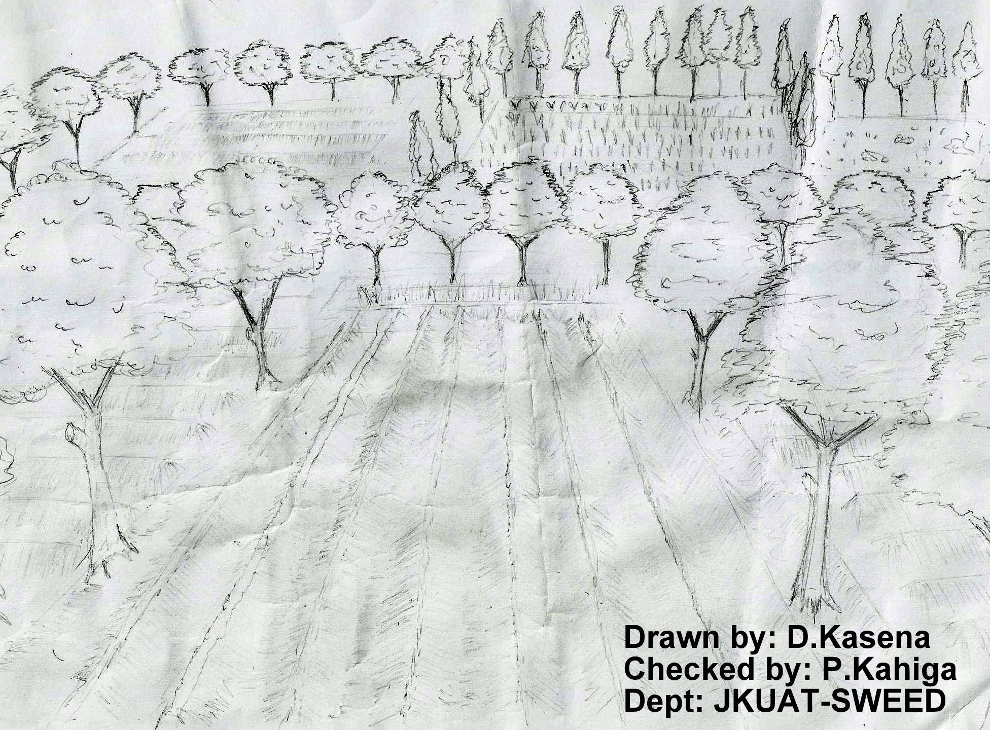
The technical drawing on the left hand shows boundary trees planted either along boundaries between farmers or between different portions of two crop stands. The spacing between the crops depend on the type of particular tree. The most common boundary trees used in Embu County is gravellia trees that have multiple uses (firewood, timber, animal feeds - leaves during the dry spells and mulch to some extent)
Location: Embu. Central Province
Date: 13.02.2013
Technical knowledge required for field staff / advisors: moderate (The technology does not require a lot of skills to demonstrate to the farmers. Just basic skills on spacing and vertical interval)
Technical knowledge required for land users: low (The basic skills of the farmer required to effect the technology)
Main technical functions: stabilisation of soil (eg by tree roots against land slides), reduction in wind speed
Aligned: -contour
Vegetative material: T : trees / shrubs
Aligned: -along boundary
Vegetative material: T : trees / shrubs
Number of plants per (ha): 400
Vertical interval between rows / strips / blocks (m): 20
Spacing between rows / strips / blocks (m): 5
Vertical interval within rows / strips / blocks (m): 0.3
Width within rows / strips / blocks (m): 0.5
Trees/ shrubs species: Grivelia robusta
Grass species: Napier grass
Slope (which determines the spacing indicated above): 5%%
If the original slope has changed as a result of the Technology, the slope today is (see figure below): 5%%
ผู้เขียน:
Paul Kahiga, 8444-00300, Nairobi-Kenya
4.2 ข้อมูลทั่วไปเกี่ยวกับการคำนวณปัจจัยนำเข้าและค่าใช้จ่าย
อื่นๆ หรือสกุลเงินประจำชาติ (ระบุ):
KSh
If relevant, indicate exchange rate from USD to local currency (e.g. 1 USD = 79.9 Brazilian Real): 1 USD =:
85.0
ระบุค่าเฉลี่ยของค่าจ้างในการจ้างแรงงานต่อวัน:
4.70
4.3 กิจกรรมเพื่อการจัดตั้ง
| กิจกรรม | Timing (season) | |
|---|---|---|
| 1. | Establishing contours | Each cropping season |
| 2. | Digging of holes | Before the cropping season |
| 3. | Planting of trees | After the digging of holes |
4.4 ค่าใช้จ่ายของปัจจัยนำเข้าที่จำเป็นสำหรับการจัดตั้ง
| ปัจจัยนำเข้า | หน่วย | ปริมาณ | ค่าใช้จ่ายต่อหน่วย | ค่าใช้จ่ายทั้งหมดต่อปัจจัยนำเข้า | %ของค่าใช้จ่ายที่ก่อให้เกิดขึ้นโดยผู้ใช้ที่ดิน | |
|---|---|---|---|---|---|---|
| แรงงาน | Labour | ha | 1.0 | 470.0 | 470.0 | 100.0 |
| อุปกรณ์ | Tools | ha | 1.0 | 5.3 | 5.3 | 100.0 |
| วัสดุด้านพืช | Seedlings | ha | 1.0 | 480.0 | 480.0 | 100.0 |
| ปุ๋ยและสารฆ่า/ยับยั้งการเจริญเติบโตของสิ่งมีชีวิต (ไบโอไซด์) | Compost/manure | ha | 1.0 | 3.5 | 3.5 | 100.0 |
| ค่าใช้จ่ายทั้งหมดของการจัดตั้งเทคโนโลยี | 958.8 | |||||
| Total costs for establishment of the Technology in USD | 11.28 | |||||
แสดงความคิดเห็น:
Duration of establishment phase: 24 month(s)
4.5 การบำรุงรักษาสภาพหรือกิจกรรมที่เกิดขึ้นเป็นประจำ
| กิจกรรม | ช่วงระยะเวลา/ความถี่ | |
|---|---|---|
| 1. | Prunning | Each cropping season |
| 2. | Pruning | Onset of planting season |
4.6 ค่าใช้จ่ายของปัจจัยนำเข้าและกิจกรรมที่เกิดขึ้นเป็นประจำที่ต้องการการบำรุงรักษา (ต่อปี)
| ปัจจัยนำเข้า | หน่วย | ปริมาณ | ค่าใช้จ่ายต่อหน่วย | ค่าใช้จ่ายทั้งหมดต่อปัจจัยนำเข้า | %ของค่าใช้จ่ายที่ก่อให้เกิดขึ้นโดยผู้ใช้ที่ดิน | |
|---|---|---|---|---|---|---|
| แรงงาน | Labour | ha | 1.0 | 470.0 | 470.0 | 100.0 |
| ค่าใช้จ่ายทั้งหมดของการบำรุงรักษาสภาพเทคโนโลยี | 470.0 | |||||
| Total costs for maintenance of the Technology in USD | 5.53 | |||||
4.7 ปัจจัยสำคัญที่สุดที่มีผลกระทบต่อค่าใช้จ่าย
ปัจจัยสำคัญที่สุดที่มีผลกระทบต่อค่าใช้จ่ายต่างๆ:
If the land has a gentle sloping gradient, the trees need to be closely planted o reduce the effects of the winds and storms to the crops.
5. สิ่งแวดล้อมทางธรรมชาติและของมนุษย์
5.1 ภูมิอากาศ
ฝนประจำปี
- < 250 ม.ม.
- 251-500 ม.ม.
- 501-750 ม.ม.
- 751-1,000 ม.ม.
- 1,001-1,500 ม.ม.
- 1,501-2,000 ม.ม.
- 2,001-3,000 ม.ม.
- 3,001-4,000 ม.ม.
- > 4,000 ม.ม.
ข้อมูลจำเพาะ/ความคิดเห็นเรื่องปริมาณน้ำฝน:
The area receives relatively good amount of rainfall
เขตภูมิอากาศเกษตร
- กึ่งชุ่มชื้น
- กึ่งแห้งแล้ง
5.2 สภาพภูมิประเทศ
ค่าเฉลี่ยความลาดชัน:
- ราบเรียบ (0-2%)
- ลาดที่ไม่ชัน (3-5%)
- ปานกลาง (6-10%)
- เป็นลูกคลื่น (11-15%)
- เป็นเนิน (16-30%)
- ชัน (31-60%)
- ชันมาก (>60%)
ธรณีสัณฐาน:
- ที่ราบสูง/ที่ราบ
- สันเขา
- ไหล่เขา
- ไหล่เนินเขา
- ตีนเนิน
- หุบเขา
ระดับความสูง:
- 0-100 เมตร
- 101-500 เมตร
- 501-1,000 เมตร
- 1,001-1,500 เมตร
- 1,501-2,000 เมตร
- 2,001-2,500 เมตร
- 2,501-3,000 เมตร
- 3,001-4,000 เมตร
- > 4,000 เมตร
5.3 ดิน
ค่าเฉลี่ยความลึกของดิน:
- ตื้นมาก (0-20 ซ.ม.)
- ตื้น (21-50 ซ.ม.)
- ลึกปานกลาง (51-80 ซ.ม.)
- ลึก (81-120 ซ.ม.)
- ลึกมาก (>120 ซ.ม.)
เนื้อดิน (ดินชั้นบน):
- ปานกลาง (ดินร่วน ทรายแป้ง)
อินทรียวัตถุในดิน:
- ปานกลาง (1-3%)
(ถ้ามี) ให้แนบคำอธิบายเรื่องดินแบบเต็มหรือระบุข้อมูลที่มีอยู่ เช่น ชนิดของดิน ค่า pH ของดินหรือความเป็นกรดของดิน ความสามารถในการแลกเปลี่ยนประจุบวก ไนโตรเจน ความเค็ม เป็นต้น:
Soil texture: Medium (the soils are relatively friable)
Soil fertility: Medium (limited crops for productivity)
Topsoil organic matter: Medium (gently sloping lands)
Soil drainage/infiltration: Medium (the soils are relatively good drained)
Soil water storage capacity: Medium (soils have medium water holding capacity due to high intensities of sun rays)
5.4 ความเป็นประโยชน์และคุณภาพของน้ำ
ระดับน้ำใต้ดิน:
> 50 เมตร
น้ำไหลบ่าที่ผิวดิน:
ปานกลาง
คุณภาพน้ำ (ที่ยังไม่ได้บำบัด):
เป็นน้ำเพื่อการดื่มที่ไม่ดี (จำเป็นต้องได้รับการบำบัด)
5.5 ความหลากหลายทางชีวภาพ
ความหลากหลายทางชนิดพันธุ์:
- ต่ำ
5.6 ลักษณะของผู้ใช้ที่ดินที่นำเทคโนโลยีไปปฏิบัติใช้
แนวทางการตลาดของระบบการผลิต:
- mixed (subsistence/ commercial)
รายได้ที่มาจากนอกฟาร์ม:
- 10-50% ของรายได้ทั้งหมด
ระดับของความมั่งคั่งโดยเปรียบเทียบ:
- พอมีพอกิน
เป็นรายบุคคล/ครัวเรือน:
- เป็นรายบุคคล/ครัวเรือน
ระดับของการใช้เครื่องจักรกล:
- งานที่ใช้แรงกาย
เพศ:
- หญิง
- ชาย
ระบุลักษณะอื่นๆที่เกี่ยวข้องของผู้ใช้ที่ดิน:
Land users applying the Technology are mainly common / average land users
Difference in the involvement of women and men: Men ensure establishment and women ensure good maintenance of the technology
Population density: > 500 persons/km2
Annual population growth: 1% - 2%
(Most people have avaragely living standards).
Off-farm income specification: There is increased production since the trees once grown big can be cut and provide timber
5.7 Average area of land used by land users applying the Technology
- < 0.5 เฮกตาร์
- 0.5-1 เฮกตาร์
- 1-2 เฮกตาร์
- 2-5 เฮกตาร์
- 5-15 เฮกตาร์
- 15-50 เฮกตาร์
- 50-100 เฮกตาร์
- 100-500 เฮกตาร์
- 500-1,000 เฮกตาร์
- 1,000-10,000 เฮกตาร์
- >10,000 เฮกตาร์
พิจารณาว่าเป็นขนาดเล็ก กลาง หรือขนาดใหญ่ (ซึ่งอ้างอิงถึงบริบทระดับท้องถิ่น):
- ขนาดเล็ก
5.8 กรรมสิทธิ์ในที่ดิน สิทธิในการใช้ที่ดินและสิทธิในการใช้น้ำ
กรรมสิทธิ์ในที่ดิน:
- รายบุคคล ไม่ได้รับสิทธิครอบครอง
สิทธิในการใช้ที่ดิน:
- รายบุคคล
5.9 การเข้าถึงบริการและโครงสร้างพื้นฐาน
สุขภาพ:
- จน
- ปานกลาง
- ดี
การศึกษา:
- จน
- ปานกลาง
- ดี
6. ผลกระทบและสรุปคำบอกกล่าว
6.1 ผลกระทบในพื้นที่ดำเนินการ (On-site) จากการใช้เทคโนโลยี
ผลกระทบทางด้านเศรษฐกิจและสังคม
การผลิต
การผลิตไม้
ความหลากหลายของผลิตภัณฑ์
การจัดการที่ดิน
รายได้และค่าใช้จ่าย
รายได้จากฟาร์ม
ผลกระทบด้านสังคมวัฒนธรรมอื่น ๆ
SLM หรือความรู้เรื่องความเสื่อมโทรมของที่ดิน
การบรรเทาความขัดแย้ง
Improved livelihoods and human well-being
ผลกระทบด้านนิเวศวิทยา
ความหลากหลายทางชีวภาพของพืชและสัตว์
ความหลากหลายของสัตว์
ลดความเสี่ยงของภัยพิบัติ
ความเร็วของลม
6.2 ผลกระทบนอกพื้นที่ดำเนินการ (Off-site) จากการใช้เทคโนโลยี
ตะกอนที่ถูกพัดพามาโดยลม
6.3 การเผชิญและความตอบสนองของเทคโนโลยีต่อการเปลี่ยนแปลงสภาพภูมิอากาศที่ค่อยเป็นค่อยไป และสภาพรุนแรงของภูมิอากาศ / ภัยพิบัติ (ที่รับรู้ได้โดยผู้ใช้ที่ดิน)
สภาพรุนแรงของภูมิอากาศ (ภัยพิบัติ)
ภัยพิบัติทางอุตุนิยมวิทยา
| เทคโนโลยีมีวิธีการรับมืออย่างไร | |
|---|---|
| พายุลมประจำท้องถิ่น | ดี |
6.4 การวิเคราะห์ค่าใช้จ่ายและผลประโยชน์ที่ได้รับ
ผลประโยชน์ที่ได้รับเปรียบเทียบกับค่าใช้จ่ายในการจัดตั้งเป็นอย่างไร (จากมุมมองของผู้ใช้ที่ดิน)
ผลตอบแทนระยะสั้น:
ด้านบวก
ผลตอบแทนระยะยาว:
ด้านบวก
ผลประโยชน์ที่ได้รับเปรียบเทียบกับค่าใช้จ่ายในการบำรุงรักษาหรือต้นทุนที่เกิดขึ้นซ้ำอีก เป็นอย่างไร (จากมุมมองของผู้ใช้ที่ดิน)
ผลตอบแทนระยะสั้น:
ด้านบวก
ผลตอบแทนระยะยาว:
ด้านบวก
6.5 การปรับตัวของเทคโนโลยี
แสดงความคิดเห็น:
There is a strong trend towards spontaneous adoption of the Technology
6.7 จุดแข็ง / ข้อได้เปรียบ / โอกาสของเทคโนโลยี
| จุดแข็ง / ข้อได้เปรียบ / โอกาสในทัศนคติของผู้รวบรวมหรือวิทยากรหลัก |
|---|
| Reduce wind speed |
| They produce fruit, nuts, maple syrup, firewood, posts, poles and veneer |
| They provide nectar and pollen for bees |
| Wind breaks protect a variety of wind-sensitive crops |
| Acts as sound barriers and mitigate odors from neighboring properties |
6.8 จุดอ่อน / ข้อเสียเปรียบ / ความเสี่ยงของเทคโนโลยีและวิธีการแก้ไข
| จุดอ่อน / ข้อเสียเปรียบ / ความเสี่ยงในทัศนคติของผู้ใช้ที่ดิน | มีวิธีการแก้ไขได้อย่างไร |
|---|---|
| complicates equipment movement | Proper spacing to allow movement of equipment |
| Establishment and maintenance costs | The establishment and maintenance cost cant be equaled with the overall benefits |
| จุดอ่อน / ข้อเสียเปรียบ / ความเสี่ยงในทัศนคติของผู้รวบรวมหรือวิทยากรหลัก | มีวิธีการแก้ไขได้อย่างไร |
|---|---|
| Loss of space that could otherwise be utilized by food crops | Appropriate spacing even though the effect has less magnitude because it is established along the boundaries |
| Shading effects, effects on micro-climate and harbors pests. | Avoid very tall windbreaks which shades excessively and are susceptible to breakages. Use of appropriate chemicals for spraying the pests. |
| Competition for water and nutrients | Supplemental irrigation in times of droughts |
7. การอ้างอิงและการเชื่อมต่อ
7.1 วิธีการและแหล่งข้อมูล
- ไปเยี่ยมชมภาคสนาม การสำรวจพื้นที่ภาคสนาม
- การสัมภาษณ์กับผู้ใช้ที่ดิน
วันที่เก็บรวบรวมข้อมูล(ภาคสนาม) :
18/09/2012
ลิงก์และโมดูล
ขยายทั้งหมด ย่อทั้งหมดลิงก์
ไม่มีลิงก์
โมดูล
ไม่มีโมดูล