Gully control and catchment protection [โบลิเวีย]
- ผู้สร้างสรรค์:
- การอัพเดท:
- ผู้รวบรวม: Georg Heim
- ผู้เรียบเรียง: –
- ผู้ตรวจสอบ: Fabian Ottiger, Alexandra Gavilano
Control de cárcavas (spanish)
technologies_1350 - โบลิเวีย
ดูส่วนย่อย
ขยายทั้งหมด ย่อทั้งหมด1. ข้อมูลทั่วไป
1.2 รายละเอียดที่ติดต่อได้ของผู้รวบรวมและองค์กรที่เกี่ยวข้องในการประเมินและการจัดเตรียมทำเอกสารของเทคโนโลยี
ผู้เชี่ยวชาญ SLM:
Vargas Ivan
โบลิเวีย
ชื่อของโครงการซึ่งอำนวยความสะดวกในการทำเอกสารหรือการประเมินเทคโนโลยี (ถ้าเกี่ยวข้อง)
Book project: where the land is greener - Case Studies and Analysis of Soil and Water Conservation Initiatives Worldwide (where the land is greener)ชื่อขององค์กรซึ่งอำนวยความสะดวกในการทำเอกสารหรือการประเมินเทคโนโลยี (ถ้าเกี่ยวข้อง)
GEOTEST AG (GEOTEST AG) - สวิตเซอร์แลนด์1.3 เงื่อนไขการใช้ข้อมูลที่ได้บันทึกผ่านทาง WOCAT
ผู้รวบรวมและวิทยากรหลักยอมรับเงื่อนไขเกี่ยวกับการใช้ข้อมูลที่ถูกบันทึกผ่านทาง WOCAT:
ใช่
1.4 การเปิดเผยเรื่องความยั่งยืนของเทคโนโลยีที่ได้อธิบายไว้
เทคโนโลยีที่ได้อธิบายไว้นี้เป็นปัญหาของความเสื่อมโทรมโทรมของที่ดินหรือไม่ จึงไม่ได้รับการยอมรับว่าเป็นเทคโนโลยีเพื่อการจัดการที่ดินอย่างยั่งยืน:
ไม่ใช่
1.5 Reference to Questionnaire(s) on SLM Approaches (documented using WOCAT)
Incentive-based catchment treatment [โบลิเวีย]
A project supported, incentive-based approach: farmers are sensitised about erosion, and involved in gully control and other measures to protect catchments.
- ผู้รวบรวม: Unknown User
2. การอธิบายลักษณะของเทคโนโลยี SLM
2.1 การอธิบายแบบสั้น ๆ ของเทคโนโลยี
คำจำกัดความของเทคโนโลยี:
Integrated gully treatment consisting of several simple practices including stone and wooden check dams, cut-off drains and reforestation in sediment traps (biotrampas).
2.2 การอธิบายแบบละเอียดของเทคโนโลยี
คำอธิบาย:
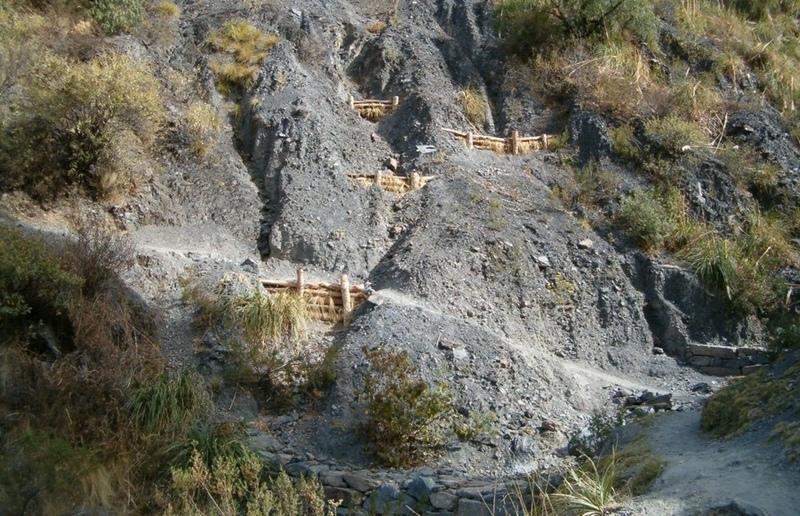
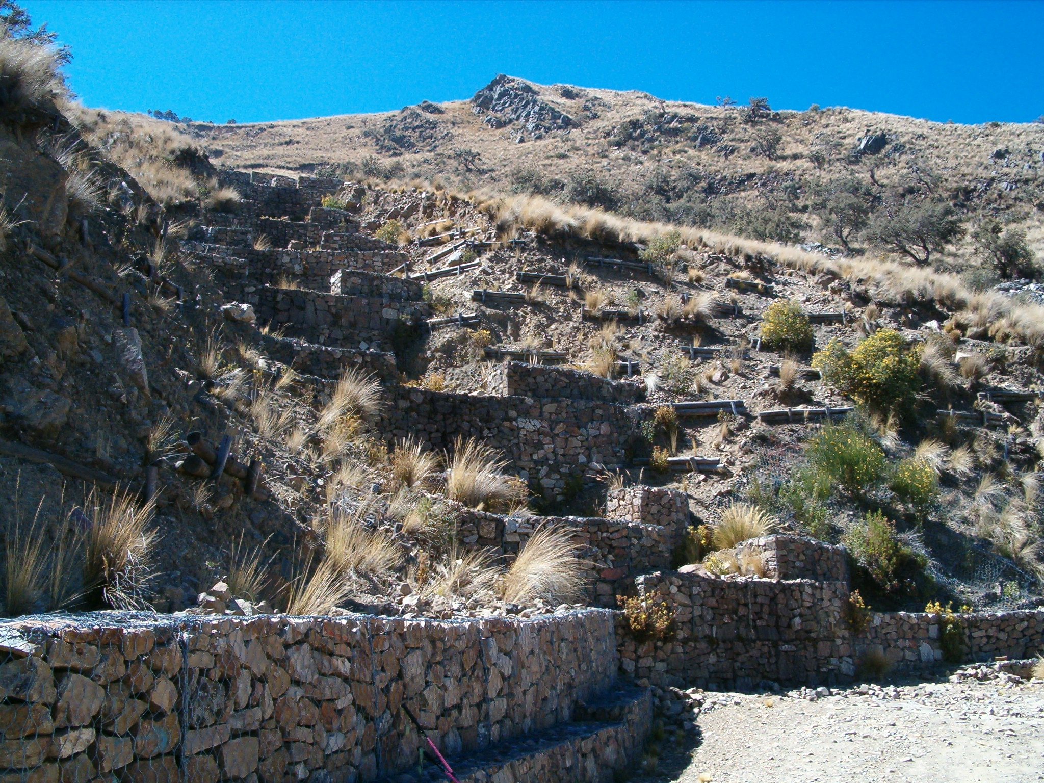
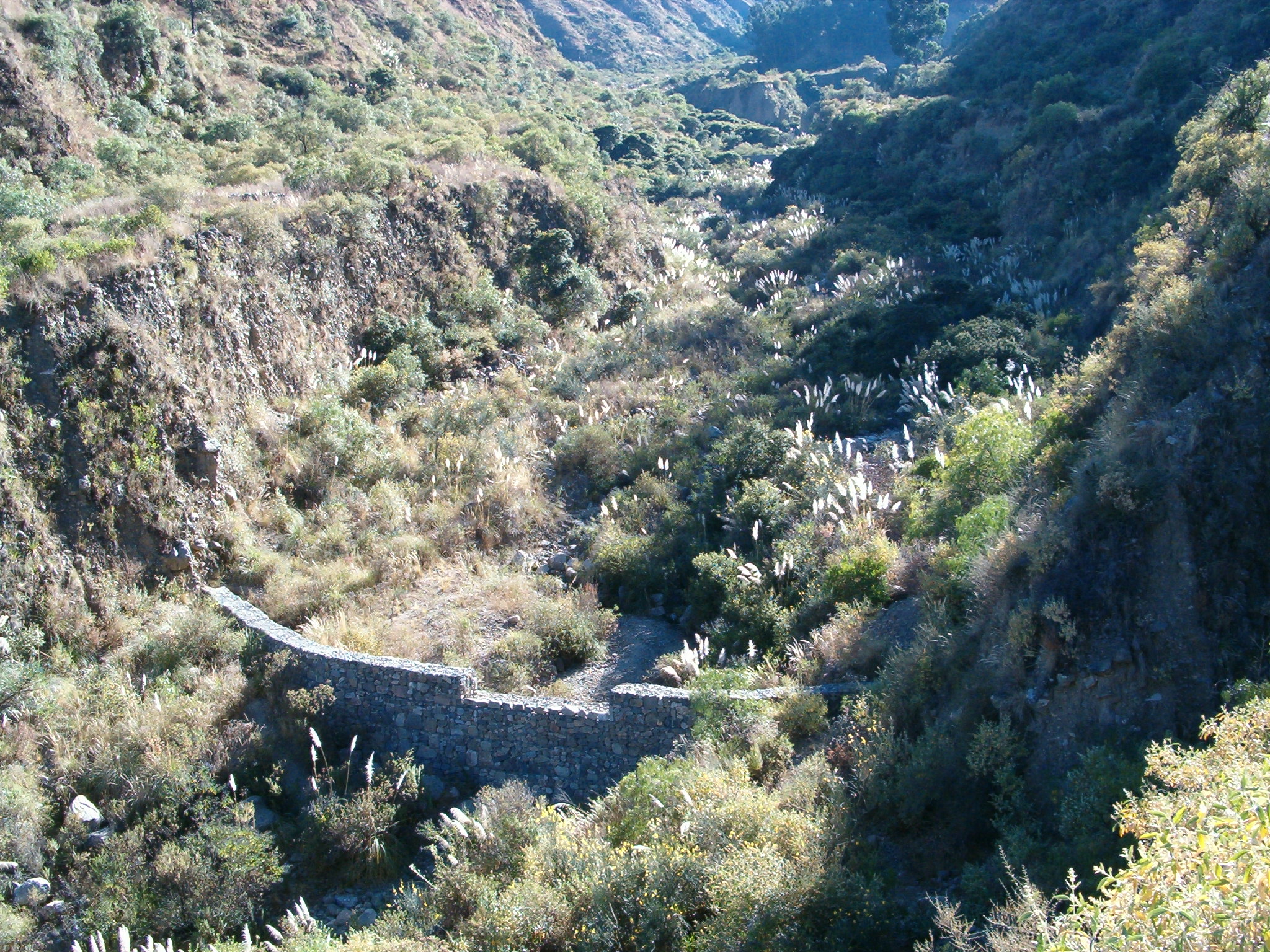
The focus of the case study is a degraded catchment, located at high altitude (2,800–4,200 m a.s.l.), home to 37 households, which is characterised by severe gullies and landslides. Gullies are continuously expanding, and constitute a significant proportion of the catchment. These cause considerable loss of cropland as well as downstream damage to the city of Cochabamba.
A combination of structural and vegetative measures was designed and implemented with the purpose of: (1) preventing affected areas from further degradation by safely discharging runoff from the surrounding area through the main gullies down to the valley; (2) gradually stabilising the land through the regeneration of vegetative cover; (3) reducing downstream damage through floods and siltation; (4) ensuring accessibility to the mountainous agricultural area during the rainy season.
Cut-off drains at the heads of the gullies, reinforced with stones inside the channel and grassed bunds below, concentrate runoff and cascade it down over stone steps back into the waterways. Flow is controlled by stone and wooden check dams and discharged safely. Sediment is trapped behind these structures and terraces develop. Bushes or trees are planted above and below the check dams. Depending on availability of materials, wooden check dams are sometimes used and associated with tree planting (four trees above and four below each check dam).
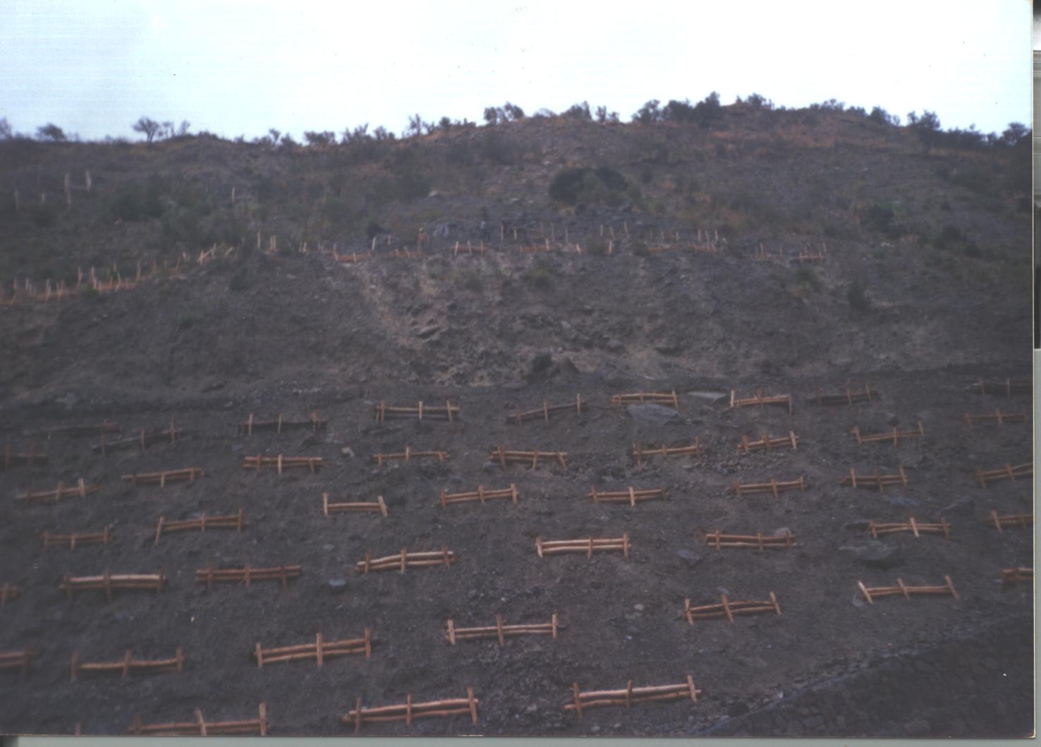
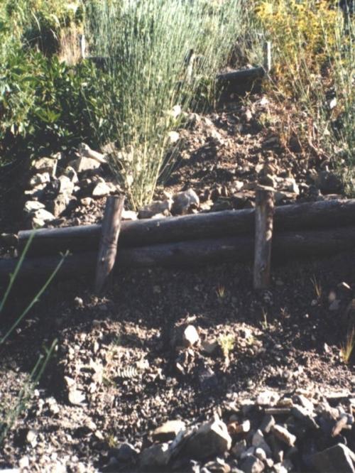
These practices are complemented by SWC measures throughout the catchment: biotrampas are staggered sediment traps located on the steep lateral slopes. They comprise ditches behind wooden barriers where soil accumulates. Biotrampas create suitable sites for tree/bush planting while stabilising the hillsides, reducing erosion, increasing infiltration and slowing siltation of the check dams in the watercourses. Supporting technologies include fenced-off areas for reforestation of the lateral slopes/upper edge of the gully, and finally large gabion dams at the outlets of the gullies, usually 10-25 m in length, but exceptionally up to 200 m.
After a few years vegetation should have stabilised the system, and effectively replaced the wooden and stone constructions. The various practices enhance each other. Establishment is labour demanding, but other costs are low, as long as the material in question is locally obtainable. Maintenance costs are also low. The technology was implemented over a period of six years, starting in 1996, through the Programa de Manejo Integral de Cuencas (PROMIC).
2.3 รูปภาพของเทคโนโลยี
อัลบั้มสื่อบันทึก
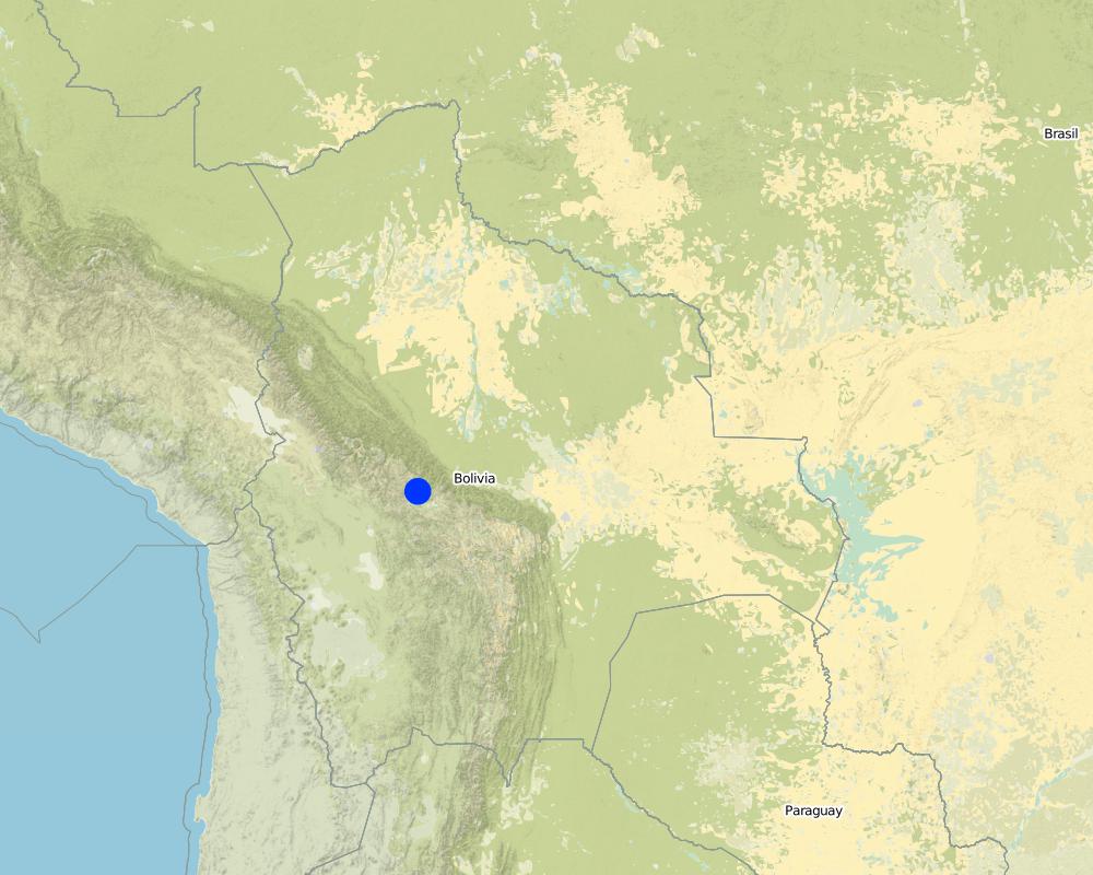
2.5 ประเทศภูมิภาค หรือสถานที่ตั้งที่เทคโนโลยีได้นำไปใช้และได้รับการครอบคลุมโดยการประเมินนี้
ประเทศ:
โบลิเวีย
ภูมิภาค/รัฐ/จังหวัด:
Cochabamba District,
ข้อมูลจำเพาะเพิ่มเติมของสถานที่ตั้ง :
Pajcha Watershed Cordillera del Tunari
ระบุการกระจายตัวของเทคโนโลยี:
- กระจายไปอย่างสม่ำเสมอในพื้นที่
If the Technology is evenly spread over an area, specify area covered (in km2):
6.0
If precise area is not known, indicate approximate area covered:
- 1-10 ตร.กม.
Map
×2.6 วันที่การดำเนินการ
ถ้าไม่รู้ปีที่แน่นอน ให้ระบุวันที่โดยประมาณ:
- 10-50 ปี
2.7 คำแนะนำของเทคโนโลยี
ให้ระบุว่าเทคโนโลยีถูกแนะนำเข้ามาอย่างไร:
- ทางโครงการหรือจากภายนอก
3. การจัดประเภทของเทคโนโลยี SLM
3.1 วัตถุประสงค์หลักของเทคโนโลยี
- ลด ป้องกัน ฟื้นฟู การเสื่อมโทรมของที่ดิน
3.2 ประเภทของการใช้ที่ดินในปัจจุบันที่ได้นำเทคโนโลยีไปใช้

พื้นที่ปลูกพืช
- การปลูกพืชล้มลุกอายุปีเดียว
ระบุ:
Longest growing period in days: 210 Longest growing period from month to month: Oct - Apr

ทุ่งหญ้าเลี้ยงสัตว์
แสดงความคิดเห็น:
Major land use problems (compiler’s opinion): Deforestation, overgrazing and poorly managed channel irrigation in areas with steep slopes: poorly structured soils and
extreme climatic variability causing erosion gullies, landslides, downstream flooding and sedimentation of agricultural land and settlements - including the city of Cochabamba.
Longest growing period in days: 210 Longest growing period from month to month: Oct - Apr
Other grazingland: extensive grazing
3.4 การใช้น้ำ
การใช้น้ำของที่ดินที่มีการใช้เทคโนโลยีอยู่:
- จากน้ำฝน
3.5 กลุ่ม SLM ที่ตรงกับเทคโนโลยีนี้
- มาตรการปลูกพืชขวางความลาดชัน (cross-slope measure)
- การผันน้ำและการระบายน้ำ
- Sediment traps
3.6 มาตรการ SLM ที่ประกอบกันเป็นเทคโนโลยี

มาตรการอนุรักษ์ด้วยวิธีพืช
- V1: ต้นไม้และพุ่มไม้คลุมดิน

มาตรการอนุรักษ์ด้วยโครงสร้าง
- S2: ทำนบ เขื่อนดิน
- S3: Graded ditches, channels, waterways
3.7 รูปแบบหลักของการเสื่อมโทรมของที่ดินที่ได้รับการแก้ไขโดยเทคโนโลยี

การกัดกร่อนของดินโดยน้ำ
- Wg (Gully erosion): การกัดกร่อนแบบร่องธารหรือการทำให้เกิดร่องน้ำเซาะ
- Wm (Mass movement): การเคลื่อนตัวของมวลดินหรือดินถล่ม
- Wo (Offsite degradation): ผลกระทบนอกพื้นที่

การเสื่อมโทรมของดินทางด้านชีวภาพ
- Bq (Quantity/biomass decline): การลดลงของปริมาณหรือมวลชีวภาพ
แสดงความคิดเห็น:
Main type of degradation addressed: Wg: gully erosion / gullying, Wm: mass movements / landslides, Wo: offsite degradation effects, Bq: quantity / biomass decline
3.8 การป้องกัน การลดลง หรือการฟื้นฟูความเสื่อมโทรมของที่ดิน
ระบุเป้าหมายของเทคโนโลยีกับความเสื่อมโทรมของที่ดิน:
- ฟื้นฟูบำบัดที่ดินที่เสื่อมโทรมลงอย่างมาก
4. ข้อมูลจำเพาะด้านเทคนิค กิจกรรมการนำไปปฏิบัติใช้ ปัจจัยนำเข้า และค่าใช้จ่าย
4.1 แบบแปลนทางเทคนิคของเทคโนโลยี
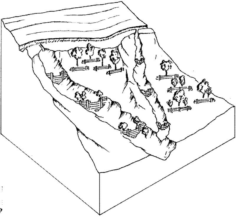
ข้อมูลจำเพาะด้านเทคนิค (แบบแปลนทางเทคนิคของเทคโนโลยี):
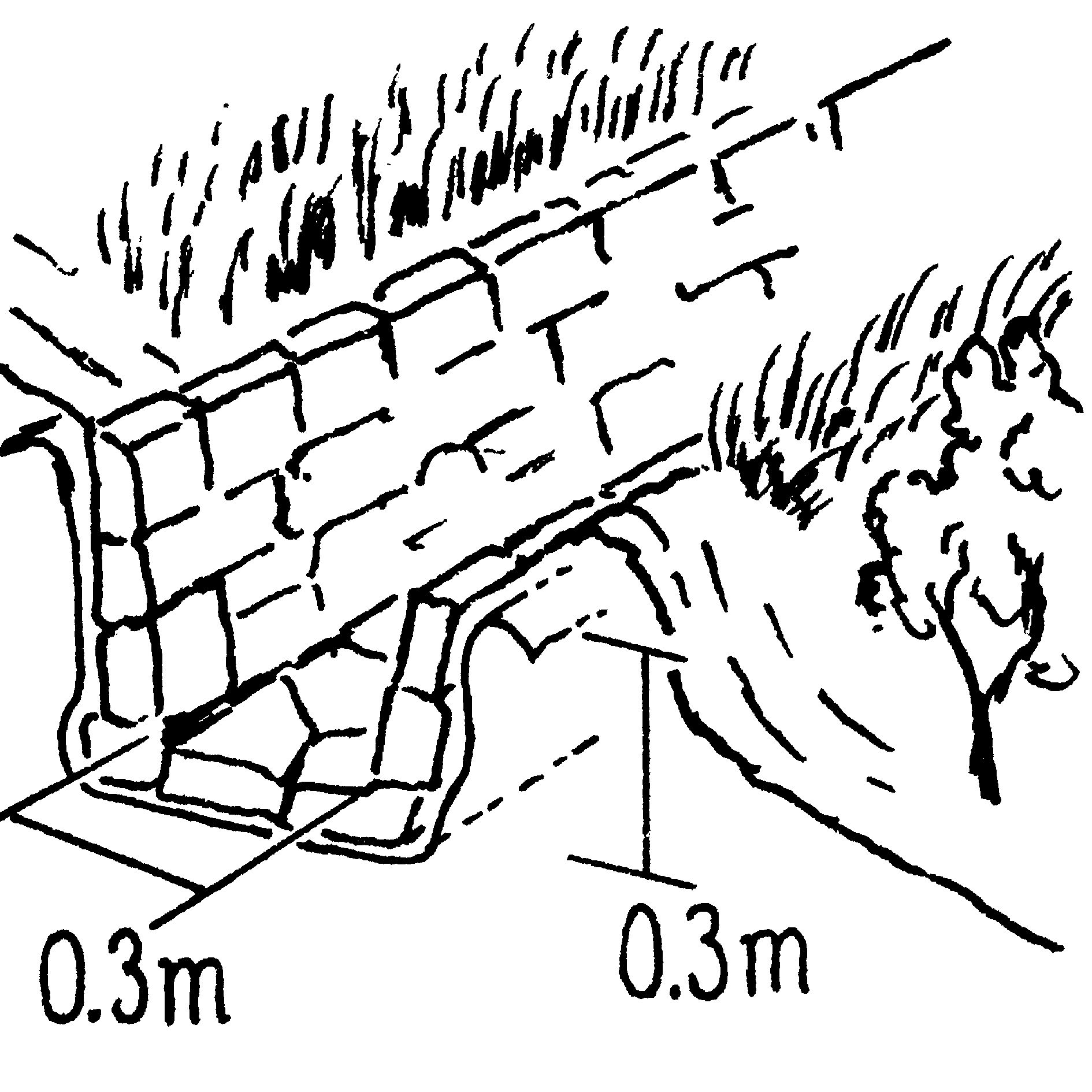
Gully control and catchment protection: an overview of the integrated measures. For details see drawings below.
Vegetative measure: grassed bunds
Vegetative material: G : grass
Structural measure: cut-off drains
Technical knowledge required for field staff / advisors: moderate; Technical knowledge required for land users: moderate
Main technical functions: reduction of slope angle, reduction of slope length, improvement of ground cover, increase in organic matter, sediment retention / trapping, sediment harvesting, control of concentrated runoff; Secondary technical functions: increase of infiltration, control of dispersed runoff
ผู้เขียน:
Mats Gurtner
ข้อมูลจำเพาะด้านเทคนิค (แบบแปลนทางเทคนิคของเทคโนโลยี):
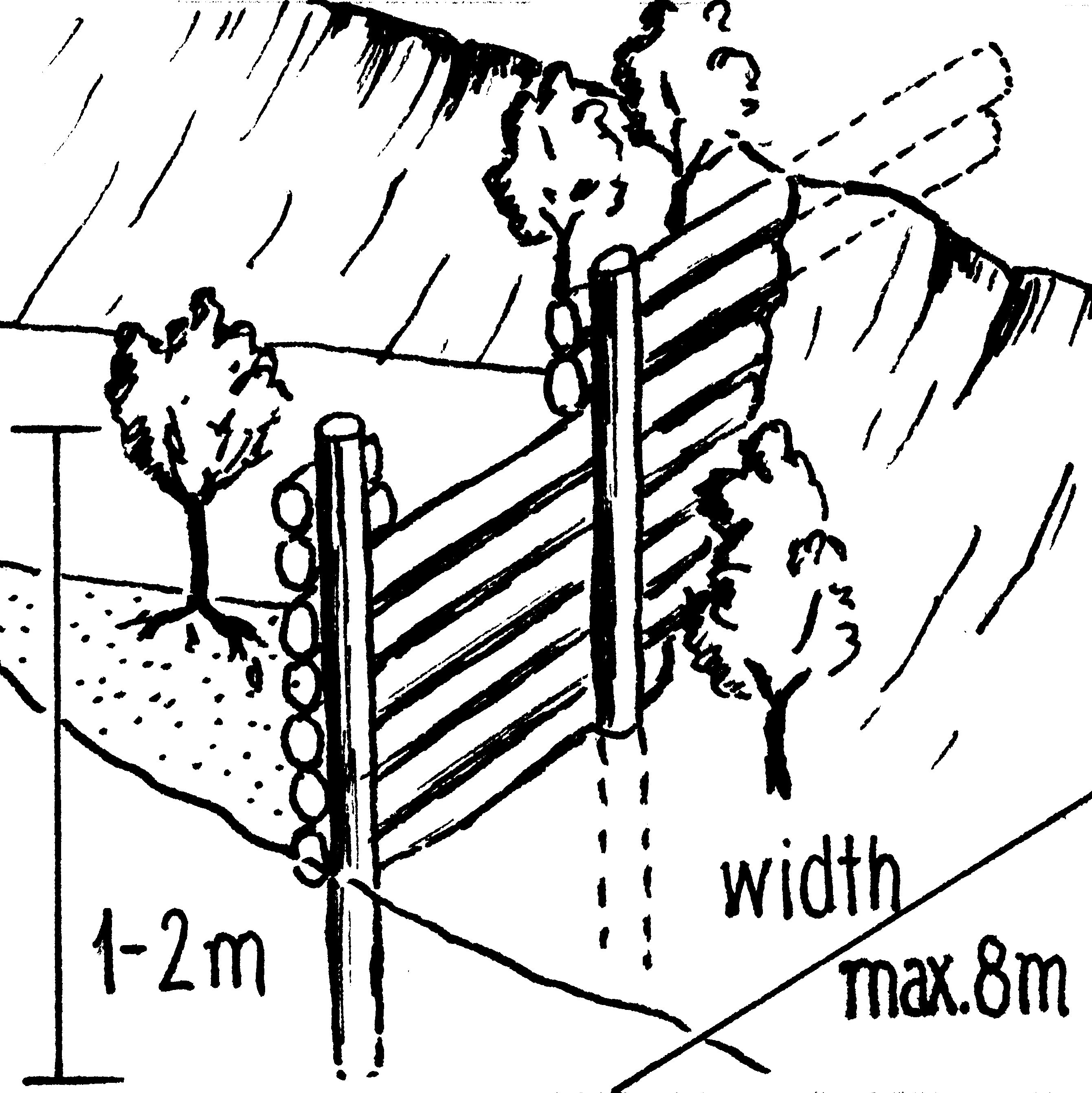
Insert 1: Stone-lined cut-off drain with grass-covered bund and live barriers.
ข้อมูลจำเพาะด้านเทคนิค (แบบแปลนทางเทคนิคของเทคโนโลยี):
Insert 2: Wooden check dam: note that trees are established to further stabilise the gully (as for stone check dams).
ข้อมูลจำเพาะด้านเทคนิค (แบบแปลนทางเทคนิคของเทคโนโลยี):
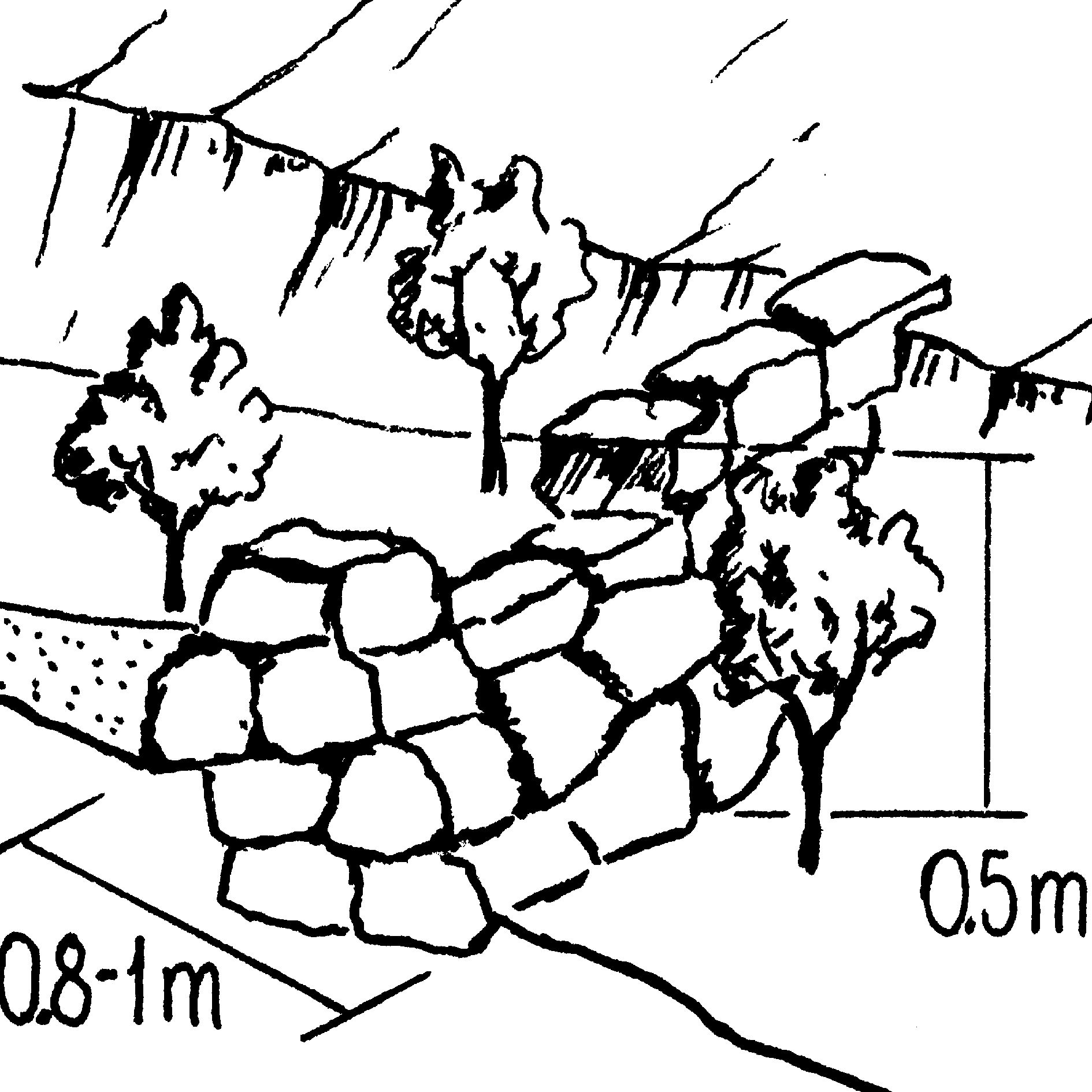
Insert 3: Stone check dam.
ข้อมูลจำเพาะด้านเทคนิค (แบบแปลนทางเทคนิคของเทคโนโลยี):
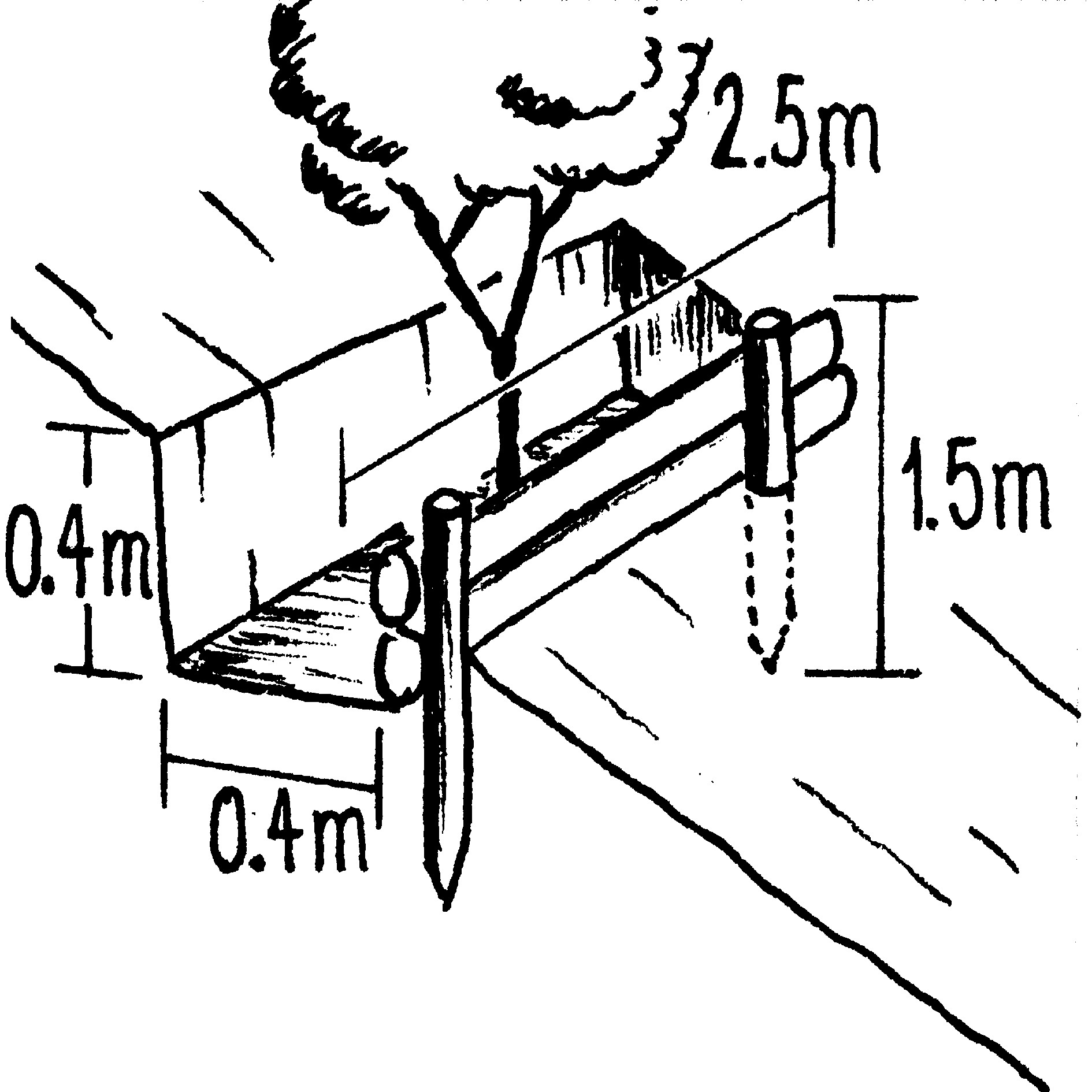
Insert 4: Biotrampa: staggered structures which collect moisture and sediment for tree planting.
4.2 ข้อมูลทั่วไปเกี่ยวกับการคำนวณปัจจัยนำเข้าและค่าใช้จ่าย
ให้ระบุว่าค่าใช้จ่ายและปัจจัยนำเข้าได้รับการคำนวณอย่างไร:
- ต่อพื้นที่ที่ใช้เทคโนโลยี
ระบุสกุลเงินที่ใช้คำนวณค่าใช้จ่าย:
- USD
4.3 กิจกรรมเพื่อการจัดตั้ง
| กิจกรรม | Timing (season) | |
|---|---|---|
| 1. | Plant local bushes and trees in front and behind the biotrampas andthe check dams (after sedimentation). Altitude acclimatisation (2 weeks)is required for the trees before planting. | |
| 2. | Cut-off drains: excavate channel above the gully. Lay stones in the bedand plant local bushes or grass on the bund below the ditch. The outletof the ditch into the gully is stabilised by a few stone steps. | |
| 3. | Stone check dams: excavate a ditch perpendicular to the water channel | during the dry season |
| 4. | Wooden check dams (up to 8 m long, 15–20 cm wide and 1 m high):soil excavation (see 2.). Fix logs with wire or nails to vertical poles.Position a bio-fibre fleece behind the dam to prevent sediment fromflowing through. | |
| 5. | Biotrampas: excavate soil, hammer wooden posts into the soil andfix 2–3 horizontal logs with nails or wire to the wooden posts. | (During dry season) |
| 6. | Plant local bushes and trees in front and behind the biotrampas andthe check dams (after sedimentation). Altitude acclimatisation (2 weeks)is required for the trees before planting. Establish fences to protect the plants. |
4.4 ค่าใช้จ่ายของปัจจัยนำเข้าที่จำเป็นสำหรับการจัดตั้ง
| ปัจจัยนำเข้า | หน่วย | ปริมาณ | ค่าใช้จ่ายต่อหน่วย | ค่าใช้จ่ายทั้งหมดต่อปัจจัยนำเข้า | %ของค่าใช้จ่ายที่ก่อให้เกิดขึ้นโดยผู้ใช้ที่ดิน | |
|---|---|---|---|---|---|---|
| แรงงาน | Labour | ha | 1.0 | 48.0 | 48.0 | |
| อุปกรณ์ | Tools | ha | 1.0 | 4.0 | 4.0 | |
| วัสดุด้านพืช | Seedlings | ha | 1.0 | 19.0 | 19.0 | |
| วัสดุสำหรับก่อสร้าง | Stone | ha | 1.0 | |||
| วัสดุสำหรับก่อสร้าง | Wood | ha | 1.0 | 33.0 | 33.0 | |
| วัสดุสำหรับก่อสร้าง | Nails, wire | ha | 1.0 | 2.0 | 2.0 | |
| วัสดุสำหรับก่อสร้าง | Bio-fibre fleece | ha | 1.0 | 4.0 | 4.0 | |
| ค่าใช้จ่ายทั้งหมดของการจัดตั้งเทคโนโลยี | 110.0 | |||||
| Total costs for establishment of the Technology in USD | 110.0 | |||||
4.5 การบำรุงรักษาสภาพหรือกิจกรรมที่เกิดขึ้นเป็นประจำ
| กิจกรรม | ช่วงระยะเวลา/ความถี่ | |
|---|---|---|
| 1. | Biotrampas: pruning the trees | /every three years. |
| 2. | Cut-off drains: clearing of sediment, cutting bushes and grasses. | |
| 3. | Stone check dams: pruning trees and bushes. After full sedimentation, the dam may be increased in height. | /every three years. |
| 4. | Wooden check dams: pruning trees and bushes | /every three years |
4.6 ค่าใช้จ่ายของปัจจัยนำเข้าและกิจกรรมที่เกิดขึ้นเป็นประจำที่ต้องการการบำรุงรักษา (ต่อปี)
| ปัจจัยนำเข้า | หน่วย | ปริมาณ | ค่าใช้จ่ายต่อหน่วย | ค่าใช้จ่ายทั้งหมดต่อปัจจัยนำเข้า | %ของค่าใช้จ่ายที่ก่อให้เกิดขึ้นโดยผู้ใช้ที่ดิน | |
|---|---|---|---|---|---|---|
| แรงงาน | Labour | ha | 1.0 | 12.0 | 12.0 | 100.0 |
| อุปกรณ์ | Tools | ha | 1.0 | 1.0 | 1.0 | 100.0 |
| วัสดุด้านพืช | Seedlings | ha | 1.0 | 1.0 | 1.0 | 100.0 |
| วัสดุสำหรับก่อสร้าง | Stone | ha | 1.0 | |||
| วัสดุสำหรับก่อสร้าง | Wood | ha | 1.0 | 1.0 | 1.0 | 100.0 |
| วัสดุสำหรับก่อสร้าง | Nails, wire | ha | 1.0 | 1.0 | 1.0 | 100.0 |
| ค่าใช้จ่ายทั้งหมดของการบำรุงรักษาสภาพเทคโนโลยี | 16.0 | |||||
| Total costs for maintenance of the Technology in USD | 16.0 | |||||
แสดงความคิดเห็น:
Costs have been calculated for the whole catchment (6 km2) – including 100 m of cut-off drains, 6,750 m of stone
check dams, 1,500 m of wooden check dams and 770 biotrampas – and then divided by the number of hectares. Wood is not locally available (because of national park laws) and needs to be brought into the area. Establishment and maintenance costs were paid by PROMIC during their intervention period of 6 years. The (high) costs of the gabion weirs further downstream are not included as these are not always required and vary considerably in size from site to site.
5. สิ่งแวดล้อมทางธรรมชาติและของมนุษย์
5.1 ภูมิอากาศ
ฝนประจำปี
- < 250 ม.ม.
- 251-500 ม.ม.
- 501-750 ม.ม.
- 751-1,000 ม.ม.
- 1,001-1,500 ม.ม.
- 1,501-2,000 ม.ม.
- 2,001-3,000 ม.ม.
- 3,001-4,000 ม.ม.
- > 4,000 ม.ม.
เขตภูมิอากาศเกษตร
- กึ่งชุ่มชื้น
- กึ่งแห้งแล้ง
5.2 สภาพภูมิประเทศ
ค่าเฉลี่ยความลาดชัน:
- ราบเรียบ (0-2%)
- ลาดที่ไม่ชัน (3-5%)
- ปานกลาง (6-10%)
- เป็นลูกคลื่น (11-15%)
- เป็นเนิน (16-30%)
- ชัน (31-60%)
- ชันมาก (>60%)
ธรณีสัณฐาน:
- ที่ราบสูง/ที่ราบ
- สันเขา
- ไหล่เขา
- ไหล่เนินเขา
- ตีนเนิน
- หุบเขา
ระดับความสูง:
- 0-100 เมตร
- 101-500 เมตร
- 501-1,000 เมตร
- 1,001-1,500 เมตร
- 1,501-2,000 เมตร
- 2,001-2,500 เมตร
- 2,501-3,000 เมตร
- 3,001-4,000 เมตร
- > 4,000 เมตร
ความคิดเห็นและข้อมูลจำเพาะเพิ่มเติมเรื่องสภาพภูมิประเทศ:
Slopes on average: Also very steep and hilly (both ranked 2) and moderate and rolling (both ranked 3)
5.3 ดิน
ค่าเฉลี่ยความลึกของดิน:
- ตื้นมาก (0-20 ซ.ม.)
- ตื้น (21-50 ซ.ม.)
- ลึกปานกลาง (51-80 ซ.ม.)
- ลึก (81-120 ซ.ม.)
- ลึกมาก (>120 ซ.ม.)
เนื้อดิน (ดินชั้นบน):
- ปานกลาง (ดินร่วน ทรายแป้ง)
อินทรียวัตถุในดิน:
- สูง (>3%)
- ต่ำ (<1%)
(ถ้ามี) ให้แนบคำอธิบายเรื่องดินแบบเต็มหรือระบุข้อมูลที่มีอยู่ เช่น ชนิดของดิน ค่า pH ของดินหรือความเป็นกรดของดิน ความสามารถในการแลกเปลี่ยนประจุบวก ไนโตรเจน ความเค็ม เป็นต้น:
Soil depth on average: Also Very shallow (ranked 2) and shallow as well as deep (both ranked 3)
Soil fertility: Low and very low
Topsoil organic matter: High (on the cropland at high altitudes) and low (in the gullies)
Soil drainage/infiltration: Medium
5.6 ลักษณะของผู้ใช้ที่ดินที่นำเทคโนโลยีไปปฏิบัติใช้
แนวทางการตลาดของระบบการผลิต:
- เพื่อการยังชีพ (หาเลี้ยงตนเอง)
รายได้ที่มาจากนอกฟาร์ม:
- 10-50% ของรายได้ทั้งหมด
ระบุลักษณะอื่นๆที่เกี่ยวข้องของผู้ใช้ที่ดิน:
Market orientation: Subsistence (mostly subsistence (self-supply) with low market income)
5.7 Average area of land used by land users applying the Technology
- < 0.5 เฮกตาร์
- 0.5-1 เฮกตาร์
- 1-2 เฮกตาร์
- 2-5 เฮกตาร์
- 5-15 เฮกตาร์
- 15-50 เฮกตาร์
- 50-100 เฮกตาร์
- 100-500 เฮกตาร์
- 500-1,000 เฮกตาร์
- 1,000-10,000 เฮกตาร์
- >10,000 เฮกตาร์
5.8 กรรมสิทธิ์ในที่ดิน สิทธิในการใช้ที่ดินและสิทธิในการใช้น้ำ
กรรมสิทธิ์ในที่ดิน:
- รายบุคคล ได้รับสิทธิครอบครอง
- communal grassland
สิทธิในการใช้ที่ดิน:
- เกี่ยวกับชุมชน (ถูกจัดระเบียบ)
- รายบุคคล
6. ผลกระทบและสรุปคำบอกกล่าว
6.1 ผลกระทบในพื้นที่ดำเนินการ (On-site) จากการใช้เทคโนโลยี
ผลกระทบทางด้านเศรษฐกิจและสังคม
การผลิต
การผลิตพืชผล
แสดงความคิดเห็น/ระบุ:
Maintained: Due to prevention of further land loss
การผลิตพืชที่ใช้เลี้ยงปศุสัตว์
แสดงความคิดเห็น/ระบุ:
Maintained: Due to prevention of further land loss
รายได้และค่าใช้จ่าย
ภาระงาน
แสดงความคิดเห็น/ระบุ:
High labour input for establishment (though paid in this instance)
ผลกระทบด้านสังคมวัฒนธรรมอื่น ๆ
สถาบันของชุมชน
SLM หรือความรู้เรื่องความเสื่อมโทรมของที่ดิน
ผลกระทบด้านนิเวศวิทยา
ดิน
ความชื้นในดิน
สิ่งปกคลุมดิน
การสูญเสียดิน
6.2 ผลกระทบนอกพื้นที่ดำเนินการ (Off-site) จากการใช้เทคโนโลยี
น้ำท่วมพื้นที่ท้ายน้ำ
การทับถมของดินตะกอนพื้นที่ท้ายน้ำ
Benefit not for implementing farmers
แสดงความคิดเห็น/ระบุ:
farmers implementing SWC are not those benefiting most from the impact in the short term
6.4 การวิเคราะห์ค่าใช้จ่ายและผลประโยชน์ที่ได้รับ
ผลประโยชน์ที่ได้รับเปรียบเทียบกับค่าใช้จ่ายในการจัดตั้งเป็นอย่างไร (จากมุมมองของผู้ใช้ที่ดิน)
ผลตอบแทนระยะสั้น:
ด้านบวกอย่างมาก
ผลตอบแทนระยะยาว:
ด้านบวกอย่างมาก
ผลประโยชน์ที่ได้รับเปรียบเทียบกับค่าใช้จ่ายในการบำรุงรักษาหรือต้นทุนที่เกิดขึ้นซ้ำอีก เป็นอย่างไร (จากมุมมองของผู้ใช้ที่ดิน)
ผลตอบแทนระยะสั้น:
ด้านบวกอย่างมาก
ผลตอบแทนระยะยาว:
ด้านบวกอย่างมาก
6.5 การปรับตัวของเทคโนโลยี
Of all those who have adopted the Technology, how many did so spontaneously, i.e. without receiving any material incentives/ payments?
- 0-10%
แสดงความคิดเห็น:
100% of land user families have adopted the Technology with external material support
There is no trend towards spontaneous adoption of the Technology
Comments on adoption trend: Only a few farmers have built new structures post-project. This is due to different reasons: (1) PROMIC stopped its financial support; (2) the gullied areas are not used by farmers, therefore they have little reason to protect them; (3) the catchment is w
6.7 จุดแข็ง / ข้อได้เปรียบ / โอกาสของเทคโนโลยี
| จุดแข็ง / ข้อได้เปรียบ / โอกาสในทัศนคติของผู้รวบรวมหรือวิทยากรหลัก |
|---|
|
Reduction of landslips and flooding in the valley How can they be sustained / enhanced? New small gullies may originate inside an existing gully or around it. It is important to continue to maintain the current measures and construct new, even though the subsidies of PROMIC have been terminated. |
|
The technology could be implemented by the farmers themselves as materials (except for wood) and tools are locally available How can they be sustained / enhanced? Prolong the sensitisation work to convince the farmers of the necessity and benefits of the technology. |
|
Reduction of soil loss in the watershed How can they be sustained / enhanced? Do not apply the mentioned practices in isolation but always in combination. |
| Simple technology with high positive long-term impact, especially downstream. |
6.8 จุดอ่อน / ข้อเสียเปรียบ / ความเสี่ยงของเทคโนโลยีและวิธีการแก้ไข
| จุดอ่อน / ข้อเสียเปรียบ / ความเสี่ยงในทัศนคติของผู้รวบรวมหรือวิทยากรหลัก | มีวิธีการแก้ไขได้อย่างไร |
|---|---|
| The technology doesn’t address the root cause of human induced gully erosion | Alongside the gully control technology it is necessary to apply complementary conservation measures on the cropland above the gully to prevent new gully development. |
| High labour input for establishment of SWC measures. | An agreement on sustainable use of trees should be made with the national park authority. |
| The technology partly depends on inputs that are not available locally: timber for establishment of wooden structures (which is a significant quantity) are brought in from outside (since the area is within a national park tree felling is not allowed) |
7. การอ้างอิงและการเชื่อมต่อ
7.1 วิธีการและแหล่งข้อมูล
7.2 การอ้างอิงถึงสิ่งตีพิมพ์
หัวข้อ, ผู้เขียน, ปี, หมายเลข ISBN:
Documentation of PROMIC (see address above)
ชื่อเรื่อง ผู้เขียน ปี ISBN:
PROMIC, Programa de Manejo Integral
de Cuencas, Av. Atahuallpa final, Parque Tunari, casilla 4909, Cochabamba, Bolivia; promic@promic-bolivia.org; www.promic-bolivia.org
ลิงก์และโมดูล
ขยายทั้งหมด ย่อทั้งหมดลิงก์
Incentive-based catchment treatment [โบลิเวีย]
A project supported, incentive-based approach: farmers are sensitised about erosion, and involved in gully control and other measures to protect catchments.
- ผู้รวบรวม: Unknown User
โมดูล
ไม่มีโมดูล