traditional cut-off drain [เอธิโอเปีย]
- ผู้สร้างสรรค์:
- การอัพเดท:
- ผู้รวบรวม: Sabina Erny
- ผู้เรียบเรียง: –
- ผู้ตรวจสอบ: Fabian Ottiger, Alexandra Gavilano
boy (amharic), traditional ditch
technologies_1467 - เอธิโอเปีย
ดูส่วนย่อย
ขยายทั้งหมด ย่อทั้งหมด1. ข้อมูลทั่วไป
1.2 รายละเอียดที่ติดต่อได้ของผู้รวบรวมและองค์กรที่เกี่ยวข้องในการประเมินและการจัดเตรียมทำเอกสารของเทคโนโลยี
ชื่อขององค์กรซึ่งอำนวยความสะดวกในการทำเอกสารหรือการประเมินเทคโนโลยี (ถ้าเกี่ยวข้อง)
Department of Geography, University of Basel (Department of Geography, University of Basel) - สวิตเซอร์แลนด์1.3 เงื่อนไขการใช้ข้อมูลที่ได้บันทึกผ่านทาง WOCAT
ผู้รวบรวมและวิทยากรหลักยอมรับเงื่อนไขเกี่ยวกับการใช้ข้อมูลที่ถูกบันทึกผ่านทาง WOCAT:
ใช่
2. การอธิบายลักษณะของเทคโนโลยี SLM
2.1 การอธิบายแบบสั้น ๆ ของเทคโนโลยี
คำจำกัดความของเทคโนโลยี:
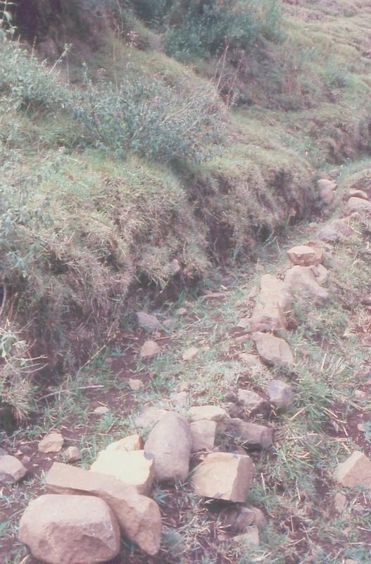
graded ditch out of soil and stones to protect the fields below from water runoff
2.2 การอธิบายแบบละเอียดของเทคโนโลยี
คำอธิบาย:
The ditch is digged into the steep land, into the soil. The lowert side is usually layn out with sontes to raise the soil wall and to stabilize the ditch so the water won't break through.
Purpose of the Technology: protect the field below from water runoff
Establishment / maintenance activities and inputs: by farmers on a individual basis, both establishment and maintenance is entirely up to the farmers.
Natural / human environment: steep, cultivated slope
2.3 รูปภาพของเทคโนโลยี
อัลบั้มสื่อบันทึก
2.5 ประเทศภูมิภาค หรือสถานที่ตั้งที่เทคโนโลยีได้นำไปใช้และได้รับการครอบคลุมโดยการประเมินนี้
ประเทศ:
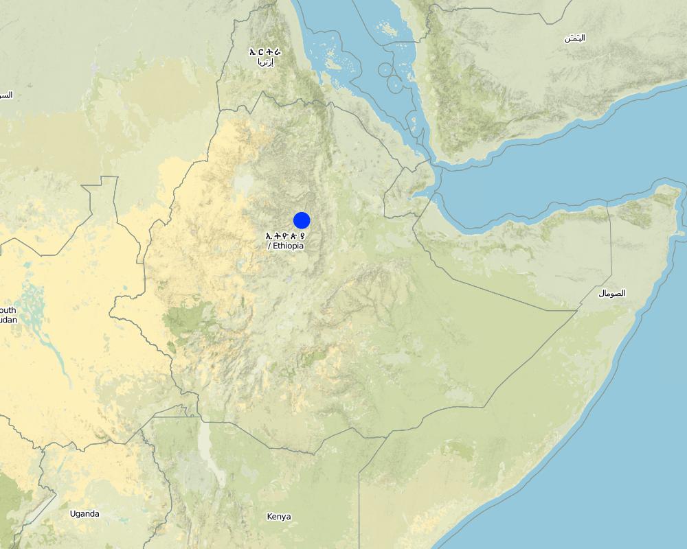
เอธิโอเปีย
ภูมิภาค/รัฐ/จังหวัด:
South Wello
ระบุการกระจายตัวของเทคโนโลยี:
- กระจายไปอย่างสม่ำเสมอในพื้นที่
If precise area is not known, indicate approximate area covered:
- 0.1-1 ตร.กม.
Map
×2.6 วันที่การดำเนินการ
ถ้าไม่รู้ปีที่แน่นอน ให้ระบุวันที่โดยประมาณ:
- มากกว่า 50 ปี (แบบดั้งเดิม)
2.7 คำแนะนำของเทคโนโลยี
ให้ระบุว่าเทคโนโลยีถูกแนะนำเข้ามาอย่างไร:
- เป็นส่วนหนึ่งของระบบแบบดั้งเดิมที่ทำก้นอยู่ (> 50 ปี)
ความคิดเห็น (ประเภทของโครงการ เป็นต้น) :
it is local, indigenous
3. การจัดประเภทของเทคโนโลยี SLM
3.1 วัตถุประสงค์หลักของเทคโนโลยี
- ป้องกันพื้นที่ลุ่มน้ำ/บริเวณท้ายน้ำ โดยร่วมกับเทคโนโลยีอื่นๆ
3.2 ประเภทของการใช้ที่ดินในปัจจุบันที่ได้นำเทคโนโลยีไปใช้

พื้นที่ปลูกพืช
- การปลูกพืชล้มลุกอายุปีเดียว
Annual cropping - Specify crops:
- cereals - barley
- cereals - maize
- cereals - wheat (spring)
- legumes and pulses - beans
- emmer wheat, teff
จำนวนของฤดูเพาะปลูกต่อปี:
- 2
ระบุ:
Longest growing period in days: 150 Longest growing period from month to month: Jul - Nov Second longest growing period in days: 150 Second longest growing period from month to month: Jan - May
แสดงความคิดเห็น:
Major land use problems (compiler’s opinion): erosion, decline of soil fertility and yield decline
other major SWC specialist: shortage of grazing land and of forage
Major land use problems (land users’ perception): erosion, runoff, drought, climate
Type of cropping system and major crops comments: barley/wheat/emmer wheat - beans or teff - maize - barley/wheat/emmer wheat - beans or teff - maize
3.4 การใช้น้ำ
การใช้น้ำของที่ดินที่มีการใช้เทคโนโลยีอยู่:
- จากน้ำฝน
3.5 กลุ่ม SLM ที่ตรงกับเทคโนโลยีนี้
- มาตรการปลูกพืชขวางความลาดชัน (cross-slope measure)
3.6 มาตรการ SLM ที่ประกอบกันเป็นเทคโนโลยี

มาตรการอนุรักษ์ด้วยโครงสร้าง
- S3: Graded ditches, channels, waterways
แสดงความคิดเห็น:
Main measures: structural measures
3.7 รูปแบบหลักของการเสื่อมโทรมของที่ดินที่ได้รับการแก้ไขโดยเทคโนโลยี

การกัดกร่อนของดินโดยน้ำ
- Wt (Loss of topsoil): การสูญเสียดินชั้นบนหรือการกัดกร่อนที่ผิวดิน
แสดงความคิดเห็น:
Main type of degradation addressed: Wt: loss of topsoil / surface erosion
4. ข้อมูลจำเพาะด้านเทคนิค กิจกรรมการนำไปปฏิบัติใช้ ปัจจัยนำเข้า และค่าใช้จ่าย
4.1 แบบแปลนทางเทคนิคของเทคโนโลยี
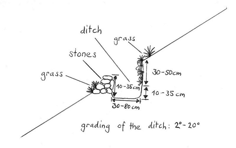
ข้อมูลจำเพาะด้านเทคนิค (แบบแปลนทางเทคนิคของเทคโนโลยี):
drawing showing a traditional ditch, Maybar, Ethiopia
Location: Maybar. Wello
Technical knowledge required for field staff / advisors: moderate
Technical knowledge required for land users: low
Main technical functions: control of dispersed runoff: retain / trap, control of dispersed runoff: impede / retard
Construction material (earth): the ditch is digged out and the earth is the used to build the walls a little bit higher and ist is
Construction material (stone): to lay out the earth wall on the lower side
Slope (which determines the spacing indicated above): 50%
Lateral gradient along the structure: 25%
ผู้เขียน:
Sabina Erny, Basel, Switzerland
4.3 กิจกรรมเพื่อการจัดตั้ง
| กิจกรรม | Timing (season) | |
|---|---|---|
| 1. | it grows itself | |
| 2. | dig out the ditch | |
| 3. | lay out the ditch with stones |
4.5 การบำรุงรักษาสภาพหรือกิจกรรมที่เกิดขึ้นเป็นประจำ
| กิจกรรม | ช่วงระยะเวลา/ความถี่ | |
|---|---|---|
| 1. | clean the ditch from sediments | best before rain season/whenever needed, necessary |
| 2. | add new stones, maybe fix holes | best before rain season/wheneever needed, necessar |
4.6 ค่าใช้จ่ายของปัจจัยนำเข้าและกิจกรรมที่เกิดขึ้นเป็นประจำที่ต้องการการบำรุงรักษา (ต่อปี)
แสดงความคิดเห็น:
the farmers do this themselves, it is part of their annual work
4.7 ปัจจัยสำคัญที่สุดที่มีผลกระทบต่อค่าใช้จ่าย
ปัจจัยสำคัญที่สุดที่มีผลกระทบต่อค่าใช้จ่ายต่างๆ:
soil depth and soil type affects the time it takes to dig out the ditch
5. สิ่งแวดล้อมทางธรรมชาติและของมนุษย์
5.1 ภูมิอากาศ
ฝนประจำปี
- < 250 ม.ม.
- 251-500 ม.ม.
- 501-750 ม.ม.
- 751-1,000 ม.ม.
- 1,001-1,500 ม.ม.
- 1,501-2,000 ม.ม.
- 2,001-3,000 ม.ม.
- 3,001-4,000 ม.ม.
- > 4,000 ม.ม.
ระบุปริมาณน้ำฝนเฉลี่ยรายปี (ถ้ารู้) :หน่วย ม.ม.
1067.00
เขตภูมิอากาศเกษตร
- กึ่งชุ่มชื้น
Moist dega
5.2 สภาพภูมิประเทศ
ค่าเฉลี่ยความลาดชัน:
- ราบเรียบ (0-2%)
- ลาดที่ไม่ชัน (3-5%)
- ปานกลาง (6-10%)
- เป็นลูกคลื่น (11-15%)
- เป็นเนิน (16-30%)
- ชัน (31-60%)
- ชันมาก (>60%)
ธรณีสัณฐาน:
- ที่ราบสูง/ที่ราบ
- สันเขา
- ไหล่เขา
- ไหล่เนินเขา
- ตีนเนิน
- หุบเขา
ระดับความสูง:
- 0-100 เมตร
- 101-500 เมตร
- 501-1,000 เมตร
- 1,001-1,500 เมตร
- 1,501-2,000 เมตร
- 2,001-2,500 เมตร
- 2,501-3,000 เมตร
- 3,001-4,000 เมตร
- > 4,000 เมตร
ความคิดเห็นและข้อมูลจำเพาะเพิ่มเติมเรื่องสภาพภูมิประเทศ:
Landforms: Hill slopes (quite steep)
5.3 ดิน
ค่าเฉลี่ยความลึกของดิน:
- ตื้นมาก (0-20 ซ.ม.)
- ตื้น (21-50 ซ.ม.)
- ลึกปานกลาง (51-80 ซ.ม.)
- ลึก (81-120 ซ.ม.)
- ลึกมาก (>120 ซ.ม.)
เนื้อดิน (ดินชั้นบน):
- ละเอียด/หนัก (ดินเหนียว)
อินทรียวัตถุในดิน:
- สูง (>3%)
- ปานกลาง (1-3%)
(ถ้ามี) ให้แนบคำอธิบายเรื่องดินแบบเต็มหรือระบุข้อมูลที่มีอยู่ เช่น ชนิดของดิน ค่า pH ของดินหรือความเป็นกรดของดิน ความสามารถในการแลกเปลี่ยนประจุบวก ไนโตรเจน ความเค็ม เป็นต้น:
Soil fertility: Medium (ranked 1) and low (ranked 2)
Soil drainage/infiltration: Medium
Soil water storage capacity: Low (ranked 1) and medium (ranked 2)
5.6 ลักษณะของผู้ใช้ที่ดินที่นำเทคโนโลยีไปปฏิบัติใช้
รายได้ที่มาจากนอกฟาร์ม:
- 10-50% ของรายได้ทั้งหมด
ระดับของความมั่งคั่งโดยเปรียบเทียบ:
- รวย
ระดับของการใช้เครื่องจักรกล:
- งานที่ใช้แรงกาย
- การใช้กำลังจากสัตว์
ระบุลักษณะอื่นๆที่เกี่ยวข้องของผู้ใช้ที่ดิน:
Population density: 100-200 persons/km2
10% of the land users are rich and own 38% of the land (only rough estimates).
58% of the land users are average wealthy and own 36% of the land (only rough estimates).
32% of the land users are poor and own 26% of the land (only rough estimates).
Level of mechanization: Animal traction (ranked 1, ploughing with oxen) and manual work (ranked 2, hacking)
Off-farm income specification: farmers employ others for ploughing, so they can go to the market
5.8 กรรมสิทธิ์ในที่ดิน สิทธิในการใช้ที่ดินและสิทธิในการใช้น้ำ
กรรมสิทธิ์ในที่ดิน:
- รัฐ
- leased, individual
- leased, individual
6. ผลกระทบและสรุปคำบอกกล่าว
6.4 การวิเคราะห์ค่าใช้จ่ายและผลประโยชน์ที่ได้รับ
ผลประโยชน์ที่ได้รับเปรียบเทียบกับค่าใช้จ่ายในการจัดตั้งเป็นอย่างไร (จากมุมมองของผู้ใช้ที่ดิน)
ผลตอบแทนระยะสั้น:
ด้านลบเล็กน้อย
ผลตอบแทนระยะยาว:
ด้านบวก
ผลประโยชน์ที่ได้รับเปรียบเทียบกับค่าใช้จ่ายในการบำรุงรักษาหรือต้นทุนที่เกิดขึ้นซ้ำอีก เป็นอย่างไร (จากมุมมองของผู้ใช้ที่ดิน)
ผลตอบแทนระยะสั้น:
ด้านบวกเล็กน้อย
ผลตอบแทนระยะยาว:
ด้านบวก
6.5 การปรับตัวของเทคโนโลยี
ถ้ามีข้อมูลให้บอกปริมาณด้วย (จำนวนของครัวเรือนหรือครอบคลุมพื้นที่):
200
Of all those who have adopted the Technology, how many did so spontaneously, i.e. without receiving any material incentives/ payments?
- 91-100%
แสดงความคิดเห็น:
Comments on acceptance with external material support: survey results
100% of land user families have adopted the Technology without any external material support
200 land user families have adopted the Technology without any external material support
Comments on spontaneous adoption: survey results
There is no trend towards spontaneous adoption of the Technology
Comments on adoption trend: the ditches are the same; the farmers still build them the same way.
7. การอ้างอิงและการเชื่อมต่อ
7.1 วิธีการและแหล่งข้อมูล
7.2 การอ้างอิงถึงสิ่งตีพิมพ์
หัวข้อ, ผู้เขียน, ปี, หมายเลข ISBN:
Biological soil conservation techniques for Maybar area, Ethiopia. Kassaye Goshu. 1997.
ชื่อเรื่อง ผู้เขียน ปี ISBN:
CDE, Bern
หัวข้อ, ผู้เขียน, ปี, หมายเลข ISBN:
Classification of the Environment Conditions. H.-J. Krüger. 2003.
ชื่อเรื่อง ผู้เขียน ปี ISBN:
CDE, Bern
หัวข้อ, ผู้เขียน, ปี, หมายเลข ISBN:
Area of Maybar, Wello, Ethiopia: Long-term Monitoring of the Agricultural Environment 1981-1994
ชื่อเรื่อง ผู้เขียน ปี ISBN:
CDE, Bern
หัวข้อ, ผู้เขียน, ปี, หมายเลข ISBN:
The Use, Maintenance and Development of Soil and Water Conservation Measures by Small-Scale Farming Householfs in Different Agro-Climatic Zones of Northern Shewa and Southern Wello, Ethiopia.Yohannes Gebre Michael. 1999.
ชื่อเรื่อง ผู้เขียน ปี ISBN:
CDE, Bern
ลิงก์และโมดูล
ขยายทั้งหมด ย่อทั้งหมดลิงก์
ไม่มีลิงก์
โมดูล
ไม่มีโมดูล