Current wheat crop in rotation with chickpea cultivation [ทาจิกิสถาน]
- ผู้สร้างสรรค์:
- การอัพเดท:
- ผู้รวบรวม: Malgorzata Conder
- ผู้เรียบเรียง: –
- ผู้ตรวจสอบ: Fabian Ottiger, Alexandra Gavilano
technologies_1552 - ทาจิกิสถาน
ดูส่วนย่อย
ขยายทั้งหมด ย่อทั้งหมด1. ข้อมูลทั่วไป
1.2 รายละเอียดที่ติดต่อได้ของผู้รวบรวมและองค์กรที่เกี่ยวข้องในการประเมินและการจัดเตรียมทำเอกสารของเทคโนโลยี
ชื่อของโครงการซึ่งอำนวยความสะดวกในการทำเอกสารหรือการประเมินเทคโนโลยี (ถ้าเกี่ยวข้อง)
Knowledge Management for Integrated Watershed Management and Disaster Risk Reduction (SDC / IWSM)ชื่อขององค์กรซึ่งอำนวยความสะดวกในการทำเอกสารหรือการประเมินเทคโนโลยี (ถ้าเกี่ยวข้อง)
CDE Centre for Development and Environment (CDE Centre for Development and Environment) - สวิตเซอร์แลนด์1.3 เงื่อนไขการใช้ข้อมูลที่ได้บันทึกผ่านทาง WOCAT
วันที่เก็บรวบรวมข้อมูล(ภาคสนาม) :
06/09/2012
ผู้รวบรวมและวิทยากรหลักยอมรับเงื่อนไขเกี่ยวกับการใช้ข้อมูลที่ถูกบันทึกผ่านทาง WOCAT:
ใช่
1.4 การเปิดเผยเรื่องความยั่งยืนของเทคโนโลยีที่ได้อธิบายไว้
เทคโนโลยีที่ได้อธิบายไว้นี้เป็นปัญหาของความเสื่อมโทรมโทรมของที่ดินหรือไม่ จึงไม่ได้รับการยอมรับว่าเป็นเทคโนโลยีเพื่อการจัดการที่ดินอย่างยั่งยืน:
ไม่ใช่
2. การอธิบายลักษณะของเทคโนโลยี SLM
2.1 การอธิบายแบบสั้น ๆ ของเทคโนโลยี
คำจำกัดความของเทคโนโลยี:
Current wheat crop in yearly rotation with chickpea cultivation
2.2 การอธิบายแบบละเอียดของเทคโนโลยี
คำอธิบาย:
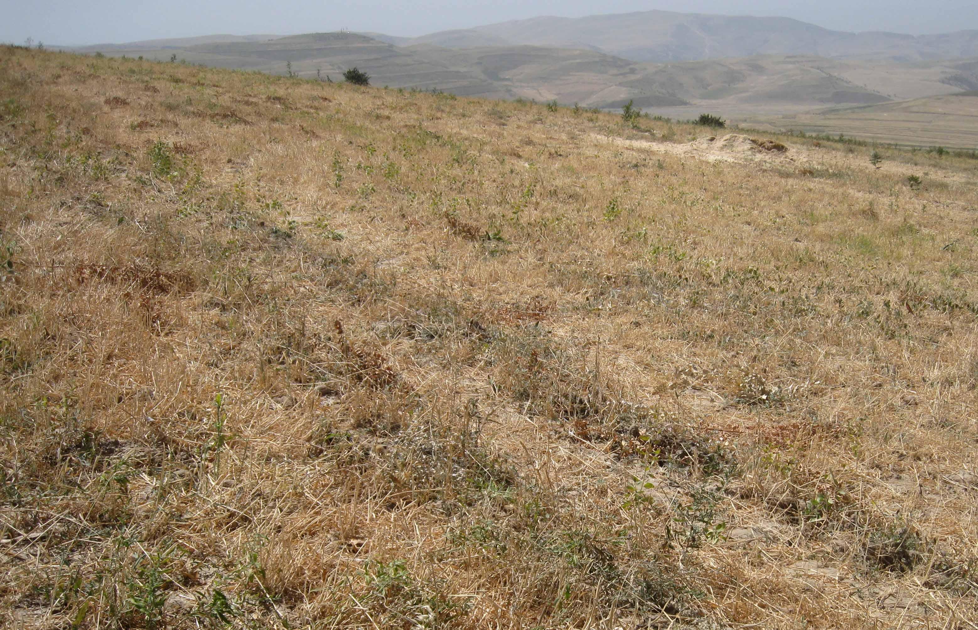
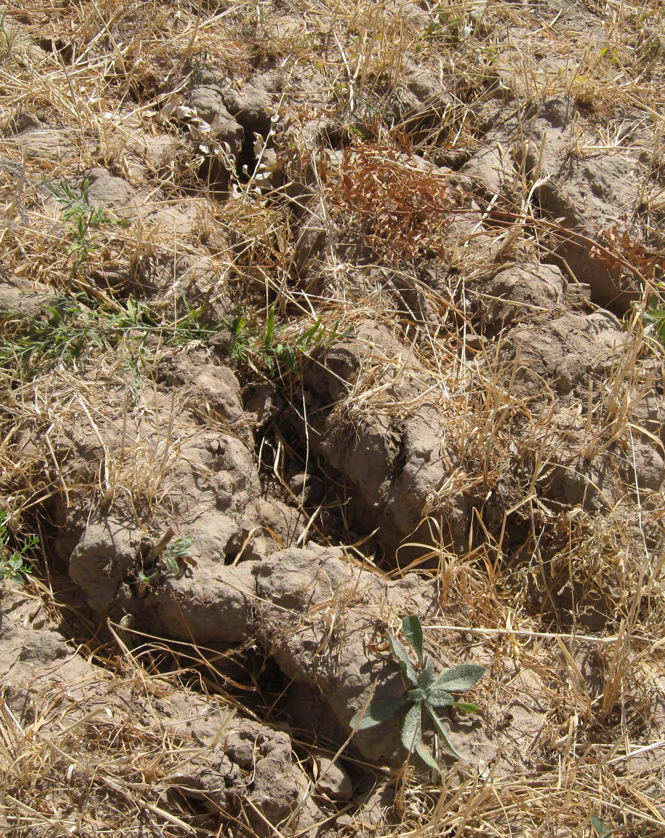
The rainfed crop of the farmer sizes around a hectare. He owns the crop since seven years and switches between chickpea and wheat every year. When he started to cultivate, soil properties were good, he did not use fertilizer. Because of the years of ploughing, the soil lost nutrients and moisture. The more rill building and slope instability is severe currently. The plot is over one hectare because it includes a narrow vegetation strip between his and the neighbours crop. The plot, as all the other crops are grazed by livestock, after harvest.
Purpose of the Technology: Chickpea cropping generates a satisfactory yield, whereas wheat production is rather variable and low. Nevertheless the farmer would not change the crop type because the main purpose is to get straw for feeding his cows. The farmer has over three hectares in total. Even though he claims the benefit to be low comparing to the input, he is content as long he can feed his family.
Establishment / maintenance activities and inputs: Ploughing, sowing and then harvesting were part of the establishment phase. The same activities count for maintenance. But as soil is gradually washed away, fertilizing became crucial. The farmer does not control and protect the crop from wild animals and grazing herds.
Natural / human environment: The crop lies on a foot slope not far from the riverbed. Neighbouring cultivations are of the same crop type, chickpea, wheat and food grain. It is less than one kilometre away from the farmers home in Doshmand village. Access to services is rather low, especially in winter, because of the bad condition of the road. Doctor, middle and higher school grades and market are in the village below.
2.3 รูปภาพของเทคโนโลยี
อัลบั้มสื่อบันทึก
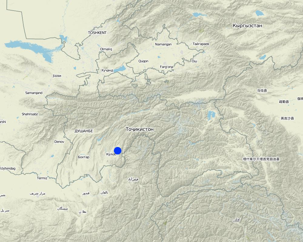
2.5 ประเทศภูมิภาค หรือสถานที่ตั้งที่เทคโนโลยีได้นำไปใช้และได้รับการครอบคลุมโดยการประเมินนี้
ประเทศ:
ทาจิกิสถาน
ภูมิภาค/รัฐ/จังหวัด:
Khatlon, Tajikistan
ข้อมูลจำเพาะเพิ่มเติมของสถานที่ตั้ง :
Muminabad
แสดงความคิดเห็น:
Specify the spread of the Technology:
evenly spread over an area
If the Technology is evenly spread over an area, indicate approximate area covered:
< 0.1 km2 (10 ha)
Comments:
Total area covered by the SLM Technology is 0.01 km2.
Crop counts around 1 ha. Total plot is over 1 ha, because of a narrow vegative strip underneath the crop.
Map
×3. การจัดประเภทของเทคโนโลยี SLM
3.1 วัตถุประสงค์หลักของเทคโนโลยี
- ปรับปรุงการผลิตให้ดีขึ้น
- ลด ป้องกัน ฟื้นฟู การเสื่อมโทรมของที่ดิน
3.2 ประเภทของการใช้ที่ดินในปัจจุบันที่ได้นำเทคโนโลยีไปใช้

พื้นที่ปลูกพืช
- การปลูกพืชล้มลุกอายุปีเดียว
พืชหลัก (พืชเศรษฐกิจและพืชอาหาร):
Major food crop: Wheat
chickpea, wheat and food grain
แสดงความคิดเห็น:
Major land use problems (compiler’s opinion): Sealed and compacted topsoil, which hinders infiltration. Hardpan is propable due to plowing. Erosive processes with rill building are relatively widespread on the crop. A lot of plowing rills aggrandize by runoff. A lot of licorish plant grow on the crop, which is a indicator for degraded soil. Soil shows a low level of organic matter, nutrients and moisture.
Major land use problems (land users’ perception): Increasing soil wash out with simultaneos augmentation of fertilizer input over years. Rills destroy crop growth, reason why yield quantity and quality is decreasing.
Type of cropping system and major crops comments: Farmer doesn't try hard to get a better yield. As long as he can feed his family he doesn't see the real need to do that.
Livestock is grazing on crop residues
3.3 ข้อมูลเพิ่มเติมเกี่ยวกับการใช้ที่ดิน
การใช้น้ำของที่ดินที่มีการใช้เทคโนโลยีอยู่:
- จากน้ำฝน
จำนวนของฤดูเพาะปลูกต่อปี:
- 1
ระบุ:
Longest growing period in days: 180 Longest growing period from month to month: March to September
3.4 กลุ่ม SLM ที่ตรงกับเทคโนโลยีนี้
- ระบบหมุนเวียน (การปลูกพืชหมุนเวียน การพักดิน การเกษตรแบบไร่เลื่อนลอย)
3.5 กระจายตัวของเทคโนโลยี
ระบุการกระจายตัวของเทคโนโลยี:
- กระจายไปอย่างสม่ำเสมอในพื้นที่
ถ้าหากว่าเทคโนโลยีได้มีการกระจายออกไปอย่างสม่ำเสมอในพื้นที่ ให้ระบุปริมาณพื้นที่ที่ได้รับการครอบคลุมถึง:
- < 0.1 ตร.กม.(10 เฮกตาร์)
แสดงความคิดเห็น:
Total area covered by the SLM Technology is 0.01 km2.
Crop counts around 1 ha. Total plot is over 1 ha, because of a narrow vegative strip underneath the crop.
3.7 รูปแบบหลักของการเสื่อมโทรมของที่ดินที่ได้รับการแก้ไขโดยเทคโนโลยี

การกัดกร่อนของดินโดยน้ำ
- Wt (Loss of topsoil): การสูญเสียดินชั้นบนหรือการกัดกร่อนที่ผิวดิน
- Wg (Gully erosion): การกัดกร่อนแบบร่องธารหรือการทำให้เกิดร่องน้ำเซาะ

การเสื่อมโทรมของดินทางด้านเคมี
- Cn (Fertility decline): ความอุดมสมบูรณ์และปริมาณอินทรียวัตถุในดินถูกทำให้ลดลงไป (ไม่ได้เกิดจากสาเหตุการกัดกร่อน)

การเสื่อมโทรมของดินทางด้านกายภาพ
- Pk (Slaking and crusting): การอุดตันของช่องว่างในดินหรือรูพรุน

การเสื่อมโทรมของน้ำ
- Hs (Change in quantity of surface water): การเปลี่ยนแปลงปริมาณของน้ำที่ผิวดิน
แสดงความคิดเห็น:
Main type of degradation addressed: Wt: loss of topsoil / surface erosion, Wg: gully erosion / gullying, Cn: fertility decline and reduced organic matter content
Secondary types of degradation addressed: Pk: sealing and crusting, Hs: change in quantity of surface water
Main causes of degradation: soil management, crop management (annual, perennial, tree/shrub), land tenure (For private cropping and communal grazing)
Secondary causes of degradation: overgrazing, disturbance of water cycle (infiltration / runoff), Heavy / extreme rainfall (intensity/amounts)
3.8 การป้องกัน การลดลง หรือการฟื้นฟูความเสื่อมโทรมของที่ดิน
ระบุเป้าหมายของเทคโนโลยีกับความเสื่อมโทรมของที่ดิน:
- ฟื้นฟูบำบัดที่ดินที่เสื่อมโทรมลงอย่างมาก
4. ข้อมูลจำเพาะด้านเทคนิค กิจกรรมการนำไปปฏิบัติใช้ ปัจจัยนำเข้า และค่าใช้จ่าย
4.2 ข้อมูลจำเพาะด้านเทคนิคและการอธิบายแบบแปลนทางเทคนิค
Contour lined plot, with a vegetation strip of < 1m width, between this and the underneath plot. A lot of rills visible.
Location: Doshmand, Chukurak Watershed. Muminabad, Khatlon, Tajikistan
Main technical functions: control of concentrated runoff: drain / divert, improvement of surface structure (crusting, sealing), stabilisation of soil (eg by tree roots against land slides), increase in organic matter, increase of infiltration
Secondary technical functions: control of concentrated runoff: impede / retard, improvement of ground cover, increase of surface roughness, improvement of topsoil structure (compaction), improvement of subsoil structure (hardpan), increase in nutrient availability (supply, recycling,…), increase / maintain water stored in soil
4.3 ข้อมูลทั่วไปเกี่ยวกับการคำนวณปัจจัยนำเข้าและค่าใช้จ่าย
อื่นๆ หรือสกุลเงินประจำชาติ (ระบุ):
Somoni
ระบุอัตราแลกเปลี่ยนจากดอลลาร์สหรัฐเป็นสกุลเงินท้องถิ่น (ถ้าเกี่ยวข้อง) คือ 1 เหรียญสหรัฐ =:
4.83
ระบุค่าเฉลี่ยของค่าจ้างในการจ้างแรงงานต่อวัน:
12.40
4.5 ค่าใช้จ่ายของปัจจัยนำเข้าที่จำเป็นสำหรับการจัดตั้ง
| ปัจจัยนำเข้า | หน่วย | ปริมาณ | ค่าใช้จ่ายต่อหน่วย | ค่าใช้จ่ายทั้งหมดต่อปัจจัยนำเข้า | %ของค่าใช้จ่ายที่ก่อให้เกิดขึ้นโดยผู้ใช้ที่ดิน | |
|---|---|---|---|---|---|---|
| แรงงาน | Sowing | Person days | 0.25 | 12.4 | 3.1 | 100.0 |
| แรงงาน | Applying fertilizer | Person days | 0.25 | 12.4 | 3.1 | 100.0 |
| แรงงาน | Cutting wheat | Person days | 18.0 | 12.422 | 223.6 | 100.0 |
| แรงงาน | Plowing | Person days | 0.4375 | 12.4 | 5.42 | 100.0 |
| อุปกรณ์ | Machine use | Hours | 3.5 | 5.914 | 20.7 | 100.0 |
| อุปกรณ์ | Petrol | Liters | 40.0 | 1.1375 | 45.5 | 100.0 |
| วัสดุด้านพืช | Seeds | 150.0 | 0.414 | 62.1 | ||
| ปุ๋ยและสารฆ่า/ยับยั้งการเจริญเติบโตของสิ่งมีชีวิต (ไบโอไซด์) | Fertilizer | Bucks | 2.0 | 31.05 | 62.1 | 100.0 |
| ค่าใช้จ่ายทั้งหมดของการจัดตั้งเทคโนโลยี | 425.62 | |||||
แสดงความคิดเห็น:
Duration of establishment phase: 0.125 month(s)
4.6 การบำรุงรักษาสภาพหรือกิจกรรมที่เกิดขึ้นเป็นประจำ
| กิจกรรม | ประเภทของมาตรการ | ช่วงระยะเวลา/ความถี่ | |
|---|---|---|---|
| 1. | Plowing, 3.5 hours, 1 person | จัดการพืช | every year, spring |
| 2. | Sowing wheat, 1 hour, 2 persons | จัดการพืช | every year, spring |
| 3. | Applying fertilizer (not in the first year), 1 hour, 2 persons | จัดการพืช | only once a year in spring, more year by year |
| 4. | Cutting wheat, 6 days (à 8 hours), 3 persons | จัดการพืช | once a year, around semptember |
4.8 ปัจจัยสำคัญที่สุดที่มีผลกระทบต่อค่าใช้จ่าย
ปัจจัยสำคัญที่สุดที่มีผลกระทบต่อค่าใช้จ่ายต่างๆ:
Establishment and maintenance cost are similar. Agricultural inputs as seeds and fertilizer are the highest expenditures. As soil nutrients are washed out, the fertilizer input rises gradually.
5. สิ่งแวดล้อมทางธรรมชาติและของมนุษย์
5.1 ภูมิอากาศ
ฝนประจำปี
- < 250 ม.ม.
- 251-500 ม.ม.
- 501-750 ม.ม.
- 751-1,000 ม.ม.
- 1,001-1,500 ม.ม.
- 1,501-2,000 ม.ม.
- 2,001-3,000 ม.ม.
- 3,001-4,000 ม.ม.
- > 4,000 ม.ม.
ข้อมูลจำเพาะ/ความคิดเห็นเรื่องปริมาณน้ำฝน:
Totally 800 mm: 700mm in winter-spring, July-Sept dry season
เขตภูมิอากาศเกษตร
- กึ่งชุ่มชื้น
Thermal climate class: temperate, LPG from end of March until September
5.2 สภาพภูมิประเทศ
ค่าเฉลี่ยความลาดชัน:
- ราบเรียบ (0-2%)
- ลาดที่ไม่ชัน (3-5%)
- ปานกลาง (6-10%)
- เป็นลูกคลื่น (11-15%)
- เป็นเนิน (16-30%)
- ชัน (31-60%)
- ชันมาก (>60%)
ธรณีสัณฐาน:
- ที่ราบสูง/ที่ราบ
- สันเขา
- ไหล่เขา
- ไหล่เนินเขา
- ตีนเนิน
- หุบเขา
ระดับความสูง:
- 0-100 เมตร
- 101-500 เมตร
- 501-1,000 เมตร
- 1,001-1,500 เมตร
- 1,501-2,000 เมตร
- 2,001-2,500 เมตร
- 2,501-3,000 เมตร
- 3,001-4,000 เมตร
- > 4,000 เมตร
ความคิดเห็นและข้อมูลจำเพาะเพิ่มเติมเรื่องสภาพภูมิประเทศ:
Altitudinal zone: 1501-2000 m a.s.l. (1600 m asl)
5.3 ดิน
ค่าเฉลี่ยความลึกของดิน:
- ตื้นมาก (0-20 ซ.ม.)
- ตื้น (21-50 ซ.ม.)
- ลึกปานกลาง (51-80 ซ.ม.)
- ลึก (81-120 ซ.ม.)
- ลึกมาก (>120 ซ.ม.)
เนื้อดิน (ดินชั้นบน):
- ปานกลาง (ดินร่วน ทรายแป้ง)
- ละเอียด/หนัก (ดินเหนียว)
(ถ้ามี) ให้แนบคำอธิบายเรื่องดินแบบเต็มหรือระบุข้อมูลที่มีอยู่ เช่น ชนิดของดิน ค่า pH ของดินหรือความเป็นกรดของดิน ความสามารถในการแลกเปลี่ยนประจุบวก ไนโตรเจน ความเค็ม เป็นต้น:
Soil fertility: Low
Soil drainage/infiltration: Poor (sealing and probably hard pan)
Soil water storage capacity: Low
5.4 ความเป็นประโยชน์และคุณภาพของน้ำ
คุณภาพน้ำ (ที่ยังไม่ได้บำบัด):
เป็นน้ำใช้เพื่อการเกษตรเท่านั้น (การชลประทาน)
5.5 ความหลากหลายทางชีวภาพ
ความหลากหลายทางชนิดพันธุ์:
- ต่ำ
5.6 ลักษณะของผู้ใช้ที่ดินที่นำเทคโนโลยีไปปฏิบัติใช้
แนวทางการตลาดของระบบการผลิต:
- เพื่อการยังชีพ (หาเลี้ยงตนเอง)
รายได้ที่มาจากนอกฟาร์ม:
- < 10% ของรายได้ทั้งหมด
ระดับของความมั่งคั่งโดยเปรียบเทียบ:
- พอมีพอกิน
เป็นรายบุคคล/ครัวเรือน:
- เป็นรายบุคคล/ครัวเรือน
ระดับของการใช้เครื่องจักรกล:
- งานที่ใช้แรงกาย
- การใช้เครื่องจักรหรือเครื่องยนต์
เพศ:
- ชาย
ระบุลักษณะอื่นๆที่เกี่ยวข้องของผู้ใช้ที่ดิน:
Land users applying the Technology are mainly common / average land users
Population density: 100-200 persons/km2
Annual population growth: 1% - 2%
Off-farm income specification: The farmer has in total over 3 ha of crop. The output of straw of this one hectare makes 40% of his total income.
Level of mechanization: Manual labour (harvesting wheat) and mechanised (plowing)
5.7 พื้นที่เฉลี่ยของที่ดินที่เป็นเจ้าของหรือเช่าโดยผู้ใช้ที่ดินที่นำเทคโนโลยีไปปฏิบัติใช้
- < 0.5 เฮกตาร์
- 0.5-1 เฮกตาร์
- 1-2 เฮกตาร์
- 2-5 เฮกตาร์
- 5-15 เฮกตาร์
- 15-50 เฮกตาร์
- 50-100 เฮกตาร์
- 100-500 เฮกตาร์
- 500-1,000 เฮกตาร์
- 1,000-10,000 เฮกตาร์
- >10,000 เฮกตาร์
พิจารณาว่าเป็นขนาดเล็ก กลาง หรือขนาดใหญ่ (ซึ่งอ้างอิงถึงบริบทระดับท้องถิ่น):
- ขนาดเล็ก
แสดงความคิดเห็น:
2.06 ha (household 7.7 members)
5.8 กรรมสิทธิ์ในที่ดิน สิทธิในการใช้ที่ดินและสิทธิในการใช้น้ำ
กรรมสิทธิ์ในที่ดิน:
- รายบุคคล ได้รับสิทธิครอบครอง
สิทธิในการใช้ที่ดิน:
- เช่า
สิทธิในการใช้น้ำ:
- เกี่ยวกับชุมชน (ถูกจัดระเบียบ)
แสดงความคิดเห็น:
Land ownership is based on the Land user's certificate
5.9 การเข้าถึงบริการและโครงสร้างพื้นฐาน
สุขภาพ:
- จน
- ปานกลาง
- ดี
การศึกษา:
- จน
- ปานกลาง
- ดี
ความช่วยเหลือทางด้านเทคนิค:
- จน
- ปานกลาง
- ดี
การจ้างงาน (เช่น ภายนอกฟาร์ม):
- จน
- ปานกลาง
- ดี
ตลาด:
- จน
- ปานกลาง
- ดี
พลังงาน:
- จน
- ปานกลาง
- ดี
ถนนและการขนส่ง:
- จน
- ปานกลาง
- ดี
น้ำดื่มและการสุขาภิบาล:
- จน
- ปานกลาง
- ดี
บริการด้านการเงิน:
- จน
- ปานกลาง
- ดี
6. ผลกระทบและสรุปคำบอกกล่าว
6.1 ผลกระทบในพื้นที่ดำเนินการ (On-site) จากการใช้เทคโนโลยี
ผลกระทบทางด้านเศรษฐกิจและสังคม
การผลิต
การผลิตพืชผล
การเสี่ยงต่อความล้มเหลวในการผลิต
รายได้และค่าใช้จ่าย
ค่าใช่จ่ายของปัจจัยการผลิตทางการเกษตร
แสดงความคิดเห็น/ระบุ:
demand on fertilizers is increasing
รายได้จากฟาร์ม
แสดงความคิดเห็น/ระบุ:
gradually increasing
ผลกระทบด้านสังคมวัฒนธรรมอื่น ๆ
ความมั่นคงด้านอาหาร / พึ่งตนเองได้
แสดงความคิดเห็น/ระบุ:
Only on long term according to the farmer
ผลกระทบด้านนิเวศวิทยา
วัฐจักรน้ำหรือน้ำบ่า
น้ำไหลบ่าที่ผิวดิน
แสดงความคิดเห็น/ระบุ:
Many rills
ดิน
ความชื้นในดิน
สิ่งปกคลุมดิน
การเกิดแผ่นแข็งที่ผิวดิน /การเกิดชั้นดาน
การอัดแน่นของดิน
อินทรียวัตถุในดิน/ต่ำกว่าดินชั้น C
ลดความเสี่ยงของภัยพิบัติ
ความเร็วของลม
6.2 ผลกระทบนอกพื้นที่ดำเนินการ (Off-site) จากการใช้เทคโนโลยี
น้ำท่วมพื้นที่ท้ายน้ำ
ความสามารถต้านทานการเปลี่ยนแปลง / ความสามารถในการคัดกรอง
6.3 การเผชิญและความตอบสนองของเทคโนโลยีต่อการเปลี่ยนแปลงสภาพภูมิอากาศที่ค่อยเป็นค่อยไป และสภาพรุนแรงของภูมิอากาศ / ภัยพิบัติ (ที่รับรู้ได้โดยผู้ใช้ที่ดิน)
การเปลี่ยนแปลงสภาพภูมิอากาศที่ค่อยเป็นค่อยไป
การเปลี่ยนแปลงสภาพภูมิอากาศที่ค่อยเป็นค่อยไป
| ฤดู | ประเภทของการเปลี่ยนแปลงสภาพภูมิอากาศที่ค่อยเป็นค่อยไป และสภาพรุนแรงของภูมิอากาศ | เทคโนโลยีมีวิธีการรับมืออย่างไร | |
|---|---|---|---|
| อุณหภูมิประจำปี | เพิ่มขึ้น | ไม่ค่อยดี |
สภาพรุนแรงของภูมิอากาศ (ภัยพิบัติ)
ภัยพิบัติทางอุตุนิยมวิทยา
| เทคโนโลยีมีวิธีการรับมืออย่างไร | |
|---|---|
| พายุฝนประจำท้องถิ่น | ไม่ค่อยดี |
| พายุลมประจำท้องถิ่น | ไม่ทราบ |
ภัยพิบัติจากสภาพภูมิอากาศ
| เทคโนโลยีมีวิธีการรับมืออย่างไร | |
|---|---|
| ภัยจากฝนแล้ง | ไม่ค่อยดี |
ภัยพิบัติจากน้ำ
| เทคโนโลยีมีวิธีการรับมืออย่างไร | |
|---|---|
| น้ำท่วมตามปกติ (แม่น้ำ) | ไม่ค่อยดี |
ผลลัพธ์ตามมาที่เกี่ยวข้องกับภูมิอากาศอื่น ๆ
ผลลัพธ์ตามมาที่เกี่ยวข้องกับภูมิอากาศอื่น ๆ
| เทคโนโลยีมีวิธีการรับมืออย่างไร | |
|---|---|
| ช่วงการปลูกพืชที่ลดลงมา | ไม่ทราบ |
แสดงความคิดเห็น:
The crop would be less sensitive to heavy (seasonal) rainfalls or droughts if vegetation cover or mulching would be improved.
6.4 การวิเคราะห์ค่าใช้จ่ายและผลประโยชน์ที่ได้รับ
แสดงความคิดเห็น:
Farmer knows that there is no real benefit when looking at the input. Over the years it got slightly negative because more fertilizer is needed and yield is decreasing.
6.7 จุดแข็ง / ข้อได้เปรียบ / โอกาสของเทคโนโลยี
| จุดแข็ง / ข้อได้เปรียบ / โอกาสในทัศนคติของผู้รวบรวมหรือวิทยากรหลัก |
|---|
|
Vegetation strip underneath the crop is an idea to develop as it reduces the negative offsite effects. How can they be sustained / enhanced? Knowledge transfer about how to reduce offsite effects. Soil cover could rise in that strip, thanks do what soil erosion woul be stopped. Enhance communication between above and below vegetation strip cultivating farmers. |
|
Maintain and develop crop rotation. How can they be sustained / enhanced? Knowledge transfer and field studies on other plots with crop rotation (e.g. perennial crops). |
| Plowing horizontally. |
6.8 จุดอ่อน / ข้อเสียเปรียบ / ความเสี่ยงของเทคโนโลยีและวิธีการแก้ไข
| จุดอ่อน / ข้อเสียเปรียบ / ความเสี่ยงในทัศนคติของผู้รวบรวมหรือวิทยากรหลัก | มีวิธีการแก้ไขได้อย่างไร |
|---|---|
| Too much soil erosion causes rills. | Another crop type according to the steepness of the plot. Change plowing deepness or do human-powered tillage. |
| Development of soil crust, sealing and hardpan. | Enhance crop rotation and "soft" and horizontal tillage practices. |
| Observed trampling and grazing of the plot. | Guarding or fencing of the plot. Guarding could be organized by several farmers in rotation. |
| Poor pecentage of organic matter. | Introduce mulching. |
ลิงก์และโมดูล
ขยายทั้งหมด ย่อทั้งหมดลิงก์
ไม่มีลิงก์
โมดูล
ไม่มีโมดูล