Dams [กาบูเวร์ดี]
- ผู้สร้างสรรค์:
- การอัพเดท:
- ผู้รวบรวม: Jacques Tavares
- ผู้เรียบเรียง: –
- ผู้ตรวจสอบ: Fabian Ottiger, Alexandra Gavilano
Diques de alvenaria
technologies_1571 - กาบูเวร์ดี
ดูส่วนย่อย
ขยายทั้งหมด ย่อทั้งหมด1. ข้อมูลทั่วไป
1.2 รายละเอียดที่ติดต่อได้ของผู้รวบรวมและองค์กรที่เกี่ยวข้องในการประเมินและการจัดเตรียมทำเอกสารของเทคโนโลยี
ผู้เชี่ยวชาญ SLM:
Varela Larissa
INIDA
กาบูเวร์ดี
ชื่อขององค์กรซึ่งอำนวยความสะดวกในการทำเอกสารหรือการประเมินเทคโนโลยี (ถ้าเกี่ยวข้อง)
INIDA (INIDA) - กาบูเวร์ดี1.3 เงื่อนไขการใช้ข้อมูลที่ได้บันทึกผ่านทาง WOCAT
ผู้รวบรวมและวิทยากรหลักยอมรับเงื่อนไขเกี่ยวกับการใช้ข้อมูลที่ถูกบันทึกผ่านทาง WOCAT:
ใช่
1.4 การเปิดเผยเรื่องความยั่งยืนของเทคโนโลยีที่ได้อธิบายไว้
เทคโนโลยีที่ได้อธิบายไว้นี้เป็นปัญหาของความเสื่อมโทรมโทรมของที่ดินหรือไม่ จึงไม่ได้รับการยอมรับว่าเป็นเทคโนโลยีเพื่อการจัดการที่ดินอย่างยั่งยืน:
ไม่ใช่
1.5 Reference to Questionnaire(s) on SLM Approaches (documented using WOCAT)
Formation, Information et Sensibilisation [กาบูเวร์ดี]
Éclairer les bénéficiares pour les intégrer convenablement dans la mise en ouvre des activités de conservation des ressources naturelles.
- ผู้รวบรวม: Jacques Tavares
2. การอธิบายลักษณะของเทคโนโลยี SLM
2.1 การอธิบายแบบสั้น ๆ ของเทคโนโลยี
คำจำกัดความของเทคโนโลยี:
Infrastructure of stone, mortar and concrete, built along the waterline, with the aim of retaining sediment dragged by water runoff.
2.2 การอธิบายแบบละเอียดของเทคโนโลยี
คำอธิบาย:
Structures of large and long-term, in which the size depends on the slope of the stream and the soil and climate of the region. His installation also depends on the hydro-geology and topography and location of financial capital for its construction. The distance between two dikes, means are set, and is calculated by the slope of the bed, and the need to submit the site for its structure. It consists of an amount of vestment, a vestment of downstream foundation, crest and wings. This technique is consolidated with techniques of correction of slopes, as barriers, such as live barriers, banquets, afforestation, and others, increasing your time of life.
The purpose of their construction is to reduce the slope of the rivers and protect the bed, reducing the kinetic energy of flood water. The promotion of agricultural production is also one of its objectives, therefore retains sediment dragged the slopes, creating new agricultural areas. Contributes to the power of water, because it facilitates the infiltration with the decrease of velocity of flow. The implementation of the dam requires several previous studies with regard to its location, safety, design and budget. The activities of this technique, the most demanding in terms of knowledge and more expensive. After this stage do not require maintenance in the infrastructure, activities can occur in soil and water conservation within the basin. The technique is carried out in regions of sub-humid, arid and semi-arid, throughout the basin, regardless of local customs and the land next focus. The land recovered by this technique are mainly agricultural use. The construction of infrastructure USA the labor fronts of high-intensity or the local associations that can show. The most direct beneficiary of this technique, the use of agricultural areas caused, the owner is close to infrastructure. In some cases the ownership of land creates conflict among users of neighboring land.
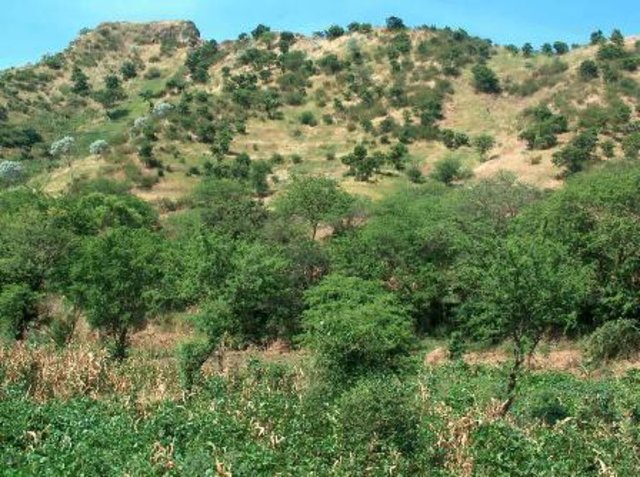
2.3 รูปภาพของเทคโนโลยี
2.5 ประเทศภูมิภาค หรือสถานที่ตั้งที่เทคโนโลยีได้นำไปใช้และได้รับการครอบคลุมโดยการประเมินนี้
ประเทศ:
กาบูเวร์ดี
ภูมิภาค/รัฐ/จังหวัด:
Ribeira Seca
ข้อมูลจำเพาะเพิ่มเติมของสถานที่ตั้ง :
S.Lourenço; Picos; St Cruz; S. Domingos
ระบุการกระจายตัวของเทคโนโลยี:
- กระจายไปอย่างสม่ำเสมอในพื้นที่
If the Technology is evenly spread over an area, specify area covered (in km2):
71.5
แสดงความคิดเห็น:
Total area covered by the SLM Technology is 71.5 km2.
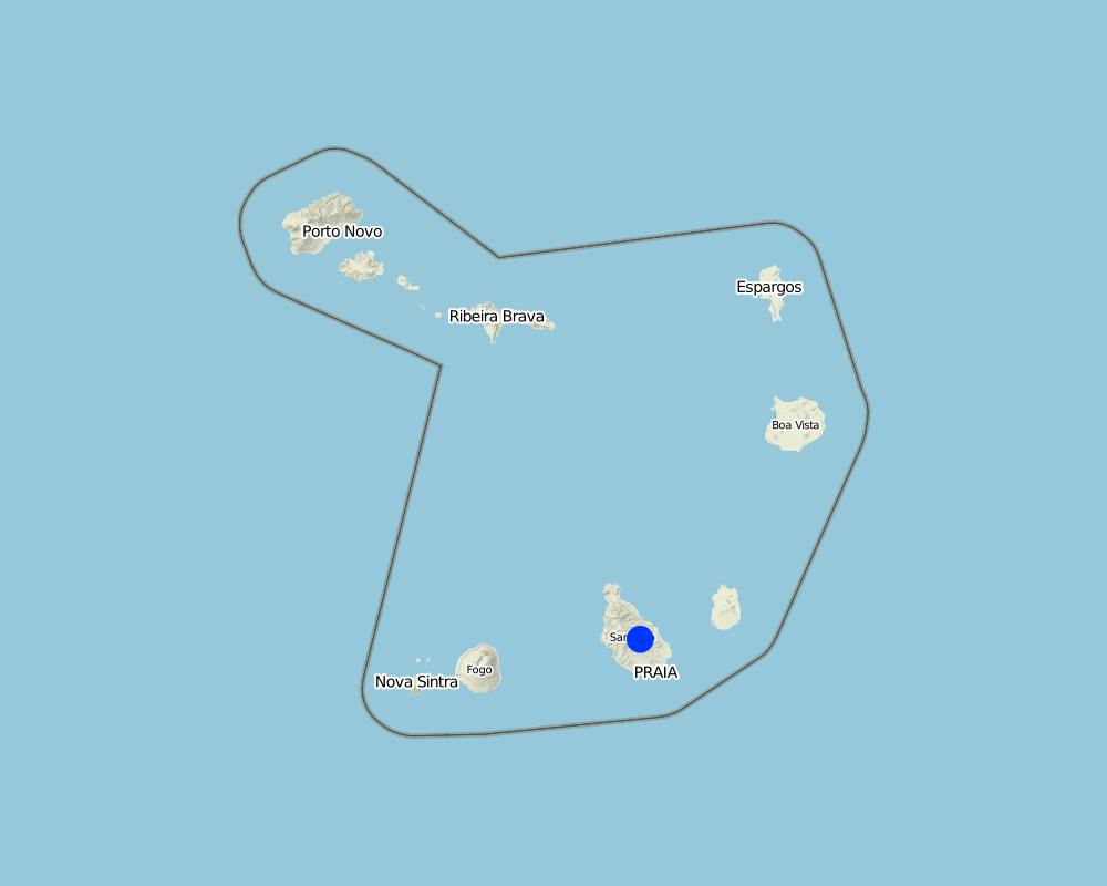
Map
×2.6 วันที่การดำเนินการ
ถ้าไม่รู้ปีที่แน่นอน ให้ระบุวันที่โดยประมาณ:
- 10-50 ปี
2.7 คำแนะนำของเทคโนโลยี
ให้ระบุว่าเทคโนโลยีถูกแนะนำเข้ามาอย่างไร:
- ทางโครงการหรือจากภายนอก
3. การจัดประเภทของเทคโนโลยี SLM
3.1 วัตถุประสงค์หลักของเทคโนโลยี
- ลด ป้องกัน ฟื้นฟู การเสื่อมโทรมของที่ดิน
3.2 ประเภทของการใช้ที่ดินในปัจจุบันที่ได้นำเทคโนโลยีไปใช้

พื้นที่ปลูกพืช
- การปลูกพืชล้มลุกอายุปีเดียว
ระบุ:
Longest growing period in days: 90, Longest growing period from month to month: Aug - Oct

ทางน้ำ แหล่งน้ำ พื้นที่ชุ่มน้ำ
- บ่อน้ำ เขื่อน
แสดงความคิดเห็น:
Major land use problems (compiler’s opinion): Loss of soil by water runoff, reducing its thickness and fertility.
3.3 Has land use changed due to the implementation of the Technology?
Has land use changed due to the implementation of the Technology?
- Yes (Please fill out the questions below with regard to the land use before implementation of the Technology)
ทางน้ำ แหล่งน้ำ พื้นที่ชุ่มน้ำ
3.4 การใช้น้ำ
การใช้น้ำของที่ดินที่มีการใช้เทคโนโลยีอยู่:
- จากน้ำฝน
แสดงความคิดเห็น:
Water supply: Also mixed rainfed - irrigated
3.5 กลุ่ม SLM ที่ตรงกับเทคโนโลยีนี้
- การจัดการน้ำผิวดิน (น้ำพุ แม่น้ำทะเลสาบ ทะเล)
3.6 มาตรการ SLM ที่ประกอบกันเป็นเทคโนโลยี

มาตรการอนุรักษ์ด้วยโครงสร้าง
- S5: เขื่อน ชั้นดินที่แน่นแข็งบ่อน้ำ
3.7 รูปแบบหลักของการเสื่อมโทรมของที่ดินที่ได้รับการแก้ไขโดยเทคโนโลยี

การกัดกร่อนของดินโดยน้ำ
- Wt (Loss of topsoil): การสูญเสียดินชั้นบนหรือการกัดกร่อนที่ผิวดิน
- Wg (Gully erosion): การกัดกร่อนแบบร่องธารหรือการทำให้เกิดร่องน้ำเซาะ

การเสื่อมโทรมของน้ำ
- Hs (Change in quantity of surface water): การเปลี่ยนแปลงปริมาณของน้ำที่ผิวดิน
แสดงความคิดเห็น:
Main causes of degradation: soil management (Intensive use of land.), crop management (annual, perennial, tree/shrub) (Cultivation of maize in areas unsuitable.), over-exploitation of vegetation for domestic use (Cutting of trees for firewood production.), Heavy / extreme rainfall (intensity/amounts) (High-intensity rainfall), education, access to knowledge and support services
Secondary causes of degradation: deforestation / removal of natural vegetation (incl. forest fires), overgrazing, population pressure, poverty / wealth
3.8 การป้องกัน การลดลง หรือการฟื้นฟูความเสื่อมโทรมของที่ดิน
ระบุเป้าหมายของเทคโนโลยีกับความเสื่อมโทรมของที่ดิน:
- ป้องกันความเสื่อมโทรมของที่ดิน
- ลดความเสื่อมโทรมของดิน
4. ข้อมูลจำเพาะด้านเทคนิค กิจกรรมการนำไปปฏิบัติใช้ ปัจจัยนำเข้า และค่าใช้จ่าย
4.1 แบบแปลนทางเทคนิคของเทคโนโลยี
ข้อมูลจำเพาะด้านเทคนิค (แบบแปลนทางเทคนิคของเทคโนโลยี):
The unloading of the dam was scaled to a particular section of the basin Maximum Full Flow (Q) = 30 m3 / s. The height of the dike is 5 meters and the length of the discharge is 20 m and height of 90 cm.
Location: Santiago. Cape Verde
Technical knowledge required for field staff / advisors: high
Main technical functions: control of dispersed runoff: retain / trap, reduction of slope angle, increase of infiltration, increase / maintain water stored in soil, increase of groundwater level / recharge of groundwater, sediment retention / trapping, sediment harvesting
Secondary technical functions: reduction of slope length, water harvesting / increase water supply
Dam/ pan/ pond
Vertical interval between structures (m): 29
Spacing between structures (m): 70.9
Construction material (stone): Of dry stone dykes, the sparrow-hawk or mortar
Construction material (concrete): Usually used in the foundation
Construction material (other): Argamassa: Used in stone masonry of the foundation and elevation. Trace 1:4 or 1:5
Slope (which determines the spacing indicated above): 30%
ผู้เขียน:
Jacques Tavares
4.2 ข้อมูลทั่วไปเกี่ยวกับการคำนวณปัจจัยนำเข้าและค่าใช้จ่าย
อื่นๆ หรือสกุลเงินประจำชาติ (ระบุ):
ECV
If relevant, indicate exchange rate from USD to local currency (e.g. 1 USD = 79.9 Brazilian Real): 1 USD =:
80.0
ระบุค่าเฉลี่ยของค่าจ้างในการจ้างแรงงานต่อวัน:
6.25
4.3 กิจกรรมเพื่อการจัดตั้ง
| กิจกรรม | Timing (season) | |
|---|---|---|
| 1. | Excavation | Dry period |
| 2. | Masonry Foundation | Dry period |
| 3. | Masonry Lifting | Dry period |
4.4 ค่าใช้จ่ายของปัจจัยนำเข้าที่จำเป็นสำหรับการจัดตั้ง
แสดงความคิดเห็น:
Duration of establishment phase: 2.8 month(s)
4.7 ปัจจัยสำคัญที่สุดที่มีผลกระทบต่อค่าใช้จ่าย
ปัจจัยสำคัญที่สุดที่มีผลกระทบต่อค่าใช้จ่ายต่างๆ:
Labor (cost) access due to transport of materials, mainly cement, sand and stone
5. สิ่งแวดล้อมทางธรรมชาติและของมนุษย์
5.1 ภูมิอากาศ
ฝนประจำปี
- < 250 ม.ม.
- 251-500 ม.ม.
- 501-750 ม.ม.
- 751-1,000 ม.ม.
- 1,001-1,500 ม.ม.
- 1,501-2,000 ม.ม.
- 2,001-3,000 ม.ม.
- 3,001-4,000 ม.ม.
- > 4,000 ม.ม.
เขตภูมิอากาศเกษตร
- กึ่งชุ่มชื้น
- กึ่งแห้งแล้ง
5.2 สภาพภูมิประเทศ
ค่าเฉลี่ยความลาดชัน:
- ราบเรียบ (0-2%)
- ลาดที่ไม่ชัน (3-5%)
- ปานกลาง (6-10%)
- เป็นลูกคลื่น (11-15%)
- เป็นเนิน (16-30%)
- ชัน (31-60%)
- ชันมาก (>60%)
ธรณีสัณฐาน:
- ที่ราบสูง/ที่ราบ
- สันเขา
- ไหล่เขา
- ไหล่เนินเขา
- ตีนเนิน
- หุบเขา
ระดับความสูง:
- 0-100 เมตร
- 101-500 เมตร
- 501-1,000 เมตร
- 1,001-1,500 เมตร
- 1,501-2,000 เมตร
- 2,001-2,500 เมตร
- 2,501-3,000 เมตร
- 3,001-4,000 เมตร
- > 4,000 เมตร
5.3 ดิน
ค่าเฉลี่ยความลึกของดิน:
- ตื้นมาก (0-20 ซ.ม.)
- ตื้น (21-50 ซ.ม.)
- ลึกปานกลาง (51-80 ซ.ม.)
- ลึก (81-120 ซ.ม.)
- ลึกมาก (>120 ซ.ม.)
เนื้อดิน (ดินชั้นบน):
- หยาบ/เบา (ดินทราย)
- ปานกลาง (ดินร่วน ทรายแป้ง)
อินทรียวัตถุในดิน:
- ปานกลาง (1-3%)
- ต่ำ (<1%)
(ถ้ามี) ให้แนบคำอธิบายเรื่องดินแบบเต็มหรือระบุข้อมูลที่มีอยู่ เช่น ชนิดของดิน ค่า pH ของดินหรือความเป็นกรดของดิน ความสามารถในการแลกเปลี่ยนประจุบวก ไนโตรเจน ความเค็ม เป็นต้น:
Soil fertility: Medium
Soil drainage/infiltration: Medium (ranked 1) and good (ranked 2)
Soil water storage capacity: Low (ranked 1) and medium (ranked 2, little deep soils with high slopes)
5.4 ความเป็นประโยชน์และคุณภาพของน้ำ
ระดับน้ำใต้ดิน:
5-50 เมตร
น้ำไหลบ่าที่ผิวดิน:
ปานกลาง
คุณภาพน้ำ (ที่ยังไม่ได้บำบัด):
เป็นน้ำเพื่อการดื่มที่ไม่ดี (จำเป็นต้องได้รับการบำบัด)
ความคิดเห็นและข้อมูลจำเพาะเพิ่มเติมเรื่องคุณภาพและปริมาณน้ำ:
Ground water table: Also > 50 m
Availability of surface water: Medium (Sources in the period of rains, but also through galleries)
Water quality (untreated): Also good drinking water (ranked 2)
5.5 ความหลากหลายทางชีวภาพ
ความหลากหลายทางชนิดพันธุ์:
- ต่ำ
5.6 ลักษณะของผู้ใช้ที่ดินที่นำเทคโนโลยีไปปฏิบัติใช้
แนวทางการตลาดของระบบการผลิต:
- เพื่อการยังชีพ (หาเลี้ยงตนเอง)
- mixed (subsistence/ commercial)
ระดับของความมั่งคั่งโดยเปรียบเทียบ:
- จน
- พอมีพอกิน
ระดับของการใช้เครื่องจักรกล:
- งานที่ใช้แรงกาย
- การใช้เครื่องจักรหรือเครื่องยนต์
ระบุลักษณะอื่นๆที่เกี่ยวข้องของผู้ใช้ที่ดิน:
Population density: 100-200 persons/km2
Annual population growth: > 4%; 5% (0.5).
3% of the land users are average wealthy.
80% of the land users are poor.
Market orientation: Subsistence (Many owners have not put their products on the market)
Market orientation: Manual work (ranked 1) and mechanized (ranked 2, some owners rent tractor to plow their land)
5.7 Average area of land used by land users applying the Technology
- < 0.5 เฮกตาร์
- 0.5-1 เฮกตาร์
- 1-2 เฮกตาร์
- 2-5 เฮกตาร์
- 5-15 เฮกตาร์
- 15-50 เฮกตาร์
- 50-100 เฮกตาร์
- 100-500 เฮกตาร์
- 500-1,000 เฮกตาร์
- 1,000-10,000 เฮกตาร์
- >10,000 เฮกตาร์
5.8 กรรมสิทธิ์ในที่ดิน สิทธิในการใช้ที่ดินและสิทธิในการใช้น้ำ
กรรมสิทธิ์ในที่ดิน:
- รายบุคคล ได้รับสิทธิครอบครอง
สิทธิในการใช้ที่ดิน:
- เช่า
- รายบุคคล
สิทธิในการใช้น้ำ:
- เกี่ยวกับชุมชน (ถูกจัดระเบียบ)
- รายบุคคล
5.9 การเข้าถึงบริการและโครงสร้างพื้นฐาน
สุขภาพ:
- จน
- ปานกลาง
- ดี
การศึกษา:
- จน
- ปานกลาง
- ดี
ความช่วยเหลือทางด้านเทคนิค:
- จน
- ปานกลาง
- ดี
การจ้างงาน (เช่น ภายนอกฟาร์ม):
- จน
- ปานกลาง
- ดี
ตลาด:
- จน
- ปานกลาง
- ดี
พลังงาน:
- จน
- ปานกลาง
- ดี
ถนนและการขนส่ง:
- จน
- ปานกลาง
- ดี
น้ำดื่มและการสุขาภิบาล:
- จน
- ปานกลาง
- ดี
บริการด้านการเงิน:
- จน
- ปานกลาง
- ดี
6. ผลกระทบและสรุปคำบอกกล่าว
6.1 ผลกระทบในพื้นที่ดำเนินการ (On-site) จากการใช้เทคโนโลยี
ผลกระทบทางด้านเศรษฐกิจและสังคม
การผลิต
การผลิตพืชผล
การผลิตพืชที่ใช้เลี้ยงปศุสัตว์
การเสี่ยงต่อความล้มเหลวในการผลิต
พื้นที่สำหรับการผลิต
ความเป็นประโยชน์และคุณภาพของน้ำ
การมีน้ำดื่มไว้ให้ใช้
คุณภาพน้ำดื่ม
การมีน้ำไว้ให้ปศุสัตว์
คุณภาพน้ำสำหรับปศุสัตว์
การมีน้ำไว้ให้สำหรับการชลประทาน
คุณภาพน้ำสำหรับการชลประทาน
ผลกระทบด้านสังคมวัฒนธรรมอื่น ๆ
ความมั่นคงด้านอาหาร / พึ่งตนเองได้
SLM หรือความรู้เรื่องความเสื่อมโทรมของที่ดิน
การบรรเทาความขัดแย้ง
สถานการณ์ของกลุ่มด้อยโอกาส ทางด้านสังคมและเศรษฐกิจ
Improved livelihoods and human well-being
แสดงความคิดเห็น/ระบุ:
The construction of a dam can provide increased income for owners benefit, and thus improving their welfare.
ผลกระทบด้านนิเวศวิทยา
วัฐจักรน้ำหรือน้ำบ่า
ปริมาณน้ำ
คุณภาพน้ำ
การเก็บเกี่ยวหรือการกักเก็บน้ำ
น้ำไหลบ่าที่ผิวดิน
น้ำบาดาลหรือระดับน้ำในแอ่งน้ำบาดาล
ดิน
การสูญเสียดิน
6.2 ผลกระทบนอกพื้นที่ดำเนินการ (Off-site) จากการใช้เทคโนโลยี
น้ำที่ใช้ประโยชน์ได้
การไหลของน้ำคงที่และสม่ำเสมอในช่วงฤดูแล้ง
น้ำท่วมพื้นที่ท้ายน้ำ
การทับถมของดินตะกอนพื้นที่ท้ายน้ำ
การเกิดมลพิษในน้ำบาดาลหรือแม่น้ำ
ความเสียหายต่อพื้นที่เพาะปลูกของเพื่อนบ้าน
6.3 การเผชิญและความตอบสนองของเทคโนโลยีต่อการเปลี่ยนแปลงสภาพภูมิอากาศที่ค่อยเป็นค่อยไป และสภาพรุนแรงของภูมิอากาศ / ภัยพิบัติ (ที่รับรู้ได้โดยผู้ใช้ที่ดิน)
การเปลี่ยนแปลงสภาพภูมิอากาศที่ค่อยเป็นค่อยไป
การเปลี่ยนแปลงสภาพภูมิอากาศที่ค่อยเป็นค่อยไป
| ฤดู | increase or decrease | เทคโนโลยีมีวิธีการรับมืออย่างไร | |
|---|---|---|---|
| อุณหภูมิประจำปี | เพิ่มขึ้น | ดี |
สภาพรุนแรงของภูมิอากาศ (ภัยพิบัติ)
ภัยพิบัติทางอุตุนิยมวิทยา
| เทคโนโลยีมีวิธีการรับมืออย่างไร | |
|---|---|
| พายุฝนประจำท้องถิ่น | ดี |
| พายุลมประจำท้องถิ่น | ดี |
6.7 จุดแข็ง / ข้อได้เปรียบ / โอกาสของเทคโนโลยี
| จุดแข็ง / ข้อได้เปรียบ / โอกาสในทัศนคติของผู้ใช้ที่ดิน |
|---|
| Increase in irrigable area for growing crops. |
| Increased availability of water for irrigation, for livestock and for consumption. |
| จุดแข็ง / ข้อได้เปรียบ / โอกาสในทัศนคติของผู้รวบรวมหรือวิทยากรหลัก |
|---|
| Reducing the slope of the bed of the streams and hence the speed of water runoff. |
| Facilitates the infiltration of rain water and hence the recharge of aquifers. |
| Correction of watercourses and protection of the margins of streams. |
| Contributes to increasing and maintaining soil humidity. |
7. การอ้างอิงและการเชื่อมต่อ
7.1 วิธีการและแหล่งข้อมูล
- ไปเยี่ยมชมภาคสนาม การสำรวจพื้นที่ภาคสนาม
- การสัมภาษณ์กับผู้ใช้ที่ดิน
7.2 การอ้างอิงถึงสิ่งตีพิมพ์
หัวข้อ, ผู้เขียน, ปี, หมายเลข ISBN:
Field Trip Guid - DESIRE - INIDA - Cabo Verde, 2008
ชื่อเรื่อง ผู้เขียน ปี ISBN:
Library of INIDA
หัวข้อ, ผู้เขียน, ปี, หมายเลข ISBN:
Técnicas de Conservação de Solos e Água em Cabo Verde, MPAR & CILSS, 1994.
ชื่อเรื่อง ผู้เขียน ปี ISBN:
Library of CFA -INIDA
หัวข้อ, ผู้เขียน, ปี, หมายเลข ISBN:
Conservação de Solo e Água (teoria e prática), Sabino, António Advino, 1991
ชื่อเรื่อง ผู้เขียน ปี ISBN:
Library of CFA -INIDA
หัวข้อ, ผู้เขียน, ปี, หมายเลข ISBN:
Conservação de Solo e Água em Cabo Verde, Sabino, António Advino, 1984
ชื่อเรื่อง ผู้เขียน ปี ISBN:
Library of INIDA
ลิงก์และโมดูล
ขยายทั้งหมด ย่อทั้งหมดลิงก์
Formation, Information et Sensibilisation [กาบูเวร์ดี]
Éclairer les bénéficiares pour les intégrer convenablement dans la mise en ouvre des activités de conservation des ressources naturelles.
- ผู้รวบรวม: Jacques Tavares
โมดูล
ไม่มีโมดูล