Sand dune stabilisation [ไนเจอร์]
- ผู้สร้างสรรค์:
- การอัพเดท:
- ผู้รวบรวม: Dieter Nill
- ผู้เรียบเรียง: –
- ผู้ตรวจสอบ: Fabian Ottiger, Alexandra Gavilano
Fixation des dunes (French)
technologies_1620 - ไนเจอร์
ดูส่วนย่อย
ขยายทั้งหมด ย่อทั้งหมด1. ข้อมูลทั่วไป
1.2 รายละเอียดที่ติดต่อได้ของผู้รวบรวมและองค์กรที่เกี่ยวข้องในการประเมินและการจัดเตรียมทำเอกสารของเทคโนโลยี
ผู้เชี่ยวชาญ SLM:
Dorlöchter-Sulser Sabine
Misereor
เยอรมนี
ผู้เชี่ยวชาญ SLM:
Mamadou Abdou Sani
Programme d’Appui à l’agriculture Productive (PROMAP)/GIZ
ไนเจอร์
ชื่อของโครงการซึ่งอำนวยความสะดวกในการทำเอกสารหรือการประเมินเทคโนโลยี (ถ้าเกี่ยวข้อง)
Manual of Good Practices in Small Scale Irrigation in the Sahel (GIZ )ชื่อขององค์กรซึ่งอำนวยความสะดวกในการทำเอกสารหรือการประเมินเทคโนโลยี (ถ้าเกี่ยวข้อง)
Deutsche Gesellschaft für Internationale Zusammenarbeit (GIZ) - เยอรมนีชื่อขององค์กรซึ่งอำนวยความสะดวกในการทำเอกสารหรือการประเมินเทคโนโลยี (ถ้าเกี่ยวข้อง)
Misereor - เยอรมนี1.3 เงื่อนไขการใช้ข้อมูลที่ได้บันทึกผ่านทาง WOCAT
ผู้รวบรวมและวิทยากรหลักยอมรับเงื่อนไขเกี่ยวกับการใช้ข้อมูลที่ถูกบันทึกผ่านทาง WOCAT:
ใช่
1.4 การเปิดเผยเรื่องความยั่งยืนของเทคโนโลยีที่ได้อธิบายไว้
เทคโนโลยีที่ได้อธิบายไว้นี้เป็นปัญหาของความเสื่อมโทรมโทรมของที่ดินหรือไม่ จึงไม่ได้รับการยอมรับว่าเป็นเทคโนโลยีเพื่อการจัดการที่ดินอย่างยั่งยืน:
ไม่ใช่
1.5 Reference to Questionnaire(s) on SLM Approaches (documented using WOCAT)
Approche participative de réhabilitation des terres individuelles et … [ไนเจอร์]
Planification et gestion des terres individuelles et villageoises sur la base d’une participation des usagers ; promotion simultanée des activités des femmes.
- ผู้รวบรวม: Eric Tielkes
2. การอธิบายลักษณะของเทคโนโลยี SLM
2.1 การอธิบายแบบสั้น ๆ ของเทคโนโลยี
คำจำกัดความของเทคโนโลยี:
Sand dunes are stabilized with vegetation to reduce wind erosion and the amount of sand blown onto cropland, dwellings and other infrastructure.
2.2 การอธิบายแบบละเอียดของเทคโนโลยี
คำอธิบาย:
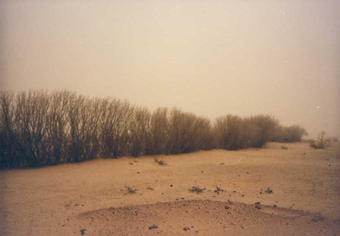
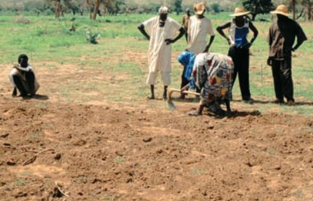
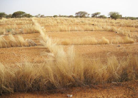
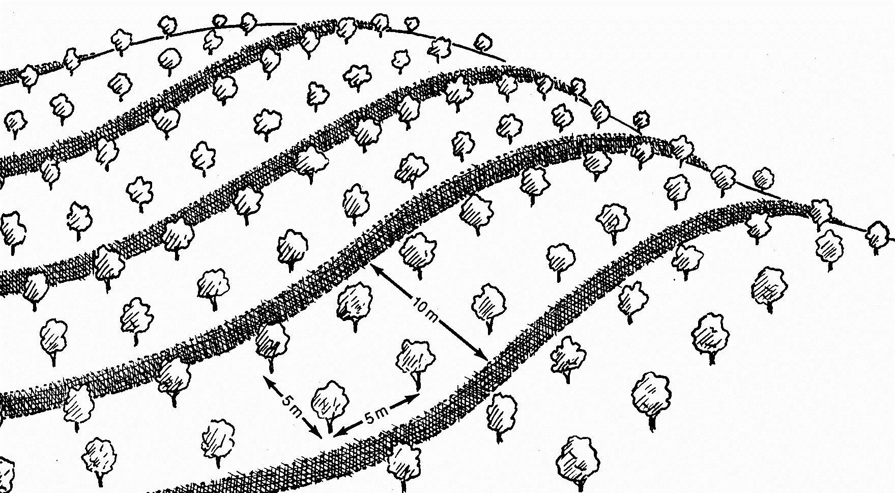
This measure is used to stabilise sand dunes in locations and villages where there is a risk of sand covering cropland or infrastructure (buildings, roads, irrigation systems, etc.). Dune stabilisation is achieved by setting up windbreaks arranged in a checkerboard pattern, with each side measuring between 10 and 15 m. The windbreaks are formed by palisades made from millet stalks or other plant material or by hedges and trees (Leptadenia pyrotechnica, Euphorbia balsamifera, Acacia raddiana, Acacia senegal, Balanites aegyptiaca, Prosopis juliflora, etc.).
Purpose of the Technology: They provide protection from wind erosion and reduce the amount of sand blown onto cropland, dwellings and other infrastructure which can prevent extensive damage. Grass and shrubs are planted in strips in the fenced-off areas to further stabilise the soil. The palisades and vegetation provide shade that lowers soil temperatures and the organic matter and waste improves the soil structure.
Establishment / maintenance activities and inputs: Specific experience is required to assess the degraded area as a whole and choose the most appropriate techniques, the right species to plant and the most suitable locations. Sometimes, the protected area is rehabilitated, particularly when land use pressure is high in neighbouring areas.
The protected dunes must be closely monitored and rigorously maintained for at least three years. It is therefore necessary to ensure good community organisation and take the action required to enforce the rules established and impose fines. Partial use of the area for grazing is sometimes allowed (one day a fortnight). Some projects prefer to fence off the sites with wire fencing to ensure that they are completely protected.
The success of this measure depends to a large extent on climatic conditions. A rainy year after the windbreaks have been erected creates favourable conditions for the species planted to become established.
Natural / human environment: With increasingly stronger winds and the accelerated degradation of the natural vegetation growing on sand dunes, it is very likely that the problems caused by shifting dunes will worsen in the future. Techniques to stabilise shifting sand dunes will therefore become more important.
2.3 รูปภาพของเทคโนโลยี
อัลบั้มสื่อบันทึก
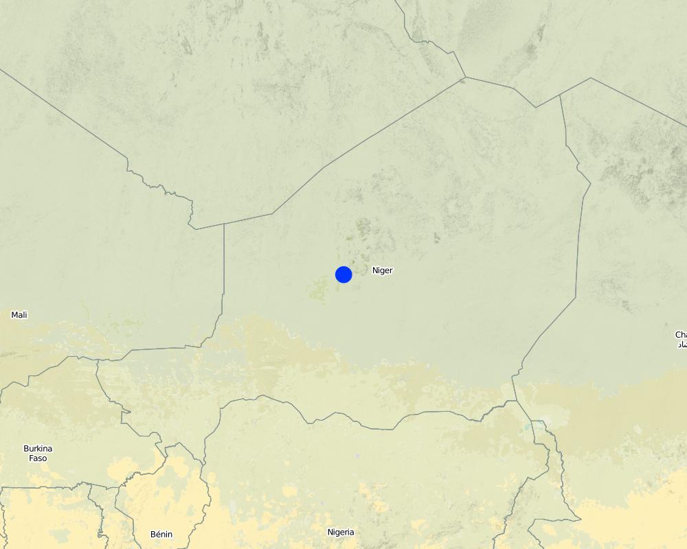
2.5 ประเทศภูมิภาค หรือสถานที่ตั้งที่เทคโนโลยีได้นำไปใช้และได้รับการครอบคลุมโดยการประเมินนี้
ประเทศ:
ไนเจอร์
ภูมิภาค/รัฐ/จังหวัด:
Niger
ระบุการกระจายตัวของเทคโนโลยี:
- กระจายไปอย่างสม่ำเสมอในพื้นที่
If the Technology is evenly spread over an area, specify area covered (in km2):
1.8
If precise area is not known, indicate approximate area covered:
- 1-10 ตร.กม.
แสดงความคิดเห็น:
Total area covered by the SLM Technology is 1.8 km2.
Under the PDRT in Niger, a total area of 180 ha of shifting sand dunes was stabilised, preventing serious damage to dwellings and to the farmland and rangeland that are basic components of the population’s livelihood system.
Map
×2.6 วันที่การดำเนินการ
ถ้าไม่รู้ปีที่แน่นอน ให้ระบุวันที่โดยประมาณ:
- 10-50 ปี
2.7 คำแนะนำของเทคโนโลยี
ให้ระบุว่าเทคโนโลยีถูกแนะนำเข้ามาอย่างไร:
- ทางโครงการหรือจากภายนอก
ความคิดเห็น (ประเภทของโครงการ เป็นต้น) :
developed, implemented and disseminated as part of projects and programmes undertaken from the 1980s onwards to combat desertification and improve natural resource management. Implemented by GIZ (German Federal Enterprise for International Cooperation), PDRT (Projet de développement rural de Tahoua - Tahoua Rural Development Project), PASP (Projet de protection intégrée des ressources agro-sylvo-pastorales Tillabéri-Nord - Project for the Integrated Protection of Agricultural, Forest and Rangeland Resources in Tillabéri-Nord)
3. การจัดประเภทของเทคโนโลยี SLM
3.1 วัตถุประสงค์หลักของเทคโนโลยี
- ลด ป้องกัน ฟื้นฟู การเสื่อมโทรมของที่ดิน
- อนุรักษ์ระบบนิเวศน์
- ปรับตัวเข้ากับการเปลี่ยนแปลงภูมิอากาศของโลก สภาพภูมิอากาศที่รุนแรงและผลกระทบ
3.2 ประเภทของการใช้ที่ดินในปัจจุบันที่ได้นำเทคโนโลยีไปใช้

พื้นที่ปลูกพืช
- การปลูกพืชล้มลุกอายุปีเดียว
จำนวนของฤดูเพาะปลูกต่อปี:
- 1
ระบุ:
Longest growing period in days: 120, Longest growing period from month to month: August to October

ทุ่งหญ้าเลี้ยงสัตว์
แสดงความคิดเห็น:
Major land use problems (compiler’s opinion): wind erosion
Constraints of common grazing land
Constraints of forested government-owned land or commons
3.5 กลุ่ม SLM ที่ตรงกับเทคโนโลยีนี้
- แนวกันลมหรือแนวต้านลม
3.6 มาตรการ SLM ที่ประกอบกันเป็นเทคโนโลยี

มาตรการอนุรักษ์ด้วยวิธีพืช
- V1: ต้นไม้และพุ่มไม้คลุมดิน
- V2: หญ้าและไม้ยืนต้น
แสดงความคิดเห็น:
Type of vegetative measures: aligned: -against wind
3.7 รูปแบบหลักของการเสื่อมโทรมของที่ดินที่ได้รับการแก้ไขโดยเทคโนโลยี

การกัดกร่อนของดินโดยลม
- Et (Loss of topsoil): การสูญเสียดินชั้นบน
- Ed (Deflation and deposition): การกัดกร่อนโดยลมและการทับถม
- Eo (Offsite degradation effect): ผลกระทบนอกพื้นที่

การเสื่อมโทรมของดินทางด้านเคมี
- Cn (Fertility decline): ความอุดมสมบูรณ์และปริมาณอินทรียวัตถุในดินถูกทำให้ลดลงไป (ไม่ได้เกิดจากสาเหตุการกัดกร่อน)
แสดงความคิดเห็น:
Main causes of degradation: soil management (Unadapted landuse methods, reduced or abandoned fallow periods), droughts, population pressure (rapidly growing population increasing pressure on land), land tenure (insecure access to land)
3.8 การป้องกัน การลดลง หรือการฟื้นฟูความเสื่อมโทรมของที่ดิน
ระบุเป้าหมายของเทคโนโลยีกับความเสื่อมโทรมของที่ดิน:
- ป้องกันความเสื่อมโทรมของที่ดิน
- ลดความเสื่อมโทรมของดิน
4. ข้อมูลจำเพาะด้านเทคนิค กิจกรรมการนำไปปฏิบัติใช้ ปัจจัยนำเข้า และค่าใช้จ่าย
4.1 แบบแปลนทางเทคนิคของเทคโนโลยี
ข้อมูลจำเพาะด้านเทคนิค (แบบแปลนทางเทคนิคของเทคโนโลยี):
Dune stabilisation is achieved by setting up windbreaks arranged in a checkerboard pattern, with each side measuring between 10 and 15 m. The windbreaks are formed by palisades made from millet stalks or other plant material or by hedges and trees.
Location: Niger
Technical knowledge required for field staff / advisors: moderate
Technical knowledge required for land users: low
Main technical functions: improvement of ground cover, increase of surface roughness, stabilisation of soil (eg by tree roots against land slides), sediment retention / trapping, sediment harvesting, reduction in wind speed, increase of biomass (quantity), promotion of vegetation species and varieties (quality, eg palatable fodder)
Aligned: -against wind
Vegetative material: T : trees / shrubs, G : grass
Number of plants per (ha): 400
Spacing between rows / strips / blocks (m): 10
Vertical interval within rows / strips / blocks (m): 5
Trees/ shrubs species: Prosopis chilensis, Ziziphus mauritiana, Acacia senegal, Bauhina rufescens, Euphorbia balsamifera.
4.2 ข้อมูลทั่วไปเกี่ยวกับการคำนวณปัจจัยนำเข้าและค่าใช้จ่าย
อื่นๆ หรือสกุลเงินประจำชาติ (ระบุ):
CFA Franc
If relevant, indicate exchange rate from USD to local currency (e.g. 1 USD = 79.9 Brazilian Real): 1 USD =:
521.18
4.3 กิจกรรมเพื่อการจัดตั้ง
| กิจกรรม | Timing (season) | |
|---|---|---|
| 1. | Establish palisade of millet stalk | |
| 2. | Seeding grasses | |
| 3. | Planting | |
| 4. | Spreading manure |
4.4 ค่าใช้จ่ายของปัจจัยนำเข้าที่จำเป็นสำหรับการจัดตั้ง
| ปัจจัยนำเข้า | หน่วย | ปริมาณ | ค่าใช้จ่ายต่อหน่วย | ค่าใช้จ่ายทั้งหมดต่อปัจจัยนำเข้า | %ของค่าใช้จ่ายที่ก่อให้เกิดขึ้นโดยผู้ใช้ที่ดิน | |
|---|---|---|---|---|---|---|
| แรงงาน | Labour | ha | 1.0 | 96.45 | 96.45 | |
| วัสดุด้านพืช | Seedlings | ha | 1.0 | 212.2 | 212.2 | |
| อื่น ๆ | Transport | ha | 1.0 | 115.75 | 115.75 | |
| ค่าใช้จ่ายทั้งหมดของการจัดตั้งเทคโนโลยี | 424.4 | |||||
| Total costs for establishment of the Technology in USD | 0.81 | |||||
4.7 ปัจจัยสำคัญที่สุดที่มีผลกระทบต่อค่าใช้จ่าย
ปัจจัยสำคัญที่สุดที่มีผลกระทบต่อค่าใช้จ่ายต่างๆ:
Labour: 50 man-days per ha
• 60 palisade stakes per ha
• 400 tree and shrub seedlings per ha
• transportation (by lorry) of palisades and seedlings
• protection: costly if the site is protected with wire fencing, which might be stolen.
5. สิ่งแวดล้อมทางธรรมชาติและของมนุษย์
5.1 ภูมิอากาศ
ฝนประจำปี
- < 250 ม.ม.
- 251-500 ม.ม.
- 501-750 ม.ม.
- 751-1,000 ม.ม.
- 1,001-1,500 ม.ม.
- 1,501-2,000 ม.ม.
- 2,001-3,000 ม.ม.
- 3,001-4,000 ม.ม.
- > 4,000 ม.ม.
เขตภูมิอากาศเกษตร
- กึ่งแห้งแล้ง
Thermal climate class: subtropics
5.2 สภาพภูมิประเทศ
ค่าเฉลี่ยความลาดชัน:
- ราบเรียบ (0-2%)
- ลาดที่ไม่ชัน (3-5%)
- ปานกลาง (6-10%)
- เป็นลูกคลื่น (11-15%)
- เป็นเนิน (16-30%)
- ชัน (31-60%)
- ชันมาก (>60%)
ธรณีสัณฐาน:
- ที่ราบสูง/ที่ราบ
- สันเขา
- ไหล่เขา
- ไหล่เนินเขา
- ตีนเนิน
- หุบเขา
ระดับความสูง:
- 0-100 เมตร
- 101-500 เมตร
- 501-1,000 เมตร
- 1,001-1,500 เมตร
- 1,501-2,000 เมตร
- 2,001-2,500 เมตร
- 2,501-3,000 เมตร
- 3,001-4,000 เมตร
- > 4,000 เมตร
5.3 ดิน
ค่าเฉลี่ยความลึกของดิน:
- ตื้นมาก (0-20 ซ.ม.)
- ตื้น (21-50 ซ.ม.)
- ลึกปานกลาง (51-80 ซ.ม.)
- ลึก (81-120 ซ.ม.)
- ลึกมาก (>120 ซ.ม.)
เนื้อดิน (ดินชั้นบน):
- ปานกลาง (ดินร่วน ทรายแป้ง)
- ละเอียด/หนัก (ดินเหนียว)
(ถ้ามี) ให้แนบคำอธิบายเรื่องดินแบบเต็มหรือระบุข้อมูลที่มีอยู่ เช่น ชนิดของดิน ค่า pH ของดินหรือความเป็นกรดของดิน ความสามารถในการแลกเปลี่ยนประจุบวก ไนโตรเจน ความเค็ม เป็นต้น:
Soil fertility: Medium and low
Soil drainage/infiltration: Medium and poor
Soil water storage capacity: Medium and low
5.4 ความเป็นประโยชน์และคุณภาพของน้ำ
ระดับน้ำใต้ดิน:
5-50 เมตร
น้ำไหลบ่าที่ผิวดิน:
ปานกลาง
5.5 ความหลากหลายทางชีวภาพ
ความหลากหลายทางชนิดพันธุ์:
- ต่ำ
5.6 ลักษณะของผู้ใช้ที่ดินที่นำเทคโนโลยีไปปฏิบัติใช้
ระดับของความมั่งคั่งโดยเปรียบเทียบ:
- ยากจนมาก
- จน
เพศ:
- ชาย
ระบุลักษณะอื่นๆที่เกี่ยวข้องของผู้ใช้ที่ดิน:
Population density: 10-50 persons/km2
Annual population growth: 3% - 4% (mostly poor households below poverty line).
Off-farm income specification: men migrate temporarily or permanently to cities for off-farm income
5.7 Average area of land used by land users applying the Technology
- < 0.5 เฮกตาร์
- 0.5-1 เฮกตาร์
- 1-2 เฮกตาร์
- 2-5 เฮกตาร์
- 5-15 เฮกตาร์
- 15-50 เฮกตาร์
- 50-100 เฮกตาร์
- 100-500 เฮกตาร์
- 500-1,000 เฮกตาร์
- 1,000-10,000 เฮกตาร์
- >10,000 เฮกตาร์
พิจารณาว่าเป็นขนาดเล็ก กลาง หรือขนาดใหญ่ (ซึ่งอ้างอิงถึงบริบทระดับท้องถิ่น):
- ขนาดเล็ก
5.8 กรรมสิทธิ์ในที่ดิน สิทธิในการใช้ที่ดินและสิทธิในการใช้น้ำ
กรรมสิทธิ์ในที่ดิน:
- รัฐ
สิทธิในการใช้ที่ดิน:
- เกี่ยวกับชุมชน (ถูกจัดระเบียบ)
สิทธิในการใช้น้ำ:
- เกี่ยวกับชุมชน (ถูกจัดระเบียบ)
แสดงความคิดเห็น:
traditional land use rights on fields, communal land on pasture and forest land
5.9 การเข้าถึงบริการและโครงสร้างพื้นฐาน
สุขภาพ:
- จน
- ปานกลาง
- ดี
การศึกษา:
- จน
- ปานกลาง
- ดี
ความช่วยเหลือทางด้านเทคนิค:
- จน
- ปานกลาง
- ดี
การจ้างงาน (เช่น ภายนอกฟาร์ม):
- จน
- ปานกลาง
- ดี
ตลาด:
- จน
- ปานกลาง
- ดี
พลังงาน:
- จน
- ปานกลาง
- ดี
ถนนและการขนส่ง:
- จน
- ปานกลาง
- ดี
น้ำดื่มและการสุขาภิบาล:
- จน
- ปานกลาง
- ดี
บริการด้านการเงิน:
- จน
- ปานกลาง
- ดี
6. ผลกระทบและสรุปคำบอกกล่าว
6.1 ผลกระทบในพื้นที่ดำเนินการ (On-site) จากการใช้เทคโนโลยี
ผลกระทบทางด้านเศรษฐกิจและสังคม
การผลิต
การผลิตพืชที่ใช้เลี้ยงปศุสัตว์
การผลิตสัตว์
แสดงความคิดเห็น/ระบุ:
Restrictions for grazing in the first three years
พื้นที่สำหรับการผลิต
ผลกระทบด้านสังคมวัฒนธรรมอื่น ๆ
ความมั่นคงด้านอาหาร / พึ่งตนเองได้
SLM หรือความรู้เรื่องความเสื่อมโทรมของที่ดิน
Improved livelihoods and human well-being
แสดงความคิดเห็น/ระบุ:
Sometimes, the protected area is rehabilitated, particularly when land use pressure is high in neighbouring areas. They provide protection from wind erosion and reduce the amount of sand blown onto cropland, dwellings and other infrastructure which can prevent extensive damage.
ผลกระทบด้านนิเวศวิทยา
ดิน
สิ่งปกคลุมดิน
การสูญเสียดิน
ความหลากหลายทางชีวภาพของพืชและสัตว์
ความหลากหลายทางชีวภาพของพืช
ความหลากหลายของสัตว์
ลดความเสี่ยงของภัยพิบัติ
ความเร็วของลม
6.2 ผลกระทบนอกพื้นที่ดำเนินการ (Off-site) จากการใช้เทคโนโลยี
ตะกอนที่ถูกพัดพามาโดยลม
ความเสียหายต่อพื้นที่เพาะปลูกของเพื่อนบ้าน
ความเสียหายต่อโครงสร้างพื้นฐานของรัฐหรือของเอกชน
6.3 การเผชิญและความตอบสนองของเทคโนโลยีต่อการเปลี่ยนแปลงสภาพภูมิอากาศที่ค่อยเป็นค่อยไป และสภาพรุนแรงของภูมิอากาศ / ภัยพิบัติ (ที่รับรู้ได้โดยผู้ใช้ที่ดิน)
การเปลี่ยนแปลงสภาพภูมิอากาศที่ค่อยเป็นค่อยไป
การเปลี่ยนแปลงสภาพภูมิอากาศที่ค่อยเป็นค่อยไป
| ฤดู | increase or decrease | เทคโนโลยีมีวิธีการรับมืออย่างไร | |
|---|---|---|---|
| อุณหภูมิประจำปี | เพิ่มขึ้น | ดี |
สภาพรุนแรงของภูมิอากาศ (ภัยพิบัติ)
ภัยพิบัติทางอุตุนิยมวิทยา
| เทคโนโลยีมีวิธีการรับมืออย่างไร | |
|---|---|
| พายุฝนประจำท้องถิ่น | ดี |
| พายุลมประจำท้องถิ่น | ดี |
ภัยพิบัติจากสภาพภูมิอากาศ
| เทคโนโลยีมีวิธีการรับมืออย่างไร | |
|---|---|
| ภัยจากฝนแล้ง | ดี |
ภัยพิบัติจากน้ำ
| เทคโนโลยีมีวิธีการรับมืออย่างไร | |
|---|---|
| น้ำท่วมตามปกติ (แม่น้ำ) | ดี |
ผลลัพธ์ตามมาที่เกี่ยวข้องกับภูมิอากาศอื่น ๆ
ผลลัพธ์ตามมาที่เกี่ยวข้องกับภูมิอากาศอื่น ๆ
| เทคโนโลยีมีวิธีการรับมืออย่างไร | |
|---|---|
| ช่วงการปลูกพืชที่ลดลงมา | ดี |
6.4 การวิเคราะห์ค่าใช้จ่ายและผลประโยชน์ที่ได้รับ
ผลประโยชน์ที่ได้รับเปรียบเทียบกับค่าใช้จ่ายในการจัดตั้งเป็นอย่างไร (จากมุมมองของผู้ใช้ที่ดิน)
ผลตอบแทนระยะสั้น:
ด้านบวก
ผลตอบแทนระยะยาว:
ด้านบวก
ผลประโยชน์ที่ได้รับเปรียบเทียบกับค่าใช้จ่ายในการบำรุงรักษาหรือต้นทุนที่เกิดขึ้นซ้ำอีก เป็นอย่างไร (จากมุมมองของผู้ใช้ที่ดิน)
ผลตอบแทนระยะสั้น:
ด้านบวก
ผลตอบแทนระยะยาว:
ด้านบวกอย่างมาก
6.5 การปรับตัวของเทคโนโลยี
แสดงความคิดเห็น:
There is a little trend towards spontaneous adoption of the Technology. With increasingly stronger winds and the accelerated degradation of the natural vegetation growing on sand dunes, it is very likely that the problems caused by shifting dunes will worsen in the future. Techniques to stabilise shifting sand dunes will therefore become more important.
6.7 จุดแข็ง / ข้อได้เปรียบ / โอกาสของเทคโนโลยี
| จุดแข็ง / ข้อได้เปรียบ / โอกาสในทัศนคติของผู้รวบรวมหรือวิทยากรหลัก |
|---|
| Protection of infrastructure, cropland and rangeland |
| The palisades and vegetation used to stabilise sand dunes contribute to reducing wind erosion, and the shade that they provide lowers soil temperatures. The protection they provide for farmland and infrastructure can prevent extensive damage. |
| Once the surface of the dune has been stabilised with vegetation, the effect is lasting, provided that the area is not overgrazed. |
6.8 จุดอ่อน / ข้อเสียเปรียบ / ความเสี่ยงของเทคโนโลยีและวิธีการแก้ไข
| จุดอ่อน / ข้อเสียเปรียบ / ความเสี่ยงในทัศนคติของผู้รวบรวมหรือวิทยากรหลัก | มีวิธีการแก้ไขได้อย่างไร |
|---|---|
| Grazing restrictions may reduce animal production. Some projects fence off the sites with wire fencing to ensure that they are completely protected. |
7. การอ้างอิงและการเชื่อมต่อ
7.1 วิธีการและแหล่งข้อมูล
- ไปเยี่ยมชมภาคสนาม การสำรวจพื้นที่ภาคสนาม
- การสัมภาษณ์กับผู้ใช้ที่ดิน
วันที่เก็บรวบรวมข้อมูล(ภาคสนาม) :
01/07/2012
7.2 การอ้างอิงถึงสิ่งตีพิมพ์
หัวข้อ, ผู้เขียน, ปี, หมายเลข ISBN:
Good Practices in Soil and Water Conservation. A contribution to adaptation and farmers´ resilience towards climate change in the Sahel. Published by GIZ in 2012.
ชื่อเรื่อง ผู้เขียน ปี ISBN:
http://agriwaterpedia.info/wiki/Main_Page
ลิงก์และโมดูล
ขยายทั้งหมด ย่อทั้งหมดลิงก์
Approche participative de réhabilitation des terres individuelles et … [ไนเจอร์]
Planification et gestion des terres individuelles et villageoises sur la base d’une participation des usagers ; promotion simultanée des activités des femmes.
- ผู้รวบรวม: Eric Tielkes
โมดูล
ไม่มีโมดูล