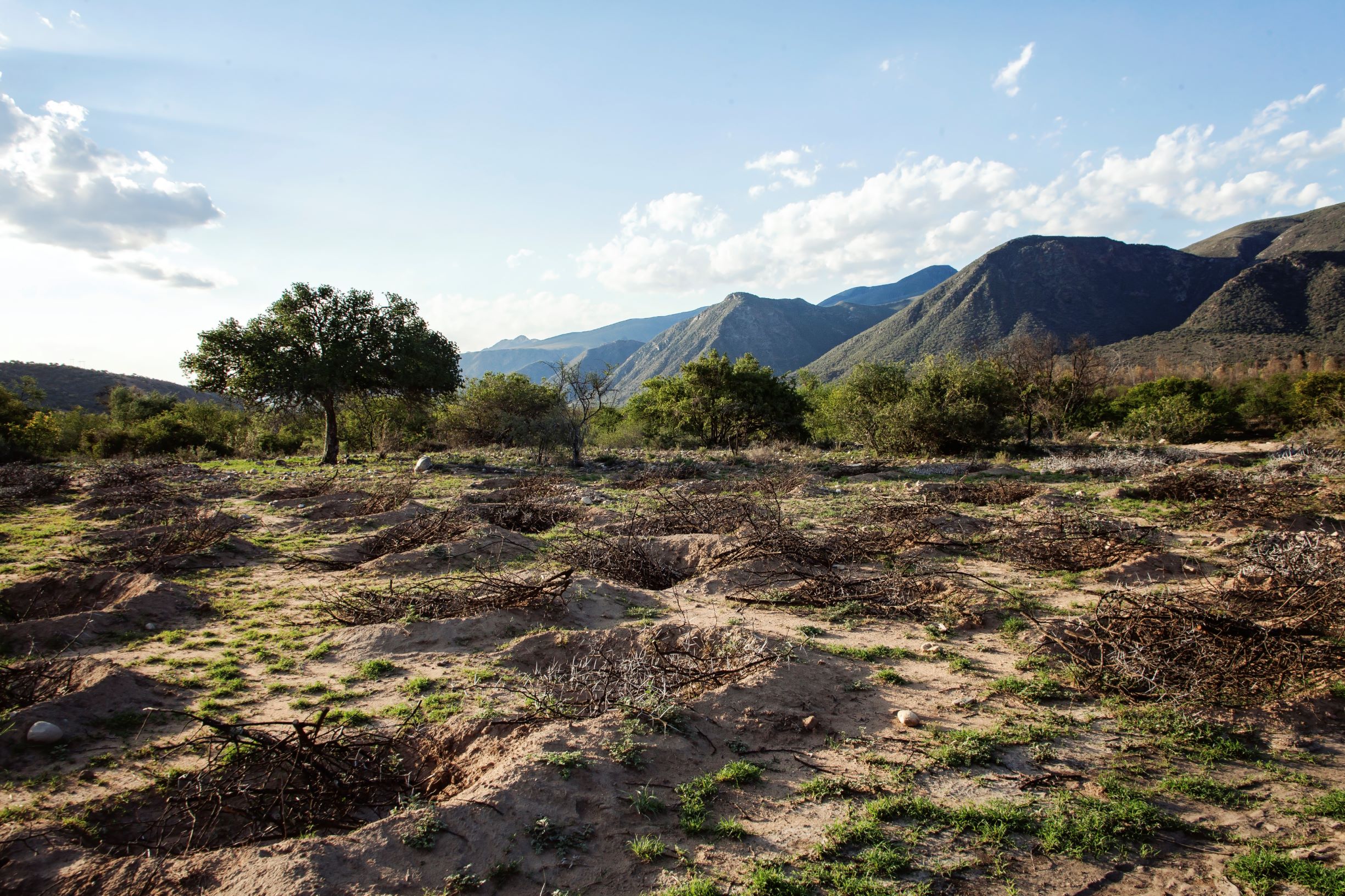
Ponds to establish micro catchments, harvest runoff water and reduce soil erosion. [แอฟริกาใต้]
- ผู้สร้างสรรค์:
- การอัพเดท:
- ผู้รวบรวม: Lehman Lindeque
- ผู้เรียบเรียง: –
- ผู้ตรวจสอบ: Rima Mekdaschi Studer
Ponding
technologies_5801 - แอฟริกาใต้
ดูส่วนย่อย
ขยายทั้งหมด ย่อทั้งหมด1. ข้อมูลทั่วไป
1.2 รายละเอียดที่ติดต่อได้ของผู้รวบรวมและองค์กรที่เกี่ยวข้องในการประเมินและการจัดเตรียมทำเอกสารของเทคโนโลยี
วิทยากรหลัก
ผู้เชี่ยวชาญ SLM:
Beukes Barend Otto
Living Lands
แอฟริกาใต้
ผู้เชี่ยวชาญ SLM:
ผู้เชี่ยวชาญ SLM:
Rudman Justine
Living Lands
แอฟริกาใต้
ผู้เชี่ยวชาญ SLM:
Lunderstedt Kyra
United Nations Development Programme
แอฟริกาใต้
co-compiler:
Gird Justin
Baviaanskloof Hartland Bewaria/Conservancy
แอฟริกาใต้
ชื่อของโครงการซึ่งอำนวยความสะดวกในการทำเอกสารหรือการประเมินเทคโนโลยี (ถ้าเกี่ยวข้อง)
Securing multiple ecosystems benefit through SLM in the productive but degraded landscapes of South Africa (SLM)ชื่อขององค์กรซึ่งอำนวยความสะดวกในการทำเอกสารหรือการประเมินเทคโนโลยี (ถ้าเกี่ยวข้อง)
Living Lands (Collaborations working on living landscapes) - แอฟริกาใต้ชื่อขององค์กรซึ่งอำนวยความสะดวกในการทำเอกสารหรือการประเมินเทคโนโลยี (ถ้าเกี่ยวข้อง)
Rhodes University (Rhodes University) - แอฟริกาใต้1.3 เงื่อนไขการใช้ข้อมูลที่ได้บันทึกผ่านทาง WOCAT
ผู้รวบรวมและวิทยากรหลักยอมรับเงื่อนไขเกี่ยวกับการใช้ข้อมูลที่ถูกบันทึกผ่านทาง WOCAT:
ใช่
1.4 การเปิดเผยเรื่องความยั่งยืนของเทคโนโลยีที่ได้อธิบายไว้
เทคโนโลยีที่ได้อธิบายไว้นี้เป็นปัญหาของความเสื่อมโทรมโทรมของที่ดินหรือไม่ จึงไม่ได้รับการยอมรับว่าเป็นเทคโนโลยีเพื่อการจัดการที่ดินอย่างยั่งยืน:
ไม่ใช่
2. การอธิบายลักษณะของเทคโนโลยี SLM
2.1 การอธิบายแบบสั้น ๆ ของเทคโนโลยี
คำจำกัดความของเทคโนโลยี:
Semi-circular ponds are depressions constructed in the soil to harvest water, reduce runoff, increase infiltration, break soil sealing and crusting, capture organic material and seed where sheet erosion is predominant in degraded, low gradient hillslopes. The opening of the semi-circular pond is up-slope for runoff water to flow into the pond.
2.2 การอธิบายแบบละเอียดของเทคโนโลยี
คำอธิบาย:
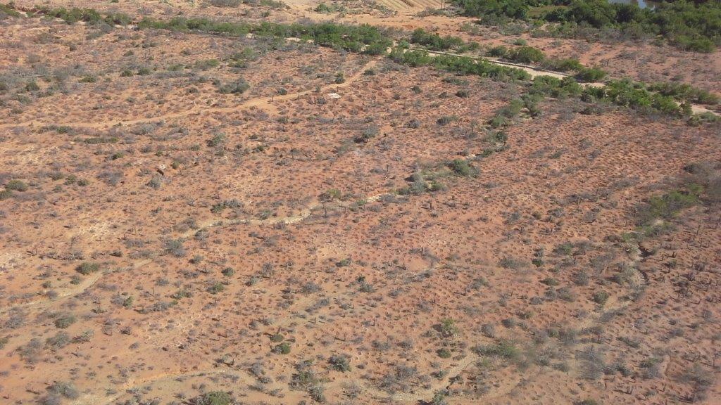
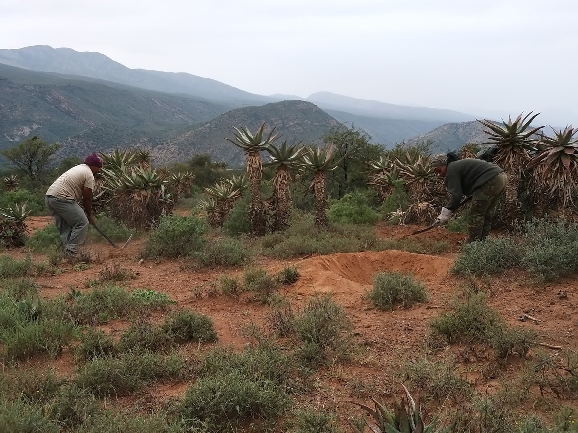
Ponds are applied to disturbed and degraded natural and agricultural areas that have undergone sheet erosion, sealing and crusting on slopes not exceeding 10 degrees. Ponds are constructed of semi-circular hollows dug out of the soil. Ponds are constructed either by hand (micro-ponds) or mechanically using a backhoe-loader or excavator (macro-ponds). Micro ponds are typically 1m wide, 1m long and 30cm deep at its centre, with a water holding capacity of 131 litres. Macro-ponds are typically 3m wide, 3m long and 50cm deep at its centre, with a water holding capacity of approximately 600 litres. The function of ponds is primarily to reduce surface or small rill erosions, reduce water velocity down slope and to harvest water to increase infiltration. Additionally, ponds reduce down-slope siltation of streams, wetlands, dams or reservoirs and even damage to infrastructure like low water bridges, capture seed and organic matter and provide a preferable environment for plant recruitment, particularly in arid areas. Micro-ponds are constructed by pick, to loosen the soil. Loosened soil is then removed by spade and deposited on the downward slope of the pond to form a semi-circular wall similar to that of a dam. The pond wall should be compacted with a spade to reduce breakage during flooding events. Approximately 15% of ponds exhibit broken “dam walls” after two years in extremely arid environments and are greatly dependant on vegetative recruitment. This happened mainly with micro-ponds. Follow-up repairs are advised during the first year, but not thereafter as ponds are also prone to silt up. In arid environments, ponds that do not adequately develop above ground biomass initially are prone to silting closed within three years. Siltation is also dependant on ponding density, spacing and soil type for both micro and macro ponds. The reason for this is they are bigger in size and from our experience, more effective in this arid landscape. Macro-ponds exhibit an increased rate of vegetative recruitment and biomass production, presumably due to less erosion of surface soil and soil nutrients, increased soil moisture content and water retention capacity compared to micro-ponds. Micro-ponds are typically constructed at an average rate of four (4) ponds per hour and 19 ponds per day per person. Production rates are typically 34% lower in hot summer months (2.39 ponds/hour). Macro-ponds are constructed at a rate of approximately 4.43 pond’s per machine hour. Volumetric costs are approximately 31% less expensive when constructed mechanically per litre of water holding capacity. However, large machinery can only be used in severely degraded areas and where access to the project site is available. Ponding density and spacing for micro as well as macro ponds depend on the topography of the landscape to be rehabilitated, the budged and resources available. The more dense, the more effective but also the more expensive the total operation. Some of the threats associated to constructing ponds are soil loss when pond walls break and in the case of steeper slopes may lead to the start of erosion head-cuts if not constructed appropriately. Pond inlets should be constructed at as low gradient decline as possible to reduce the probability of head-cut incision. Ponding at steeper gradients nearing 10-degree slope require particular consideration regarding spacing and density to avoid causing erosion associated to pond breakage. Staggered rows should be considered along the contour. In severely degraded areas, ponds are applied at approximately 400 micro-ponds or 100 mega-ponds per hectare. In severely degraded sites, micro-ponds are applied at approximately 250 ponds per hectare and 160 ponds per hectare in moderately degraded locations. Application rates are greatly determined by soil type and structure, slope, costs and local legislation regarding soil disturbance. Local South African environmental legislation require an Impact Assessment to be done if a certain cubic metres of soil is disturbed, even for rehabilitation purposes. In order to avoid this very costly and tedious approval process, consideration should be given to the amount of soil disturbed or moved. Caution must be taken in severely dispersive soils with regards to soil loss when flooded. Duplex soils are prone to “undercutting” and ponding on these kind of soils should be avoided. Pond depth should be considered with regards to soil water infiltration rates and saturation rate.
The effect of plant growth in and around ponds could also be accelerated or improved by brush packing if material is available in the area. If not, the cost become to high to transport material. Brush packing in the ponds further help to create a micro environment for plant growth by providing a bit of shade, nutrients from the decaying branches and also protection against grazing of newly sprouted plants within the ponds by wildlife occurring naturally in the area. Ponding in semi-arid environments are only used on natural areas, mostly used for grazing of wildlife and livestock. Ponding are usually not used on cultivated fields. Other measures like contours and waterways, vegetative strips are rather used than ponding. There are also very little cultivation happening in semi-arid areas, this project area in Baviaanskloof specifically due to low and unreliable rainfall. Since ponding provide a favourable micro environment for plant growth, grass, shrub and tree species, adaptable and endemic to the area, can be manually planted in the ponds to accelerate vegetative recovery and also to improve the biomass production and species composition in the area. This technology is applied by farmers and land rehabilitation projects. Considering the cost of ponding, it is mainly used in development and restoration projects with donor or government support. In south Africa, this technology is preferred in donor or government funded development project for job creation purposes. Lastly, ponding help reduce soil erosion, increase water infiltration and eventually working towards improve vegetation cover by establishing favourable micro habitats in and around the ponds for vegetation growth. Increased vegetation growth, especially Spekboom, reduced erosion all help to store soil organic carbon and is therefor a carbon mitigation measure as well. Ideally the whole area is withdrawn from grazing for at least 3 years to allow revegation to happen.
2.3 รูปภาพของเทคโนโลยี
อัลบั้มสื่อบันทึก
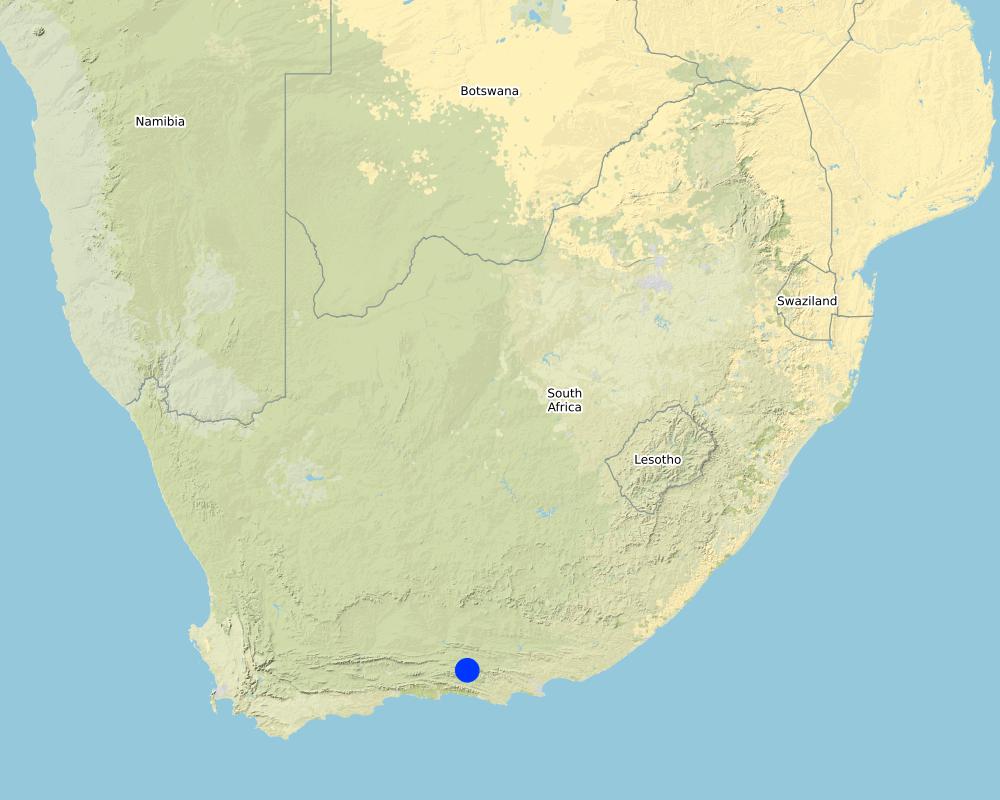
2.5 ประเทศภูมิภาค หรือสถานที่ตั้งที่เทคโนโลยีได้นำไปใช้และได้รับการครอบคลุมโดยการประเมินนี้
ประเทศ:
แอฟริกาใต้
ภูมิภาค/รัฐ/จังหวัด:
Eastern Cape Province
ข้อมูลจำเพาะเพิ่มเติมของสถานที่ตั้ง :
Baviaanskloof
ระบุการกระจายตัวของเทคโนโลยี:
- กระจายไปอย่างสม่ำเสมอในพื้นที่
If the Technology is evenly spread over an area, specify area covered (in km2):
6.0
Is/are the technology site(s) located in a permanently protected area?
ไม่ใช่
Map
×2.6 วันที่การดำเนินการ
ระบุปีที่ใช้:
2019
ถ้าไม่รู้ปีที่แน่นอน ให้ระบุวันที่โดยประมาณ:
- น้อยกว่า 10 ปี (ไม่นานนี้)
2.7 คำแนะนำของเทคโนโลยี
ให้ระบุว่าเทคโนโลยีถูกแนะนำเข้ามาอย่างไร:
- ทางโครงการหรือจากภายนอก
- Existing technology
ความคิดเห็น (ประเภทของโครงการ เป็นต้น) :
GEF 5 Securing multiple ecosystem services through SLM in the degraded but productive landscapes of South Africa. In the described project area, ponding was done mainly through project intervention and also since other projects had great success with the technology in similar landscapes.
3. การจัดประเภทของเทคโนโลยี SLM
3.1 วัตถุประสงค์หลักของเทคโนโลยี
- ลด ป้องกัน ฟื้นฟู การเสื่อมโทรมของที่ดิน
- อนุรักษ์ระบบนิเวศน์
- ป้องกันพื้นที่ลุ่มน้ำ/บริเวณท้ายน้ำ โดยร่วมกับเทคโนโลยีอื่นๆ
- รักษาสภาพหรือปรับปรุงความหลากหลายทางชีวภาพ
- ชะลอการเปลี่ยนแปลงภูมิอากาศของโลกและผลกระทบ
3.2 ประเภทของการใช้ที่ดินในปัจจุบันที่ได้นำเทคโนโลยีไปใช้
Land use mixed within the same land unit:
ไม่ใช่

ทุ่งหญ้าเลี้ยงสัตว์
Extensive grazing:
- การทำฟาร์มปศุสัตว์ (Ranching)
Animal type:
- goats
- mules and asses
- sheep
- wildlife - large herbivours
Is integrated crop-livestock management practiced?
ไม่ใช่

ที่ดินที่ไม่ให้ผลผลิต
ระบุ:
Degraded rangelands
3.3 Has land use changed due to the implementation of the Technology?
Has land use changed due to the implementation of the Technology?
- Yes (Please fill out the questions below with regard to the land use before implementation of the Technology)
Land use mixed within the same land unit:
ไม่ใช่
ทุ่งหญ้าเลี้ยงสัตว์
Extensive grazing:
- การทำฟาร์มปศุสัตว์ (Ranching)
Animal type:
- goats
- mules and asses
- sheep
- wildlife - large herbivours
Is integrated crop-livestock management practiced?
ไม่ใช่
ผลิตภัณฑ์และบริการ:
- meat
- skins/ hides
- whool
ที่ดินที่ไม่ให้ผลผลิต
ระบุ:
Degraded rangelands
แสดงความคิดเห็น:
The change in land use could be potentially from degraded rangeland to more productive rangeland. In this case study, the land is still on its way towards improved productivity, and therefore not utilised at this stage by any livestock.
3.4 การใช้น้ำ
การใช้น้ำของที่ดินที่มีการใช้เทคโนโลยีอยู่:
- จากน้ำฝน
3.5 กลุ่ม SLM ที่ตรงกับเทคโนโลยีนี้
- การปรับปรุงดิน / พืชคลุมดิน
- การเก็บเกี่ยวน้ำ
- การลดความเสี่ยงจากภัยพิบัติบนพื้นฐานของระบบนิเวศ
3.6 มาตรการ SLM ที่ประกอบกันเป็นเทคโนโลยี

มาตรการอนุรักษ์ด้วยวิธีพืช
- V1: ต้นไม้และพุ่มไม้คลุมดิน
- V2: หญ้าและไม้ยืนต้น
- V5: อื่นๆ

มาตรการอนุรักษ์ด้วยโครงสร้าง
- S4: คูน้ำแนวระดับ หลุม
- S7: การกักเก็บน้ำ/การส่งลำเลียง/อุปกรณ์การชลประทาน

มาตรการอนุรักษ์ด้วยการจัดการ
- M1: การเปลี่ยนรูปแบบของการใช้ประโยชน์ที่ดิน
- M2: การเปลี่ยนแปลงของการจัดการหรือระดับความเข้มข้น
แสดงความคิดเห็น:
V5: Packing brush on top of ponds greatly increases vegetative recruitment and survival rates, survival rate of regenerating plants (from seeds or stocks in the soil) and of intentionally newly seeded plants?
3.7 รูปแบบหลักของการเสื่อมโทรมของที่ดินที่ได้รับการแก้ไขโดยเทคโนโลยี

การกัดกร่อนของดินโดยน้ำ
- Wt (Loss of topsoil): การสูญเสียดินชั้นบนหรือการกัดกร่อนที่ผิวดิน
- Wg (Gully erosion): การกัดกร่อนแบบร่องธารหรือการทำให้เกิดร่องน้ำเซาะ
- Wo (Offsite degradation): ผลกระทบนอกพื้นที่

การกัดกร่อนของดินโดยลม
- Et (Loss of topsoil): การสูญเสียดินชั้นบน

การเสื่อมโทรมของดินทางด้านเคมี
- Cn (Fertility decline): ความอุดมสมบูรณ์และปริมาณอินทรียวัตถุในดินถูกทำให้ลดลงไป (ไม่ได้เกิดจากสาเหตุการกัดกร่อน)

การเสื่อมโทรมของดินทางด้านกายภาพ
- Pc (Compaction): การอัดแน่น
- Pk (Slaking and crusting): การอุดตันของช่องว่างในดินหรือรูพรุน
- Pu (Loss of bio-productive function): การสูญเสียหน้าที่การผลิตทางชีวภาพอันเนื่องมาจากกิจกรรม อื่นๆ

การเสื่อมโทรมของดินทางด้านชีวภาพ
- Bc (Reduction of vegetation cover): การลดลงของจำนวนพืชที่ปกคลุมดิน
- Bh (Loss of habitat): การสูญเสียแหล่งที่อยู่
- Bq (Quantity/biomass decline): การลดลงของปริมาณหรือมวลชีวภาพ
- Bs (Quality and species composition): องค์ประกอบหรือความหลากหลายทางคุณภาพและชนิดพันธุ์ลดลง

การเสื่อมโทรมของน้ำ
- Ha (Aridification): การเกิดความแห้งแล้ง
- Hs (Change in quantity of surface water): การเปลี่ยนแปลงปริมาณของน้ำที่ผิวดิน
- Hg (Change in groundwater): การเปลี่ยนแปลงของน้ำบาดาลหรือระดับน้ำในแอ่งน้ำบาดาล
- Hp (Decline of surface water quality): การลดลงของคุณภาพน้ำที่ผิวดิน
- Hw (Reduction of the buffering capacity of wetland): การลดลงของความทนทานต่อการเปลี่ยนแปลง ของพื้นที่ชุ่มน้ำ
3.8 การป้องกัน การลดลง หรือการฟื้นฟูความเสื่อมโทรมของที่ดิน
ระบุเป้าหมายของเทคโนโลยีกับความเสื่อมโทรมของที่ดิน:
- ฟื้นฟูบำบัดที่ดินที่เสื่อมโทรมลงอย่างมาก
- ปรับตัวกับสภาพความเสื่อมโทรมของที่ดิน
4. ข้อมูลจำเพาะด้านเทคนิค กิจกรรมการนำไปปฏิบัติใช้ ปัจจัยนำเข้า และค่าใช้จ่าย
4.1 แบบแปลนทางเทคนิคของเทคโนโลยี
ข้อมูลจำเพาะด้านเทคนิค (แบบแปลนทางเทคนิคของเทคโนโลยี):
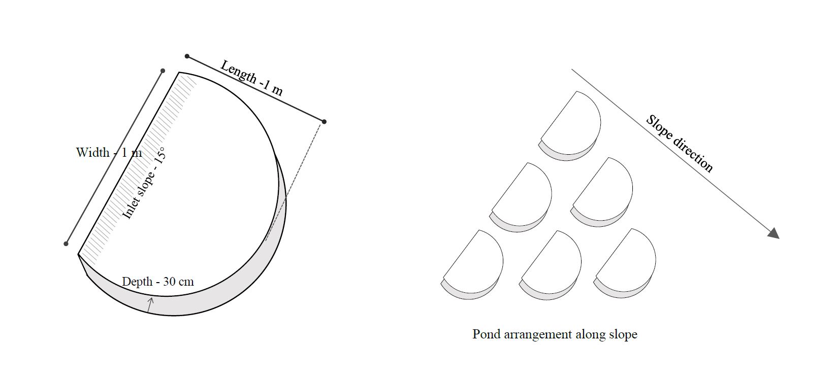
The technical drawing on the left shows the measurements of a typical average micro-pond. Its about 1m wide on the upstream (open) end and about 1m to the semi-circular edge wall on the downstream side. The pond should be dug out with a spade at an angle of 15 degrees towards the wall of the pond at the downstream end. Use the removed soil to form the semi-circular edge wall as illustrated on the left hand drawing. Use the spade or your feet to compact the soil of the semi-circular wall.
The drawing on the right illustrates the pond arrangement along a slope. The ponds should be staggered in lines across the contour to make sure the water flowing between ponds in the first line, flows into the ponds in the second line or row. The ponds don't need to be exactly in lines across the contour, but it is very important that the pond openings are perpendicular to the slope direction and form an appearance of fish scales.
ผู้เขียน:
Kyra Lunderstedt
วันที่:
08/07/2020
4.2 ข้อมูลทั่วไปเกี่ยวกับการคำนวณปัจจัยนำเข้าและค่าใช้จ่าย
ให้ระบุว่าค่าใช้จ่ายและปัจจัยนำเข้าได้รับการคำนวณอย่างไร:
- ต่อพื้นที่ที่ใช้เทคโนโลยี
ระบุขนาดและหน่วยพื้นที่:
600 ha
อื่นๆ หรือสกุลเงินประจำชาติ (ระบุ):
South African Rand
If relevant, indicate exchange rate from USD to local currency (e.g. 1 USD = 79.9 Brazilian Real): 1 USD =:
15.0
ระบุค่าเฉลี่ยของค่าจ้างในการจ้างแรงงานต่อวัน:
ZAR 150 - ZAR 262
4.3 กิจกรรมเพื่อการจัดตั้ง
| กิจกรรม | Timing (season) | |
|---|---|---|
| 1. | Terrain inspection and pecking out pond positions and lines | Any time of the year |
| 2. | Manual digging of micro-ponds | Any time of the year |
| 3. | Seeding of ponds (Optional) | Before or at start of rain season |
| 4. | Brush packing if material is available | Any time of the year |
| 5. | Inspection and maintenance of ponds | During the rainy season, especially after heavy thunderstorms |
แสดงความคิดเห็น:
Mainly micro-ponds were used in the area. Macro-ponds where tested for comparison purposes. Equipment needed for macro-ponds Volvo BL61 Backhoe-loader (Vehicle and operator = ZAR 300/hour, Fuel = ZAR 75/hour).
4.4 ค่าใช้จ่ายของปัจจัยนำเข้าที่จำเป็นสำหรับการจัดตั้ง
| ปัจจัยนำเข้า | หน่วย | ปริมาณ | ค่าใช้จ่ายต่อหน่วย | ค่าใช้จ่ายทั้งหมดต่อปัจจัยนำเข้า | %ของค่าใช้จ่ายที่ก่อให้เกิดขึ้นโดยผู้ใช้ที่ดิน | |
|---|---|---|---|---|---|---|
| แรงงาน | Manual digging of micro-ponds | Person-days | 1677.0 | 215.0 | 360555.0 | 0.0 |
| อุปกรณ์ | Spade | Number | 24.0 | 250.0 | 6000.0 | 0.0 |
| อุปกรณ์ | Pick | Number | 24.0 | 350.0 | 8400.0 | 0.0 |
| วัสดุด้านพืช | Grass seeds | 25 kg bags | 10.0 | 250.0 | 2500.0 | |
| อื่น ๆ | Transport | km | 15960.0 | 6.2 | 98952.0 | 0.0 |
| อื่น ๆ | Staff overheads | Per person day | 1677.0 | 76.0 | 127452.0 | 0.0 |
| อื่น ๆ | Management | Per field day | 399.0 | 438.0 | 174762.0 | 0.0 |
| ค่าใช้จ่ายทั้งหมดของการจัดตั้งเทคโนโลยี | 778621.0 | |||||
| Total costs for establishment of the Technology in USD | 51908.07 | |||||
ถ้าผู้ใช้ที่ดินรับภาระน้อยกว่า 100% ของค่าใช้จ่าย ให้ระบุว่าใครเป็นผู้รับผิดชอบส่วนที่เหลือ:
Living Lands NGO working in the Baviaanskloof. In certain cases, depending on availability of external inputs, farmers could contribute by providing labour for example or use there own tools or transport for workers.
แสดงความคิดเห็น:
Donor funding through the United Nations Development Programme, Global Environmental Facility (GEF 5)
4.5 การบำรุงรักษาสภาพหรือกิจกรรมที่เกิดขึ้นเป็นประจำ
| กิจกรรม | ช่วงระยะเวลา/ความถี่ | |
|---|---|---|
| 1. | Restructuring of broken ponds (S) | After heavy rain event |
| 2. | Densification (S) (More ponds are dug when needed | After rain event and assessment of effective functioning and impact |
| 3. | Supplementary seeding (V) | Dependant on species seasonality |
| 4. | Brush-packing | After ponding to increase plant recruitment & survival |
4.6 ค่าใช้จ่ายของปัจจัยนำเข้าและกิจกรรมที่เกิดขึ้นเป็นประจำที่ต้องการการบำรุงรักษา (ต่อปี)
If you are unable to break down the costs in the table above, give an estimation of the total costs of maintaining the Technology:
25000.0
ถ้าผู้ใช้ที่ดินรับภาระน้อยกว่า 100% ของค่าใช้จ่าย ให้ระบุว่าใครเป็นผู้รับผิดชอบส่วนที่เหลือ:
Living Lands NGO working in the Baviaanskloof
แสดงความคิดเห็น:
Donor funding through the United Nations Development Programme, Global Environmental Facility (GEF 5)
4.7 ปัจจัยสำคัญที่สุดที่มีผลกระทบต่อค่าใช้จ่าย
ปัจจัยสำคัญที่สุดที่มีผลกระทบต่อค่าใช้จ่ายต่างๆ:
For manually constructed ponds: Climatic conditions, particularly heat. Productivity (labour) is approximately 34% greater in the cooler winter months (April-October) and reduce during summer months with regular temperatures above 30°C. The activity is generally stopped when temperatures exceed 32°C. Soil structure (Clay, Sand and rock proportions particularly) effect production rate and longevity. High rock content and dense silt and clay soils reduce productivity (rate at which ponds are dug manually).
When constructing ponds mechanically, soil structure appears to have the greatest effect on production rates.
5. สิ่งแวดล้อมทางธรรมชาติและของมนุษย์
5.1 ภูมิอากาศ
ฝนประจำปี
- < 250 ม.ม.
- 251-500 ม.ม.
- 501-750 ม.ม.
- 751-1,000 ม.ม.
- 1,001-1,500 ม.ม.
- 1,501-2,000 ม.ม.
- 2,001-3,000 ม.ม.
- 3,001-4,000 ม.ม.
- > 4,000 ม.ม.
ระบุปริมาณน้ำฝนเฉลี่ยรายปี (ถ้ารู้) :หน่วย ม.ม.
280.00
ข้อมูลจำเพาะ/ความคิดเห็นเรื่องปริมาณน้ำฝน:
: 60% summer rainfall, 40% winter rainfall. Thunder storms in summer deposit large quantities at once (>50mm/occasion). 67% standard deviation around mean across 100 years recorded. Peak rainfall September and March, but no predictable long term or annual patterns. Less than half mean annual rainfall per year from 2015-2019 during analysed implementation period. March and April are the only months that have not experienced zero rainfall over a 100-year period. Approximately 30 days per annum are frost prone in the implementation area
เขตภูมิอากาศเกษตร
- แห้งแล้ง
PET effects do not exceed 10mm of effective rainfall per month. Approximately 43mm of rainfall per annum is effective
5.2 สภาพภูมิประเทศ
ค่าเฉลี่ยความลาดชัน:
- ราบเรียบ (0-2%)
- ลาดที่ไม่ชัน (3-5%)
- ปานกลาง (6-10%)
- เป็นลูกคลื่น (11-15%)
- เป็นเนิน (16-30%)
- ชัน (31-60%)
- ชันมาก (>60%)
ธรณีสัณฐาน:
- ที่ราบสูง/ที่ราบ
- สันเขา
- ไหล่เขา
- ไหล่เนินเขา
- ตีนเนิน
- หุบเขา
ระดับความสูง:
- 0-100 เมตร
- 101-500 เมตร
- 501-1,000 เมตร
- 1,001-1,500 เมตร
- 1,501-2,000 เมตร
- 2,001-2,500 เมตร
- 2,501-3,000 เมตร
- 3,001-4,000 เมตร
- > 4,000 เมตร
ให้ระบุถ้าเทคโนโลยีได้ถูกนำไปใช้:
- ไม่เกี่ยวข้อง
ความคิดเห็นและข้อมูลจำเพาะเพิ่มเติมเรื่องสภาพภูมิประเทศ:
Less than 10 degree (17%) slope
5.3 ดิน
ค่าเฉลี่ยความลึกของดิน:
- ตื้นมาก (0-20 ซ.ม.)
- ตื้น (21-50 ซ.ม.)
- ลึกปานกลาง (51-80 ซ.ม.)
- ลึก (81-120 ซ.ม.)
- ลึกมาก (>120 ซ.ม.)
เนื้อดิน (ดินชั้นบน):
- ปานกลาง (ดินร่วน ทรายแป้ง)
- ละเอียด/หนัก (ดินเหนียว)
เนื้อดินล่าง (> 20 ซ.ม.ต่ำจากผิวดิน):
- ปานกลาง (ดินร่วน ทรายแป้ง)
- ละเอียด/หนัก (ดินเหนียว)
อินทรียวัตถุในดิน:
- ปานกลาง (1-3%)
- ต่ำ (<1%)
5.4 ความเป็นประโยชน์และคุณภาพของน้ำ
ระดับน้ำใต้ดิน:
5-50 เมตร
น้ำไหลบ่าที่ผิวดิน:
ปานกลาง
คุณภาพน้ำ (ที่ยังไม่ได้บำบัด):
เป็นน้ำเพื่อการดื่มที่ดี
Water quality refers to:
surface water
ความเค็มของน้ำเป็นปัญหาหรือไม่:
ไม่ใช่
กำลังเกิดน้ำท่วมในพื้นที่หรือไม่:
ใช่
บ่อยครั้ง:
บ่อยครั้ง
ความคิดเห็นและข้อมูลจำเพาะเพิ่มเติมเรื่องคุณภาพและปริมาณน้ำ:
Soil water saturation occurs after 10 to 20 mm of rainfall. Runoff occurs rapidly. River and tributaries are predominantly dry, excepting upwellings and springs, and only flow after prolonged or severe rain events
5.5 ความหลากหลายทางชีวภาพ
ความหลากหลายทางชนิดพันธุ์:
- ต่ำ
ความหลากหลายของแหล่งที่อยู่:
- ต่ำ
ความคิดเห็นและข้อมูลจำเพาะเพิ่มเติมของความหลากหลายทางชีวภาพ:
The Baviaanskloof region is specifically rich in biodiversity with a wide range of habitat units. Degradation has lead to low levels of diversity
5.6 ลักษณะของผู้ใช้ที่ดินที่นำเทคโนโลยีไปปฏิบัติใช้
อยู่กับที่หรือเร่ร่อน:
- อยู่กับที่
แนวทางการตลาดของระบบการผลิต:
- ทำการค้า/การตลาด
รายได้ที่มาจากนอกฟาร์ม:
- < 10% ของรายได้ทั้งหมด
ระดับของความมั่งคั่งโดยเปรียบเทียบ:
- จน
เป็นรายบุคคล/ครัวเรือน:
- เป็นรายบุคคล/ครัวเรือน
- สหกรณ์
ระดับของการใช้เครื่องจักรกล:
- งานที่ใช้แรงกาย
- การใช้เครื่องจักรหรือเครื่องยนต์
เพศ:
- หญิง
- ชาย
อายุของผู้ใช้ที่ดิน:
- ผู้เยาว์
- วัยกลางคน
5.7 Average area of land used by land users applying the Technology
- < 0.5 เฮกตาร์
- 0.5-1 เฮกตาร์
- 1-2 เฮกตาร์
- 2-5 เฮกตาร์
- 5-15 เฮกตาร์
- 15-50 เฮกตาร์
- 50-100 เฮกตาร์
- 100-500 เฮกตาร์
- 500-1,000 เฮกตาร์
- 1,000-10,000 เฮกตาร์
- >10,000 เฮกตาร์
พิจารณาว่าเป็นขนาดเล็ก กลาง หรือขนาดใหญ่ (ซึ่งอ้างอิงถึงบริบทระดับท้องถิ่น):
- ขนาดเล็ก
- ขนาดกลาง
5.8 กรรมสิทธิ์ในที่ดิน สิทธิในการใช้ที่ดินและสิทธิในการใช้น้ำ
กรรมสิทธิ์ในที่ดิน:
- เป็นแบบชุมชนหรือหมู่บ้าน
- รายบุคคล ได้รับสิทธิครอบครอง
สิทธิในการใช้ที่ดิน:
- เกี่ยวกับชุมชน (ถูกจัดระเบียบ)
- รายบุคคล
สิทธิในการใช้น้ำ:
- เกี่ยวกับชุมชน (ถูกจัดระเบียบ)
- รายบุคคล
Are land use rights based on a traditional legal system?
ใช่
ระบุ:
Land tenure is communal, many beneficiaries but one title deed. Shared water from common sources. Water use rights associated to title deeds
5.9 การเข้าถึงบริการและโครงสร้างพื้นฐาน
สุขภาพ:
- จน
- ปานกลาง
- ดี
การศึกษา:
- จน
- ปานกลาง
- ดี
ความช่วยเหลือทางด้านเทคนิค:
- จน
- ปานกลาง
- ดี
การจ้างงาน (เช่น ภายนอกฟาร์ม):
- จน
- ปานกลาง
- ดี
ตลาด:
- จน
- ปานกลาง
- ดี
พลังงาน:
- จน
- ปานกลาง
- ดี
ถนนและการขนส่ง:
- จน
- ปานกลาง
- ดี
น้ำดื่มและการสุขาภิบาล:
- จน
- ปานกลาง
- ดี
บริการด้านการเงิน:
- จน
- ปานกลาง
- ดี
6. ผลกระทบและสรุปคำบอกกล่าว
6.1 ผลกระทบในพื้นที่ดำเนินการ (On-site) จากการใช้เทคโนโลยี
ผลกระทบทางด้านเศรษฐกิจและสังคม
การผลิต
การผลิตพืชที่ใช้เลี้ยงปศุสัตว์
แสดงความคิดเห็น/ระบุ:
Increased soil moisture content and prolonged retention
คุณภาพพืชที่ใช้เลี้ยงปศุสัตว์
แสดงความคิดเห็น/ระบุ:
General biomass increase, pioneer species variable
พื้นที่สำหรับการผลิต
แสดงความคิดเห็น/ระบุ:
Increased biomass on previously sealed and crusted soils
การจัดการที่ดิน
แสดงความคิดเห็น/ระบุ:
Slight increased production and maintenance.
ความเป็นประโยชน์และคุณภาพของน้ำ
การมีน้ำไว้ให้ปศุสัตว์
แสดงความคิดเห็น/ระบุ:
Increased infiltration, groundwater and surface water
รายได้และค่าใช้จ่าย
ภาระงาน
ผลกระทบด้านสังคมวัฒนธรรมอื่น ๆ
สถาบันของชุมชน
แสดงความคิดเห็น/ระบุ:
Increased rangeland quality
SLM หรือความรู้เรื่องความเสื่อมโทรมของที่ดิน
แสดงความคิดเห็น/ระบุ:
Consequences of overgrazing and subsequent erosion
ผลกระทบด้านนิเวศวิทยา
วัฐจักรน้ำหรือน้ำบ่า
ปริมาณน้ำ
แสดงความคิดเห็น/ระบุ:
Reduction in runoff and siltation
การเก็บเกี่ยวหรือการกักเก็บน้ำ
แสดงความคิดเห็น/ระบุ:
Improved capture of surface runoff
น้ำไหลบ่าที่ผิวดิน
ดิน
ความชื้นในดิน
จำนวนก่อน SLM:
5%
หลังจาก SLM:
11.5%
แสดงความคิดเห็น/ระบุ:
Gravametric soil moisture content increase (n=320; randomized pond vs control). The initial decrease is by cultivating soils to build the ponds
สิ่งปกคลุมดิน
แสดงความคิดเห็น/ระบุ:
Significant increase of fractional green canopy cover
การสูญเสียดิน
แสดงความคิดเห็น/ระบุ:
Decreased sheet erosion
การสะสมของดิน
แสดงความคิดเห็น/ระบุ:
Soil accumulation in the ponds
การเกิดแผ่นแข็งที่ผิวดิน /การเกิดชั้นดาน
แสดงความคิดเห็น/ระบุ:
Localized
การอัดแน่นของดิน
แสดงความคิดเห็น/ระบุ:
Localized
ความหลากหลายทางชีวภาพของพืชและสัตว์
การปกคลุมด้วยพืช
แสดงความคิดเห็น/ระบุ:
Localized
มวลชีวภาพ/เหนือดินชั้น C
แสดงความคิดเห็น/ระบุ:
Localized
ความหลากหลายทางชีวภาพของสัตว์
หลังจาก SLM:
400%
แสดงความคิดเห็น/ระบุ:
Insect diversity
ผลกระทบด้านนิเวศวิทยาอื่น ๆ
Plant recruitment
แสดงความคิดเห็น/ระบุ:
Increase woody and herbaceous seedling recruitment
6.2 ผลกระทบนอกพื้นที่ดำเนินการ (Off-site) จากการใช้เทคโนโลยี
น้ำท่วมพื้นที่ท้ายน้ำ
แสดงความคิดเห็น/ระบุ:
Positive effect, reduced runoff
การทับถมของดินตะกอนพื้นที่ท้ายน้ำ
แสดงความคิดเห็น/ระบุ:
Positive effect, reduced siltation
6.3 การเผชิญและความตอบสนองของเทคโนโลยีต่อการเปลี่ยนแปลงสภาพภูมิอากาศที่ค่อยเป็นค่อยไป และสภาพรุนแรงของภูมิอากาศ / ภัยพิบัติ (ที่รับรู้ได้โดยผู้ใช้ที่ดิน)
การเปลี่ยนแปลงสภาพภูมิอากาศที่ค่อยเป็นค่อยไป
การเปลี่ยนแปลงสภาพภูมิอากาศที่ค่อยเป็นค่อยไป
| ฤดู | increase or decrease | เทคโนโลยีมีวิธีการรับมืออย่างไร | |
|---|---|---|---|
| อุณหภูมิประจำปี | เพิ่มขึ้น | ปานกลาง | |
| ฝนประจำปี | ลดลง | ปานกลาง |
สภาพรุนแรงของภูมิอากาศ (ภัยพิบัติ)
ภัยพิบัติทางอุตุนิยมวิทยา
| เทคโนโลยีมีวิธีการรับมืออย่างไร | |
|---|---|
| พายุฝนประจำท้องถิ่น | ดีมาก |
| พายุฝนฟ้าคะนองประจำท้องถิ่น | ดี |
ภัยพิบัติจากสภาพภูมิอากาศ
| เทคโนโลยีมีวิธีการรับมืออย่างไร | |
|---|---|
| คลื่นความร้อน | ดี |
| ภัยจากฝนแล้ง | ปานกลาง |
| ไฟบนบก | ไม่ทราบ |
ภัยพิบัติจากน้ำ
| เทคโนโลยีมีวิธีการรับมืออย่างไร | |
|---|---|
| น้ำท่วมตามปกติ (แม่น้ำ) | ไม่ดี |
| น้ำท่วมฉับพลัน | ไม่ค่อยดี |
6.4 การวิเคราะห์ค่าใช้จ่ายและผลประโยชน์ที่ได้รับ
ผลประโยชน์ที่ได้รับเปรียบเทียบกับค่าใช้จ่ายในการจัดตั้งเป็นอย่างไร (จากมุมมองของผู้ใช้ที่ดิน)
ผลตอบแทนระยะสั้น:
ด้านลบ
ผลตอบแทนระยะยาว:
ด้านบวกเล็กน้อย
ผลประโยชน์ที่ได้รับเปรียบเทียบกับค่าใช้จ่ายในการบำรุงรักษาหรือต้นทุนที่เกิดขึ้นซ้ำอีก เป็นอย่างไร (จากมุมมองของผู้ใช้ที่ดิน)
ผลตอบแทนระยะสั้น:
ด้านบวก
ผลตอบแทนระยะยาว:
ด้านบวกอย่างมาก
6.5 การปรับตัวของเทคโนโลยี
- > 50%
ถ้ามีข้อมูลให้บอกปริมาณด้วย (จำนวนของครัวเรือนหรือครอบคลุมพื้นที่):
600 ha
Of all those who have adopted the Technology, how many did so spontaneously, i.e. without receiving any material incentives/ payments?
- 0-10%
6.6 การปรับตัว
เทคโนโลยีได้รับการปรับเปลี่ยนเมื่อเร็วๆนี้ เพื่อให้ปรับตัวเข้ากับสภาพที่กำลังเปลี่ยนแปลงหรือไม่:
ใช่
ถ้าตอบว่าใช่ ให้ระบุว่าเงื่อนไขการเปลี่ยนแปลงใดที่ถูกปรับตัว:
- การเปลี่ยนแปลงแบบค่อยเป็นค่อยไปและสภาพรุนแรงของภูมิอากาศ
ให้ระบุการปรับตัวของเทคโนโลยี (การออกแบบ วัสดุหรือชนิดพันธุ์ เป็นต้น):
Packing with thorn brush from pruned pioneer trees (Vachelia karoo), planting of trees (Portulacaria afra) and seeding (Predominantly grass spp.)
6.7 จุดแข็ง / ข้อได้เปรียบ / โอกาสของเทคโนโลยี
| จุดแข็ง / ข้อได้เปรียบ / โอกาสในทัศนคติของผู้ใช้ที่ดิน |
|---|
| It creates employment opportunities for unskilled labourers |
| Plants return to barren areas |
| Increased grazing capacity for small stock |
| จุดแข็ง / ข้อได้เปรียบ / โอกาสในทัศนคติของผู้รวบรวมหรือวิทยากรหลัก |
|---|
| The technology is simple and extremely adaptable to ecological and economic variables through changes in density and dimension |
| The technology is relatively inexpensive and effective |
| The technology is relatively risk free when applied within application criteria |
6.8 จุดอ่อน / ข้อเสียเปรียบ / ความเสี่ยงของเทคโนโลยีและวิธีการแก้ไข
| จุดอ่อน / ข้อเสียเปรียบ / ความเสี่ยงในทัศนคติของผู้ใช้ที่ดิน | มีวิธีการแก้ไขได้อย่างไร |
|---|---|
| Production rates are slow, labourers require access to land to construct ponds for extended periods of time | Use larger labour forces to complete areas faster |
| Ponds are slow to revegetate in drought conditions | Seeding and brush-packing increase recruitment and survival rates |
| Unwanted pioneer weedy species may recruit and outcompete slower growing desired species | Seeding with or planting preferable pioneer species |
| จุดอ่อน / ข้อเสียเปรียบ / ความเสี่ยงในทัศนคติของผู้รวบรวมหรือวิทยากรหลัก | มีวิธีการแก้ไขได้อย่างไร |
|---|---|
| Ponds may silt up before recruiting new vegetation, particularly during heavy rain events and is highly dispersive soils | Apply more stringent site selection criteria based on climatic and soil conditions. Adjust pond size and density to reduce rate of siltation |
7. การอ้างอิงและการเชื่อมต่อ
7.1 วิธีการและแหล่งข้อมูล
- ไปเยี่ยมชมภาคสนาม การสำรวจพื้นที่ภาคสนาม
3 postgraduate research students
- การสัมภาษณ์กับผู้ใช้ที่ดิน
6 land owners
- การสัมภาษณ์ผู้เชี่ยวชาญด้าน SLM หรือผู้ชำนาญ
4 workshops
วันที่เก็บรวบรวมข้อมูล(ภาคสนาม) :
2019
แสดงความคิดเห็น:
Data compiled between 2016 and 2019
7.2 การอ้างอิงถึงสิ่งตีพิมพ์
หัวข้อ, ผู้เขียน, ปี, หมายเลข ISBN:
•Caring for Natural Rangelands, Ken Coetzee, University of KwaZulu-Natal Press, 2005, ISBN:1869140710, 9781869140717, 129 pages.
ชื่อเรื่อง ผู้เขียน ปี ISBN:
ZAR 129
หัวข้อ, ผู้เขียน, ปี, หมายเลข ISBN:
•De Abraeu,, P. 2011. Unpublished thesis. The effect of rehabilitation on ecosystem services in the semi-arid Succulent Karoo lowlands of the Little Karoo, South Africa. University of Cape Town, South Africa
ชื่อเรื่อง ผู้เขียน ปี ISBN:
http://www.pcu.uct.ac.za/sites/default/files/image_tool/images/192/de%20abreu%202010.pdf
7.3 Links to relevant online information
ชื่อเรื่องหรือคำอธิบาย:
Just dig it
URL:
www.justdigit.org https://www.youtube.com/watch?v=eXWVC3RKmb8
ชื่อเรื่องหรือคำอธิบาย:
Greener Land
URL:
http://www.greener.land/index.php/product/demi-lunes-semi-circular-bunds/
ชื่อเรื่องหรือคำอธิบาย:
Living Lands
URL:
www.livinglands.co.za https://youtu.be/BmhWMqEu-oU?list=PL4dQ3giQTjAxtMON61PFvLSIqrM7Xq_Jy
ชื่อเรื่องหรือคำอธิบาย:
Common Land
URL:
www.commonland.co.za
ชื่อเรื่องหรือคำอธิบาย:
•Environmental Monitoring Group
URL:
https://www.youtube.com/channel/UCjGScyyexvSqQVkJXtuat6w
ชื่อเรื่องหรือคำอธิบาย:
•UNDP GEF5 South Africa
URL:
https://www.za.undp.org/content/south_africa/en/home/operations/projects/environment_https://www.za.undp.org/content/south_africa/en/home/operations/projects/environment_and_energy/securing-multiple-ecosystems-benefit-through-sustainable-land-ma.htmland
ลิงก์และโมดูล
ขยายทั้งหมด ย่อทั้งหมดลิงก์
ไม่มีลิงก์
โมดูล
ไม่มีโมดูล