Strip-till [เยอรมนี]
- ผู้สร้างสรรค์:
- การอัพเดท:
- ผู้รวบรวม: Felix Witing
- ผู้เรียบเรียง: Michael Strauch, Mona Pauer
- ผู้ตรวจสอบ: William Critchley, Rima Mekdaschi Studer
Streifenbearbeitung
technologies_6257 - เยอรมนี
ดูส่วนย่อย
ขยายทั้งหมด ย่อทั้งหมด1. ข้อมูลทั่วไป
1.2 รายละเอียดที่ติดต่อได้ของผู้รวบรวมและองค์กรที่เกี่ยวข้องในการประเมินและการจัดเตรียมทำเอกสารของเทคโนโลยี
ผู้เชี่ยวชาญ SLM:
ผู้เชี่ยวชาญ SLM:
ชื่อของโครงการซึ่งอำนวยความสะดวกในการทำเอกสารหรือการประเมินเทคโนโลยี (ถ้าเกี่ยวข้อง)
OPtimal strategies to retAIN and re-use water and nutrients in small agricultural catchments across different soil-climatic regions in Europe (OPTAIN)ชื่อขององค์กรซึ่งอำนวยความสะดวกในการทำเอกสารหรือการประเมินเทคโนโลยี (ถ้าเกี่ยวข้อง)
Helmholtz Centre for Environmental Research (UFZ) - เยอรมนี1.3 เงื่อนไขการใช้ข้อมูลที่ได้บันทึกผ่านทาง WOCAT
ผู้รวบรวมและวิทยากรหลักยอมรับเงื่อนไขเกี่ยวกับการใช้ข้อมูลที่ถูกบันทึกผ่านทาง WOCAT:
ใช่
1.4 การเปิดเผยเรื่องความยั่งยืนของเทคโนโลยีที่ได้อธิบายไว้
เทคโนโลยีที่ได้อธิบายไว้นี้เป็นปัญหาของความเสื่อมโทรมโทรมของที่ดินหรือไม่ จึงไม่ได้รับการยอมรับว่าเป็นเทคโนโลยีเพื่อการจัดการที่ดินอย่างยั่งยืน:
ไม่ใช่
2. การอธิบายลักษณะของเทคโนโลยี SLM
2.1 การอธิบายแบบสั้น ๆ ของเทคโนโลยี
คำจำกัดความของเทคโนโลยี:
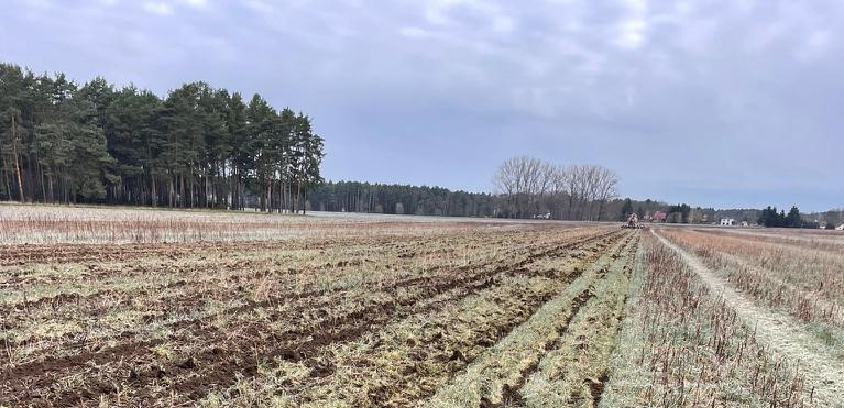
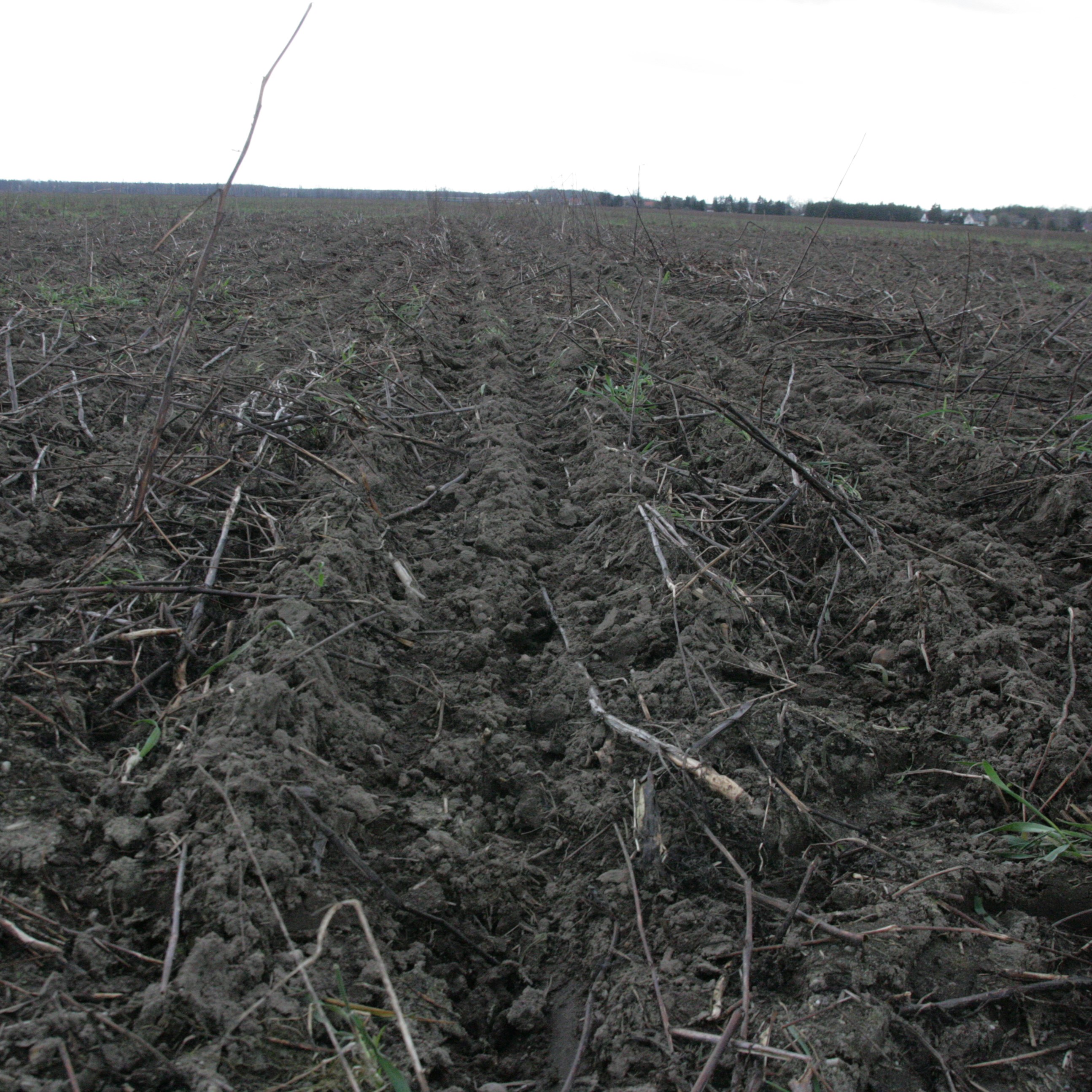
Strip-till is a form of precision farming and conservation agriculture that combines minimum tillage in strips with no-till on the remainder of the field. The soil over the whole field is protected by a growing crop or mulch from sunlight, and especially from the direct impact of raindrops by providing permanent soil cover.
2.2 การอธิบายแบบละเอียดของเทคโนโลยี
คำอธิบาย:
Conservation agriculture includes cultivation systems with minimum tillage or without tillage (no-till). Minimum tillage uses machinery (cultivators, rotary tillers) that only loosen the topsoil layer without turning it, leaving a mixture of bare soil and crop residues from the previous crop/ cover crop on the surface. No-till refers to sowing and fertilizing directly into the plant residues. Strip-till is a hybrid, where only the strip around the seed furrow is minimum-tilled, leaving up to two-thirds of the area under no-till.
Strip-till increases surface roughness, which slows the flow of surface water after heavy rains, improving infiltration rates and particle deposition, thus preventing soil erosion, nutrient losses and degradation of water quality in downstream channels and rivers. The plant residues reduce soil crust formation and decrease evaporation rates (Gangan et al. 2022). The residues also improve biological activity and the build-up of soil organic matter (SOM) and clay-humus complexes. The increased SOM content improves water storage capacity and thus water use efficiency throughout the growing season (Stadler, 2014; Busari et al. 2015).
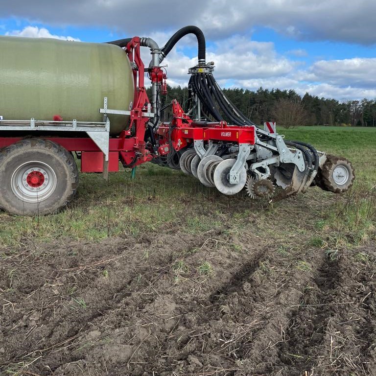
Strip-till seeding is a precision farming technology that requires a high precision GPS guidance system and specific machinery, such as seed drills to cut through crop residues. The distance beween the strips depends on the cultivated crop. For maize cultivation it is typically 75cm. Strip-till machinery is often heavier than conventional seeding drills because the undisturbed soil is denser and harder. Often a new tractor with more horsepower is needed to compensate for the heavy weights. If mulch seeding is used, grain harvesters equipped with well-designed straw/chaff spreading devices across the full cutting width are required (Corsi & Muminjanov, 2019).
Strip-till also has negative side effects, which are related to the disadvantages of no-till: delayed soil warming, soil compaction, increased disease pressure, and increased weed pressure. Without ploughing, other measures such as selecting fast-growing and effective ground cover species, early high-density seeding, and/or using herbicides are needed to control weeds, especially in the transition period (first 2-3 years) when the seed bank in the soil is well-filled.
In our documented example, the farmer used strip-till on sandy soils (lacking nutrients, with poor water-holding capacity) and combined it with the application of organic fertilizer. Specifically the strip-till seeding of maize was chosen to make efficient use of digestate from a biogas plant. The digestate is applied in the tilled strips (seed bed) providing organic fertilizer for the whole growing season. A winter-killed catch crop was sown before drilling maize. The technology required expensive machinery and equipment, such as a Volmer Strip-Till Culex ML, RTK station and GPS guidance system. However, the costs were recouped through savings in fuel and fertilizer.
2.3 รูปภาพของเทคโนโลยี
อัลบั้มสื่อบันทึก
2.5 ประเทศภูมิภาค หรือสถานที่ตั้งที่เทคโนโลยีได้นำไปใช้และได้รับการครอบคลุมโดยการประเมินนี้
ประเทศ:
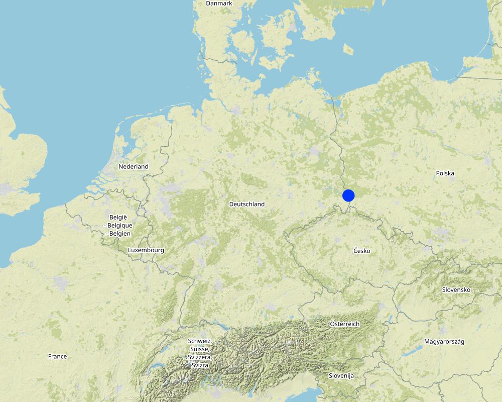
เยอรมนี
ภูมิภาค/รัฐ/จังหวัด:
Saxony
ข้อมูลจำเพาะเพิ่มเติมของสถานที่ตั้ง :
Uhsmannsdorf (Nieder Horka)
ระบุการกระจายตัวของเทคโนโลยี:
- กระจายไปอย่างสม่ำเสมอในพื้นที่
If precise area is not known, indicate approximate area covered:
- 1-10 ตร.กม.
Is/are the technology site(s) located in a permanently protected area?
ไม่ใช่
Map
×2.6 วันที่การดำเนินการ
ถ้าไม่รู้ปีที่แน่นอน ให้ระบุวันที่โดยประมาณ:
- 10-50 ปี
2.7 คำแนะนำของเทคโนโลยี
ให้ระบุว่าเทคโนโลยีถูกแนะนำเข้ามาอย่างไร:
- ด้วยการริเริ่มของผู้ใช้ที่ดินเอง
ความคิดเห็น (ประเภทของโครงการ เป็นต้น) :
The farmer wanted to have a system to effectively incorporate biogas residues.
3. การจัดประเภทของเทคโนโลยี SLM
3.1 วัตถุประสงค์หลักของเทคโนโลยี
- ปรับปรุงการผลิตให้ดีขึ้น
- ลด ป้องกัน ฟื้นฟู การเสื่อมโทรมของที่ดิน
- ปรับตัวเข้ากับการเปลี่ยนแปลงภูมิอากาศของโลก สภาพภูมิอากาศที่รุนแรงและผลกระทบ
- สร้างผลกระทบทางด้านเศรษฐกิจที่เป็นประโยชน์
- To effectively incorporate biogas residues.
3.2 ประเภทของการใช้ที่ดินในปัจจุบันที่ได้นำเทคโนโลยีไปใช้
Land use mixed within the same land unit:
ไม่ใช่

พื้นที่ปลูกพืช
- การปลูกพืชล้มลุกอายุปีเดียว
Annual cropping - Specify crops:
- cereals - maize
- cereals - rye
- Winter-killed cover crop (e.g. mustard) before maize
จำนวนของฤดูเพาะปลูกต่อปี:
- 1
Is intercropping practiced?
ไม่ใช่
Is crop rotation practiced?
ใช่
ถ้าใช่ ระบุ:
silage maize, rye, rye
3.3 Has land use changed due to the implementation of the Technology?
Has land use changed due to the implementation of the Technology?
- No (Continue with question 3.4)
3.4 การใช้น้ำ
การใช้น้ำของที่ดินที่มีการใช้เทคโนโลยีอยู่:
- จากน้ำฝน
3.5 กลุ่ม SLM ที่ตรงกับเทคโนโลยีนี้
- การปรับปรุงดิน / พืชคลุมดิน
- การรบกวนดินให้น้อยที่สุด
- การจัดการความอุดมสมบรูณ์ของดินแบบผสมผสาน
3.6 มาตรการ SLM ที่ประกอบกันเป็นเทคโนโลยี

มาตรการจัดการพืช
- A1: พืช/สิ่งปกคลุมดิน
- A2: อินทรียวัตถุในดิน/ความอุดมสมบูรณ์ในดิน
- A3: การรักษาหน้าดิน
- A6: Residue management
A3: Differentiate tillage systems:
A 3.2: Reduced tillage (> 30% soil cover)
A6: Specify residue management:
A 6.4: retained
3.7 รูปแบบหลักของการเสื่อมโทรมของที่ดินที่ได้รับการแก้ไขโดยเทคโนโลยี

การกัดกร่อนของดินโดยน้ำ
- Wt (Loss of topsoil): การสูญเสียดินชั้นบนหรือการกัดกร่อนที่ผิวดิน
- Wg (Gully erosion): การกัดกร่อนแบบร่องธารหรือการทำให้เกิดร่องน้ำเซาะ

การกัดกร่อนของดินโดยลม
- Et (Loss of topsoil): การสูญเสียดินชั้นบน
- Ed (Deflation and deposition): การกัดกร่อนโดยลมและการทับถม

การเสื่อมโทรมของดินทางด้านเคมี
- Cn (Fertility decline): ความอุดมสมบูรณ์และปริมาณอินทรียวัตถุในดินถูกทำให้ลดลงไป (ไม่ได้เกิดจากสาเหตุการกัดกร่อน)

การเสื่อมโทรมของดินทางด้านกายภาพ
- Pc (Compaction): การอัดแน่น
- Pk (Slaking and crusting): การอุดตันของช่องว่างในดินหรือรูพรุน
- Pu (Loss of bio-productive function): การสูญเสียหน้าที่การผลิตทางชีวภาพอันเนื่องมาจากกิจกรรม อื่นๆ

การเสื่อมโทรมของดินทางด้านชีวภาพ
- Bc (Reduction of vegetation cover): การลดลงของจำนวนพืชที่ปกคลุมดิน
- Bh (Loss of habitat): การสูญเสียแหล่งที่อยู่
- Bl (Loss of soil life): การสูญเสียสิ่งมีชีวิตในดิน

การเสื่อมโทรมของน้ำ
- Ha (Aridification): การเกิดความแห้งแล้ง
- Hs (Change in quantity of surface water): การเปลี่ยนแปลงปริมาณของน้ำที่ผิวดิน
- Hp (Decline of surface water quality): การลดลงของคุณภาพน้ำที่ผิวดิน
3.8 การป้องกัน การลดลง หรือการฟื้นฟูความเสื่อมโทรมของที่ดิน
ระบุเป้าหมายของเทคโนโลยีกับความเสื่อมโทรมของที่ดิน:
- ป้องกันความเสื่อมโทรมของที่ดิน
- ลดความเสื่อมโทรมของดิน
4. ข้อมูลจำเพาะด้านเทคนิค กิจกรรมการนำไปปฏิบัติใช้ ปัจจัยนำเข้า และค่าใช้จ่าย
4.1 แบบแปลนทางเทคนิคของเทคโนโลยี
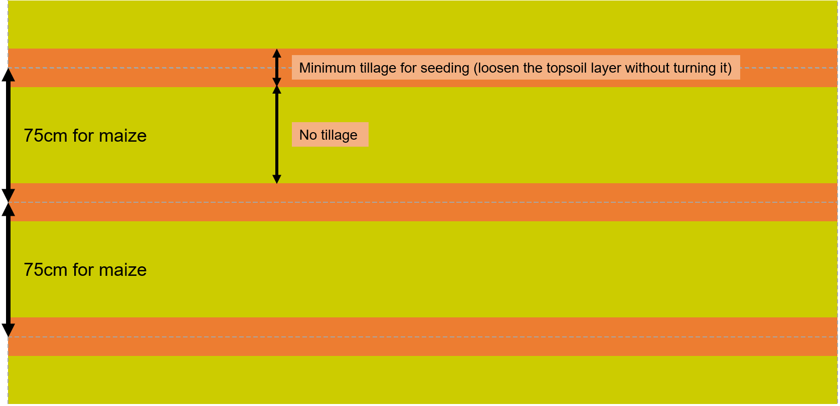
ข้อมูลจำเพาะด้านเทคนิค (แบบแปลนทางเทคนิคของเทคโนโลยี):
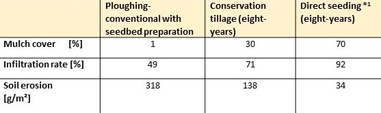
*1: Direct seeding is quite similar to strip-till
ผู้เขียน:
Schmidt et al. (2001)
ข้อมูลจำเพาะด้านเทคนิค (แบบแปลนทางเทคนิคของเทคโนโลยี):
The distance between the strips depends on the cultivated crop. For maize cultivation it is typically 75cm. For other row-crops (e.g. sugar beet) or rapeseed the distance between the tilled strips can be lower.
ผู้เขียน:
Felix Witing
วันที่:
07/08/2023
4.2 ข้อมูลทั่วไปเกี่ยวกับการคำนวณปัจจัยนำเข้าและค่าใช้จ่าย
ให้ระบุว่าค่าใช้จ่ายและปัจจัยนำเข้าได้รับการคำนวณอย่างไร:
- ต่อพื้นที่ที่ใช้เทคโนโลยี
ระบุขนาดและหน่วยพื้นที่:
1 ha
อื่นๆ หรือสกุลเงินประจำชาติ (ระบุ):
€
If relevant, indicate exchange rate from USD to local currency (e.g. 1 USD = 79.9 Brazilian Real): 1 USD =:
0.91
ระบุค่าเฉลี่ยของค่าจ้างในการจ้างแรงงานต่อวัน:
18.70€ per hour
4.3 กิจกรรมเพื่อการจัดตั้ง
| กิจกรรม | Timing (season) | |
|---|---|---|
| 1. | Equipment purchase | |
| 2. | Installation of precision farming technology (RTK station, GPS guidance system) |
4.4 ค่าใช้จ่ายของปัจจัยนำเข้าที่จำเป็นสำหรับการจัดตั้ง
| ปัจจัยนำเข้า | หน่วย | ปริมาณ | ค่าใช้จ่ายต่อหน่วย | ค่าใช้จ่ายทั้งหมดต่อปัจจัยนำเข้า | %ของค่าใช้จ่ายที่ก่อให้เกิดขึ้นโดยผู้ใช้ที่ดิน | |
|---|---|---|---|---|---|---|
| อุปกรณ์ | GPS-guidance system | GPS-guidance system | 1.0 | 25000.0 | 25000.0 | 100.0 |
| อุปกรณ์ | Volmer Strip-till Culex ML | Vomer Strip-till Culex ML | 1.0 | 25000.0 | 25000.0 | 100.0 |
| อุปกรณ์ | RTK-station | RTK-station | 1.0 | 17500.0 | 17500.0 | 100.0 |
| ค่าใช้จ่ายทั้งหมดของการจัดตั้งเทคโนโลยี | 67500.0 | |||||
| Total costs for establishment of the Technology in USD | 74175.82 | |||||
ถ้าผู้ใช้ที่ดินรับภาระน้อยกว่า 100% ของค่าใช้จ่าย ให้ระบุว่าใครเป็นผู้รับผิดชอบส่วนที่เหลือ:
Farmer stated that it is complicated to get subsidies. He said: "equipment subsidies are like a lottery".
แสดงความคิดเห็น:
There are no details available about the operating life of the machinery - thus no "per hectare per year" calculation can be estimated.
4.5 การบำรุงรักษาสภาพหรือกิจกรรมที่เกิดขึ้นเป็นประจำ
| กิจกรรม | ช่วงระยะเวลา/ความถี่ | |
|---|---|---|
| 1. | Spreading biogas digestate | March/April |
| 2. | Combined strip-till | April/May |
| 3. | Weed bonitour | June |
| 4. | Crop protection measure | June |
| 5. | Silage | September/October |
| 6. | Transport to biogas plant | September/October |
4.6 ค่าใช้จ่ายของปัจจัยนำเข้าและกิจกรรมที่เกิดขึ้นเป็นประจำที่ต้องการการบำรุงรักษา (ต่อปี)
If you are unable to break down the costs in the table above, give an estimation of the total costs of maintaining the Technology:
-73.0
ถ้าผู้ใช้ที่ดินรับภาระน้อยกว่า 100% ของค่าใช้จ่าย ให้ระบุว่าใครเป็นผู้รับผิดชอบส่วนที่เหลือ:
80€/ha are covered by the state of saxony, AL_2 Strip seeding/ direct seeding (SMUL Sachsen, 2015)
แสดงความคิดเห็น:
According to the farmer, there are few additional costs to maintain the technology, but there are savings in diesel, labor, etc., resulting in total savings of approx. -73€/ha.
It is not possible for external experts (given the information available) to calculate, independently, the annual costs with any reliability.
4.7 ปัจจัยสำคัญที่สุดที่มีผลกระทบต่อค่าใช้จ่าย
ปัจจัยสำคัญที่สุดที่มีผลกระทบต่อค่าใช้จ่ายต่างๆ:
If the work is done by a contracting company, the costs are 10-20% higher.
5. สิ่งแวดล้อมทางธรรมชาติและของมนุษย์
5.1 ภูมิอากาศ
ฝนประจำปี
- < 250 ม.ม.
- 251-500 ม.ม.
- 501-750 ม.ม.
- 751-1,000 ม.ม.
- 1,001-1,500 ม.ม.
- 1,501-2,000 ม.ม.
- 2,001-3,000 ม.ม.
- 3,001-4,000 ม.ม.
- > 4,000 ม.ม.
ระบุปริมาณน้ำฝนเฉลี่ยรายปี (ถ้ารู้) :หน่วย ม.ม.
739.00
ระบุชื่อของสถานีตรวดวัดอากาศที่ใช้อ้างอิงคือ:
https://whh-kliwes.de/mapview
เขตภูมิอากาศเกษตร
- ชื้น
- กึ่งชุ่มชื้น
Length of growing period (LGP): 209
(https://www.umwelt.sachsen.de/dauer-der-vegetationsperiode-30631.html)
5.2 สภาพภูมิประเทศ
ค่าเฉลี่ยความลาดชัน:
- ราบเรียบ (0-2%)
- ลาดที่ไม่ชัน (3-5%)
- ปานกลาง (6-10%)
- เป็นลูกคลื่น (11-15%)
- เป็นเนิน (16-30%)
- ชัน (31-60%)
- ชันมาก (>60%)
ธรณีสัณฐาน:
- ที่ราบสูง/ที่ราบ
- สันเขา
- ไหล่เขา
- ไหล่เนินเขา
- ตีนเนิน
- หุบเขา
ระดับความสูง:
- 0-100 เมตร
- 101-500 เมตร
- 501-1,000 เมตร
- 1,001-1,500 เมตร
- 1,501-2,000 เมตร
- 2,001-2,500 เมตร
- 2,501-3,000 เมตร
- 3,001-4,000 เมตร
- > 4,000 เมตร
ให้ระบุถ้าเทคโนโลยีได้ถูกนำไปใช้:
- ไม่เกี่ยวข้อง
5.3 ดิน
ค่าเฉลี่ยความลึกของดิน:
- ตื้นมาก (0-20 ซ.ม.)
- ตื้น (21-50 ซ.ม.)
- ลึกปานกลาง (51-80 ซ.ม.)
- ลึก (81-120 ซ.ม.)
- ลึกมาก (>120 ซ.ม.)
เนื้อดิน (ดินชั้นบน):
- หยาบ/เบา (ดินทราย)
เนื้อดินล่าง (> 20 ซ.ม.ต่ำจากผิวดิน):
- ปานกลาง (ดินร่วน ทรายแป้ง)
อินทรียวัตถุในดิน:
- ปานกลาง (1-3%)
(ถ้ามี) ให้แนบคำอธิบายเรื่องดินแบบเต็มหรือระบุข้อมูลที่มีอยู่ เช่น ชนิดของดิน ค่า pH ของดินหรือความเป็นกรดของดิน ความสามารถในการแลกเปลี่ยนประจุบวก ไนโตรเจน ความเค็ม เป็นต้น:
Eroded gleysol
5.4 ความเป็นประโยชน์และคุณภาพของน้ำ
ระดับน้ำใต้ดิน:
<5 เมตร
น้ำไหลบ่าที่ผิวดิน:
ปานกลาง
คุณภาพน้ำ (ที่ยังไม่ได้บำบัด):
เป็นน้ำเพื่อการดื่มที่ไม่ดี (จำเป็นต้องได้รับการบำบัด)
Water quality refers to:
surface water
ความเค็มของน้ำเป็นปัญหาหรือไม่:
ไม่ใช่
กำลังเกิดน้ำท่วมในพื้นที่หรือไม่:
ไม่ใช่
5.5 ความหลากหลายทางชีวภาพ
ความหลากหลายทางชนิดพันธุ์:
- ปานกลาง
ความหลากหลายของแหล่งที่อยู่:
- ต่ำ
5.6 ลักษณะของผู้ใช้ที่ดินที่นำเทคโนโลยีไปปฏิบัติใช้
อยู่กับที่หรือเร่ร่อน:
- อยู่กับที่
แนวทางการตลาดของระบบการผลิต:
- ทำการค้า/การตลาด
รายได้ที่มาจากนอกฟาร์ม:
- 10-50% ของรายได้ทั้งหมด
ระดับของความมั่งคั่งโดยเปรียบเทียบ:
- พอมีพอกิน
- รวย
เป็นรายบุคคล/ครัวเรือน:
- กลุ่ม/ชุมชน
ระดับของการใช้เครื่องจักรกล:
- การใช้เครื่องจักรหรือเครื่องยนต์
เพศ:
- หญิง
- ชาย
อายุของผู้ใช้ที่ดิน:
- วัยกลางคน
5.7 Average area of land used by land users applying the Technology
- < 0.5 เฮกตาร์
- 0.5-1 เฮกตาร์
- 1-2 เฮกตาร์
- 2-5 เฮกตาร์
- 5-15 เฮกตาร์
- 15-50 เฮกตาร์
- 50-100 เฮกตาร์
- 100-500 เฮกตาร์
- 500-1,000 เฮกตาร์
- 1,000-10,000 เฮกตาร์
- >10,000 เฮกตาร์
พิจารณาว่าเป็นขนาดเล็ก กลาง หรือขนาดใหญ่ (ซึ่งอ้างอิงถึงบริบทระดับท้องถิ่น):
- ขนาดใหญ่
แสดงความคิดเห็น:
2500 ha
5.8 กรรมสิทธิ์ในที่ดิน สิทธิในการใช้ที่ดินและสิทธิในการใช้น้ำ
กรรมสิทธิ์ในที่ดิน:
- รายบุคคล ไม่ได้รับสิทธิครอบครอง
สิทธิในการใช้ที่ดิน:
- เช่า
- รายบุคคล
สิทธิในการใช้น้ำ:
- เกี่ยวกับชุมชน (ถูกจัดระเบียบ)
Are land use rights based on a traditional legal system?
ไม่ใช่
5.9 การเข้าถึงบริการและโครงสร้างพื้นฐาน
สุขภาพ:
- จน
- ปานกลาง
- ดี
การศึกษา:
- จน
- ปานกลาง
- ดี
ความช่วยเหลือทางด้านเทคนิค:
- จน
- ปานกลาง
- ดี
การจ้างงาน (เช่น ภายนอกฟาร์ม):
- จน
- ปานกลาง
- ดี
ตลาด:
- จน
- ปานกลาง
- ดี
พลังงาน:
- จน
- ปานกลาง
- ดี
ถนนและการขนส่ง:
- จน
- ปานกลาง
- ดี
น้ำดื่มและการสุขาภิบาล:
- จน
- ปานกลาง
- ดี
บริการด้านการเงิน:
- จน
- ปานกลาง
- ดี
6. ผลกระทบและสรุปคำบอกกล่าว
6.1 ผลกระทบในพื้นที่ดำเนินการ (On-site) จากการใช้เทคโนโลยี
ผลกระทบทางด้านเศรษฐกิจและสังคม
การผลิต
การผลิตพืชผล
แสดงความคิดเห็น/ระบุ:
Effective use of the organic fertilizer (biogas digestate) and improvement of soil quality (sandy soils).
คุณภาพพืชผล
การเสี่ยงต่อความล้มเหลวในการผลิต
แสดงความคิดเห็น/ระบุ:
Increased water holding capacity on the long term.
รายได้และค่าใช้จ่าย
ค่าใช่จ่ายของปัจจัยการผลิตทางการเกษตร
แสดงความคิดเห็น/ระบุ:
Can efficiently use organic fertilizer (biogas digestate).
รายได้จากฟาร์ม
แสดงความคิดเห็น/ระบุ:
Increase due to savings of diesel and labor.
ความหลากหลายของแหล่งผลิตรายได้
ภาระงาน
แสดงความคิดเห็น/ระบุ:
Fewer working operations.
ผลกระทบด้านนิเวศวิทยา
วัฐจักรน้ำหรือน้ำบ่า
น้ำไหลบ่าที่ผิวดิน
แสดงความคิดเห็น/ระบุ:
Increased infiltration rates
ดิน
ความชื้นในดิน
แสดงความคิดเห็น/ระบุ:
Improved soil moisture due to increased infiltration and less transpiration (improved soil cover)
สิ่งปกคลุมดิน
การสูญเสียดิน
การอัดแน่นของดิน
อินทรียวัตถุในดิน/ต่ำกว่าดินชั้น C
ความหลากหลายทางชีวภาพของพืชและสัตว์
การจัดการศัตรูพืชและโรคพืช
แสดงความคิดเห็น/ระบุ:
Due to combination with winter-freezing cover crops.
ลดความเสี่ยงของภัยพิบัติ
ผลกระทบจากภัยแล้ง
Specify assessment of on-site impacts (measurements):
The assessment is based on the response of the interviewed farmer and not based on on-site measurements.
6.2 ผลกระทบนอกพื้นที่ดำเนินการ (Off-site) จากการใช้เทคโนโลยี
น้ำที่ใช้ประโยชน์ได้
น้ำท่วมพื้นที่ท้ายน้ำ
แสดงความคิดเห็น/ระบุ:
Reduced due to less surface runoff.
การเกิดมลพิษในน้ำบาดาลหรือแม่น้ำ
แสดงความคิดเห็น/ระบุ:
Reduced due to less surface runoff and efficient application of fertilizers.
ตะกอนที่ถูกพัดพามาโดยลม
แสดงความคิดเห็น/ระบุ:
Reduced due to improves soil cover.
Specify assessment of off-site impacts (measurements):
The assessment is based on expert judgement of the compiler and not based on local measurements.
6.3 การเผชิญและความตอบสนองของเทคโนโลยีต่อการเปลี่ยนแปลงสภาพภูมิอากาศที่ค่อยเป็นค่อยไป และสภาพรุนแรงของภูมิอากาศ / ภัยพิบัติ (ที่รับรู้ได้โดยผู้ใช้ที่ดิน)
การเปลี่ยนแปลงสภาพภูมิอากาศที่ค่อยเป็นค่อยไป
การเปลี่ยนแปลงสภาพภูมิอากาศที่ค่อยเป็นค่อยไป
| ฤดู | increase or decrease | เทคโนโลยีมีวิธีการรับมืออย่างไร | |
|---|---|---|---|
| การเปลี่ยนแปลงสภาพภูมิอากาศที่ค่อยเป็นค่อยไปอื่น ๆ | Changing weather conditions | เพิ่มขึ้น | ดี |
สภาพรุนแรงของภูมิอากาศ (ภัยพิบัติ)
ภัยพิบัติจากสภาพภูมิอากาศ
| เทคโนโลยีมีวิธีการรับมืออย่างไร | |
|---|---|
| คลื่นความร้อน | ดี |
แสดงความคิดเห็น:
The changing weather conditions lead to a higher motivation and higher willingness to invest.
6.4 การวิเคราะห์ค่าใช้จ่ายและผลประโยชน์ที่ได้รับ
ผลประโยชน์ที่ได้รับเปรียบเทียบกับค่าใช้จ่ายในการจัดตั้งเป็นอย่างไร (จากมุมมองของผู้ใช้ที่ดิน)
ผลตอบแทนระยะสั้น:
ด้านลบ
ผลตอบแทนระยะยาว:
ด้านบวก
ผลประโยชน์ที่ได้รับเปรียบเทียบกับค่าใช้จ่ายในการบำรุงรักษาหรือต้นทุนที่เกิดขึ้นซ้ำอีก เป็นอย่างไร (จากมุมมองของผู้ใช้ที่ดิน)
ผลตอบแทนระยะสั้น:
เป็นกลางหรือสมดุล
ผลตอบแทนระยะยาว:
ด้านบวก
6.5 การปรับตัวของเทคโนโลยี
- 1-10%
Of all those who have adopted the Technology, how many did so spontaneously, i.e. without receiving any material incentives/ payments?
- 91-100%
แสดงความคิดเห็น:
The farmer adopted the technology without receiving subsidy for the machinery and precision farming technology. However, with the most recent subsidy systems it is possible to get hectare-based payments for applying strip-till.
6.6 การปรับตัว
เทคโนโลยีได้รับการปรับเปลี่ยนเมื่อเร็วๆนี้ เพื่อให้ปรับตัวเข้ากับสภาพที่กำลังเปลี่ยนแปลงหรือไม่:
ไม่ใช่
6.7 จุดแข็ง / ข้อได้เปรียบ / โอกาสของเทคโนโลยี
| จุดแข็ง / ข้อได้เปรียบ / โอกาสในทัศนคติของผู้ใช้ที่ดิน |
|---|
| Economically beneficial. |
| Savings of operations in sowing and tillage. |
| Higher soil moisture, improved water-use-efficiency through the whole growing season. |
| จุดแข็ง / ข้อได้เปรียบ / โอกาสในทัศนคติของผู้รวบรวมหรือวิทยากรหลัก |
|---|
| Less erosion (less bare soil). |
| Higher water infiltration rates (more macro- and mesopores due to roots and improved biological activities). |
| Improved soil health and quality. Plant residues/cover crops increase biological activity, such as the presence of earthworms that digest plant residues into clay-humus-complexes, improving soil structure. |
| Greater planting time flexibility. The new crop can be sown as soon as the previous crop is harvested and weather conditions are suitable. |
6.8 จุดอ่อน / ข้อเสียเปรียบ / ความเสี่ยงของเทคโนโลยีและวิธีการแก้ไข
| จุดอ่อน / ข้อเสียเปรียบ / ความเสี่ยงในทัศนคติของผู้ใช้ที่ดิน | มีวิธีการแก้ไขได้อย่างไร |
|---|---|
| Component failure of the technology: it is quite susceptible to interference during data transmission. | Thus, in Germany, for example, better grid development is needed. |
| จุดอ่อน / ข้อเสียเปรียบ / ความเสี่ยงในทัศนคติของผู้รวบรวมหรือวิทยากรหลัก | มีวิธีการแก้ไขได้อย่างไร |
|---|---|
| Increased weed pressure. | However, this often occurs only in the first few years. Planting of cover crops can suppress weeds. |
| Increased disease pressure. | Can be overcome by diverse crop rotation without direct repetitions (e.g. wheat-wheat, or maize-maize). Grinding of residues for faster decomposition. |
| Delayed soil warming- | Adjustment can include underfoot fertilization as well as injection fertilization. |
7. การอ้างอิงและการเชื่อมต่อ
7.1 วิธีการและแหล่งข้อมูล
- ไปเยี่ยมชมภาคสนาม การสำรวจพื้นที่ภาคสนาม
1
- การสัมภาษณ์กับผู้ใช้ที่ดิน
1
- การเก็บรวบรวมมาจากรายงานและเอกสารที่มีอยู่
วันที่เก็บรวบรวมข้อมูล(ภาคสนาม) :
16/03/2023
7.2 การอ้างอิงถึงสิ่งตีพิมพ์
หัวข้อ, ผู้เขียน, ปี, หมายเลข ISBN:
Corsi, S. and Muminjanov, H. (2019): Conservation Agriculture: Training guide for extension agents and farmers in Eastern Europe and Central Asia. Rome, FAO.
ชื่อเรื่อง ผู้เขียน ปี ISBN:
https://www.fao.org/sustainable-agricultural-mechanization/resources/publications/details/ar/c/1195731/
7.3 Links to relevant online information
ชื่อเรื่องหรือคำอธิบาย:
Busari et al. (2015): Conservation tillage impacts on soil, crop and the environment. International Soil and Water Conservation Research 3(2)
URL:
https://doi.org/10.1016/j.iswcr.2015.05.002
ชื่อเรื่องหรือคำอธิบาย:
Stadler (2014): Mulchsaat zu Mais- das „Wie“ entscheidet. LfL
URL:
https://www.lfl.bayern.de/mam/cms07/iab/dateien/mais_2-2014_stadler_mulchsaat2.pdf
ชื่อเรื่องหรือคำอธิบาย:
Gangan et al. (2022): Effect of raindrop splashes on topsoil structure and infiltration characteristics. CATENA 212
URL:
https://doi.org/10.1016/j.catena.2022.106040
ชื่อเรื่องหรือคำอธิบาย:
Schmidt et al. (2001): Conservation tillage - A new strategy in flood control. 287-293. In J. Marsalek et al.: Advances in urban stormwater and agricultural runoff source controls. quoted in: LfULG- Landesamt für Umwelt; Landwirtschaft und Geologie: Direktsaat.
URL:
https://www.landwirtschaft.sachsen.de/direktsaat-19689.html
ชื่อเรื่องหรือคำอธิบาย:
SMUL Sachsen (2015): Förderperiode 2014-2020- Art. 28 der Verordnung (EU) Nr. 1305/2013 - Richtlinie Agrarumwelt- und Klimamaßnahmen (RL AUK/2015)-Sächsisches Agrarumwelt- und Naturschutzprogramm (AUNaP)
URL:
https://www.smul.sachsen.de/lfulg/download/AUK-Massnahmen-Ueberblick.pdf
ลิงก์และโมดูล
ขยายทั้งหมด ย่อทั้งหมดลิงก์
ไม่มีลิงก์
โมดูล
ไม่มีโมดูล