Sorghum Terrace of Diredawa (STD) [Ethiopia]
- Creation:
- Update:
- Compiler: Daniel Danano
- Editor: –
- Reviewers: Fabian Ottiger, Alexandra Gavilano
Daga (Oromifa)
technologies_1067 - Ethiopia
View sections
Expand all Collapse all1. General information
1.2 Contact details of resource persons and institutions involved in the assessment and documentation of the Technology
SLM specialist:
Aberra Wondwosen
Dire Dawa Agricultural and Rural Development Office
Ethiopia
Name of the institution(s) which facilitated the documentation/ evaluation of the Technology (if relevant)
FAO Food and Agriculture Organization (FAO Food and Agriculture Organization) - ItalyName of the institution(s) which facilitated the documentation/ evaluation of the Technology (if relevant)
Ministry of Agriculture and Rural Development (Ministry of Agriculture and Rural Development) - Ethiopia1.3 Conditions regarding the use of data documented through WOCAT
The compiler and key resource person(s) accept the conditions regarding the use of data documented through WOCAT:
Yes
2. Description of the SLM Technology
2.1 Short description of the Technology
Definition of the Technology:
It is a structural measure constructed across the slope to control erosion and increase soil moisture.
2.2 Detailed description of the Technology
Description:
Sorghum terrace of Diredawa locally called as Daga is constructed by placing stone walls across a slope following contour lines. The development of Sorghum terrace involves activities of creating an embankment at a given spacing, which depends on slope. Cultivation in the terrace is done by the use of Dengora (local name for spade like hand tool) if the land is sloping and by oxen if land slope is gentle (<8%). The purpose of developing Sorghum Terrace of Diredawa (STD) is to collect as much rainwater as possible for growing sorghum, which is planted by broad casting. Sorghum is the staple food in the area. Since rainfall is erratic, the STD allows more water to be stored in the soil. STD is maintained every year and also upgraded while performing different farm activities (Ploughing, Weeding, etc.,). Every time maintenance is made breaks in the terrace are repaired and additional height given to the terrace until it forms bench. STD is very suitable to areas with erratic rainfalls, sloping cultivated fields and land having abandant stones for construction. It is suitable to areas with semi-arid to arid climatic conditions and soils ranging from shallow depth to moderately deep.
2.5 Country/ region/ locations where the Technology has been applied and which are covered by this assessment
Country:
Ethiopia
Region/ State/ Province:
Dire Dawa
Further specification of location:
Dire Dawa
Specify the spread of the Technology:
- evenly spread over an area
If precise area is not known, indicate approximate area covered:
- 100-1,000 km2
Map
×2.6 Date of implementation
If precise year is not known, indicate approximate date:
- more than 50 years ago (traditional)
2.7 Introduction of the Technology
Specify how the Technology was introduced:
- through projects/ external interventions
3. Classification of the SLM Technology
3.1 Main purpose(s) of the Technology
- improve production
- reduce, prevent, restore land degradation
3.2 Current land use type(s) where the Technology is applied
Land use mixed within the same land unit:
Yes
Specify mixed land use (crops/ grazing/ trees):
- Agro-silvopastoralism

Cropland
- Annual cropping
- Tree and shrub cropping
Annual cropping - Specify crops:
- cereals - sorghum
- legumes and pulses - beans
- root/tuber crops - potatoes
- chat
Tree and shrub cropping - Specify crops:
- mango, mangosteen, guava
- papaya
Number of growing seasons per year:
- 1
Specify:
Longest growing period in days: 180 Longest growing period from month to month: Apr - Oct
Is intercropping practiced?
Yes
If yes, specify which crops are intercropped:
Sorghum + Potato

Grazing land
Extensive grazing:
- Semi-nomadic pastoralism
Intensive grazing/ fodder production:
- Cut-and-carry/ zero grazing
Animal type:
- goats
Species:
goats
Count:
2

Forest/ woodlands
Products and services:
- Timber
- Fuelwood
- Grazing/ browsing
- fodder
Comments:
Major land use problems (compiler’s opinion): The major land use problems in the areas with out SWC are overgrazing/overbrowsing by livestock specially by the small stock. Goats over browse shrubs in hill slope letting it to be bare and hence enhance erosion. Cutting of trees/shrub for fire wood denudes hillsides.
Major land use problems (land users’ perception): Declining status of the vegetative cover led to lack of wood for construction and fire wood.
Semi-nomadism / pastoralism: Yes
Grazingland comments: A substantial area has been closed around the technology area. Livestock owners are given the opportunity to cut grass from enclosures and carry it home to stall feed the animals. Most farmers like to stallfeed their animals. Number of livestock in the area is small and is limited to 1 or 2 of large stock and 2-3 of small stocks.
Problems / comments regarding forest use: Individual households plant agroforestry trees (fruits, shade trees, hedgerows) in the homestreads and on field boundaries. Trees naturally grown are maintained in scattered manner in crop fields. These are primarily used as shelter for animals that are tethered and also used as fodder and fuelwood.
Forest products and services: timber, fuelwood, grazing / browsing
Type of cropping system and major crops comments: Sorghum-beans
3.3 Has land use changed due to the implementation of the Technology?
Has land use changed due to the implementation of the Technology?
- Yes (Please fill out the questions below with regard to the land use before implementation of the Technology)
Comments:
from grazing to cultivated land
3.4 Water supply
Water supply for the land on which the Technology is applied:
- rainfed
Comments:
Water supply: Also post-flooding
3.5 SLM group to which the Technology belongs
- improved ground/ vegetation cover
- cross-slope measure
3.6 SLM measures comprising the Technology

agronomic measures
- A2: Organic matter/ soil fertility
- A3: Soil surface treatment
Comments:
Main measures: structural measures
Secondary measures: agronomic measures, vegetative measures
Type of agronomic measures: early planting, mixed cropping / intercropping, contour planting / strip cropping, mulching, green manure, manure / compost / residues, contour tillage
Type of vegetative measures: aligned: -contour
3.7 Main types of land degradation addressed by the Technology

soil erosion by water
- Wt: loss of topsoil/ surface erosion
Comments:
Main type of degradation addressed: Wt: loss of topsoil / surface erosion
3.8 Prevention, reduction, or restoration of land degradation
Specify the goal of the Technology with regard to land degradation:
- reduce land degradation
- restore/ rehabilitate severely degraded land
Comments:
Main goals: mitigation / reduction of land degradation
Secondary goals: rehabilitation / reclamation of denuded land
4. Technical specifications, implementation activities, inputs, and costs
4.1 Technical drawing of the Technology
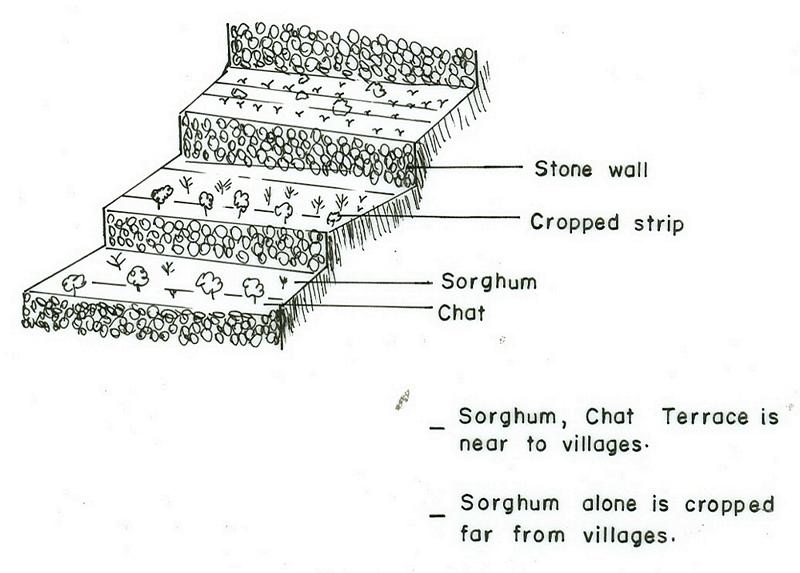
Technical specifications (related to technical drawing):
DireDawa
Technical knowledge required for field staff / advisors: moderate
Technical knowledge required for land users: moderate
Main technical functions: reduction of slope angle, increase of infiltration, increase / maintain water stored in soil
Secondary technical functions: water harvesting / increase water supply, sediment retention / trapping, sediment harvesting
Early planting
Material/ species: Sorghum + Chat
Quantity/ density: 17500 +400
Mixed cropping / intercropping
Material/ species: Sorghum + Potato
Contour planting / strip cropping
Material/ species: Sorghum + Chat
Mulching
Material/ species: Sorghu Stalk/residue
Green manure
Material/ species: Sorghum/Chat-beans
Manure / compost / residues
Material/ species: Sorghum/Chat
Contour tillage
Remarks: Ploughing along the contour
Aligned: -contour
Vegetative material: O : other
Number of plants per (ha): 17500-2000
Spacing between rows / strips / blocks (m): 0.2
Vertical interval within rows / strips / blocks (m): 0.2-0.3
Perennial crops species: Chat
Slope (which determines the spacing indicated above): 10.00%
If the original slope has changed as a result of the Technology, the slope today is (see figure below): 3.00%
Gradient along the rows / strips: 0.00%
Terrace: backward sloping
Vertical interval between structures (m): 1-2
Spacing between structures (m): 4-6
Height of bunds/banks/others (m): 1
Width of bunds/banks/others (m): 0.5-2
Length of bunds/banks/others (m): 50-300
Bund/ bank: level
Vertical interval between structures (m): 1-2
Height of bunds/banks/others (m): 1
Width of bunds/banks/others (m): 0.3-0.5
Length of bunds/banks/others (m): 50-300
Construction material (earth): earth is placed upslope of the stone wall to provide reinforcement
Construction material (stone): stone is used for the embankment
Slope (which determines the spacing indicated above): 12%
If the original slope has changed as a result of the Technology, the slope today is: 4%
Lateral gradient along the structure: 0%
Vegetation is used for stabilisation of structures.
Change of land use type: from grazing to cultivated land
Control / change of species composition: from mono-cropping to mixed cropping
4.2 General information regarding the calculation of inputs and costs
other/ national currency (specify):
Birr
If relevant, indicate exchange rate from USD to local currency (e.g. 1 USD = 79.9 Brazilian Real): 1 USD =:
8.6
Indicate average wage cost of hired labour per day:
0.71
4.3 Establishment activities
| Activity | Timing (season) | |
|---|---|---|
| 1. | Chat planting by cutting | early rains |
| 2. | Sorghum planting | early rains |
| 3. | Sowing | with rains & withdrawal of rains |
| 4. | Contour marking & layout | dry period/after harvest |
| 5. | Digging foundation | after light rains/moist soil |
| 6. | Stone collection | dry season |
| 7. | Stone wall placement | after light rains/moist soil |
| 8. | Earth support upslope | after light rains/moist soil |
| 9. | Clear vegetation | dry period |
| 10. | Construct Daga | dry season |
| 11. | Land preparation | after the 1st rains |
4.4 Costs and inputs needed for establishment
| Specify input | Unit | Quantity | Costs per Unit | Total costs per input | % of costs borne by land users | |
|---|---|---|---|---|---|---|
| Labour | Labour | ha | 1.0 | 272.0 | 272.0 | 50.0 |
| Equipment | Animal traction | ha | 1.0 | 20.0 | 20.0 | 100.0 |
| Equipment | Tools | ha | 1.0 | 4.0 | 4.0 | 100.0 |
| Plant material | Seeds | ha | 1.0 | 5.0 | 5.0 | 100.0 |
| Fertilizers and biocides | Compost manure | ha | 1.0 | 100.0 | ||
| Total costs for establishment of the Technology | 301.0 | |||||
| Total costs for establishment of the Technology in USD | 35.0 | |||||
Comments:
Duration of establishment phase: 12 month(s)
4.5 Maintenance/ recurrent activities
| Activity | Timing/ frequency | |
|---|---|---|
| 1. | Tillage | dry season / 2-3 |
| 2. | Sowing | dry season / each cropping season |
| 3. | Cultivation | early rains, after sawing, before flowering / each cropping season |
| 4. | Weeding | after flowrinf / each cropping season |
| 5. | Harvest | dry season, after crop matures / each cropping season |
| 6. | Cultivation | during rains /2 |
| 7. | Weeding | withdrawal of rains /1 |
| 8. | Stone collection | dry season/1 |
| 9. | Repairing breaks | before planting/1 |
| 10. | Add stone wall height/upgrading | before planting/1 |
| 11. | Plant stablizing/ trees/shrubs | after rains/1 |
| 12. | Planting of useful trees & fruit trees | after rains / annual |
| 13. | Cultivation and weeding | during rains / 2 |
4.6 Costs and inputs needed for maintenance/ recurrent activities (per year)
| Specify input | Unit | Quantity | Costs per Unit | Total costs per input | % of costs borne by land users | |
|---|---|---|---|---|---|---|
| Labour | Labour | ha | 1.0 | 40.7 | 40.7 | 100.0 |
| Total costs for maintenance of the Technology | 40.7 | |||||
| Total costs for maintenance of the Technology in USD | 4.73 | |||||
Comments:
Machinery/ tools: hand tools for digging earth and breaking stone
The cost is mainly for construction and maintenance of the structural measures and cost of production.
4.7 Most important factors affecting the costs
Describe the most determinate factors affecting the costs:
Slope:- As the slope increases cost of construction increases, Soil depth:- when the soil depth is shallow digging the foundation becomes more costly.
5. Natural and human environment
5.1 Climate
Annual rainfall
- < 250 mm
- 251-500 mm
- 501-750 mm
- 751-1,000 mm
- 1,001-1,500 mm
- 1,501-2,000 mm
- 2,001-3,000 mm
- 3,001-4,000 mm
- > 4,000 mm
Specify average annual rainfall (if known), in mm:
600.00
Agro-climatic zone
- semi-arid
5.2 Topography
Slopes on average:
- flat (0-2%)
- gentle (3-5%)
- moderate (6-10%)
- rolling (11-15%)
- hilly (16-30%)
- steep (31-60%)
- very steep (>60%)
Landforms:
- plateau/plains
- ridges
- mountain slopes
- hill slopes
- footslopes
- valley floors
Altitudinal zone:
- 0-100 m a.s.l.
- 101-500 m a.s.l.
- 501-1,000 m a.s.l.
- 1,001-1,500 m a.s.l.
- 1,501-2,000 m a.s.l.
- 2,001-2,500 m a.s.l.
- 2,501-3,000 m a.s.l.
- 3,001-4,000 m a.s.l.
- > 4,000 m a.s.l.
Comments and further specifications on topography:
Landforms: Also hill slopes (ranked 2) and valley floors (ranked 3)
Slopes on average: Also hilly (ranked 2) and moderate as well as gentle (both ranked 3)
5.3 Soils
Soil depth on average:
- very shallow (0-20 cm)
- shallow (21-50 cm)
- moderately deep (51-80 cm)
- deep (81-120 cm)
- very deep (> 120 cm)
Soil texture (topsoil):
- coarse/ light (sandy)
- medium (loamy, silty)
Topsoil organic matter:
- low (<1%)
If available, attach full soil description or specify the available information, e.g. soil type, soil PH/ acidity, Cation Exchange Capacity, nitrogen, salinity etc.
Soil fertility is low (ranked 1), medium (ranked 2) and very low (ranked 3)
Soil drainage/infiltration is good
Soil water storage capacity is low (ranked 1), medium (ranked 2) and very low (ranked 3)
5.6 Characteristics of land users applying the Technology
Market orientation of production system:
- subsistence (self-supply)
- mixed (subsistence/ commercial)
Off-farm income:
- less than 10% of all income
Relative level of wealth:
- poor
- average
Level of mechanization:
- manual work
- animal traction
Indicate other relevant characteristics of the land users:
Population density: 50-100 persons/km2
Annual population growth: 2% - 3%
40% of the land users are average wealthy and own 60% of the land.
60% of the land users are poor and own 40% of the land.
Off-farm income specification: Land users who have SWC on their land spend more time in agricultural activities compared to those who have not applied SWC measures.
Level of mechanization: Manual work (ranked 1, on steeper slopes where terraces are closer manual labour is used) and animal traction (ranked 2, on gentle slopes animal traction is used for tillage and cultivation)
Market orientation of cropland production system: Subsistence ( They do not produce enough for their own consumption in case of sorghum/cereal crops but chat is produced more for market, ranked 1) and mixed (ranked 2)
Market orientation of forest production system: Subsistence (Chat is planted for consumption as well as market, ranked 1) and mixed (Farmers sell part of the grain they have produced)
Market orientation of production system: mixed (subsistence and commercial) (Farmers sell part of the grain they have produced.)
5.7 Average area of land used by land users applying the Technology
- < 0.5 ha
- 0.5-1 ha
- 1-2 ha
- 2-5 ha
- 5-15 ha
- 15-50 ha
- 50-100 ha
- 100-500 ha
- 500-1,000 ha
- 1,000-10,000 ha
- > 10,000 ha
Comments:
Most of the open access grazing land and degraded hills where animal graze is communal land.
6. Impacts and concluding statements
6.1 On-site impacts the Technology has shown
Socio-economic impacts
Production
crop production
Comments/ specify:
Because of high moisture in the soil
fodder production
Comments/ specify:
multipurpose tree species with good production potential are planted.
fodder quality
Comments/ specify:
multipurpose tree species with good production potential are planted.
production area
Comments/ specify:
due to structures occupying land
land management
Comments/ specify:
due to structural obstraction
Income and costs
farm income
Socio-cultural impacts
community institutions
national institutions
conflict mitigation
Ecological impacts
Water cycle/ runoff
surface runoff
Quantity before SLM:
50
Quantity after SLM:
0
Soil
soil moisture
soil loss
Quantity before SLM:
100
Quantity after SLM:
5
Other ecological impacts
Soil fertility
6.2 Off-site impacts the Technology has shown
downstream flooding
downstream siltation
6.4 Cost-benefit analysis
How do the benefits compare with the establishment costs (from land users’ perspective)?
Short-term returns:
slightly negative
Long-term returns:
slightly positive
How do the benefits compare with the maintenance/ recurrent costs (from land users' perspective)?
Short-term returns:
neutral/ balanced
Long-term returns:
very positive
6.5 Adoption of the Technology
Of all those who have adopted the Technology, how many did so spontaneously, i.e. without receiving any material incentives/ payments?
- 11-50%
Comments:
30% of land user families have adopted the Technology with external material support
20% of land user families have adopted the Technology without any external material support
6.7 Strengths/ advantages/ opportunities of the Technology
| Strengths/ advantages/ opportunities in the land user’s view |
|---|
|
Production increased How can they be sustained / enhanced? external support with incentives such as tools, material for constructing structures for flood and runoff diversion. |
|
more soil moisture How can they be sustained / enhanced? integration of measures that reduces evapotranspiration |
|
Soil erosion controlled How can they be sustained / enhanced? exercise effective maintenance |
| Strengths/ advantages/ opportunities in the compiler’s or other key resource person’s view |
|---|
|
have higher efficiency for retaining water in the soil How can they be sustained / enhanced? Strengthening maintenance, avoid livestock,exercise stall feeding, enhancing runoff and flood farming |
| mantenance is simple because material is available |
| Forms bench terrace easily |
| Soil loss is remarkably reduced |
| Production doubled and even increased by 150-200% |
6.8 Weaknesses/ disadvantages/ risks of the Technology and ways of overcoming them
| Weaknesses/ disadvantages/ risks in the compiler’s or other key resource person’s view | How can they be overcome? |
|---|---|
| hindering movement | provide path way for humans and oxen during farm operation |
7. References and links
7.1 Methods/ sources of information
Links and modules
Expand all Collapse allLinks
No links
Modules
No modules