Taungya systems for forest management [Tanzania, United Republic of]
- Creation:
- Update:
- Compiler: Philip Ileta
- Editor: –
- Reviewers: David Streiff, Alexandra Gavilano
Kilimo cha miti na mazao ya msimu (Swahili), Intercropping trees with annual crops
technologies_1156 - Tanzania, United Republic of
View sections
Expand all Collapse all1. General information
1.2 Contact details of resource persons and institutions involved in the assessment and documentation of the Technology
SLM specialist:
Mugishagwe Wilson
Ngara District Council
Tanzania, United Republic of
SLM specialist:
Waluce Michael
Ngara District Council
Tanzania, United Republic of
SLM specialist:
Sangatati Joesephat
Ngara District Council
Tanzania, United Republic of
SLM specialist:
Waziri Zawadi
Ngara District Council
Tanzania, United Republic of
Name of the institution(s) which facilitated the documentation/ evaluation of the Technology (if relevant)
Ngara District Council (Ngara District Council) - Tanzania, United Republic of1.3 Conditions regarding the use of data documented through WOCAT
The compiler and key resource person(s) accept the conditions regarding the use of data documented through WOCAT:
Yes
1.4 Declaration on sustainability of the described Technology
Is the Technology described here problematic with regard to land degradation, so that it cannot be declared a sustainable land management technology?
No
2. Description of the SLM Technology
2.1 Short description of the Technology
Definition of the Technology:
A forest management system whereby trees are inter-cropped with annual crops until when the crops below can no longer flourish due to the dense canopy of trees.
2.2 Detailed description of the Technology
Description:
The overall purpose is to establish and manage forest in a sustainable manner. Land preparation is done during the dry season. Prepared seedling is planted at the beginning of the rainy season at recommended spacing. The area between trees is intercropped with selected annual crops. The crops can continue to be grown until the tree canopy covers the ground (3 to 4 years period). At this stage the system does not support intercropping and the trees are left to grow on their own. The Taungya technology is applied on degraded forest or a new established forest. Recomended supportive technologies are contours for erosion control and manure application for soil quality improvement.
Purpose of the Technology: A well established and managed forest/woodlot ensured in the degraded forest by:
-Intercropping with selected annual crops to improve soil cover, water infiltration, soil organic matter, reduce soil erosion and water evaporation.
-To conduct multiple tending operations for the tree plots and crops (weeding,firebreaks,pruning and thinning)thus minimizing the costs and maximizing returns
-Increased productivity and production through diversification strategies.
-Enhance food security and income.
Establishment / maintenance activities and inputs: -Land preparation during dry season (June to Sept).
-(Allignment,marking and pitting for tree seedlings (Oct-Nov)
-Planting of trees(Nov-Dec)
-Planting of crops (Oct-Nov)
-Weeding
-Harvesting crops
Natural / human environment: Fire threats during dry season, Termite attacks to trees, High costs for labour to perform tending activities in large forest plots
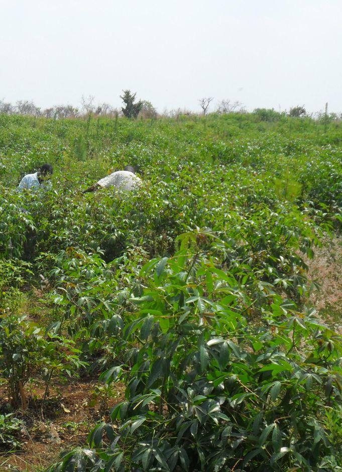
2.3 Photos of the Technology
Media Gallery
2.5 Country/ region/ locations where the Technology has been applied and which are covered by this assessment
Country:
Tanzania, United Republic of
Region/ State/ Province:
Kagera
Further specification of location:
Ngara
Specify the spread of the Technology:
- evenly spread over an area
If precise area is not known, indicate approximate area covered:
- 0.1-1 km2
Comments:
Total area covered by the SLM Technology is <0.1 km2.
The plantation is planted mainly with Pinus caribaea and few compartments Maesopsis eminii of 3 years and intercropped with cassava,gnuts and beans,well weeded and firebreaks established. The plantation covers 32 hectares.
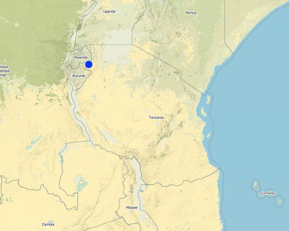
Map
×2.6 Date of implementation
If precise year is not known, indicate approximate date:
- less than 10 years ago (recently)
2.7 Introduction of the Technology
Specify how the Technology was introduced:
- through projects/ external interventions
Comments (type of project, etc.):
Various projects of afforestation have been active in the area before and during the Refugee influx from Rwanda and Burundi 1994-2007
3. Classification of the SLM Technology
3.1 Main purpose(s) of the Technology
- conserve ecosystem
- preserve/ improve biodiversity
3.2 Current land use type(s) where the Technology is applied
Land use mixed within the same land unit:
Yes
Specify mixed land use (crops/ grazing/ trees):
- Agroforestry

Cropland
- Annual cropping
Annual cropping - Specify crops:
- legumes and pulses - beans
- root/tuber crops - cassava
- gnuts
Number of growing seasons per year:
- 2
Specify:
Longest growing period in days: 120; Longest growing period from month to month: Oct to Dec; Second longest growing period in days: 90; Second longest growing period from month to month: March to May

Forest/ woodlands
- Tree plantation, afforestation
Tree plantation, afforestation: Specify origin and composition of species:
- Mixed varieties
- timber trees
Products and services:
- Timber
- Fuelwood
- Grazing/ browsing
Comments:
Major land use problems (compiler’s opinion): High fire incidences during dry seasons, Red clay loam soils harden and dry easily during dry spells, Forest are usually long term investments,thus high costs of inputs before harvests
Major land use problems (land users’ perception): High fire incidences during dry seasons, High costs for weeding and slashing
Problems / comments regarding forest use: Softwood plantation
Future (final) land use (after implementation of SLM Technology): Forests / woodlands: Fp: Plantations, afforestations
3.4 Water supply
Water supply for the land on which the Technology is applied:
- rainfed
3.5 SLM group to which the Technology belongs
- natural and semi-natural forest management
- agroforestry
3.6 SLM measures comprising the Technology

agronomic measures
- A3: Soil surface treatment

vegetative measures
- V3: Clearing of vegetation

management measures
- M2: Change of management/ intensity level
3.7 Main types of land degradation addressed by the Technology

physical soil deterioration
- Pk: slaking and crusting
- Pi: soil sealing
Comments:
Main causes of degradation: deforestation / removal of natural vegetation (incl. forest fires), change in temperature (Fires become more aggresive in hot dry season)
Secondary causes of degradation: soil management (To enhance infiltration of water to hard subsoil), over-exploitation of vegetation for domestic use (Acute shortage of fuelwood in the area)
3.8 Prevention, reduction, or restoration of land degradation
Specify the goal of the Technology with regard to land degradation:
- prevent land degradation
4. Technical specifications, implementation activities, inputs, and costs
4.1 Technical drawing of the Technology
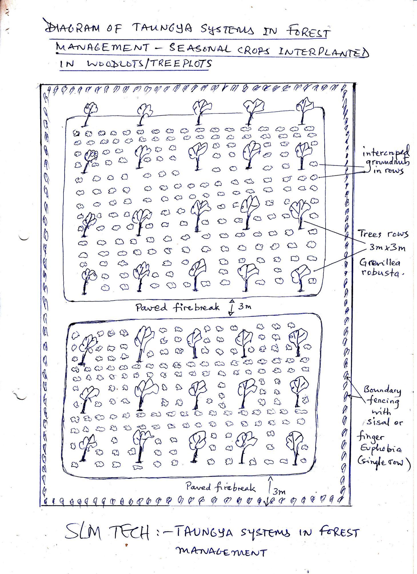
Technical specifications (related to technical drawing):
Diagram of Taungya system in forest management -seasonal crop inter planted in woodlots/tree plots.
Location: Rusumo village. Ngara District Council/Kagera/ Tanzania
Date: 15 May 2013
Technical knowledge required for field staff / advisors: moderate (Experience in agroforestry extension is usually enough to assist farmers)
Technical knowledge required for land users: moderate (A number of manuals provide guidance on afforestation projects)
Main technical functions: reduction of dry material (fuel for wildfires)
Secondary technical functions: improvement of surface structure (crusting, sealing), control of fires
Mixed cropping / intercropping
Material/ species: cassava cuttings
Quantity/ density: 500/ha
Remarks: between tree rows
Cover cropping
Material/ species: beans
Remarks: between tree rows
Retaining more vegetation cover
Material/ species: Plant tree seedlings
Quantity/ density: 1700/ha
Remarks: Line planting 2.5mx2.5m
Manure / compost / residues
Material/ species: crop residues in repeated seasond
Remarks: remain to decay in tree plots
Breaking crust / sealed surface
Material/ species: thorough land cultivation using hand hoes
Remarks: during initial land preparation
Breaking compacted topsoil
Material/ species: continuous cultivation and weeding -hoes
Remarks: enhance water infiltration
Aligned: -linear
Number of plants per (ha): 1700
Vertical interval between rows / strips / blocks (m): 2.5
Spacing between rows / strips / blocks (m): 2.5
Vertical interval within rows / strips / blocks (m): 2.5
Width within rows / strips / blocks (m): 2.5
Trees/ shrubs species: Pinus caribaea
Perennial crops species: cassava
Gradient along the rows / strips: 8%
Change of land use type: convertion of rweya(uncultivated grassland) to woodlot/forest plantation
Change of land use practices / intensity level: Perform agronomy practices for crops,sivicultural practices for trees
Layout change according to natural and human environment: increseased soil cover due to many planted trees and agricultural crops
Major change in timing of activities: plant trees at the start of long rains to maximise survival rates
Control / change of species composition: indigineous trees highly deforested, replaced with planted forest of high cormecial value
Other type of management: Establishing firelines/roads each year enables easy prevention/controll of wild fires.
Author:
Ileta Philip, P.O BOX 30 Ngara
4.2 General information regarding the calculation of inputs and costs
other/ national currency (specify):
Tanzania shilling
If relevant, indicate exchange rate from USD to local currency (e.g. 1 USD = 79.9 Brazilian Real): 1 USD =:
1600.0
Indicate average wage cost of hired labour per day:
1.25
4.3 Establishment activities
| Activity | Timing (season) | |
|---|---|---|
| 1. | Allign and screef 3m wide roads around tree plot and between compartments | before dry season |
4.4 Costs and inputs needed for establishment
| Specify input | Unit | Quantity | Costs per Unit | Total costs per input | % of costs borne by land users | |
|---|---|---|---|---|---|---|
| Labour | Allign and screef 3m wide roads around tree plot | persons/day/ha | 200.0 | 2000.0 | 400000.0 | 100.0 |
| Equipment | Hoes, machetes and axes | pieces | 10.0 | 6000.0 | 60000.0 | 100.0 |
| Plant material | Tree seedlings | pieces | 1700.0 | 200.0 | 340000.0 | 50.0 |
| Plant material | Cassava cuttings | pieces | 5000.0 | 20.0 | 100000.0 | 100.0 |
| Plant material | Beans | kg | 25.0 | 500.0 | 12500.0 | 100.0 |
| Total costs for establishment of the Technology | 912500.0 | |||||
| Total costs for establishment of the Technology in USD | 570.31 | |||||
4.5 Maintenance/ recurrent activities
| Activity | Timing/ frequency | |
|---|---|---|
| 1. | Weeding | routine twice sesonally |
| 2. | Slashing and screefing firebreaks | once yearly |
| 3. | Prunning excess tree branches | every 3 yrs |
| 4. | Slashing short grass and screef firebreak roads | once yearly |
4.6 Costs and inputs needed for maintenance/ recurrent activities (per year)
| Specify input | Unit | Quantity | Costs per Unit | Total costs per input | % of costs borne by land users | |
|---|---|---|---|---|---|---|
| Labour | Weeding | persons/day/ha | 100.0 | 2000.0 | 200000.0 | 100.0 |
| Labour | Slashing and screefing firebreaks | persons/day/ha | 50.0 | 2000.0 | 100000.0 | 100.0 |
| Labour | Prunning excess tree branches | persons/day/ha | 5.0 | 4000.0 | 20000.0 | 100.0 |
| Labour | Slashing short grass and screef firebreak roads | persons/day/ha | 10.0 | 2000.0 | 20000.0 | 100.0 |
| Total costs for maintenance of the Technology | 340000.0 | |||||
| Total costs for maintenance of the Technology in USD | 212.5 | |||||
Comments:
Machinery/ tools: hoes, matchets, axes, slashers, handsaws, per hectare year (2012)
4.7 Most important factors affecting the costs
Describe the most determinate factors affecting the costs:
high labour especially during establishment and repeated tending of crops and trees
5. Natural and human environment
5.1 Climate
Annual rainfall
- < 250 mm
- 251-500 mm
- 501-750 mm
- 751-1,000 mm
- 1,001-1,500 mm
- 1,501-2,000 mm
- 2,001-3,000 mm
- 3,001-4,000 mm
- > 4,000 mm
Agro-climatic zone
- sub-humid
Thermal climate class: tropics
5.2 Topography
Slopes on average:
- flat (0-2%)
- gentle (3-5%)
- moderate (6-10%)
- rolling (11-15%)
- hilly (16-30%)
- steep (31-60%)
- very steep (>60%)
Landforms:
- plateau/plains
- ridges
- mountain slopes
- hill slopes
- footslopes
- valley floors
Altitudinal zone:
- 0-100 m a.s.l.
- 101-500 m a.s.l.
- 501-1,000 m a.s.l.
- 1,001-1,500 m a.s.l.
- 1,501-2,000 m a.s.l.
- 2,001-2,500 m a.s.l.
- 2,501-3,000 m a.s.l.
- 3,001-4,000 m a.s.l.
- > 4,000 m a.s.l.
5.3 Soils
Soil depth on average:
- very shallow (0-20 cm)
- shallow (21-50 cm)
- moderately deep (51-80 cm)
- deep (81-120 cm)
- very deep (> 120 cm)
Soil texture (topsoil):
- medium (loamy, silty)
Topsoil organic matter:
- high (>3%)
- medium (1-3%)
If available, attach full soil description or specify the available information, e.g. soil type, soil PH/ acidity, Cation Exchange Capacity, nitrogen, salinity etc.
Soil fertility is medium - high
5.4 Water availability and quality
Ground water table:
> 50 m
Availability of surface water:
medium
Water quality (untreated):
for agricultural use only (irrigation)
Comments and further specifications on water quality and quantity:
Ground water table: The plot is on top of the plateau/ridge
Availability of surface water: Is good when further away, because the permanent rivers Kagera and Ruvuvu are 2km below the plateau.
Water quality (untreated): Good because a gravity scheme supplies water to nearby areas 2kms, but for agriculture only because seasonal agriculture in the dry season in wetlands along the rivers.
5.6 Characteristics of land users applying the Technology
Market orientation of production system:
- mixed (subsistence/ commercial)
- commercial/ market
Off-farm income:
- > 50% of all income
Relative level of wealth:
- average
- rich
Individuals or groups:
- individual/ household
Level of mechanization:
- manual work
Gender:
- men
Indicate other relevant characteristics of the land users:
Land users applying the Technology are mainly common / average land users
Difference in the involvement of women and men: labour works performed well by both men and women
Population density: 10-50 persons/km2
Annual population growth: 2% - 3%
10% of the land users are rich and own 30% of the land.
20% of the land users are average wealthy and own 40% of the land.
Off-farm income specification: The land user is a businessman and have good number of cattle,however there are many other tree plots in the village owned by other farmers
5.7 Average area of land used by land users applying the Technology
- < 0.5 ha
- 0.5-1 ha
- 1-2 ha
- 2-5 ha
- 5-15 ha
- 15-50 ha
- 50-100 ha
- 100-500 ha
- 500-1,000 ha
- 1,000-10,000 ha
- > 10,000 ha
Is this considered small-, medium- or large-scale (referring to local context)?
- medium-scale
Comments:
0.5-1 ha: Farmers in the village have many eucalyptus tree plots for firewood and poles,but now opening new land for planting pines Agroforestry practices widespread in banana cropping system in the village
15-50 ha for cropland
5.8 Land ownership, land use rights, and water use rights
Land ownership:
- individual, not titled
Land use rights:
- individual
Water use rights:
- individual
Comments:
water free for agricultural use,minimum payments for domestic use
5.9 Access to services and infrastructure
health:
- poor
- moderate
- good
education:
- poor
- moderate
- good
technical assistance:
- poor
- moderate
- good
markets:
- poor
- moderate
- good
energy:
- poor
- moderate
- good
roads and transport:
- poor
- moderate
- good
drinking water and sanitation:
- poor
- moderate
- good
financial services:
- poor
- moderate
- good
6. Impacts and concluding statements
6.1 On-site impacts the Technology has shown
Socio-economic impacts
Production
crop production
Comments/ specify:
Harvesting of crops
wood production
Comments/ specify:
At rotation age 15-20 yrs
Income and costs
expenses on agricultural inputs
Comments/ specify:
Multiple tending operations (crops and trees)
Other socio-economic impacts
liv
Socio-cultural impacts
food security/ self-sufficiency
livelihood and human well-being
Comments/ specify:
Increased income from agriculture crop sales improve food security availability of forest products decreased workload mainly for women-branches of trees and thinnings for firewood
Ecological impacts
Soil
soil cover
soil crusting/ sealing
Biodiversity: vegetation, animals
biomass/ above ground C
Climate and disaster risk reduction
fire risk
6.2 Off-site impacts the Technology has shown
damage on neighbours' fields
Comments/ specify:
As windbreaks
6.3 Exposure and sensitivity of the Technology to gradual climate change and climate-related extremes/ disasters (as perceived by land users)
Gradual climate change
Gradual climate change
| Season | increase or decrease | How does the Technology cope with it? | |
|---|---|---|---|
| annual temperature | increase | not well |
Climate-related extremes (disasters)
Climatological disasters
| How does the Technology cope with it? | |
|---|---|
| drought | not well |
Comments:
The control of fires can be improved by boundary planting of fire tolerant plant species e.g sisal(Agaves sisalana),euphobia spp etc
6.4 Cost-benefit analysis
How do the benefits compare with the establishment costs (from land users’ perspective)?
Short-term returns:
positive
Long-term returns:
positive
How do the benefits compare with the maintenance/ recurrent costs (from land users' perspective)?
Short-term returns:
slightly negative
Long-term returns:
positive
Comments:
Benefits from timber harvest from18 yrs and above,but can harvest for pulp at 8yrs,short term benefits from trees include thinnings for firewood short term from crop sales, decreased input costs due to multiple tending
6.5 Adoption of the Technology
- > 50%
If available, quantify (no. of households and/ or area covered):
24 households covering 100 percent of stated area
Of all those who have adopted the Technology, how many did so spontaneously, i.e. without receiving any material incentives/ payments?
- 51-90%
Comments:
4 land user families have adopted the Technology with external material support
20 land user families have adopted the Technology without any external material support
Comments on spontaneous adoption: The planting of pine and intercropping with cassava,gnuts and beans has been adopted by many farmers due to the anticipation of carbon trading in future and expansion of cormecial forestry
There is a strong trend towards spontaneous adoption of the Technology
Comments on adoption trend: Large ares of land in Rusumo are still uncultivated/no settlements and many farmers have opted to establish woodlots of pines-as highly paying project in future with posibilities for accessing bank loans
6.7 Strengths/ advantages/ opportunities of the Technology
| Strengths/ advantages/ opportunities in the land user’s view |
|---|
| Increased incomes |
| Diversified food crops |
| Fire outbreak prevention/control |
| Strengths/ advantages/ opportunities in the compiler’s or other key resource person’s view |
|---|
| Production of timber and firewood |
| Enhanced food security |
| Prevention of fire to damage trees/crops |
| Reduce soil erosion-improved soil cover |
| Improved carbon sequestration |
6.8 Weaknesses/ disadvantages/ risks of the Technology and ways of overcoming them
| Weaknesses/ disadvantages/ risks in the land user’s view | How can they be overcome? |
|---|---|
| High labour costs | grow food crops for 3-4 yrs |
| Shading increases and can no longer support crops | seek advise from agriculture/forestry depts prunnings, thinning on time |
| Weaknesses/ disadvantages/ risks in the compiler’s or other key resource person’s view | How can they be overcome? |
|---|---|
| High labour costs | in places with shortage of lands renting farm plots |
| Difficult to use machines in tending,weeding etc | Timely prunning and thinning regimes |
| Shading increses and can no longer support crops | Keep dogs and seek support from Game control department |
| Can be hiding place for vermin |
7. References and links
7.1 Methods/ sources of information
- field visits, field surveys
- interviews with land users
When were the data compiled (in the field)?
12/12/2011
Links and modules
Expand all Collapse allLinks
No links
Modules
No modules