Taungya systems for forest management [แทนซาเนีย]
- ผู้สร้างสรรค์:
- การอัพเดท:
- ผู้รวบรวม: Philip Ileta
- ผู้เรียบเรียง: –
- ผู้ตรวจสอบ: David Streiff, Alexandra Gavilano
Kilimo cha miti na mazao ya msimu (Swahili), Intercropping trees with annual crops
technologies_1156 - แทนซาเนีย
ดูส่วนย่อย
ขยายทั้งหมด ย่อทั้งหมด1. ข้อมูลทั่วไป
1.2 รายละเอียดที่ติดต่อได้ของผู้รวบรวมและองค์กรที่เกี่ยวข้องในการประเมินและการจัดเตรียมทำเอกสารของเทคโนโลยี
ผู้เชี่ยวชาญ SLM:
Mugishagwe Wilson
Ngara District Council
แทนซาเนีย
ผู้เชี่ยวชาญ SLM:
Waluce Michael
Ngara District Council
แทนซาเนีย
ผู้เชี่ยวชาญ SLM:
Sangatati Joesephat
Ngara District Council
แทนซาเนีย
ผู้เชี่ยวชาญ SLM:
Waziri Zawadi
Ngara District Council
แทนซาเนีย
ชื่อขององค์กรซึ่งอำนวยความสะดวกในการทำเอกสารหรือการประเมินเทคโนโลยี (ถ้าเกี่ยวข้อง)
Ngara District Council (Ngara District Council) - แทนซาเนีย1.3 เงื่อนไขการใช้ข้อมูลที่ได้บันทึกผ่านทาง WOCAT
ผู้รวบรวมและวิทยากรหลักยอมรับเงื่อนไขเกี่ยวกับการใช้ข้อมูลที่ถูกบันทึกผ่านทาง WOCAT:
ใช่
1.4 การเปิดเผยเรื่องความยั่งยืนของเทคโนโลยีที่ได้อธิบายไว้
เทคโนโลยีที่ได้อธิบายไว้นี้เป็นปัญหาของความเสื่อมโทรมโทรมของที่ดินหรือไม่ จึงไม่ได้รับการยอมรับว่าเป็นเทคโนโลยีเพื่อการจัดการที่ดินอย่างยั่งยืน:
ไม่ใช่
2. การอธิบายลักษณะของเทคโนโลยี SLM
2.1 การอธิบายแบบสั้น ๆ ของเทคโนโลยี
คำจำกัดความของเทคโนโลยี:
A forest management system whereby trees are inter-cropped with annual crops until when the crops below can no longer flourish due to the dense canopy of trees.
2.2 การอธิบายแบบละเอียดของเทคโนโลยี
คำอธิบาย:
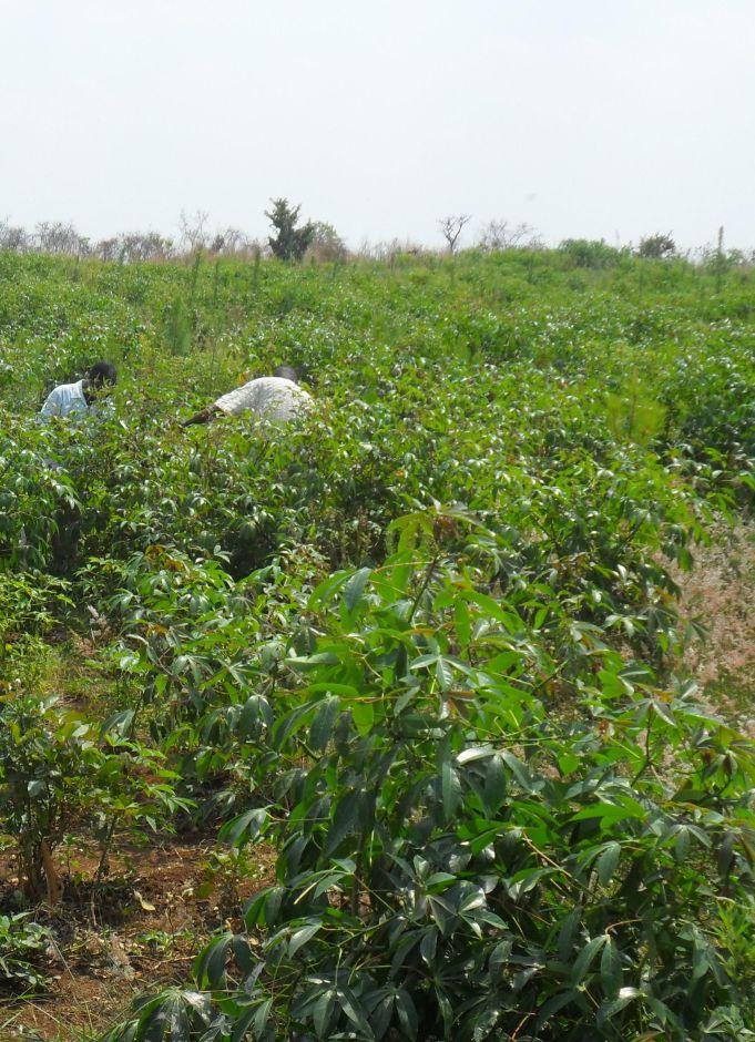
The overall purpose is to establish and manage forest in a sustainable manner. Land preparation is done during the dry season. Prepared seedling is planted at the beginning of the rainy season at recommended spacing. The area between trees is intercropped with selected annual crops. The crops can continue to be grown until the tree canopy covers the ground (3 to 4 years period). At this stage the system does not support intercropping and the trees are left to grow on their own. The Taungya technology is applied on degraded forest or a new established forest. Recomended supportive technologies are contours for erosion control and manure application for soil quality improvement.
Purpose of the Technology: A well established and managed forest/woodlot ensured in the degraded forest by:
-Intercropping with selected annual crops to improve soil cover, water infiltration, soil organic matter, reduce soil erosion and water evaporation.
-To conduct multiple tending operations for the tree plots and crops (weeding,firebreaks,pruning and thinning)thus minimizing the costs and maximizing returns
-Increased productivity and production through diversification strategies.
-Enhance food security and income.
Establishment / maintenance activities and inputs: -Land preparation during dry season (June to Sept).
-(Allignment,marking and pitting for tree seedlings (Oct-Nov)
-Planting of trees(Nov-Dec)
-Planting of crops (Oct-Nov)
-Weeding
-Harvesting crops
Natural / human environment: Fire threats during dry season, Termite attacks to trees, High costs for labour to perform tending activities in large forest plots
2.3 รูปภาพของเทคโนโลยี
อัลบั้มสื่อบันทึก
2.5 ประเทศภูมิภาค หรือสถานที่ตั้งที่เทคโนโลยีได้นำไปใช้และได้รับการครอบคลุมโดยการประเมินนี้
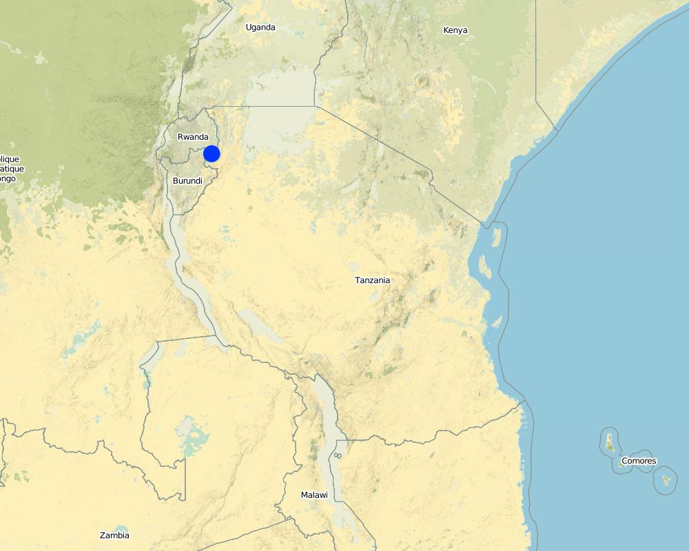
ประเทศ:
แทนซาเนีย
ภูมิภาค/รัฐ/จังหวัด:
Kagera
ข้อมูลจำเพาะเพิ่มเติมของสถานที่ตั้ง :
Ngara
ระบุการกระจายตัวของเทคโนโลยี:
- กระจายไปอย่างสม่ำเสมอในพื้นที่
If precise area is not known, indicate approximate area covered:
- 0.1-1 ตร.กม.
แสดงความคิดเห็น:
Total area covered by the SLM Technology is <0.1 km2.
The plantation is planted mainly with Pinus caribaea and few compartments Maesopsis eminii of 3 years and intercropped with cassava,gnuts and beans,well weeded and firebreaks established. The plantation covers 32 hectares.
Map
×2.6 วันที่การดำเนินการ
ถ้าไม่รู้ปีที่แน่นอน ให้ระบุวันที่โดยประมาณ:
- น้อยกว่า 10 ปี (ไม่นานนี้)
2.7 คำแนะนำของเทคโนโลยี
ให้ระบุว่าเทคโนโลยีถูกแนะนำเข้ามาอย่างไร:
- ทางโครงการหรือจากภายนอก
ความคิดเห็น (ประเภทของโครงการ เป็นต้น) :
Various projects of afforestation have been active in the area before and during the Refugee influx from Rwanda and Burundi 1994-2007
3. การจัดประเภทของเทคโนโลยี SLM
3.1 วัตถุประสงค์หลักของเทคโนโลยี
- อนุรักษ์ระบบนิเวศน์
- รักษาสภาพหรือปรับปรุงความหลากหลายทางชีวภาพ
3.2 ประเภทของการใช้ที่ดินในปัจจุบันที่ได้นำเทคโนโลยีไปใช้
Land use mixed within the same land unit:
ใช่
Specify mixed land use (crops/ grazing/ trees):
- วนเกษตร (Agroforestry)

พื้นที่ปลูกพืช
- การปลูกพืชล้มลุกอายุปีเดียว
Annual cropping - Specify crops:
- legumes and pulses - beans
- root/tuber crops - cassava
- gnuts
จำนวนของฤดูเพาะปลูกต่อปี:
- 2
ระบุ:
Longest growing period in days: 120; Longest growing period from month to month: Oct to Dec; Second longest growing period in days: 90; Second longest growing period from month to month: March to May

ป่า/พื้นที่ทำไม้
- ป่า/พื้นที่ทำไม้
Tree plantation, afforestation: Specify origin and composition of species:
- การปลูกหลายพันธุ์รวมกัน
- timber trees
ผลิตภัณฑ์และบริการ:
- ไม้ซุง
- ไม้ที่นำมาทำเป็นเชื้อเพลิง
- การแทะเล็มหญ้า / การเก็บกินหญ้า
แสดงความคิดเห็น:
Major land use problems (compiler’s opinion): High fire incidences during dry seasons, Red clay loam soils harden and dry easily during dry spells, Forest are usually long term investments,thus high costs of inputs before harvests
Major land use problems (land users’ perception): High fire incidences during dry seasons, High costs for weeding and slashing
Problems / comments regarding forest use: Softwood plantation
Future (final) land use (after implementation of SLM Technology): Forests / woodlands: Fp: Plantations, afforestations
3.4 การใช้น้ำ
การใช้น้ำของที่ดินที่มีการใช้เทคโนโลยีอยู่:
- จากน้ำฝน
3.5 กลุ่ม SLM ที่ตรงกับเทคโนโลยีนี้
- การจัดการป่าธรรมชาติและกึ่งธรรมชาติ
- การปลูกป่าร่วมกับพืช
3.6 มาตรการ SLM ที่ประกอบกันเป็นเทคโนโลยี

มาตรการจัดการพืช
- A3: การรักษาหน้าดิน

มาตรการอนุรักษ์ด้วยวิธีพืช
- V3: กำจัดพืชออกให้หมด

มาตรการอนุรักษ์ด้วยการจัดการ
- M2: การเปลี่ยนแปลงของการจัดการหรือระดับความเข้มข้น
3.7 รูปแบบหลักของการเสื่อมโทรมของที่ดินที่ได้รับการแก้ไขโดยเทคโนโลยี

การเสื่อมโทรมของดินทางด้านกายภาพ
- Pk (Slaking and crusting): การอุดตันของช่องว่างในดินหรือรูพรุน
- Pi (Soil sealing)
แสดงความคิดเห็น:
Main causes of degradation: deforestation / removal of natural vegetation (incl. forest fires), change in temperature (Fires become more aggresive in hot dry season)
Secondary causes of degradation: soil management (To enhance infiltration of water to hard subsoil), over-exploitation of vegetation for domestic use (Acute shortage of fuelwood in the area)
3.8 การป้องกัน การลดลง หรือการฟื้นฟูความเสื่อมโทรมของที่ดิน
ระบุเป้าหมายของเทคโนโลยีกับความเสื่อมโทรมของที่ดิน:
- ป้องกันความเสื่อมโทรมของที่ดิน
4. ข้อมูลจำเพาะด้านเทคนิค กิจกรรมการนำไปปฏิบัติใช้ ปัจจัยนำเข้า และค่าใช้จ่าย
4.1 แบบแปลนทางเทคนิคของเทคโนโลยี
ข้อมูลจำเพาะด้านเทคนิค (แบบแปลนทางเทคนิคของเทคโนโลยี):
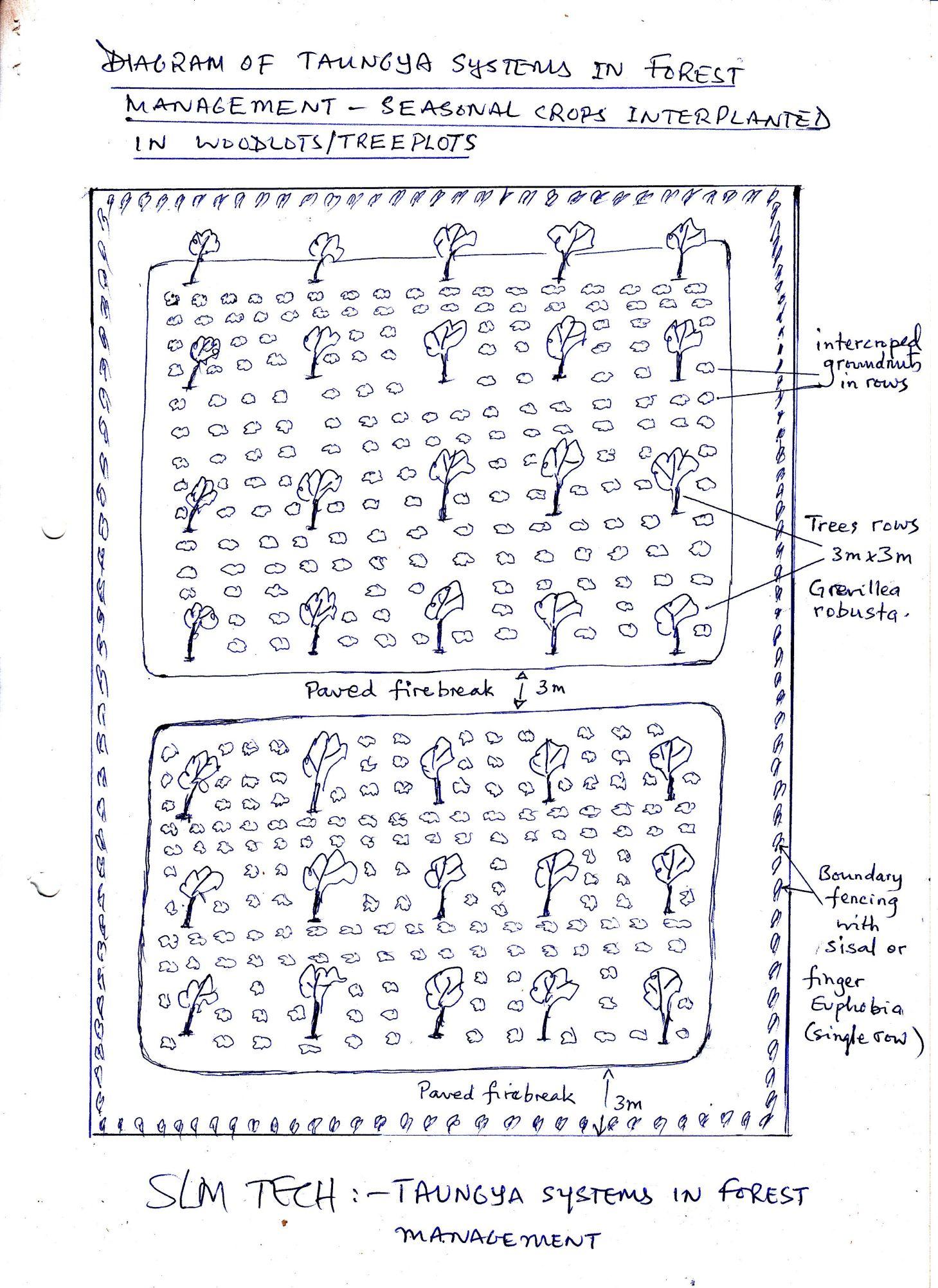
Diagram of Taungya system in forest management -seasonal crop inter planted in woodlots/tree plots.
Location: Rusumo village. Ngara District Council/Kagera/ Tanzania
Date: 15 May 2013
Technical knowledge required for field staff / advisors: moderate (Experience in agroforestry extension is usually enough to assist farmers)
Technical knowledge required for land users: moderate (A number of manuals provide guidance on afforestation projects)
Main technical functions: reduction of dry material (fuel for wildfires)
Secondary technical functions: improvement of surface structure (crusting, sealing), control of fires
Mixed cropping / intercropping
Material/ species: cassava cuttings
Quantity/ density: 500/ha
Remarks: between tree rows
Cover cropping
Material/ species: beans
Remarks: between tree rows
Retaining more vegetation cover
Material/ species: Plant tree seedlings
Quantity/ density: 1700/ha
Remarks: Line planting 2.5mx2.5m
Manure / compost / residues
Material/ species: crop residues in repeated seasond
Remarks: remain to decay in tree plots
Breaking crust / sealed surface
Material/ species: thorough land cultivation using hand hoes
Remarks: during initial land preparation
Breaking compacted topsoil
Material/ species: continuous cultivation and weeding -hoes
Remarks: enhance water infiltration
Aligned: -linear
Number of plants per (ha): 1700
Vertical interval between rows / strips / blocks (m): 2.5
Spacing between rows / strips / blocks (m): 2.5
Vertical interval within rows / strips / blocks (m): 2.5
Width within rows / strips / blocks (m): 2.5
Trees/ shrubs species: Pinus caribaea
Perennial crops species: cassava
Gradient along the rows / strips: 8%
Change of land use type: convertion of rweya(uncultivated grassland) to woodlot/forest plantation
Change of land use practices / intensity level: Perform agronomy practices for crops,sivicultural practices for trees
Layout change according to natural and human environment: increseased soil cover due to many planted trees and agricultural crops
Major change in timing of activities: plant trees at the start of long rains to maximise survival rates
Control / change of species composition: indigineous trees highly deforested, replaced with planted forest of high cormecial value
Other type of management: Establishing firelines/roads each year enables easy prevention/controll of wild fires.
ผู้เขียน:
Ileta Philip, P.O BOX 30 Ngara
4.2 ข้อมูลทั่วไปเกี่ยวกับการคำนวณปัจจัยนำเข้าและค่าใช้จ่าย
อื่นๆ หรือสกุลเงินประจำชาติ (ระบุ):
Tanzania shilling
If relevant, indicate exchange rate from USD to local currency (e.g. 1 USD = 79.9 Brazilian Real): 1 USD =:
1600.0
ระบุค่าเฉลี่ยของค่าจ้างในการจ้างแรงงานต่อวัน:
1.25
4.3 กิจกรรมเพื่อการจัดตั้ง
| กิจกรรม | Timing (season) | |
|---|---|---|
| 1. | Allign and screef 3m wide roads around tree plot and between compartments | before dry season |
4.4 ค่าใช้จ่ายของปัจจัยนำเข้าที่จำเป็นสำหรับการจัดตั้ง
| ปัจจัยนำเข้า | หน่วย | ปริมาณ | ค่าใช้จ่ายต่อหน่วย | ค่าใช้จ่ายทั้งหมดต่อปัจจัยนำเข้า | %ของค่าใช้จ่ายที่ก่อให้เกิดขึ้นโดยผู้ใช้ที่ดิน | |
|---|---|---|---|---|---|---|
| แรงงาน | Allign and screef 3m wide roads around tree plot | persons/day/ha | 200.0 | 2000.0 | 400000.0 | 100.0 |
| อุปกรณ์ | Hoes, machetes and axes | pieces | 10.0 | 6000.0 | 60000.0 | 100.0 |
| วัสดุด้านพืช | Tree seedlings | pieces | 1700.0 | 200.0 | 340000.0 | 50.0 |
| วัสดุด้านพืช | Cassava cuttings | pieces | 5000.0 | 20.0 | 100000.0 | 100.0 |
| วัสดุด้านพืช | Beans | kg | 25.0 | 500.0 | 12500.0 | 100.0 |
| ค่าใช้จ่ายทั้งหมดของการจัดตั้งเทคโนโลยี | 912500.0 | |||||
| Total costs for establishment of the Technology in USD | 570.31 | |||||
4.5 การบำรุงรักษาสภาพหรือกิจกรรมที่เกิดขึ้นเป็นประจำ
| กิจกรรม | ช่วงระยะเวลา/ความถี่ | |
|---|---|---|
| 1. | Weeding | routine twice sesonally |
| 2. | Slashing and screefing firebreaks | once yearly |
| 3. | Prunning excess tree branches | every 3 yrs |
| 4. | Slashing short grass and screef firebreak roads | once yearly |
4.6 ค่าใช้จ่ายของปัจจัยนำเข้าและกิจกรรมที่เกิดขึ้นเป็นประจำที่ต้องการการบำรุงรักษา (ต่อปี)
| ปัจจัยนำเข้า | หน่วย | ปริมาณ | ค่าใช้จ่ายต่อหน่วย | ค่าใช้จ่ายทั้งหมดต่อปัจจัยนำเข้า | %ของค่าใช้จ่ายที่ก่อให้เกิดขึ้นโดยผู้ใช้ที่ดิน | |
|---|---|---|---|---|---|---|
| แรงงาน | Weeding | persons/day/ha | 100.0 | 2000.0 | 200000.0 | 100.0 |
| แรงงาน | Slashing and screefing firebreaks | persons/day/ha | 50.0 | 2000.0 | 100000.0 | 100.0 |
| แรงงาน | Prunning excess tree branches | persons/day/ha | 5.0 | 4000.0 | 20000.0 | 100.0 |
| แรงงาน | Slashing short grass and screef firebreak roads | persons/day/ha | 10.0 | 2000.0 | 20000.0 | 100.0 |
| ค่าใช้จ่ายทั้งหมดของการบำรุงรักษาสภาพเทคโนโลยี | 340000.0 | |||||
| Total costs for maintenance of the Technology in USD | 212.5 | |||||
แสดงความคิดเห็น:
Machinery/ tools: hoes, matchets, axes, slashers, handsaws, per hectare year (2012)
4.7 ปัจจัยสำคัญที่สุดที่มีผลกระทบต่อค่าใช้จ่าย
ปัจจัยสำคัญที่สุดที่มีผลกระทบต่อค่าใช้จ่ายต่างๆ:
high labour especially during establishment and repeated tending of crops and trees
5. สิ่งแวดล้อมทางธรรมชาติและของมนุษย์
5.1 ภูมิอากาศ
ฝนประจำปี
- < 250 ม.ม.
- 251-500 ม.ม.
- 501-750 ม.ม.
- 751-1,000 ม.ม.
- 1,001-1,500 ม.ม.
- 1,501-2,000 ม.ม.
- 2,001-3,000 ม.ม.
- 3,001-4,000 ม.ม.
- > 4,000 ม.ม.
เขตภูมิอากาศเกษตร
- กึ่งชุ่มชื้น
Thermal climate class: tropics
5.2 สภาพภูมิประเทศ
ค่าเฉลี่ยความลาดชัน:
- ราบเรียบ (0-2%)
- ลาดที่ไม่ชัน (3-5%)
- ปานกลาง (6-10%)
- เป็นลูกคลื่น (11-15%)
- เป็นเนิน (16-30%)
- ชัน (31-60%)
- ชันมาก (>60%)
ธรณีสัณฐาน:
- ที่ราบสูง/ที่ราบ
- สันเขา
- ไหล่เขา
- ไหล่เนินเขา
- ตีนเนิน
- หุบเขา
ระดับความสูง:
- 0-100 เมตร
- 101-500 เมตร
- 501-1,000 เมตร
- 1,001-1,500 เมตร
- 1,501-2,000 เมตร
- 2,001-2,500 เมตร
- 2,501-3,000 เมตร
- 3,001-4,000 เมตร
- > 4,000 เมตร
5.3 ดิน
ค่าเฉลี่ยความลึกของดิน:
- ตื้นมาก (0-20 ซ.ม.)
- ตื้น (21-50 ซ.ม.)
- ลึกปานกลาง (51-80 ซ.ม.)
- ลึก (81-120 ซ.ม.)
- ลึกมาก (>120 ซ.ม.)
เนื้อดิน (ดินชั้นบน):
- ปานกลาง (ดินร่วน ทรายแป้ง)
อินทรียวัตถุในดิน:
- สูง (>3%)
- ปานกลาง (1-3%)
(ถ้ามี) ให้แนบคำอธิบายเรื่องดินแบบเต็มหรือระบุข้อมูลที่มีอยู่ เช่น ชนิดของดิน ค่า pH ของดินหรือความเป็นกรดของดิน ความสามารถในการแลกเปลี่ยนประจุบวก ไนโตรเจน ความเค็ม เป็นต้น:
Soil fertility is medium - high
5.4 ความเป็นประโยชน์และคุณภาพของน้ำ
ระดับน้ำใต้ดิน:
> 50 เมตร
น้ำไหลบ่าที่ผิวดิน:
ปานกลาง
คุณภาพน้ำ (ที่ยังไม่ได้บำบัด):
เป็นน้ำใช้เพื่อการเกษตรเท่านั้น (การชลประทาน)
ความคิดเห็นและข้อมูลจำเพาะเพิ่มเติมเรื่องคุณภาพและปริมาณน้ำ:
Ground water table: The plot is on top of the plateau/ridge
Availability of surface water: Is good when further away, because the permanent rivers Kagera and Ruvuvu are 2km below the plateau.
Water quality (untreated): Good because a gravity scheme supplies water to nearby areas 2kms, but for agriculture only because seasonal agriculture in the dry season in wetlands along the rivers.
5.6 ลักษณะของผู้ใช้ที่ดินที่นำเทคโนโลยีไปปฏิบัติใช้
แนวทางการตลาดของระบบการผลิต:
- mixed (subsistence/ commercial)
- ทำการค้า/การตลาด
รายได้ที่มาจากนอกฟาร์ม:
- > 50% ของรายได้ทั้งหมด
ระดับของความมั่งคั่งโดยเปรียบเทียบ:
- พอมีพอกิน
- รวย
เป็นรายบุคคล/ครัวเรือน:
- เป็นรายบุคคล/ครัวเรือน
ระดับของการใช้เครื่องจักรกล:
- งานที่ใช้แรงกาย
เพศ:
- ชาย
ระบุลักษณะอื่นๆที่เกี่ยวข้องของผู้ใช้ที่ดิน:
Land users applying the Technology are mainly common / average land users
Difference in the involvement of women and men: labour works performed well by both men and women
Population density: 10-50 persons/km2
Annual population growth: 2% - 3%
10% of the land users are rich and own 30% of the land.
20% of the land users are average wealthy and own 40% of the land.
Off-farm income specification: The land user is a businessman and have good number of cattle,however there are many other tree plots in the village owned by other farmers
5.7 Average area of land used by land users applying the Technology
- < 0.5 เฮกตาร์
- 0.5-1 เฮกตาร์
- 1-2 เฮกตาร์
- 2-5 เฮกตาร์
- 5-15 เฮกตาร์
- 15-50 เฮกตาร์
- 50-100 เฮกตาร์
- 100-500 เฮกตาร์
- 500-1,000 เฮกตาร์
- 1,000-10,000 เฮกตาร์
- >10,000 เฮกตาร์
พิจารณาว่าเป็นขนาดเล็ก กลาง หรือขนาดใหญ่ (ซึ่งอ้างอิงถึงบริบทระดับท้องถิ่น):
- ขนาดกลาง
แสดงความคิดเห็น:
0.5-1 ha: Farmers in the village have many eucalyptus tree plots for firewood and poles,but now opening new land for planting pines Agroforestry practices widespread in banana cropping system in the village
15-50 ha for cropland
5.8 กรรมสิทธิ์ในที่ดิน สิทธิในการใช้ที่ดินและสิทธิในการใช้น้ำ
กรรมสิทธิ์ในที่ดิน:
- รายบุคคล ไม่ได้รับสิทธิครอบครอง
สิทธิในการใช้ที่ดิน:
- รายบุคคล
สิทธิในการใช้น้ำ:
- รายบุคคล
แสดงความคิดเห็น:
water free for agricultural use,minimum payments for domestic use
5.9 การเข้าถึงบริการและโครงสร้างพื้นฐาน
สุขภาพ:
- จน
- ปานกลาง
- ดี
การศึกษา:
- จน
- ปานกลาง
- ดี
ความช่วยเหลือทางด้านเทคนิค:
- จน
- ปานกลาง
- ดี
ตลาด:
- จน
- ปานกลาง
- ดี
พลังงาน:
- จน
- ปานกลาง
- ดี
ถนนและการขนส่ง:
- จน
- ปานกลาง
- ดี
น้ำดื่มและการสุขาภิบาล:
- จน
- ปานกลาง
- ดี
บริการด้านการเงิน:
- จน
- ปานกลาง
- ดี
6. ผลกระทบและสรุปคำบอกกล่าว
6.1 ผลกระทบในพื้นที่ดำเนินการ (On-site) จากการใช้เทคโนโลยี
ผลกระทบทางด้านเศรษฐกิจและสังคม
การผลิต
การผลิตพืชผล
แสดงความคิดเห็น/ระบุ:
Harvesting of crops
การผลิตไม้
แสดงความคิดเห็น/ระบุ:
At rotation age 15-20 yrs
รายได้และค่าใช้จ่าย
ค่าใช่จ่ายของปัจจัยการผลิตทางการเกษตร
แสดงความคิดเห็น/ระบุ:
Multiple tending operations (crops and trees)
ผลกระทบทางด้านเศรษฐกิจและสังคมอื่น ๆ
liv
ผลกระทบด้านสังคมวัฒนธรรมอื่น ๆ
ความมั่นคงด้านอาหาร / พึ่งตนเองได้
livelihood and human well-being
แสดงความคิดเห็น/ระบุ:
Increased income from agriculture crop sales improve food security availability of forest products decreased workload mainly for women-branches of trees and thinnings for firewood
ผลกระทบด้านนิเวศวิทยา
ดิน
สิ่งปกคลุมดิน
การเกิดแผ่นแข็งที่ผิวดิน /การเกิดชั้นดาน
ความหลากหลายทางชีวภาพของพืชและสัตว์
มวลชีวภาพ/เหนือดินชั้น C
ลดความเสี่ยงของภัยพิบัติ
ความเสี่ยงจากไฟ
6.2 ผลกระทบนอกพื้นที่ดำเนินการ (Off-site) จากการใช้เทคโนโลยี
ความเสียหายต่อพื้นที่เพาะปลูกของเพื่อนบ้าน
แสดงความคิดเห็น/ระบุ:
As windbreaks
6.3 การเผชิญและความตอบสนองของเทคโนโลยีต่อการเปลี่ยนแปลงสภาพภูมิอากาศที่ค่อยเป็นค่อยไป และสภาพรุนแรงของภูมิอากาศ / ภัยพิบัติ (ที่รับรู้ได้โดยผู้ใช้ที่ดิน)
การเปลี่ยนแปลงสภาพภูมิอากาศที่ค่อยเป็นค่อยไป
การเปลี่ยนแปลงสภาพภูมิอากาศที่ค่อยเป็นค่อยไป
| ฤดู | increase or decrease | เทคโนโลยีมีวิธีการรับมืออย่างไร | |
|---|---|---|---|
| อุณหภูมิประจำปี | เพิ่มขึ้น | ไม่ค่อยดี |
สภาพรุนแรงของภูมิอากาศ (ภัยพิบัติ)
ภัยพิบัติจากสภาพภูมิอากาศ
| เทคโนโลยีมีวิธีการรับมืออย่างไร | |
|---|---|
| ภัยจากฝนแล้ง | ไม่ค่อยดี |
แสดงความคิดเห็น:
The control of fires can be improved by boundary planting of fire tolerant plant species e.g sisal(Agaves sisalana),euphobia spp etc
6.4 การวิเคราะห์ค่าใช้จ่ายและผลประโยชน์ที่ได้รับ
ผลประโยชน์ที่ได้รับเปรียบเทียบกับค่าใช้จ่ายในการจัดตั้งเป็นอย่างไร (จากมุมมองของผู้ใช้ที่ดิน)
ผลตอบแทนระยะสั้น:
ด้านบวก
ผลตอบแทนระยะยาว:
ด้านบวก
ผลประโยชน์ที่ได้รับเปรียบเทียบกับค่าใช้จ่ายในการบำรุงรักษาหรือต้นทุนที่เกิดขึ้นซ้ำอีก เป็นอย่างไร (จากมุมมองของผู้ใช้ที่ดิน)
ผลตอบแทนระยะสั้น:
ด้านลบเล็กน้อย
ผลตอบแทนระยะยาว:
ด้านบวก
แสดงความคิดเห็น:
Benefits from timber harvest from18 yrs and above,but can harvest for pulp at 8yrs,short term benefits from trees include thinnings for firewood short term from crop sales, decreased input costs due to multiple tending
6.5 การปรับตัวของเทคโนโลยี
- > 50%
ถ้ามีข้อมูลให้บอกปริมาณด้วย (จำนวนของครัวเรือนหรือครอบคลุมพื้นที่):
24 households covering 100 percent of stated area
Of all those who have adopted the Technology, how many did so spontaneously, i.e. without receiving any material incentives/ payments?
- 51-90%
แสดงความคิดเห็น:
4 land user families have adopted the Technology with external material support
20 land user families have adopted the Technology without any external material support
Comments on spontaneous adoption: The planting of pine and intercropping with cassava,gnuts and beans has been adopted by many farmers due to the anticipation of carbon trading in future and expansion of cormecial forestry
There is a strong trend towards spontaneous adoption of the Technology
Comments on adoption trend: Large ares of land in Rusumo are still uncultivated/no settlements and many farmers have opted to establish woodlots of pines-as highly paying project in future with posibilities for accessing bank loans
6.7 จุดแข็ง / ข้อได้เปรียบ / โอกาสของเทคโนโลยี
| จุดแข็ง / ข้อได้เปรียบ / โอกาสในทัศนคติของผู้ใช้ที่ดิน |
|---|
| Increased incomes |
| Diversified food crops |
| Fire outbreak prevention/control |
| จุดแข็ง / ข้อได้เปรียบ / โอกาสในทัศนคติของผู้รวบรวมหรือวิทยากรหลัก |
|---|
| Production of timber and firewood |
| Enhanced food security |
| Prevention of fire to damage trees/crops |
| Reduce soil erosion-improved soil cover |
| Improved carbon sequestration |
6.8 จุดอ่อน / ข้อเสียเปรียบ / ความเสี่ยงของเทคโนโลยีและวิธีการแก้ไข
| จุดอ่อน / ข้อเสียเปรียบ / ความเสี่ยงในทัศนคติของผู้ใช้ที่ดิน | มีวิธีการแก้ไขได้อย่างไร |
|---|---|
| High labour costs | grow food crops for 3-4 yrs |
| Shading increases and can no longer support crops | seek advise from agriculture/forestry depts prunnings, thinning on time |
| จุดอ่อน / ข้อเสียเปรียบ / ความเสี่ยงในทัศนคติของผู้รวบรวมหรือวิทยากรหลัก | มีวิธีการแก้ไขได้อย่างไร |
|---|---|
| High labour costs | in places with shortage of lands renting farm plots |
| Difficult to use machines in tending,weeding etc | Timely prunning and thinning regimes |
| Shading increses and can no longer support crops | Keep dogs and seek support from Game control department |
| Can be hiding place for vermin |
7. การอ้างอิงและการเชื่อมต่อ
7.1 วิธีการและแหล่งข้อมูล
- ไปเยี่ยมชมภาคสนาม การสำรวจพื้นที่ภาคสนาม
- การสัมภาษณ์กับผู้ใช้ที่ดิน
วันที่เก็บรวบรวมข้อมูล(ภาคสนาม) :
12/12/2011
ลิงก์และโมดูล
ขยายทั้งหมด ย่อทั้งหมดลิงก์
ไม่มีลิงก์
โมดูล
ไม่มีโมดูล